

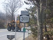
New York State Route 311
Encyclopedia
New York State Route 311 (NY 311) is a state highway
located entirely within Putnam County, New York
, United States
. The highway begins at NY 52
in Lake Carmel, and intersects Interstate 84
(I-84) shortly thereafter. It crosses NY 164
and NY 292
as it heads into the northeastern part of the county, finally curving east to reach its northern terminus at NY 22
just south of the Dutchess County
line. The route passes several historical sites.
Part of modern-day Route 311 was originally the Philipstown Turnpike, a road built in 1815 to overcome a lack of transportation when the Hudson River
froze during the winter months. The turnpike
was a large business center for the county, though it was abandoned due to insufficient tolls to maintain it. Another section was constructed in the early 1900s, from the Patterson Baptist Church near the modern-day intersection of Route 311 and Route 164
to the Village of Patterson, by a group of Italian immigrants.
In the 1930 renumbering of state highways in New York, the segment of former NY 39
east of West Patterson was renumbered to NY 311. NY 52 was realigned ca. 1937 to follow its current alignment between Stormville and Lake Carmel. The former routing of NY 52 from West Patterson to Lake Carmel became part of an extended NY 311.
 NY 311 begins at NY 52
in the Kent
hamlet of Lake Carmel
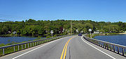
. It heads northeast, crossing over the northernmost portion of Lake Carmel
on a short causeway
. The lake has a surface area of about 200 acres (80.9 ha), and it sits at 618 feet (188.4 m) in elevation. It was created by developers in the early 20th century by damming the Middle Branch of the Croton River
, and is one of the few large bodies of water in Putnam County
not used as a reservoir by New York City
. The road then crosses into the town of Patterson
and meets I-84
by way of an interchange. Construction is planned to start in summer 2012 for general bridge rehabilitation of the I-84 interchange. Proceeding eastward, it follows an erratic path, turning in different directions due to the hilly terrain of the area. It passes by a Christian youth camp and intersects with NY 164
.
NY 311 curves gradually northeast before turning almost due north to an intersection with NY 292
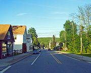
in the community of West Patterson. Past NY 292, NY 311 parallels the Putnam
–Dutchess
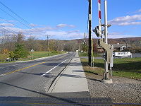
county line east into the hamlet of Patterson, serving as the main street of the community. After crossing the Harlem Line tracks, NY 311 crosses the East Branch Croton River
at the north end of the wetland area known as the Great Swamp
. At nearly 6000 acres (2,428.1 ha), the Great Swamp is the second largest wetland
in New York, extending as far north as Dover
in Dutchess County. Continuing eastward, NY 311 passes the Patterson Fire Department, and terminates at NY 22
at a junction known as Akins Corners. In the hamlet
of Patterson, an historic district
exists along the route. A number of historic sites are located on Route 311, including the Patterson Presbyterian Church, the Fellowship Hall, Christ Episcopal Church, the Maple Avenue Cemetery and the Grange Hall.
supplied cheap means of transporting goods to Albany
and New York City
, though in the winter months, the river froze over.
To resolve the issue, in 1815, the Philipstown Turnpike Company was organized to improve upon a toll road from Cold Spring
to the Connecticut
border. On April 15, 1815, "an act to incorporate the Philipstown turnpike company in the county of Putnam" was passed. East of the Connecticut border, the turnpike continued as the New Milford and Sherman Turnpike. On the turnpike, wagons transported manufactures inland, and carried produce from the eastern part of the county. Before the advent of the railroad, the road was a business center for much of the county. One of the intentions of the turnpike was to "greatly promote the public good, as well contribute to their individual interest". However, the turnpike was eventually abandoned, because the tolls received were not sufficient to defray the expense of maintaining the road and associated bridge
s. The tolls were also inadequate for investors in the Philipstown Turnpike Company to make a profit.
 In November 1901, the Putnam County's Board of Supervisors hired an engineer to create plans for a new road that would run from the Westchester
–Putnam County border into Dutchess County
. By early the next year, a group of engineers led by H. W. Degaff surveyed the region, with the goal of constructing a 16 feet (4.9 m) wide road. In October 1902, the Board of Supervisors was informed that the engineers planned to build the new road along a path similar to an existing road. Surveys were completed in 1907, resulting in the elimination of a dangerous railroad crossing
via a trestle
. Actual construction began on the Patterson portion of the state road in April 1909, beginning from the Patterson Baptist Church near the modern-day intersection of Route 311 and Route 164. The working crew was composed of Italian immigrants, some of whom were given temporary residence within the Putnam Cigar Factory. By June, the construction had reached the Village of Patterson, and was thus completed.
in West Patterson and NY 22
in Patterson was designated in the mid-1920s as part of NY 39
, an east–west route extending from Poughkeepsie
to Patterson via East Fishkill
and West Pawling. In the 1930 renumbering of state highways in New York, the segment of NY 39 east of West Patterson was renumbered to NY 311 while the portion of 1920s NY 39 from East Fishkill to West Patterson became part of NY 52
. NY 52 also continued south from West Patterson through what is now Lake Carmel
to Carmel
, where it continued east on an overlap with U.S. Route 6 (US 6).
In March 1936, a "great and unusual ice flood" caused local water levels to rise. The bridge carrying the highway over the Great Swamp received cracks in its foundation due to the pressure of the water and melting ice, and was lifted off its foundation and swept into the swamp. Ca. 1937, NY 52 was realigned to follow its current alignment between Stormville and Lake Carmel. The former routing of NY 52 from West Patterson to Lake Carmel became part of an extended NY 311.
 In June 1960, the Presbyterian Men's Club produced a film called Our Town, part of which was filmed on the Main Street portion of Route 311 at Boot Hill, a replica western frontier
town. Children were asked to participate in the filming by dressing in western or American Indian apparel; girls dressed as frontier women. The film debuted at the Patterson Town Hall on September 24, 1960.
By 1966, Putnam County's men began drafting into the armed forces to fight in the Vietnam War
. In November of that year, Local Board No. 14 announced that 21 local men would be drafted into the military, the highest total to be called since the Korean War
. Of the 21, two were residents of Patterson. To honor the Patterson veterans who lost their lives, a plaque commemorating the Vietnam War was added to the War Memorial by the American Legion
at the intersection of NY 311 and Maple Avenue.
The Patterson Post Office
underwent several re-locations throughout the years. After the Lloyd Lumber Company moved to a larger building along NY 311, the post office occupied the smaller structure; both were situated on the east side of the New York Central tracks. Residents complained that the new location was inadequate, claiming that parking
was insufficient at nearby companies, and that walking along a busy road to reach the post office was dangerous. After a bidding process to determine the future location, the office was again moved to a former car service station
along Front Street.
State highway
State highway, state road or state route can refer to one of three related concepts, two of them related to a state or provincial government in a country that is divided into states or provinces :#A...
located entirely within Putnam County, New York
Putnam County, New York
Putnam County is a county located in the U.S. state of New York, in the lower Hudson River Valley. Putnam county formed in 1812, when it detached from Dutchess County. , the population was 99,710. It is part of the New York Metropolitan Area. The county seat is the hamlet of Carmel...
, United States
United States
The United States of America is a federal constitutional republic comprising fifty states and a federal district...
. The highway begins at NY 52
New York State Route 52
New York State Route 52 is a long state highway in the southeastern part of New York in the United States. It generally runs from west to east, beginning at the Pennsylvania state line in the Delaware River near Narrowsburg, crossing the Hudson River on the Newburgh-Beacon Bridge, and ending...
in Lake Carmel, and intersects Interstate 84
Interstate 84 in New York
Interstate 84 is a part of the Interstate Highway System that runs from Dunmore, Pennsylvania, to Sturbridge, Massachusetts, in the Eastern United States. In New York, I-84 extends from the Pennsylvania state line at Port Jervis to the Connecticut state line east of Brewster...
(I-84) shortly thereafter. It crosses NY 164
New York State Route 164
New York State Route 164 is a short state highway located entirely in the town of Patterson in northeastern Putnam County, New York, United States. It is a short, two-lane back road that does not pass through any major populated areas and serves primarily as a connector between NY 311...
and NY 292
New York State Route 292
New York State Route 292 is a short state highway in the Hudson Valley of New York, United States, bridging Putnam and Dutchess Counties. The southern terminus of the route is at an intersection with NY 311 in the town of Patterson, and the northern terminus is at a junction with...
as it heads into the northeastern part of the county, finally curving east to reach its northern terminus at NY 22
New York State Route 22
New York State Route 22 is a north–south state highway in eastern New York in the United States. It runs parallel to the state's eastern edge from the outskirts of New York City to a short distance south of the Canadian border. At , it is the state's longest north–south route and...
just south of the Dutchess County
Dutchess County, New York
Dutchess County is a county located in the U.S. state of New York, in the state's Mid-Hudson Region of the Hudson Valley. The 2010 census lists the population as 297,488...
line. The route passes several historical sites.
Part of modern-day Route 311 was originally the Philipstown Turnpike, a road built in 1815 to overcome a lack of transportation when the Hudson River
Hudson River
The Hudson is a river that flows from north to south through eastern New York. The highest official source is at Lake Tear of the Clouds, on the slopes of Mount Marcy in the Adirondack Mountains. The river itself officially begins in Henderson Lake in Newcomb, New York...
froze during the winter months. The turnpike
Toll road
A toll road is a privately or publicly built road for which a driver pays a toll for use. Structures for which tolls are charged include toll bridges and toll tunnels. Non-toll roads are financed using other sources of revenue, most typically fuel tax or general tax funds...
was a large business center for the county, though it was abandoned due to insufficient tolls to maintain it. Another section was constructed in the early 1900s, from the Patterson Baptist Church near the modern-day intersection of Route 311 and Route 164
New York State Route 164
New York State Route 164 is a short state highway located entirely in the town of Patterson in northeastern Putnam County, New York, United States. It is a short, two-lane back road that does not pass through any major populated areas and serves primarily as a connector between NY 311...
to the Village of Patterson, by a group of Italian immigrants.
In the 1930 renumbering of state highways in New York, the segment of former NY 39
New York State Route 39 (1920s)
New York State Route 39 was a state highway in the Hudson Valley region of New York, United States. It stretched from NY 21 in the town of Poughkeepsie to NY 22 in Patterson, New York...
east of West Patterson was renumbered to NY 311. NY 52 was realigned ca. 1937 to follow its current alignment between Stormville and Lake Carmel. The former routing of NY 52 from West Patterson to Lake Carmel became part of an extended NY 311.
Route description
New York State Route 52
New York State Route 52 is a long state highway in the southeastern part of New York in the United States. It generally runs from west to east, beginning at the Pennsylvania state line in the Delaware River near Narrowsburg, crossing the Hudson River on the Newburgh-Beacon Bridge, and ending...
in the Kent
Kent, New York
Kent is a town in Putnam County, New York, United States. The population was 14,009 at the 2000 census. The name is that of an early settler family. The town is the north-central part of the Putnam County. Many of the lakes are reservoirs for New York City....
hamlet of Lake Carmel
Lake Carmel, New York
Lake Carmel is a hamlet located in the Town of Kent in Putnam County, New York. As of the 2000 census, the population was 8,663....
. It heads northeast, crossing over the northernmost portion of Lake Carmel
Lake Carmel (New York)
Lake Carmel is located in the Town of Kent, New York, United States. It takes its name from nearby Carmel, and in turn the community surrounding the lake, which accounts for much of Kent's population, is named for it....
on a short causeway
Causeway
In modern usage, a causeway is a road or railway elevated, usually across a broad body of water or wetland.- Etymology :When first used, the word appeared in a form such as “causey way” making clear its derivation from the earlier form “causey”. This word seems to have come from the same source by...
. The lake has a surface area of about 200 acres (80.9 ha), and it sits at 618 feet (188.4 m) in elevation. It was created by developers in the early 20th century by damming the Middle Branch of the Croton River
Croton River
The Croton River is a river in southern New York that begins where the East and West Branches of the Croton River meet a little way downstream from the Croton Falls Reservoir...
, and is one of the few large bodies of water in Putnam County
Putnam County, New York
Putnam County is a county located in the U.S. state of New York, in the lower Hudson River Valley. Putnam county formed in 1812, when it detached from Dutchess County. , the population was 99,710. It is part of the New York Metropolitan Area. The county seat is the hamlet of Carmel...
not used as a reservoir by New York City
New York City
New York is the most populous city in the United States and the center of the New York Metropolitan Area, one of the most populous metropolitan areas in the world. New York exerts a significant impact upon global commerce, finance, media, art, fashion, research, technology, education, and...
. The road then crosses into the town of Patterson
Patterson, New York
Patterson is a town in Putnam County, New York, United States. The town is in the northeast part of the county. Interstate 84 passes through the southwest part of the town. The population was 11,306 at the 2000 census. The town is named after early farmer Matthew Paterson...
and meets I-84
Interstate 84 in New York
Interstate 84 is a part of the Interstate Highway System that runs from Dunmore, Pennsylvania, to Sturbridge, Massachusetts, in the Eastern United States. In New York, I-84 extends from the Pennsylvania state line at Port Jervis to the Connecticut state line east of Brewster...
by way of an interchange. Construction is planned to start in summer 2012 for general bridge rehabilitation of the I-84 interchange. Proceeding eastward, it follows an erratic path, turning in different directions due to the hilly terrain of the area. It passes by a Christian youth camp and intersects with NY 164
New York State Route 164
New York State Route 164 is a short state highway located entirely in the town of Patterson in northeastern Putnam County, New York, United States. It is a short, two-lane back road that does not pass through any major populated areas and serves primarily as a connector between NY 311...
.
NY 311 curves gradually northeast before turning almost due north to an intersection with NY 292
New York State Route 292
New York State Route 292 is a short state highway in the Hudson Valley of New York, United States, bridging Putnam and Dutchess Counties. The southern terminus of the route is at an intersection with NY 311 in the town of Patterson, and the northern terminus is at a junction with...
in the community of West Patterson. Past NY 292, NY 311 parallels the Putnam
Putnam County, New York
Putnam County is a county located in the U.S. state of New York, in the lower Hudson River Valley. Putnam county formed in 1812, when it detached from Dutchess County. , the population was 99,710. It is part of the New York Metropolitan Area. The county seat is the hamlet of Carmel...
–Dutchess
Dutchess County, New York
Dutchess County is a county located in the U.S. state of New York, in the state's Mid-Hudson Region of the Hudson Valley. The 2010 census lists the population as 297,488...
county line east into the hamlet of Patterson, serving as the main street of the community. After crossing the Harlem Line tracks, NY 311 crosses the East Branch Croton River
Croton River
The Croton River is a river in southern New York that begins where the East and West Branches of the Croton River meet a little way downstream from the Croton Falls Reservoir...
at the north end of the wetland area known as the Great Swamp
Great Swamp (New York)
The Great Swamp in eastern Putnam and Dutchess counties is one of the largest wetlands in the U.S. State of New York.-Geography and ecology:...
. At nearly 6000 acres (2,428.1 ha), the Great Swamp is the second largest wetland
Wetland
A wetland is an area of land whose soil is saturated with water either permanently or seasonally. Wetlands are categorised by their characteristic vegetation, which is adapted to these unique soil conditions....
in New York, extending as far north as Dover
Dover, New York
Dover is a town in Dutchess County, New York, United States. The population was 8,565 at the 2000 census. The town was named after Dover in England, the home town of an early settler....
in Dutchess County. Continuing eastward, NY 311 passes the Patterson Fire Department, and terminates at NY 22
New York State Route 22
New York State Route 22 is a north–south state highway in eastern New York in the United States. It runs parallel to the state's eastern edge from the outskirts of New York City to a short distance south of the Canadian border. At , it is the state's longest north–south route and...
at a junction known as Akins Corners. In the hamlet
Hamlet
The Tragical History of Hamlet, Prince of Denmark, or more simply Hamlet, is a tragedy by William Shakespeare, believed to have been written between 1599 and 1601...
of Patterson, an historic district
Historic district
A historic district or heritage district is a section of a city which contains older buildings considered valuable for historical or architectural reasons. In some countries, historic districts receive legal protection from development....
exists along the route. A number of historic sites are located on Route 311, including the Patterson Presbyterian Church, the Fellowship Hall, Christ Episcopal Church, the Maple Avenue Cemetery and the Grange Hall.
Pre-designation history
Part of modern-day Route 311 from the NY 292 intersection to the route's ending terminus was once part of the Philipstown Turnpike. Initially, the county's proximity to the Hudson RiverHudson River
The Hudson is a river that flows from north to south through eastern New York. The highest official source is at Lake Tear of the Clouds, on the slopes of Mount Marcy in the Adirondack Mountains. The river itself officially begins in Henderson Lake in Newcomb, New York...
supplied cheap means of transporting goods to Albany
Albany, New York
Albany is the capital city of the U.S. state of New York, the seat of Albany County, and the central city of New York's Capital District. Roughly north of New York City, Albany sits on the west bank of the Hudson River, about south of its confluence with the Mohawk River...
and New York City
New York City
New York is the most populous city in the United States and the center of the New York Metropolitan Area, one of the most populous metropolitan areas in the world. New York exerts a significant impact upon global commerce, finance, media, art, fashion, research, technology, education, and...
, though in the winter months, the river froze over.
To resolve the issue, in 1815, the Philipstown Turnpike Company was organized to improve upon a toll road from Cold Spring
Cold Spring, New York
Cold Spring is a village located in the Town of Philipstown in Putnam County, New York. The population was 1,983 at the 2000 census. It borders the smaller village of Nelsonville...
to the Connecticut
Connecticut
Connecticut is a state in the New England region of the northeastern United States. It is bordered by Rhode Island to the east, Massachusetts to the north, and the state of New York to the west and the south .Connecticut is named for the Connecticut River, the major U.S. river that approximately...
border. On April 15, 1815, "an act to incorporate the Philipstown turnpike company in the county of Putnam" was passed. East of the Connecticut border, the turnpike continued as the New Milford and Sherman Turnpike. On the turnpike, wagons transported manufactures inland, and carried produce from the eastern part of the county. Before the advent of the railroad, the road was a business center for much of the county. One of the intentions of the turnpike was to "greatly promote the public good, as well contribute to their individual interest". However, the turnpike was eventually abandoned, because the tolls received were not sufficient to defray the expense of maintaining the road and associated bridge
Bridge
A bridge is a structure built to span physical obstacles such as a body of water, valley, or road, for the purpose of providing passage over the obstacle...
s. The tolls were also inadequate for investors in the Philipstown Turnpike Company to make a profit.
Westchester County, New York
Westchester County is a county located in the U.S. state of New York. Westchester covers an area of and has a population of 949,113 according to the 2010 Census, residing in 45 municipalities...
–Putnam County border into Dutchess County
Dutchess County, New York
Dutchess County is a county located in the U.S. state of New York, in the state's Mid-Hudson Region of the Hudson Valley. The 2010 census lists the population as 297,488...
. By early the next year, a group of engineers led by H. W. Degaff surveyed the region, with the goal of constructing a 16 feet (4.9 m) wide road. In October 1902, the Board of Supervisors was informed that the engineers planned to build the new road along a path similar to an existing road. Surveys were completed in 1907, resulting in the elimination of a dangerous railroad crossing
Level crossing
A level crossing occurs where a railway line is intersected by a road or path onone level, without recourse to a bridge or tunnel. It is a type of at-grade intersection. The term also applies when a light rail line with separate right-of-way or reserved track crosses a road in the same fashion...
via a trestle
Trestle
A trestle is a rigid frame used as a support, especially referring to a bridge composed of a number of short spans supported by such frames. In the context of trestle bridges, each supporting frame is generally referred to as a bent...
. Actual construction began on the Patterson portion of the state road in April 1909, beginning from the Patterson Baptist Church near the modern-day intersection of Route 311 and Route 164. The working crew was composed of Italian immigrants, some of whom were given temporary residence within the Putnam Cigar Factory. By June, the construction had reached the Village of Patterson, and was thus completed.
Designation
The portion of modern NY 311 from NY 292New York State Route 292
New York State Route 292 is a short state highway in the Hudson Valley of New York, United States, bridging Putnam and Dutchess Counties. The southern terminus of the route is at an intersection with NY 311 in the town of Patterson, and the northern terminus is at a junction with...
in West Patterson and NY 22
New York State Route 22
New York State Route 22 is a north–south state highway in eastern New York in the United States. It runs parallel to the state's eastern edge from the outskirts of New York City to a short distance south of the Canadian border. At , it is the state's longest north–south route and...
in Patterson was designated in the mid-1920s as part of NY 39
New York State Route 39 (1920s)
New York State Route 39 was a state highway in the Hudson Valley region of New York, United States. It stretched from NY 21 in the town of Poughkeepsie to NY 22 in Patterson, New York...
, an east–west route extending from Poughkeepsie
Poughkeepsie (city), New York
Poughkeepsie is a city in the state of New York, United States, which serves as the county seat of Dutchess County. Poughkeepsie is located in the Hudson River Valley midway between New York City and Albany...
to Patterson via East Fishkill
East Fishkill, New York
East Fishkill is a town on the southern border of Dutchess County, New York, United States. The population was 25,589 at the 2000 census. The town name is derived from its formation from Fishkill, NY....
and West Pawling. In the 1930 renumbering of state highways in New York, the segment of NY 39 east of West Patterson was renumbered to NY 311 while the portion of 1920s NY 39 from East Fishkill to West Patterson became part of NY 52
New York State Route 52
New York State Route 52 is a long state highway in the southeastern part of New York in the United States. It generally runs from west to east, beginning at the Pennsylvania state line in the Delaware River near Narrowsburg, crossing the Hudson River on the Newburgh-Beacon Bridge, and ending...
. NY 52 also continued south from West Patterson through what is now Lake Carmel
Lake Carmel, New York
Lake Carmel is a hamlet located in the Town of Kent in Putnam County, New York. As of the 2000 census, the population was 8,663....
to Carmel
Carmel, New York
Carmel is a town located in Putnam County, New York, USA. As of the 2000 census, the town had a total population of 36,465.There are no incorporated villages in the town, although the hamlets of Carmel and Mahopac each have populations sizable enough to be thought of as villages.The Town of Carmel...
, where it continued east on an overlap with U.S. Route 6 (US 6).
In March 1936, a "great and unusual ice flood" caused local water levels to rise. The bridge carrying the highway over the Great Swamp received cracks in its foundation due to the pressure of the water and melting ice, and was lifted off its foundation and swept into the swamp. Ca. 1937, NY 52 was realigned to follow its current alignment between Stormville and Lake Carmel. The former routing of NY 52 from West Patterson to Lake Carmel became part of an extended NY 311.
Recent history
Frontier
A frontier is a political and geographical term referring to areas near or beyond a boundary. 'Frontier' was absorbed into English from French in the 15th century, with the meaning "borderland"--the region of a country that fronts on another country .The use of "frontier" to mean "a region at the...
town. Children were asked to participate in the filming by dressing in western or American Indian apparel; girls dressed as frontier women. The film debuted at the Patterson Town Hall on September 24, 1960.
By 1966, Putnam County's men began drafting into the armed forces to fight in the Vietnam War
Vietnam War
The Vietnam War was a Cold War-era military conflict that occurred in Vietnam, Laos, and Cambodia from 1 November 1955 to the fall of Saigon on 30 April 1975. This war followed the First Indochina War and was fought between North Vietnam, supported by its communist allies, and the government of...
. In November of that year, Local Board No. 14 announced that 21 local men would be drafted into the military, the highest total to be called since the Korean War
Korean War
The Korean War was a conventional war between South Korea, supported by the United Nations, and North Korea, supported by the People's Republic of China , with military material aid from the Soviet Union...
. Of the 21, two were residents of Patterson. To honor the Patterson veterans who lost their lives, a plaque commemorating the Vietnam War was added to the War Memorial by the American Legion
American Legion
The American Legion is a mutual-aid organization of veterans of the United States armed forces chartered by the United States Congress. It was founded to benefit those veterans who served during a wartime period as defined by Congress...
at the intersection of NY 311 and Maple Avenue.
The Patterson Post Office
Post office
A post office is a facility forming part of a postal system for the posting, receipt, sorting, handling, transmission or delivery of mail.Post offices offer mail-related services such as post office boxes, postage and packaging supplies...
underwent several re-locations throughout the years. After the Lloyd Lumber Company moved to a larger building along NY 311, the post office occupied the smaller structure; both were situated on the east side of the New York Central tracks. Residents complained that the new location was inadequate, claiming that parking
Parking
Parking is the act of stopping a vehicle and leaving it unoccupied for more than a brief time. Parking on one or both sides of a road is commonly permitted, though often with restrictions...
was insufficient at nearby companies, and that walking along a busy road to reach the post office was dangerous. After a bidding process to determine the future location, the office was again moved to a former car service station
Filling station
A filling station, also known as a fueling station, garage, gasbar , gas station , petrol bunk , petrol pump , petrol garage, petrol kiosk , petrol station "'servo"' in Australia or service station, is a facility which sells fuel and lubricants...
along Front Street.
Major intersections