

New York State Route 301
Encyclopedia
New York State Route 301 (NY 301) is an intra-county state highway
stretching across three-quarters of Putnam County, New York
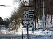
, in the United States. The western terminus of NY 301 is at an intersection with NY 9D
in Cold Spring
. Its eastern terminus is at a junction with NY 52
in Carmel
. Along the way, NY 301 meets U.S. Route 9 (US 9) and the Taconic State Parkway
and passes through Clarence Fahnestock State Park
. The section of the route between NY 9D and US 9 is ceremoniously designated as the Sergeant Albert Ireland Memorial Highway.
NY 301 was assigned as part of the 1930 renumbering of state highways in New York, but only to the portion of its modern alignment west of US 9. At the same time, the section of what is now NY 301 between Kent Cliffs and Carmel became part of New York State Route 130, an east–west route that continued southwest from Kent Cliffs to Peekskill
. NY 301 was extended east to Kent Cliffs by 1932 via the Philipstown Turnpike and to Carmel ca. 1934 by way of NY 130.
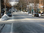
 The western terminus of NY 301 is at a four-way junction with NY 9D in Cold Spring
. At the intersection, Morris Avenue enters from the north, Chestnut Street comes in from the south, and Main Street enters from the west and leaves to the east on NY 301. The route climbs a hill into the Philipstown
village of Nelsonville
, where it remains Main Street until transitioning into Cold Spring Carmel Road and passing near the southeast border of the Hudson Highlands State Park
. It crosses US 9, locally Albany Post Road
, at Mekeel Corners and continues northeast into the woods of the Clarence Fahnestock State Park
.
The highway crosses over Clove Creek a few times and turns slightly towards the southeast; however, it soon resumes a northeasterly course as the Cold Spring Turnpike. Continuing through the state park, NY 301 skirts the southern bank of Lake Canopus
before crossing the Taconic State Parkway
in Putnam Valley
. Roughly 3.5 miles (5.6 km) to the northeast at Mead Corners, NY 301 bears southeast toward Carmel. The road passes north of Sagamore Lake to hug the western shore of Boyds Corner Reservoir
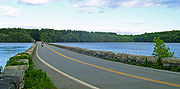
. Shortly thereafter, NY 301 follows the inside of the western fork of the West Branch Reservoir
—part of the Croton Watershed—just southwest of the Nimham Mountain State Forest, before bisecting the body of water via a causeway
.
 NY 301 ends at NY 52
(Gleneida Avenue) to the north of Lake Gleneida
in the county seat of Carmel. Lake Gleneida is a controlled lake, created when an original pond was dammed in 1870, that is part of New York City's water supply system. At the far end of the junction is the Putnam County Courthouse
, a National Register of Historic Places
-listed structure that was first constructed in 1814. The eastern terminus of NY 301 is just 0.25 mile (0.402335 km) north of NY 52's eastern terminus at US 6
.
supplied cheap means of transporting goods to Albany
and New York City
, though in the winter months, the river froze over.
To resolve the issue, in 1815, the Philipstown Turnpike Company was organized to improve upon a toll road from Cold Spring
to the Connecticut
border. On April 15, 1815, "an act to incorporate the Philipstown turnpike company in the county of Putnam" was passed. East of the Connecticut border, the turnpike continued as the New Milford and Sherman Turnpike.
 On the turnpike, wagons transported manufactures inland, and carried produce from the eastern part of the county. Before the advent of the railroad, the road was a business center for much of the county. One of the intentions of the turnpike was to "greatly promote the public good, as well contribute to their individual interest". However, the turnpike was eventually abandoned, because the tolls received were not sufficient to defray the expense of maintaining the road and associated bridge
s. The tolls were also inadequate for investors in the Philipstown Turnpike Company to make a profit.
in Carmel
was designated as part of NY 130, which continued southwest from Kent Cliffs to Peekskill
via CR 21, Oregon Road, and Division Street. By 1932, NY 301 was extended eastward to NY 130 in Kent Cliffs by way of its modern alignment. NY 130 was replaced by an extended NY 301 from Kent Cliffs to Carmel ca. 1934 and eliminated entirely ca. 1938.
The section of NY 301 from the vicinity of Kittridge Drive, a local street southeast of Kent Cliffs, to NY 52 was initially county-maintained as CR 47. On April 1, 1980, ownership and maintenance of this section of the route was transferred to the state of New York as part of a highway maintenance swap between the two levels of government. The concurrent
CR 47 designation was subsequently eliminated; however, the number was later reused for a 0.2 mile (0.321868 km) former alignment of NY 301 in Kent Cliffs.
On August 20, 2002, the portion of NY 301 between NY 9D and US 9 was designated as the "Sergeant Albert Ireland Memorial Highway". The ceremonial designation honors Albert Luke Ireland, a U.S. Marine Corps Sergeant from Cold Spring that was awarded many citations, including nine Purple Heart
s, for his service during World War II
and the Korean War
.
State highway
State highway, state road or state route can refer to one of three related concepts, two of them related to a state or provincial government in a country that is divided into states or provinces :#A...
stretching across three-quarters of Putnam County, New York
Putnam County, New York
Putnam County is a county located in the U.S. state of New York, in the lower Hudson River Valley. Putnam county formed in 1812, when it detached from Dutchess County. , the population was 99,710. It is part of the New York Metropolitan Area. The county seat is the hamlet of Carmel...
, in the United States. The western terminus of NY 301 is at an intersection with NY 9D
New York State Route 9D
New York State Route 9D , also known as the Bear Mountain – Beacon Highway, is a north–south state highway that runs along the eastern shore of the Hudson River in New York in the United States. It starts at the eastern end of the Bear Mountain Bridge at U.S...
in Cold Spring
Cold Spring, New York
Cold Spring is a village located in the Town of Philipstown in Putnam County, New York. The population was 1,983 at the 2000 census. It borders the smaller village of Nelsonville...
. Its eastern terminus is at a junction with NY 52
New York State Route 52
New York State Route 52 is a long state highway in the southeastern part of New York in the United States. It generally runs from west to east, beginning at the Pennsylvania state line in the Delaware River near Narrowsburg, crossing the Hudson River on the Newburgh-Beacon Bridge, and ending...
in Carmel
Carmel, New York
Carmel is a town located in Putnam County, New York, USA. As of the 2000 census, the town had a total population of 36,465.There are no incorporated villages in the town, although the hamlets of Carmel and Mahopac each have populations sizable enough to be thought of as villages.The Town of Carmel...
. Along the way, NY 301 meets U.S. Route 9 (US 9) and the Taconic State Parkway
Taconic State Parkway
The Taconic State Parkway , is a divided highway between Kensico Dam and Chatham, the longest parkway in the U.S. state of New York. It follows a generally northward route midway between the Hudson River and the Connecticut and Massachusetts state lines...
and passes through Clarence Fahnestock State Park
Clarence Fahnestock State Park
Clarence Fahnestock Memorial State Park a 14,086 acre New York state park, in Putnam and Dutchess counties. The park has hiking trails, an environmental center, a beach on Canopus Lake, and fishing on four ponds and two lakes...
. The section of the route between NY 9D and US 9 is ceremoniously designated as the Sergeant Albert Ireland Memorial Highway.
NY 301 was assigned as part of the 1930 renumbering of state highways in New York, but only to the portion of its modern alignment west of US 9. At the same time, the section of what is now NY 301 between Kent Cliffs and Carmel became part of New York State Route 130, an east–west route that continued southwest from Kent Cliffs to Peekskill
Peekskill, New York
Peekskill is a city in Westchester County, New York. It is situated on a bay along the east side of the Hudson River, across from Jones Point.This community was known to be an early American industrial center, primarily for its iron plow and stove products...
. NY 301 was extended east to Kent Cliffs by 1932 via the Philipstown Turnpike and to Carmel ca. 1934 by way of NY 130.
Route description
Cold Spring, New York
Cold Spring is a village located in the Town of Philipstown in Putnam County, New York. The population was 1,983 at the 2000 census. It borders the smaller village of Nelsonville...
. At the intersection, Morris Avenue enters from the north, Chestnut Street comes in from the south, and Main Street enters from the west and leaves to the east on NY 301. The route climbs a hill into the Philipstown
Philipstown, New York
Philipstown is a town located in the western part of Putnam County, New York, United States. The population was 9,422 at the 2000 census.- History :The town was first settled around 1715....
village of Nelsonville
Nelsonville, New York
Nelsonville is a Hudson Highlands village located in the Town of Philipstown in Putnam County, New York. The population was 565 at the time of the 2000 census.The Village of Nelsonville is directly east of the Village of Cold Spring...
, where it remains Main Street until transitioning into Cold Spring Carmel Road and passing near the southeast border of the Hudson Highlands State Park
Hudson Highlands State Park
Hudson Highlands State Park is a non-contiguous state park in the U.S. state of New York, located on the east side of the Hudson River. The park runs from Peekskill in Westchester County, through Putnam County, to Beacon in Dutchess County, in the eastern section of the Hudson Highlands.The park's...
. It crosses US 9, locally Albany Post Road
Albany Post Road
The Albany Post Road was a post road - a road used for mail delivery - in the U.S. state of New York. It connected the cities of New York and Albany along the east side of the Hudson River, a service now performed by US 9.The rough route was as follows:...
, at Mekeel Corners and continues northeast into the woods of the Clarence Fahnestock State Park
Clarence Fahnestock State Park
Clarence Fahnestock Memorial State Park a 14,086 acre New York state park, in Putnam and Dutchess counties. The park has hiking trails, an environmental center, a beach on Canopus Lake, and fishing on four ponds and two lakes...
.
The highway crosses over Clove Creek a few times and turns slightly towards the southeast; however, it soon resumes a northeasterly course as the Cold Spring Turnpike. Continuing through the state park, NY 301 skirts the southern bank of Lake Canopus
Lake Canopus
Lake Canopus is a small lake above the southern shore of Lake Vanda in Wright Valley, Victoria Land. It was named by the Eighth Victoria University of Wellington Antarctic Expedition, 1963–64, after Canopus, pilot of Menelaus, the king of Sparta....
before crossing the Taconic State Parkway
Taconic State Parkway
The Taconic State Parkway , is a divided highway between Kensico Dam and Chatham, the longest parkway in the U.S. state of New York. It follows a generally northward route midway between the Hudson River and the Connecticut and Massachusetts state lines...
in Putnam Valley
Putnam Valley, New York
Putnam Valley is a town in Putnam County, New York, United States. The population was 10,686 at the 2000 census. Its location is northeast of New York City.The Town of Putnam Valley is in the southwest part of Putnam County...
. Roughly 3.5 miles (5.6 km) to the northeast at Mead Corners, NY 301 bears southeast toward Carmel. The road passes north of Sagamore Lake to hug the western shore of Boyds Corner Reservoir
Boyds Corner Reservoir
The Boyds Corner Reservoir is a small reservoir in Putnam County, New York. It is in the town of Kent, New York, and is about 50 miles north of New York City...
. Shortly thereafter, NY 301 follows the inside of the western fork of the West Branch Reservoir
West Branch Reservoir
The West Branch Reservoir, formed by impounding about one quarter of the West Branch of the Croton River, is located in Putnam County, New York, United States, in the towns of Kent, New York, and Carmel, New York, and is only about north of New York City's Central Park Reservoir.The West Branch is...
—part of the Croton Watershed—just southwest of the Nimham Mountain State Forest, before bisecting the body of water via a causeway
Causeway
In modern usage, a causeway is a road or railway elevated, usually across a broad body of water or wetland.- Etymology :When first used, the word appeared in a form such as “causey way” making clear its derivation from the earlier form “causey”. This word seems to have come from the same source by...
.
New York State Route 52
New York State Route 52 is a long state highway in the southeastern part of New York in the United States. It generally runs from west to east, beginning at the Pennsylvania state line in the Delaware River near Narrowsburg, crossing the Hudson River on the Newburgh-Beacon Bridge, and ending...
(Gleneida Avenue) to the north of Lake Gleneida
Lake Gleneida
Lake Gleneida is a controlled lake in Carmel, New York, United States. It is part of New York City's water supply system, created when an original pond was dammed in 1870.-Geography:...
in the county seat of Carmel. Lake Gleneida is a controlled lake, created when an original pond was dammed in 1870, that is part of New York City's water supply system. At the far end of the junction is the Putnam County Courthouse
Putnam County Courthouse (New York)
New York's Putnam County Courthouse is located on Gleneida Avenue across from the eastern terminus of NY 301 in downtown Carmel, the county seat, overlooking Lake Gleneida. First built in 1814, two years after the county itself was established, it is the second-oldest county courthouse still in...
, a National Register of Historic Places
National Register of Historic Places
The National Register of Historic Places is the United States government's official list of districts, sites, buildings, structures, and objects deemed worthy of preservation...
-listed structure that was first constructed in 1814. The eastern terminus of NY 301 is just 0.25 mile (0.402335 km) north of NY 52's eastern terminus at US 6
U.S. Route 6 in New York
U.S. Route 6 is a part of the U.S. Highway System that runs from Bishop, California, to Provincetown, Massachusetts. In New York, US 6 extends from the Pennsylvania state line at Port Jervis to the Connecticut state line east of Brewster...
.
Philipstown Turnpike
The portion of modern-day NY 301 west of Meads Corners was originally part of the Philipstown Turnpike. Initially, the county's proximity to the Hudson RiverHudson River
The Hudson is a river that flows from north to south through eastern New York. The highest official source is at Lake Tear of the Clouds, on the slopes of Mount Marcy in the Adirondack Mountains. The river itself officially begins in Henderson Lake in Newcomb, New York...
supplied cheap means of transporting goods to Albany
Albany, New York
Albany is the capital city of the U.S. state of New York, the seat of Albany County, and the central city of New York's Capital District. Roughly north of New York City, Albany sits on the west bank of the Hudson River, about south of its confluence with the Mohawk River...
and New York City
New York City
New York is the most populous city in the United States and the center of the New York Metropolitan Area, one of the most populous metropolitan areas in the world. New York exerts a significant impact upon global commerce, finance, media, art, fashion, research, technology, education, and...
, though in the winter months, the river froze over.
To resolve the issue, in 1815, the Philipstown Turnpike Company was organized to improve upon a toll road from Cold Spring
Cold Spring, New York
Cold Spring is a village located in the Town of Philipstown in Putnam County, New York. The population was 1,983 at the 2000 census. It borders the smaller village of Nelsonville...
to the Connecticut
Connecticut
Connecticut is a state in the New England region of the northeastern United States. It is bordered by Rhode Island to the east, Massachusetts to the north, and the state of New York to the west and the south .Connecticut is named for the Connecticut River, the major U.S. river that approximately...
border. On April 15, 1815, "an act to incorporate the Philipstown turnpike company in the county of Putnam" was passed. East of the Connecticut border, the turnpike continued as the New Milford and Sherman Turnpike.
Bridge
A bridge is a structure built to span physical obstacles such as a body of water, valley, or road, for the purpose of providing passage over the obstacle...
s. The tolls were also inadequate for investors in the Philipstown Turnpike Company to make a profit.
Designation and recent history
NY 301 was assigned as part of the 1930 renumbering of state highways in New York to the portion of its modern alignment west of US 9. At the same time, the section of what is now NY 301 from County Route 21 (CR 21) in Kent Cliffs to NY 52New York State Route 52
New York State Route 52 is a long state highway in the southeastern part of New York in the United States. It generally runs from west to east, beginning at the Pennsylvania state line in the Delaware River near Narrowsburg, crossing the Hudson River on the Newburgh-Beacon Bridge, and ending...
in Carmel
Carmel, New York
Carmel is a town located in Putnam County, New York, USA. As of the 2000 census, the town had a total population of 36,465.There are no incorporated villages in the town, although the hamlets of Carmel and Mahopac each have populations sizable enough to be thought of as villages.The Town of Carmel...
was designated as part of NY 130, which continued southwest from Kent Cliffs to Peekskill
Peekskill, New York
Peekskill is a city in Westchester County, New York. It is situated on a bay along the east side of the Hudson River, across from Jones Point.This community was known to be an early American industrial center, primarily for its iron plow and stove products...
via CR 21, Oregon Road, and Division Street. By 1932, NY 301 was extended eastward to NY 130 in Kent Cliffs by way of its modern alignment. NY 130 was replaced by an extended NY 301 from Kent Cliffs to Carmel ca. 1934 and eliminated entirely ca. 1938.
The section of NY 301 from the vicinity of Kittridge Drive, a local street southeast of Kent Cliffs, to NY 52 was initially county-maintained as CR 47. On April 1, 1980, ownership and maintenance of this section of the route was transferred to the state of New York as part of a highway maintenance swap between the two levels of government. The concurrent
Concurrency (road)
A concurrency, overlap, or coincidence in a road network is an instance of one physical road bearing two or more different highway, motorway, or other route numbers...
CR 47 designation was subsequently eliminated; however, the number was later reused for a 0.2 mile (0.321868 km) former alignment of NY 301 in Kent Cliffs.
On August 20, 2002, the portion of NY 301 between NY 9D and US 9 was designated as the "Sergeant Albert Ireland Memorial Highway". The ceremonial designation honors Albert Luke Ireland, a U.S. Marine Corps Sergeant from Cold Spring that was awarded many citations, including nine Purple Heart
Purple Heart
The Purple Heart is a United States military decoration awarded in the name of the President to those who have been wounded or killed while serving on or after April 5, 1917 with the U.S. military. The National Purple Heart Hall of Honor is located in New Windsor, New York...
s, for his service during World War II
World War II
World War II, or the Second World War , was a global conflict lasting from 1939 to 1945, involving most of the world's nations—including all of the great powers—eventually forming two opposing military alliances: the Allies and the Axis...
and the Korean War
Korean War
The Korean War was a conventional war between South Korea, supported by the United Nations, and North Korea, supported by the People's Republic of China , with military material aid from the Soviet Union...
.
Major intersections
See also
- List of articles on transportation in Putnam County, New York