
New York Bight
Encyclopedia

Bight (geography)
In geography, bight has two meanings. A bight can be simply a bend or curve in any geographical feature—usually a bend or curve in the line between land and water....
is a slight indentation along the Atlantic coast
Eastern seaboard
An Eastern seaboard can mean any easternmost part of a continent, or its countries, states and/or cities.Eastern seaboard may also refer to:* East Coast of Australia* East Coast of the United States* Eastern Seaboard of Thailand-See also:...
of the United States, extending northeasterly from Cape May
Cape May
Cape May is a peninsula and island ; the southern tip of the island is the southernmost point of the state of New Jersey, United States. It runs southwards from the New Jersey mainland, separating Delaware Bay from the Atlantic Ocean...
Inlet in New Jersey to Montauk Point on the eastern tip of Long Island
Long Island
Long Island is an island located in the southeast part of the U.S. state of New York, just east of Manhattan. Stretching northeast into the Atlantic Ocean, Long Island contains four counties, two of which are boroughs of New York City , and two of which are mainly suburban...
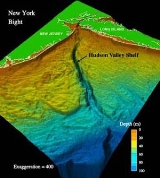
. The sea floor of the bight consists largely of continental shelf
Continental shelf
The continental shelf is the extended perimeter of each continent and associated coastal plain. Much of the shelf was exposed during glacial periods, but is now submerged under relatively shallow seas and gulfs, and was similarly submerged during other interglacial periods. The continental margin,...
and includes the Hudson Canyon
Hudson Canyon
__notoc__The Hudson Canyon is a submarine canyon that begins from the shallow outlet of the estuary at the mouth of the Hudson River. It extends out over seaward across the continental shelf finally connecting to the deep ocean basin at a depth of 3 to 4 km below sea level...
, an undersea Pleistocene
Pleistocene
The Pleistocene is the epoch from 2,588,000 to 11,700 years BP that spans the world's recent period of repeated glaciations. The name pleistocene is derived from the Greek and ....
submarine canyon
Submarine canyon
A submarine canyon is a steep-sided valley on the sea floor of the continental slope. Many submarine canyons are found as extensions to large rivers; however there are some that have no such association. Canyons cutting the continental slopes have been found at depths greater than 2 km below sea...
, which was formed by the Hudson River during the ice age
Ice age
An ice age or, more precisely, glacial age, is a generic geological period of long-term reduction in the temperature of the Earth's surface and atmosphere, resulting in the presence or expansion of continental ice sheets, polar ice sheets and alpine glaciers...
s, when the sea level was lower. The bight includes major shipping channels that access New York Harbor. The coastal climate of the gulf is temperate as the result of direct contact from the Gulf Stream
Gulf Stream
The Gulf Stream, together with its northern extension towards Europe, the North Atlantic Drift, is a powerful, warm, and swift Atlantic ocean current that originates at the tip of Florida, and follows the eastern coastlines of the United States and Newfoundland before crossing the Atlantic Ocean...
along the coast of North America.
The geography of the bight is such that the coast makes a nearly right angle
Right angle
In geometry and trigonometry, a right angle is an angle that bisects the angle formed by two halves of a straight line. More precisely, if a ray is placed so that its endpoint is on a line and the adjacent angles are equal, then they are right angles...
bend at the mouth of the Hudson. This feature has long been of major concern to meteorologists in the study of tropical storm patterns along the east coast, and is one of the primary reasons why the New York Metropolitan Area
New York metropolitan area
The New York metropolitan area, also known as Greater New York, or the Tri-State area, is the region that composes of New York City and the surrounding region...
is considered a high danger zone for storm generated ocean-water surges, despite its northerly latitude. Specifically, in the presence of a hurricane off the coast of New Jersey, the easterly cyclonic winds along the northern edge of the storm could drive a strong surge to the west, laterally along the southern coast of Long Island and straight into Lower New York Bay
Lower New York Bay
Lower New York Bay is that section of New York Bay south of the Narrows, the relatively narrow strait between the shores of Staten Island and Brooklyn. The southern end of the bay opens directly to the Atlantic Ocean between two spits of land, Sandy Hook, New Jersey, and Rockaway, Queens, on Long...
. The angle bend of the New Jersey coast would leave little outlet for the surge, leading to widespread flooding throughout New York City
New York City
New York is the most populous city in the United States and the center of the New York Metropolitan Area, one of the most populous metropolitan areas in the world. New York exerts a significant impact upon global commerce, finance, media, art, fashion, research, technology, education, and...
, especially along the southern coast of Staten Island
Staten Island
Staten Island is a borough of New York City, New York, United States, located in the southwest part of the city. Staten Island is separated from New Jersey by the Arthur Kill and the Kill Van Kull, and from the rest of New York by New York Bay...
and Manhattan
Manhattan
Manhattan is the oldest and the most densely populated of the five boroughs of New York City. Located primarily on the island of Manhattan at the mouth of the Hudson River, the boundaries of the borough are identical to those of New York County, an original county of the state of New York...
; storm surge
Storm surge
A storm surge is an offshore rise of water associated with a low pressure weather system, typically tropical cyclones and strong extratropical cyclones. Storm surges are caused primarily by high winds pushing on the ocean's surface. The wind causes the water to pile up higher than the ordinary sea...
s of up to 30 feet (9.1 m) were reported in the hurricane of 1893
1893 New York hurricane
The 1893 New York hurricane was a powerful and destructive tropical cyclone that struck the New York City area in August 1893. First identified as a tropical storm on August 15, over the central Atlantic Ocean, the hurricane moved northwestward for most of its course, ultimately peaking with...
.The New York Bight Apex is the area including and between the Hudson River estuary
Estuary
An estuary is a partly enclosed coastal body of water with one or more rivers or streams flowing into it, and with a free connection to the open sea....
and the Raritan
Raritan
-Places:*Raritan, New Jersey, a borough in Somerset County*Raritan Township, New Jersey, a township in Hunterdon County*Raritan Bay, a bay between the U.S...
River estuary extending 6-7 km of the coast and includes Raritan Bay
Raritan Bay
Raritan Bay is a bay located at the southern portion of Lower New York Bay between the U.S. states of New York and New Jersey and is part of the New York Bight. The bay is bounded on the northwest by New York's Staten Island, on the west by Perth Amboy, New Jersey, on the south by the Raritan...
and Lower New York Bay
Lower New York Bay
Lower New York Bay is that section of New York Bay south of the Narrows, the relatively narrow strait between the shores of Staten Island and Brooklyn. The southern end of the bay opens directly to the Atlantic Ocean between two spits of land, Sandy Hook, New Jersey, and Rockaway, Queens, on Long...
.