The
New Orleans Hurricane of 1915 was an intense
Category 4The Saffir–Simpson Hurricane Scale , or the Saffir–Simpson Hurricane Wind Scale , classifies hurricanes — Western Hemisphere tropical cyclones that exceed the intensities of tropical depressions and tropical storms — into five categories distinguished by the intensities of their sustained winds...
hurricaneA tropical cyclone is a storm system characterized by a large low-pressure center and numerous thunderstorms that produce strong winds and heavy rain. Tropical cyclones strengthen when water evaporated from the ocean is released as the saturated air rises, resulting in condensation of water vapor...
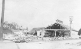
that made landfall near
Grand Isle, LouisianaGrand Isle is a town in Jefferson Parish, Louisiana, located on a barrier island of the same name in the Gulf of Mexico. The island is at the mouth of Barataria Bay where it meets the gulf. As of the 2000 census, the town population was 1,541; during summers, the population sometimes increases to...
during the
1915 Atlantic hurricane seasonThe 1915 Atlantic hurricane season ran through the summer and the first half of fall in 1915.-Storms:The 1915 season was not very active in terms of the number of storms but it was fairly eventful, with two powerful hurricanes hitting the Gulf Coast of the United States.-Hurricane One:The first...
. The hurricane killed 275 people and caused $13 million (1915 US dollars) in damage.
Meteorological history
The storm was first reported near the
Lesser AntillesThe Lesser Antilles are a long, partly volcanic island arc in the Western Hemisphere. Most of its islands form the eastern boundary of the Caribbean Sea with the Atlantic Ocean, with the remainder located in the southern Caribbean just north of South America...
between
Puerto RicoPuerto Rico , officially the Commonwealth of Puerto Rico , is an unincorporated territory of the United States, located in the northeastern Caribbean, east of the Dominican Republic and west of both the United States Virgin Islands and the British Virgin Islands.Puerto Rico comprises an...
and South America. In the Caribbean, it strengthened to a 145 mph (230 km/h) Category 4 hurricane on September 25. As the hurricane moved closer to the
Gulf CoastThe Gulf Coast of the United States, sometimes referred to as the Gulf South, South Coast, or 3rd Coast, comprises the coasts of American states that are on the Gulf of Mexico, which includes Texas, Louisiana, Mississippi, Alabama, and Florida and are known as the Gulf States...
, hurricane warnings were put up from
FloridaFlorida is a state in the southeastern United States, located on the nation's Atlantic and Gulf coasts. It is bordered to the west by the Gulf of Mexico, to the north by Alabama and Georgia and to the east by the Atlantic Ocean. With a population of 18,801,310 as measured by the 2010 census, it...
to
LouisianaLouisiana is a state located in the southern region of the United States of America. Its capital is Baton Rouge and largest city is New Orleans. Louisiana is the only state in the U.S. with political subdivisions termed parishes, which are local governments equivalent to counties...
. The storm made landfall near
Grand Isle, LouisianaGrand Isle is a town in Jefferson Parish, Louisiana, located on a barrier island of the same name in the Gulf of Mexico. The island is at the mouth of Barataria Bay where it meets the gulf. As of the 2000 census, the town population was 1,541; during summers, the population sometimes increases to...
on September 29 as a strong Category 3 hurricane with 125 mph (200 km/h) sustained winds. The storm then moved northeast and weakened into a tropical storm as it crossed into
MississippiMississippi is a U.S. state located in the Southern United States. Jackson is the state capital and largest city. The name of the state derives from the Mississippi River, which flows along its western boundary, whose name comes from the Ojibwe word misi-ziibi...
,
AlabamaAlabama is a state located in the southeastern region of the United States. It is bordered by Tennessee to the north, Georgia to the east, Florida and the Gulf of Mexico to the south, and Mississippi to the west. Alabama ranks 30th in total land area and ranks second in the size of its inland...
and
TennesseeTennessee is a U.S. state located in the Southeastern United States. It has a population of 6,346,105, making it the nation's 17th-largest state by population, and covers , making it the 36th-largest by total land area...
. The storm became extratropical as it moved north.
New Orleans
In
New OrleansNew Orleans is a major United States port and the largest city and metropolitan area in the state of Louisiana. The New Orleans metropolitan area has a population of 1,235,650 as of 2009, the 46th largest in the USA. The New Orleans – Metairie – Bogalusa combined statistical area has a population...
winds of 50 mi/h reached the city at 7am, climbing to 60 miles (96.6 km) an hour over the next 5 hours. Hurricane conditions were experienced from the afternoon into the night, with steady winds of 86 mi/h and gusts up to 120 mi/h.
There were reports of damage in
New OrleansNew Orleans is a major United States port and the largest city and metropolitan area in the state of Louisiana. The New Orleans metropolitan area has a population of 1,235,650 as of 2009, the 46th largest in the USA. The New Orleans – Metairie – Bogalusa combined statistical area has a population...
, with roofs blown off buildings and
the PresbytèreThe Presbytère, also known as The Presbytere, is an important historical building in New Orleans, Louisiana and is located in the French Quarter along Jackson Square, adjacent to the St...
on Jackson Square losing its cupola. The clock on
St. Louis CathedralSaint Louis Cathedral , also known as the Basilica of St. Louis, King of France, is the seat of the Roman Catholic Archdiocese of New Orleans; it has the distinction of being the oldest continuously operating cathedral in the United States...
stopped at 5:50pm, the height of the storm. The hurricane damaged the Times-Picayune building, hampering newspaper production. More church
steeplesA steeple, in architecture, is a tall tower on a building, often topped by a spire. Steeples are very common on Christian churches and cathedrals and the use of the term generally connotes a religious structure...
in the city were blown down or significantly damaged than remained intact.
The landmark Presbyterian Church on Lafayette Square collapsed, as did St. Anna's Episcopal Church on Esplanade Avenue. Half the rides at
Spanish FortSpanish Fort, also known as Old Spanish Fort, Fort St. Jean, and Fort St. John, is a historic place in New Orleans, Louisiana, formerly the site of a fort and later an amusement park.-The fort:...
were destroyed. Horticultural Hall in Audubon Park was destroyed. Wind damage was worse than the most recent previous hurricane to hit the city in 1909, but flooding was much less widespread; however, there were reports of waters from Lake Pontchartrain being forced backwards into the city's drainage canals by the storm, an event which would be repeated more catastrophically with
Hurricane KatrinaHurricane Katrina of the 2005 Atlantic hurricane season was a powerful Atlantic hurricane. It is the costliest natural disaster, as well as one of the five deadliest hurricanes, in the history of the United States. Among recorded Atlantic hurricanes, it was the sixth strongest overall...
90 years later. After power to drainage pumps failed, parts of the Mid-City neighborhood suffered significant flooding.
Only 21 of the storm-related deaths were within the city.
Southeast Louisiana
A 13 feet (4 m)
storm surgeA storm surge is an offshore rise of water associated with a low pressure weather system, typically tropical cyclones and strong extratropical cyclones. Storm surges are caused primarily by high winds pushing on the ocean's surface. The wind causes the water to pile up higher than the ordinary sea...
rolled into St. Bernard Parish, the Rigolets, and the Lake Catherine area.
Areas along the Lower Coast (south of New Orleans) were hit even harder than the city. A telegraph report states the situation:
- "Whole country between Poydras
Poydras is a census-designated place in St. Bernard Parish, Louisiana, United States. The population was 3,886 at the 2000 census. It is part of the New Orleans–Metairie–Kenner Metropolitan Statistical Area...
and Buras inundated. Levees gone, property loss appalling. Life toll probably heavy. Conditions estimated worse than ever before. Relief needed. No Communications..."
There were 23 dead in
Venice, LouisianaVenice is an unincorporated community in Plaquemines Parish, Louisiana, United States. It is 130 km south of New Orleans on the west bank of the Mississippi River at . It is the last community down the Mississippi accessible by automobile, and is the southern terminus of the Great River Road...
, with similar numbers in coastal towns of Frenier and LaBranche. Plaquemines Parish experienced the worst fatalities with deaths estimated at over 200; the bodies of some victims were never found. In Plaquemines Parish, there was severe flooding and miles of levees were washed away. Thousands of people were left homeless. The hurricane also wrecked many of the oyster boats, damaging the local economy.
Some communities, including
Breton IslandBreton Island is a small rocky island lying southwest of Empereur Island. It was charted in 1950 by the French Antarctic Expedition and named by them for their largely Breton crew....
and the town of
Saint MaloSaint Malo was a small fishing village that existed in St. Bernard Parish, Louisiana on the shore of Lake Borgne from the mid 18th century into the early 20th century, when it was destroyed by the New Orleans Hurricane of 1915. It was the first settlement of Filipinos in the United...
were completely destroyed.
Though it was not as deadly as the
1893 Chenier Caminanda HurricaneThe Chenière Caminada Hurricane, also known as the Great October Storm, was a powerful hurricane that devastated the island of Chenière Caminada, Louisiana in early October 1893...
, this hurricane was the deadliest Louisiana hurricane until
Hurricane BetsyHurricane Betsy was a Category 4 hurricane of the 1965 Atlantic hurricane season which caused enormous damage in the Bahamas, Florida, and Louisiana. Betsy made its most intense landfall near the mouth of the Mississippi River, causing significant flooding of the waters of Lake Pontchartrain into...
50 years later.
See also
- List of tropical cyclones
- List of Atlantic hurricanes
External links