

New England Interstate Route 9
Encyclopedia
Route 9 is a multi-state state highway
in the New England
region of the United States
, running across the southern parts of New Hampshire
, Vermont
and Maine
, and numbered, owned, and maintained by each of those states. Its number was assigned in 1922, when it was designated one of the New England Interstate Routes, also known as the Bennington-Wells Route. Much of the route remains intact in Vermont and New Hampshire. In Maine, however, Route 9 has since been extended eastward by about 270 miles (435 km) from its original terminus in Wells, through Biddeford
, Portland, and Bangor, to the Canadian border
in Calais.
and Keene
, to Wells
. When New York first signed its state highways in 1924, the westward continuation of the route towards Troy
was also designated as New York State Route 9. In 1927, however, because of the designation of U.S. Route 9, New York renumbered its former Route 9 as Route 7. By the beginning of 1934, Maine extended its portion of Route 9 by about 270 miles (434.5 km) to the Canadian border in Calais
, creating an alternate route to U.S. Route 1.
state line in Bennington, Vermont, where it continues west as Route 7
. It crosses the Connecticut River
from Brattleboro, Vermont
into Chesterfield, New Hampshire
. Route 9 in Vermont is also known as the Molly Stark
Byway.
The VT Route 9 section between the eastern outskirts of Bennington, Vermont and Searsburg, Vermont across Woodford Mountain is notorious for its steep and winding bends, which over the years have contributed to a number of tractor-trailer incidents on this stretch of the road.
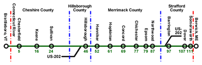
, Concord
and Dover
. It runs concurrent with U.S. Route 202
for much of its path across the Granite State. The concurrent section of Route 202/9 between Hillsborough
and Hopkinton
, which passes through Henniker
, is considered one of the most deadly sections of road in the state.http://www.cmonitor.com/apps/pbcs.dll/article?AID=/20050605/REPOSITORY/506050432/1031 Route 9 crosses the Salmon Falls River
from Somersworth, New Hampshire
into Berwick, Maine.
Route 9A is an alternate route in Chesterfield.
- and becomes Route 1 in the province of New Brunswick
.
, New Hampshire
. The route terminates at New Hampshire Route 9 at both ends and provides access to Spofford Lake
from NH 9.
State highway
State highway, state road or state route can refer to one of three related concepts, two of them related to a state or provincial government in a country that is divided into states or provinces :#A...
in the New England
New England
New England is a region in the northeastern corner of the United States consisting of the six states of Maine, New Hampshire, Vermont, Massachusetts, Rhode Island, and Connecticut...
region of the United States
United States
The United States of America is a federal constitutional republic comprising fifty states and a federal district...
, running across the southern parts of New Hampshire
New Hampshire
New Hampshire is a state in the New England region of the northeastern United States of America. The state was named after the southern English county of Hampshire. It is bordered by Massachusetts to the south, Vermont to the west, Maine and the Atlantic Ocean to the east, and the Canadian...
, Vermont
Vermont
Vermont is a state in the New England region of the northeastern United States of America. The state ranks 43rd in land area, , and 45th in total area. Its population according to the 2010 census, 630,337, is the second smallest in the country, larger only than Wyoming. It is the only New England...
and Maine
Maine
Maine is a state in the New England region of the northeastern United States, bordered by the Atlantic Ocean to the east and south, New Hampshire to the west, and the Canadian provinces of Quebec to the northwest and New Brunswick to the northeast. Maine is both the northernmost and easternmost...
, and numbered, owned, and maintained by each of those states. Its number was assigned in 1922, when it was designated one of the New England Interstate Routes, also known as the Bennington-Wells Route. Much of the route remains intact in Vermont and New Hampshire. In Maine, however, Route 9 has since been extended eastward by about 270 miles (435 km) from its original terminus in Wells, through Biddeford
Biddeford, Maine
Biddeford is a town in York County, Maine, United States. It is the largest town in the county, and is the sixth-largest in the state. It is the most southerly incorporated town in the state and the principal commercial center of York County. The population was 21,277 at the 2010 census...
, Portland, and Bangor, to the Canadian border
Canada-United States border
The Canada–United States border, officially known as the International Boundary, is the longest border in the world. The terrestrial boundary is 8,891 kilometers long, including 2,475 kilometres shared with Alaska...
in Calais.
History
Route 9 originally extended 167 miles (268.8 km) across the southern part of Vermont, New Hampshire, and Maine, from the New York-Vermont border in Bennington, via BrattleboroBrattleboro, Vermont
Brattleboro, originally Brattleborough, is a town in Windham County, Vermont, United States, located in the southeast corner of the state, along the state line with New Hampshire. The population was 12,046 at the 2010 census...
and Keene
Keene, New Hampshire
Keene is a city in Cheshire County, New Hampshire, United States. The population was 23,409 at the 2010 census. It is the county seat of Cheshire County.Keene is home to Keene State College and Antioch University New England, and hosts the annual Pumpkin Fest...
, to Wells
Wells, Maine
Wells is a town in York County, Maine, United States. Founded in 1643, it is the third-oldest town in Maine. The population was 9,400 at the 2000 census. Wells Beach is a popular summer destination.-History:...
. When New York first signed its state highways in 1924, the westward continuation of the route towards Troy
Troy, New York
Troy is a city in the US State of New York and the seat of Rensselaer County. Troy is located on the western edge of Rensselaer County and on the eastern bank of the Hudson River. Troy has close ties to the nearby cities of Albany and Schenectady, forming a region popularly called the Capital...
was also designated as New York State Route 9. In 1927, however, because of the designation of U.S. Route 9, New York renumbered its former Route 9 as Route 7. By the beginning of 1934, Maine extended its portion of Route 9 by about 270 miles (434.5 km) to the Canadian border in Calais
Calais, Maine
Calais is a city in Washington County, Maine, United States. The city has three United States border crossings or also known as a Port of entry with the busiest being on the St. Croix River bordering St. Stephen, New Brunswick, Canada...
, creating an alternate route to U.S. Route 1.
Vermont
Vermont Route 9 begins at the New YorkNew York
New York is a state in the Northeastern region of the United States. It is the nation's third most populous state. New York is bordered by New Jersey and Pennsylvania to the south, and by Connecticut, Massachusetts and Vermont to the east...
state line in Bennington, Vermont, where it continues west as Route 7
New York State Route 7
New York State Route 7 is a 180-mile long New York State Highway that runs from the New York/Pennsylvania border south of Binghamton, New York to the New York/Vermont border east of Hoosick. Most of the road runs along the Susquehanna Valley, closely paralleling Interstate 88 throughout...
. It crosses the Connecticut River
Connecticut River
The Connecticut River is the largest and longest river in New England, and also an American Heritage River. It flows roughly south, starting from the Fourth Connecticut Lake in New Hampshire. After flowing through the remaining Connecticut Lakes and Lake Francis, it defines the border between the...
from Brattleboro, Vermont
Brattleboro, Vermont
Brattleboro, originally Brattleborough, is a town in Windham County, Vermont, United States, located in the southeast corner of the state, along the state line with New Hampshire. The population was 12,046 at the 2010 census...
into Chesterfield, New Hampshire
Chesterfield, New Hampshire
Chesterfield is a town in Cheshire County, New Hampshire, United States. The population was 3,604 at the 2010 census. It includes the village of Spofford...
. Route 9 in Vermont is also known as the Molly Stark
Molly Stark
Molly Stark, née Elizabeth Page, was the wife of American Revolutionary War general John Stark.She was born in Haverhill, Massachusetts, moved with her family to Dunbarton, New Hampshire, around 1755, and was the daughter of the first postmaster of New Hampshire, Caleb Page, and his wife Ruth. She...
Byway.
The VT Route 9 section between the eastern outskirts of Bennington, Vermont and Searsburg, Vermont across Woodford Mountain is notorious for its steep and winding bends, which over the years have contributed to a number of tractor-trailer incidents on this stretch of the road.
New Hampshire
New Hampshire Route 9 runs through KeeneKeene, New Hampshire
Keene is a city in Cheshire County, New Hampshire, United States. The population was 23,409 at the 2010 census. It is the county seat of Cheshire County.Keene is home to Keene State College and Antioch University New England, and hosts the annual Pumpkin Fest...
, Concord
Concord, New Hampshire
The city of Concord is the capital of the state of New Hampshire in the United States. It is also the county seat of Merrimack County. As of the 2010 census, its population was 42,695....
and Dover
Dover, New Hampshire
Dover is a city in Strafford County, New Hampshire, in the United States of America. The population was 29,987 at the 2010 census, the largest in the New Hampshire Seacoast region...
. It runs concurrent with U.S. Route 202
U.S. Route 202
U.S. Route 202 is a highway stretching from Delaware to Maine, also passing through the states of Pennsylvania, New Jersey, New York, Connecticut, Massachusetts, and New Hampshire....
for much of its path across the Granite State. The concurrent section of Route 202/9 between Hillsborough
Hillsborough, New Hampshire
Hillsborough, frequently spelled Hillsboro, is a town in Hillsborough County, New Hampshire, United States. The population was 6,011 at the 2010 census...
and Hopkinton
Hopkinton, New Hampshire
Hopkinton is a town in Merrimack County, New Hampshire, United States. The population was 5,589 at the 2010 census. It consists of three villages: Hopkinton, West Hopkinton, and Contoocook...
, which passes through Henniker
Henniker, New Hampshire
Henniker is a town in Merrimack County, New Hampshire, United States. As of the 2010 census, the town had a total population of 4,836. Henniker is home to New England College, Ames State Forest and Craney Hill State Forest....
, is considered one of the most deadly sections of road in the state.http://www.cmonitor.com/apps/pbcs.dll/article?AID=/20050605/REPOSITORY/506050432/1031 Route 9 crosses the Salmon Falls River
Salmon Falls River
The Salmon Falls River is a tributary of the Piscataqua River in the U.S. states of Maine and New Hampshire. It rises at Great East Lake and flows south-southeast for approximately , forming the border between Maine and New Hampshire....
from Somersworth, New Hampshire
Somersworth, New Hampshire
As of the census of 2000, there were 11,477 people, 4,687 households, and 3,079 families residing in the city. The population density was 1,173.4 people per square mile . There were 4,841 housing units at an average density of 494.9 per square mile...
into Berwick, Maine.
Route 9A is an alternate route in Chesterfield.
Maine
Maine Route 9 runs in a rather circuitous route from Berwick to Calais, where it ends at the Canadian border - the St. Croix RiverSt. Croix River (Maine-New Brunswick)
The St. Croix River is a river in northeastern North America, in length, that forms part of the Canada – United States border between Maine and New Brunswick . The river rises in the Chiputneticook Lakes and flows south and southeast, between Calais and St. Stephen...
- and becomes Route 1 in the province of New Brunswick
New Brunswick
New Brunswick is one of Canada's three Maritime provinces and is the only province in the federation that is constitutionally bilingual . The provincial capital is Fredericton and Saint John is the most populous city. Greater Moncton is the largest Census Metropolitan Area...
.
Related route
New Hampshire Route 9A is a 2.32 miles (3.7 km) long secondary road in ChesterfieldChesterfield, New Hampshire
Chesterfield is a town in Cheshire County, New Hampshire, United States. The population was 3,604 at the 2010 census. It includes the village of Spofford...
, New Hampshire
New Hampshire
New Hampshire is a state in the New England region of the northeastern United States of America. The state was named after the southern English county of Hampshire. It is bordered by Massachusetts to the south, Vermont to the west, Maine and the Atlantic Ocean to the east, and the Canadian...
. The route terminates at New Hampshire Route 9 at both ends and provides access to Spofford Lake
Spofford Lake
Spofford Lake is a water body located in Cheshire County in southwestern New Hampshire, in the town of Chesterfield. Water from Spofford Lake flows via Partridge Brook to the Connecticut River. In 2005 the NH Department of Fish and Game named it the cleanest lake in southwestern New Hampshire,...
from NH 9.
See also
- U.S. Route 202U.S. Route 202U.S. Route 202 is a highway stretching from Delaware to Maine, also passing through the states of Pennsylvania, New Jersey, New York, Connecticut, Massachusetts, and New Hampshire....
, which runs concurrently with much of Route 9 in New HampshireNew HampshireNew Hampshire is a state in the New England region of the northeastern United States of America. The state was named after the southern English county of Hampshire. It is bordered by Massachusetts to the south, Vermont to the west, Maine and the Atlantic Ocean to the east, and the Canadian... - New York State Route 7New York State Route 7New York State Route 7 is a 180-mile long New York State Highway that runs from the New York/Pennsylvania border south of Binghamton, New York to the New York/Vermont border east of Hoosick. Most of the road runs along the Susquehanna Valley, closely paralleling Interstate 88 throughout...
, once part of Route 9 east of Troy, New YorkTroy, New YorkTroy is a city in the US State of New York and the seat of Rensselaer County. Troy is located on the western edge of Rensselaer County and on the eastern bank of the Hudson River. Troy has close ties to the nearby cities of Albany and Schenectady, forming a region popularly called the Capital... - Vermont Route 279Vermont Route 279Vermont Route 279 , often referred to as the Bennington Bypass, is a two and three-lane undivided northwest bypass of Bennington in Bennington County, Vermont, United States...
, a partial bypass of Route 9 around Bennington, Vermont