
Nevado Mismi
Encyclopedia
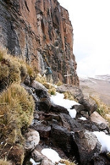
Nevado Mismi is a 5597 metres (18,363 ft) mountain peak of volcanic
origin located in the Andes
mountain range of Peru
. A glacial stream on the Mismi was firmly identified as the most distant source of the Amazon River
in 1996; this finding was confirmed in 2001 and again in 2007.
The waters from Nevado Mismi flow into the Quebradas Carhuasanta
and Apacheta, which flow into the Río Apurímac which is a tributary of the Ucayali
which later joins the Marañón
to form the Amazon proper.
and 700 km southeast of Peru's capital city, Lima
, in the Arequipa Region
. It is one of the highest points of Colca Canyon
. There are several glaciers on the peak.
led a large scale scientific exploration of the Amazon from its mouth to its origin. The “Cousteau Amazon Expedition” cost eleven million dollars and culminated in a six-hour television documentary titled “Cousteau’s Amazon” released in 1983. It offered study information to last years and gave insights into the biology and geology of the largest river system on earth. This expedition was broken into three separate groups and the upper Amazon section was covered by “The Flying Expedition” tasked with exploring the upper third to Arequipa from the river's origin.
Traditionally, explorers and geographers define the origin of a river system by tracking the longest tributaries while heading upstream, as volume can change dramatically from month to month. In a system as complex as the Amazon basin with dozen of streams as candidates in previously poorly mapped areas, no consensus could plausibly be substantiated for some time, and the origin was left to speculation. Half a dozen sites claimed title to “The Origin of the Amazon“ and until 1982 several were in the running.
Using an international team of twelve and bringing in expeditionary specialists from Germany, France, Argentina, Peru and the USA, Jean-Michel Cousteau put together resources and logistics spanning a thousand miles of unknown jungle.
The Upper Amazon expedition (The Flying Expedition) included an Eastern European multi-axled reticulated Land Rover for use on land, a float plane Papagaiu, for air support and reconnaissance, and the Peruvian Air Force offered a high elevation helicopter to reach the upper levels of the Cordillera de Chilca mountain range in Peru
.
Expedition support bases were established in Cuzco, in the mountains, in Arequipa
on the Pacific coast, and high in the Cordillera de Chilca at Caylloma for the quest to find the origin of the Amazon. Many locations were remote, making it necessary to surmount language, terrain and logistical difficulties, as the mountain team made their way up the Río Selinque to the flanks of Nevado Mismi. At this mountain's base, Jean Michael dispatched a team of German alpinists who climbed the 18,000 foot volcano and returned in two days. During their descent, they found melt water dropping into a fissure. This cleft varied from two meters to half a meter wide, angling down the slope. This stream flowed nearly fifty meters before disappearing, emerging again lower down to flow between stones and continue its course. They discovered that within the fissure, the water was deep enough to float a small craft and realized that they were presented with an opportunity. Utilizing pack llamas, kayaker Caril Ridley was brought to the site, and in June 1982, navigating by kayak, became the first person to run the origins of the Amazon. Later expeditions refined our understanding of the river's many origins and its subsequent course to the Atlantic Ocean.
has its glacial source on Nevado Mismi. An expedition of the National Geographic Society
discovered that Carhuasanta
stream flowing into Río Apurímac
originates on the mountain's northern slopes and then runs its course through other tributaries and rivers to help form the main Amazon River. The fact that the headwaters of Río Apurímac are the source of the Amazon River was confirmed by Brazil
ian scientists in 2007, who pointed at Nevado Mismi as the most probable source of the Amazon.
walked the length of the Amazon River, starting at Nevado Mismi, completing the journey in August 2010.
Jason Varndell, Patrick Hutton, Andrew Ellis & James Ellis form another team following the Amazon from source to sea. (http://amazonsourcetosea.wordpress.com)
Volcano
2. Bedrock3. Conduit 4. Base5. Sill6. Dike7. Layers of ash emitted by the volcano8. Flank| 9. Layers of lava emitted by the volcano10. Throat11. Parasitic cone12. Lava flow13. Vent14. Crater15...
origin located in the Andes
Andes
The Andes is the world's longest continental mountain range. It is a continual range of highlands along the western coast of South America. This range is about long, about to wide , and of an average height of about .Along its length, the Andes is split into several ranges, which are separated...
mountain range of Peru
Peru
Peru , officially the Republic of Peru , is a country in western South America. It is bordered on the north by Ecuador and Colombia, on the east by Brazil, on the southeast by Bolivia, on the south by Chile, and on the west by the Pacific Ocean....
. A glacial stream on the Mismi was firmly identified as the most distant source of the Amazon River
Amazon River
The Amazon of South America is the second longest river in the world and by far the largest by waterflow with an average discharge greater than the next seven largest rivers combined...
in 1996; this finding was confirmed in 2001 and again in 2007.
The waters from Nevado Mismi flow into the Quebradas Carhuasanta
Carhuasanta
The Quebrada Carhuasanta is located in the Apurímac Region of Peru. It is known as the headwaters of the Amazon River. The brook is fed by the winter snows of Nevado Mismi, , some 6,400 kilometres from the Atlantic Ocean...
and Apacheta, which flow into the Río Apurímac which is a tributary of the Ucayali
Ucayali
The Ucayali River arises about north of Lake Titicaca, in the Arequipa region of South America. The Amazon River takes its name close to Nauta city , in the confluence among Ucayali and Marañón rivers....
which later joins the Marañón
Marañón River
The Marañón River rises about 160 km to the northeast of Lima, Peru, flows through a deeply-eroded Andean valley in a northwesterly direction, along the eastern base of the Cordillera of the Andes, as far as 5 degrees 36' southern latitude; then it makes a great bend to the northeast, and...
to form the Amazon proper.
Location
Nevado Mismi is about 160 km west of Lake TiticacaLake Titicaca
Lake Titicaca is a lake located on the border of Peru and Bolivia. It sits 3,811 m above sea level, making it the highest commercially navigable lake in the world...
and 700 km southeast of Peru's capital city, Lima
Lima
Lima is the capital and the largest city of Peru. It is located in the valleys of the Chillón, Rímac and Lurín rivers, in the central part of the country, on a desert coast overlooking the Pacific Ocean. Together with the seaport of Callao, it forms a contiguous urban area known as the Lima...
, in the Arequipa Region
Arequipa Region
Arequipa is a region in southwestern Peru. It is bordered by the Ica, Ayacucho, Apurímac and Cusco regions on the north; the Puno Region on the east; the Moquegua Region on the south; and the Pacific Ocean on the west...
. It is one of the highest points of Colca Canyon
Colca Canyon
Colca Canyon is a canyon of the Colca River in southern Peru. Peru's third most-visited tourist destination with about 160,000 visitors annually, it's located about 100 miles northwest of Arequipa...
. There are several glaciers on the peak.
The Cousteau Amazon Expedition
In 1982 Jean-Michel CousteauJean-Michel Cousteau
Jean-Michel Cousteau is a French explorer, environmentalist, educator, and film producer. The first son of ocean explorer Jacques Cousteau, he is the father of Fabien Cousteau and Celine Cousteau.-Biography:...
led a large scale scientific exploration of the Amazon from its mouth to its origin. The “Cousteau Amazon Expedition” cost eleven million dollars and culminated in a six-hour television documentary titled “Cousteau’s Amazon” released in 1983. It offered study information to last years and gave insights into the biology and geology of the largest river system on earth. This expedition was broken into three separate groups and the upper Amazon section was covered by “The Flying Expedition” tasked with exploring the upper third to Arequipa from the river's origin.
Traditionally, explorers and geographers define the origin of a river system by tracking the longest tributaries while heading upstream, as volume can change dramatically from month to month. In a system as complex as the Amazon basin with dozen of streams as candidates in previously poorly mapped areas, no consensus could plausibly be substantiated for some time, and the origin was left to speculation. Half a dozen sites claimed title to “The Origin of the Amazon“ and until 1982 several were in the running.
Using an international team of twelve and bringing in expeditionary specialists from Germany, France, Argentina, Peru and the USA, Jean-Michel Cousteau put together resources and logistics spanning a thousand miles of unknown jungle.
The Upper Amazon expedition (The Flying Expedition) included an Eastern European multi-axled reticulated Land Rover for use on land, a float plane Papagaiu, for air support and reconnaissance, and the Peruvian Air Force offered a high elevation helicopter to reach the upper levels of the Cordillera de Chilca mountain range in Peru
Peru
Peru , officially the Republic of Peru , is a country in western South America. It is bordered on the north by Ecuador and Colombia, on the east by Brazil, on the southeast by Bolivia, on the south by Chile, and on the west by the Pacific Ocean....
.
Expedition support bases were established in Cuzco, in the mountains, in Arequipa
Arequipa
Arequipa is the capital city of the Arequipa Region in southern Peru. With a population of 836,859 it is the second most populous city of the country...
on the Pacific coast, and high in the Cordillera de Chilca at Caylloma for the quest to find the origin of the Amazon. Many locations were remote, making it necessary to surmount language, terrain and logistical difficulties, as the mountain team made their way up the Río Selinque to the flanks of Nevado Mismi. At this mountain's base, Jean Michael dispatched a team of German alpinists who climbed the 18,000 foot volcano and returned in two days. During their descent, they found melt water dropping into a fissure. This cleft varied from two meters to half a meter wide, angling down the slope. This stream flowed nearly fifty meters before disappearing, emerging again lower down to flow between stones and continue its course. They discovered that within the fissure, the water was deep enough to float a small craft and realized that they were presented with an opportunity. Utilizing pack llamas, kayaker Caril Ridley was brought to the site, and in June 1982, navigating by kayak, became the first person to run the origins of the Amazon. Later expeditions refined our understanding of the river's many origins and its subsequent course to the Atlantic Ocean.
National Geographic Society Expedition
In 2001, it was verified that the main headwater of the Amazon RiverAmazon River
The Amazon of South America is the second longest river in the world and by far the largest by waterflow with an average discharge greater than the next seven largest rivers combined...
has its glacial source on Nevado Mismi. An expedition of the National Geographic Society
National Geographic Society
The National Geographic Society , headquartered in Washington, D.C. in the United States, is one of the largest non-profit scientific and educational institutions in the world. Its interests include geography, archaeology and natural science, the promotion of environmental and historical...
discovered that Carhuasanta
Carhuasanta
The Quebrada Carhuasanta is located in the Apurímac Region of Peru. It is known as the headwaters of the Amazon River. The brook is fed by the winter snows of Nevado Mismi, , some 6,400 kilometres from the Atlantic Ocean...
stream flowing into Río Apurímac
Apurímac River
The Apurímac River rises from glacial meltwater of the ridge of Nevado Mismi, a mountain in the Arequipa Province in southern Peru.The Apurímac is the source of the world's largest river system, the Amazon River...
originates on the mountain's northern slopes and then runs its course through other tributaries and rivers to help form the main Amazon River. The fact that the headwaters of Río Apurímac are the source of the Amazon River was confirmed by Brazil
Brazil
Brazil , officially the Federative Republic of Brazil , is the largest country in South America. It is the world's fifth largest country, both by geographical area and by population with over 192 million people...
ian scientists in 2007, who pointed at Nevado Mismi as the most probable source of the Amazon.
Walking the Amazon
Ed StaffordEd Stafford
Ed Stafford is an English explorer and former British-army captain. He was also an expedition leader for extreme conservation company Trekforce.-Biography:...
walked the length of the Amazon River, starting at Nevado Mismi, completing the journey in August 2010.
Jason Varndell, Patrick Hutton, Andrew Ellis & James Ellis form another team following the Amazon from source to sea. (http://amazonsourcetosea.wordpress.com)
External links
- Landscapes of the Soul - photos and story of a solo hike to the Source of the Amazon via the continental divide.