

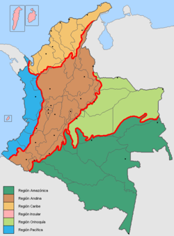
Natural regions of Colombia
Encyclopedia
Colombia
Colombia, officially the Republic of Colombia , is a unitary constitutional republic comprising thirty-two departments. The country is located in northwestern South America, bordered to the east by Venezuela and Brazil; to the south by Ecuador and Peru; to the north by the Caribbean Sea; to the...
can be divided into six very distinct natural region
Natural region
A Natural region is one which is distinguished by its natural features of geography and usually more important, geology. The natural ecology of the region is likely to be significant but one of these factors tends to influence the others....
s. These consist of the Andean region
Andean Region of Colombia
The Andes mountains form the most populated region of Colombia and contain the majority of the country's urban centres. They were also the location of the most significant pre-Columbian indigenous settlement...
, covering the three branches of the Andes
Andes
The Andes is the world's longest continental mountain range. It is a continual range of highlands along the western coast of South America. This range is about long, about to wide , and of an average height of about .Along its length, the Andes is split into several ranges, which are separated...
mountains found in Colombia; the Caribbean region, covering the area adjacent to the Caribbean sea
Caribbean Sea
The Caribbean Sea is a sea of the Atlantic Ocean located in the tropics of the Western hemisphere. It is bounded by Mexico and Central America to the west and southwest, to the north by the Greater Antilles, and to the east by the Lesser Antilles....
; the Pacific region
Pacific Region of Colombia
The Pacific Region is one of the five major natural regions of the Colombian geography. The Pacific region covers the area near the Pacific Ocean in Colombia that contains certain endemic species and ecosystems accompanied by Colombian cultural influence....
adjacent to the Pacific Ocean
Pacific Ocean
The Pacific Ocean is the largest of the Earth's oceanic divisions. It extends from the Arctic in the north to the Southern Ocean in the south, bounded by Asia and Australia in the west, and the Americas in the east.At 165.2 million square kilometres in area, this largest division of the World...
; the Orinoquía region
Orinoquía Region of Colombia
The Orinoquía Region is one of the five natural regions of Colombia. It is also known colloquially as Eastern Plains from the Spanish Llanos Orientales. The region covers most of the area of the departments of Meta, Arauca, Casanare and Vichada. The region is rich in oil and is apt for extensive...
, part of the Llanos
Llanos
The Llanos is a vast tropical grassland plain situated to the east of the Andes in Colombia and Venezuela, in northwestern South America. It is an ecoregion of the Flooded grasslands and savannas Biome....
plains mainly in the Orinoco river basin
Orinoco
The Orinoco is one of the longest rivers in South America at . Its drainage basin, sometimes called the Orinoquia, covers , with 76.3% of it in Venezuela and the remainder in Colombia...
along the border with Venezuela; the Amazon region
Amazon Region of Colombia
The Amazonía Region is a region in southern Colombia. It comprises the departments of Amazonas, Caquetá, Guainía, Guaviare, Putumayo and Vaupés, and covers an area of 403,000 km², 35% of Colombia's total territory...
, part of the Amazon rainforest
Amazon Rainforest
The Amazon Rainforest , also known in English as Amazonia or the Amazon Jungle, is a moist broadleaf forest that covers most of the Amazon Basin of South America...
; and finally the insular region
Insular Region (Colombia)
The Insular Region is considered by some as a geopolitical region of Colombia which comprises the areas outside the continental territories of Colombia and includes the San Andrés y Providencia Department in the Caribbean sea and the Malpelo and Gorgona Islands in the Pacific Ocean...
, comprising islands in both the Atlantic
Atlantic Ocean
The Atlantic Ocean is the second-largest of the world's oceanic divisions. With a total area of about , it covers approximately 20% of the Earth's surface and about 26% of its water surface area...
and Pacific oceans.
Andean Region
The AndesAndes
The Andes is the world's longest continental mountain range. It is a continual range of highlands along the western coast of South America. This range is about long, about to wide , and of an average height of about .Along its length, the Andes is split into several ranges, which are separated...
mountains form the most populous region of Colombia and contain the majority of the country's urban centres. They were also the location of the most significant pre-Columbian indigenous settlement. Beyond the Colombian Massif
Colombian Massif
The Colombian Massif also known colloquially as Nudo de Almaguer refers to a group of mountains within the Andes of south central Colombia. The massif is mainly within the area of the Cauca, Huila, and Nariño Departments...
in the south-western departments of Cauca
Cauca Department
Cauca is a Department of Colombia. Located in the south-western part of the country, facing the Pacific Ocean to the west, the Valle del Cauca Department to the north, Tolima Department to the northeast, Huila Department to the east and the Nariño Department to the south, covering a total area of...
and Nariño
Nariño Department
Nariño is a department of Colombia named after Antonio Nariño. It is in the west of the country, bordering Ecuador and the Pacific Ocean.Its capital is Pasto, other important cities include Tumaco, Ipiales.-Municipalities:# Albán# Aldana# Ancuya...
, the Colombian Andes divide into three branches known as "cordilleras" (from the Spanish
Spanish language
Spanish , also known as Castilian , is a Romance language in the Ibero-Romance group that evolved from several languages and dialects in central-northern Iberia around the 9th century and gradually spread with the expansion of the Kingdom of Castile into central and southern Iberia during the...
for rope): the Cordillera Occidental, running adjacent to the Pacific coast and including the city of Cali
Santiago de Cali
Santiago de Cali , simply referred to as Cali, is a city in western Colombia and the capital of the Valle del Cauca Department. With a population of 2.5 million, Cali is the third largest city in the country. It has one of the fastest growing economies and infrastructure in the country because...
; the Cordillera Central, running up the centre of the country between the Cauca
Cauca River
The Cauca River is a river in Colombia that lies between the Occidental and Central cordilleras. Born in southwestern Colombia near the city of Popayán, it joins the Magdalena River near Pinillos in Bolívar Department, and the combined river eventually flows out into the Caribbean Sea. It has a...
and Magdalena
Magdalena River
The Magdalena River is the principal river of Colombia, flowing northward about through the western half of the country. It takes its name from the biblical figure Mary Magdalene. It is navigable through much of its lower reaches, in spite of the shifting sand bars at the mouth of its delta, as...
river valleys (to the west and east respectively) and including the cities of Medellín
Medellín
Medellín , officially the Municipio de Medellín or Municipality of Medellín, is the second largest city in Colombia. It is in the Aburrá Valley, one of the more northerly of the Andes in South America. It has a population of 2.3 million...
, Manizales
Manizales
Manizales is a city and municipality in central Colombia, capital of Department of Caldas and part of the region of Colombian Coffee-Growers Axis, near the Nevado del Ruiz volcano....
and Pereira
Pereira
Pereira is a common surname in the Portuguese language.It may also refer to:-Places:*Brazil**Pereira Barreto, municipality in São Paulo**Pereiras, municipality in São Paulo*Colombia...
; and the Cordillera Oriental, extending north east to the Guajira Peninsula
Guajira Peninsula
Guajira Peninsula , is a peninsula in northern Colombia and northwestern Venezuela in the Caribbean Sea...
, and including Bogotá
Bogotá
Bogotá, Distrito Capital , from 1991 to 2000 called Santa Fé de Bogotá, is the capital, and largest city, of Colombia. It is also designated by the national constitution as the capital of the department of Cundinamarca, even though the city of Bogotá now comprises an independent Capital district...
, Bucaramanga
Bucaramanga
Bucaramanga is a Colombian city, and capital city of the department of Santander, Colombia. Bucaramanga has the fifth largest city economy and sixth largest population in Colombia, with 1,212,656 people in its metropolitan area...
and Cúcuta
Cúcuta
Cúcuta is a Colombian city, capital of Norte de Santander, in the northeast of the country. Due to its proximity to the Colombian-Venezuelan border, Cúcuta is an important commercial center. The city has the constitutional category of Special District. It is located at the most active...
.
The climate and vegetation of the region vary considerably according to altitude, but as a general rule the land can be divided into the tierra caliente
Tierra caliente
Tierra caliente is a pseudo-climatalogical term used in Latin America to refer to those places within that realm which have a distinctly tropical climate...
(hot land) of river valleys and basins below 1,000 m; the more temperate conditions of the tierra templada
Tierra templada
Tierra templada is a pseudoclimatological term used in Latin America to refer to places within that realm which are either located in the tropics at a moderately high elevation, or are marginally outside the astronomical tropics, producing a somewhat cooler overall climate than that found in the...
(temperate land, approximately 1,000 m to 2,000 m) and tierra fria
Tierra fría
Tierra fría is a pseudoclimatological term used in parts of Latin America to refer to mountain locations within that cultural realm, where high elevation results in a markedly cooler climate than that encountered in the lowlands at a comparable latitude.To a climatologist, the term is inaccurate,...
(cold land, 2,000 m to 3,200 m), which include the most productive land and the majority of the population; and the alpine conditions of the zona forestada (forested zone, 3,200 m to 3,900 m), páramo
Páramo
The term páramo can refer to a variety of ecosystems. Some ecologists describe the páramo broadly as “all high, tropical, montane vegetation above the continuous timberline”. A more narrow term classifies the páramo according to its regional placement - specifically located in “the northern Andes...
s (3,900 m to 4,600 m) and tierra helada
Tierra helada
Tierra helada is a term used in Latin America to refer to the highest places found within the Andes mountains.Tierra helada is for the Montane grasslands and shrublands, Sunis, Punas and Paramos between the Treeline and the Snow line...
(frozen land, 4,600 m and above).
Santander and Antioquia are not departments of the colombian caribbean region, San Andres Islas it is considered a colombian caribbean department, in fact the insular subregion.
Caribbean Region
The Caribbean Region covers 132,218 km² adjacent to the Caribbean SeaCaribbean Sea
The Caribbean Sea is a sea of the Atlantic Ocean located in the tropics of the Western hemisphere. It is bounded by Mexico and Central America to the west and southwest, to the north by the Greater Antilles, and to the east by the Lesser Antilles....
, stretching from the Gulf of Urabá
Gulf of Urabá
The Gulf of Urabá is a gulf on the northern coast of South America. It is part of the Caribbean Sea. It is a long narrow inlet in the coast of Colombia, close to the connection of the continent to the Isthmus of Panama. The town of Turbo lies at the southern end of the Gulf...
in the west to the Guajira Peninsula in the east and including some or all of the departments of Guajira
Department of La Guajira
La Guajira is a department of Colombia. It occupies most of its namesake peninsula, the Guajira Peninsula in the northeast region of the country, facing the Caribbean Sea and Venezuela in the northern most part of South America...
, Bolivar, Atlántico, Cesar, Magdalena, Sucre, Córdoba, Santander and Antioquia.
The region is traversed by a number of rivers heading from the Andean highlands to the sea, including Colombia's principal river, the Magdalena
Magdalena River
The Magdalena River is the principal river of Colombia, flowing northward about through the western half of the country. It takes its name from the biblical figure Mary Magdalene. It is navigable through much of its lower reaches, in spite of the shifting sand bars at the mouth of its delta, as...
, which disgorges at the main port of Barranquilla
Barranquilla
Barranquilla is an industrial port city and municipality located in northern Colombia, near the Caribbean Sea. The capital of the Atlántico Department, it is the largest industrial city and port in the Colombian Caribbean region with a population of 1,148,506 as of 2005, which makes it Colombia's...
. As the area first settled by Europeans, the Caribbean region is also the location of the historic port cities of Santa Marta
Santa Marta
Santa Marta is the capital city of the Colombian department of Magdalena in the Caribbean Region. It was founded in July 29, 1525 by the Spanish conqueror Rodrigo de Bastidas, which makes it the oldest remaining city in Colombia...
and Cartagena
Cartagena, Colombia
Cartagena de Indias , is a large Caribbean beach resort city on the northern coast of Colombia in the Caribbean Coast Region and capital of Bolívar Department...
. However, whilst generally low-lying and humid, the region also includes the Sierra Nevada de Santa Marta
Sierra Nevada de Santa Marta
The Sierra Nevada de Santa Marta is an isolated mountain range apart from the Andes chain that runs through Colombia. Reaching an altitude of 5,700 metres above sea level just 42 km from the Caribbean coast, the Sierra Nevada is the world's highest coastal range...
mountain range and the Guajira Desert
La Guajira Desert
La Guajira Desert is located in the northernmost part of Colombia, north of Bogota, in the La Guajira Department, covering most of La Guajira Peninsula including Venezuelan territory. The area holds immense coal reserves, exploited in a zone known as El Cerrejon...
.
According to the Instituto Geográfico Agustín Codazzi, the Caribbean region can be further divided into seven sub-regions:
- The Guajira PeninsulaGuajira PeninsulaGuajira Peninsula , is a peninsula in northern Colombia and northwestern Venezuela in the Caribbean Sea...
- Sierra Nevada de Santa MartaSierra Nevada de Santa MartaThe Sierra Nevada de Santa Marta is an isolated mountain range apart from the Andes chain that runs through Colombia. Reaching an altitude of 5,700 metres above sea level just 42 km from the Caribbean coast, the Sierra Nevada is the world's highest coastal range...
- Caribbean Savanna
- San Jorge River Valley
- Sinu River Valley
- Mompox Depression
- Gulf of UrabáGulf of UrabáThe Gulf of Urabá is a gulf on the northern coast of South America. It is part of the Caribbean Sea. It is a long narrow inlet in the coast of Colombia, close to the connection of the continent to the Isthmus of Panama. The town of Turbo lies at the southern end of the Gulf...
Pacific Region
The Pacific Region is located on Colombia's western, Pacific coast, and covers an area of 83,170 km². It extends from the Gulf of Urabá in the north to the border with EcuadorEcuador
Ecuador , officially the Republic of Ecuador is a representative democratic republic in South America, bordered by Colombia on the north, Peru on the east and south, and by the Pacific Ocean to the west. It is one of only two countries in South America, along with Chile, that do not have a border...
in the south, and includes part of the departments of Nariño, Cauca, Valle de Cauca and Antioquia, and the whole of the department of Chocó.
This region is distinguished by its high humidity. Precipitation is among the highest in the world, with an average of 4,000 mm per year and some areas that receive as much as 12,000 mm per year. These high levels of precipitation support a number of rivers, including the Atrato River
Atrato River
The Río Atrato is a river of northwestern Colombia. It rises in the slopes of the Western Cordillera and flows almost due north to the Gulf of Urabá , where it forms a large, swampy delta....
, San Juan River
San Juan River (Colombia)
San Juan River is an important river of Colombia. It quoted source is in the Cordillera Occidental and has a length of 380 km...
, Patia River
Patía River
The Patía River is a river in southwestern Colombia. It flows over 400 kilometers to drain into the Pacific Ocean north of Tumaco. The Patía River is the longest river on the Colombian Pacific Coast. The last 90 kilometers is navigable by boat.-Geography:...
, Baudo River and Mira River. The population of the region is mainly Afro-Colombian (it also includes several indigenous settlements), and the economy is based on mining (gold and platinum), timber, fishing, cattle raising and agriculture (particularly the cultivation of borojo, banana
Banana
Banana is the common name for herbaceous plants of the genus Musa and for the fruit they produce. Bananas come in a variety of sizes and colors when ripe, including yellow, purple, and red....
and plantain
Plantain
Plantain is the common name for herbaceous plants of the genus Musa. The fruit they produce is generally used for cooking, in contrast to the soft, sweet banana...
). Buenaventura
Buenaventura, Colombia
Buenaventura is a port city and municipality located in the department of Valle del Cauca, Colombia . Buenaventura is the main port of Colombia in the Pacific Ocean....
is Colombia's main Pacific port.
Orinoquía Region
Also known as the Oriental Plains from the Spanish Llanos Orientales, the Orinoquía Region (Spanish: Región de la Orinoquía) covers most of the area of the departmentsDepartments of Colombia
Colombia is an unitary republic formed by thirty-two departments and a Capital District . Each department has a Governor and a Department Assembly , elected by popular vote for a four-year period. The governor cannot be re-elected in consecutive periods...
of Meta, Arauca, Casanare and Vichada. The region is rich in oil and suitable for extensive ranching but sparsely populated.
Amazon Region
The Amazon Region is a region in southern ColombiaColombia
Colombia, officially the Republic of Colombia , is a unitary constitutional republic comprising thirty-two departments. The country is located in northwestern South America, bordered to the east by Venezuela and Brazil; to the south by Ecuador and Peru; to the north by the Caribbean Sea; to the...
over the Amazon basin
Amazon Basin
The Amazon Basin is the part of South America drained by the Amazon River and its tributaries that drains an area of about , or roughly 40 percent of South America. The basin is located in the countries of Bolivia, Brazil, Colombia, Ecuador, Guyana, Peru, and Venezuela...
. It comprises the departments
Departments of Colombia
Colombia is an unitary republic formed by thirty-two departments and a Capital District . Each department has a Governor and a Department Assembly , elected by popular vote for a four-year period. The governor cannot be re-elected in consecutive periods...
of Amazonas, Caquetá
Department of Caquetá
Caquetá Department is a department of Colombia. Located in the Amazonas region, Caquetá borders with the departments of Cauca and Huila to the west, the department of Meta to the north, the department of Guaviare to the northeast, the department of Vaupés to the east, the departments of Amazonas...
, Guainía, Putumayo, Guaviare and Vaupés.
Insular Region
The Insular Region is considered by some as a sixth region, comprising those areas outside continental Colombia, including the department of San Andrés y Providencia in the Caribbean Sea and the islands of MalpeloMalpelo Island
Malpelo Island is an island located from Colombia's Pacific coast, and approximately from Panama's coast. It has a land area of . It is uninhabited except for a small military post manned by the Colombian Army, which was established in 1986. Visitors need a written permit from the Colombian...
and Gorgona
Gorgona, Colombia
Gorgona is a Colombian island in the Pacific Ocean situated about 50 km off the Colombian Pacific coast and part of the municipality of Guapi in the Department of Cauca. The island is about 9 km long and 2.5 km wide, with a maximum height of 338 m ; with an area of 10 square miles...
in the Pacific Ocean. However, cultural ties are with the respective coastlines.