

National Register of Historic Places listings in Salt Lake City, Utah
Encyclopedia
This is a list of the National Register of Historic Places listings in Salt Lake City, Utah.
This is intended to be a complete list of the properties and districts on the National Register of Historic Places
in Salt Lake City, Utah
, United States
. Latitude and longitude coordinates are provided for many National Register properties and districts; these locations may be seen together in a Google map.
There are 330 properties and districts listed on the National Register in Salt Lake County
, including 6 National Historic Landmark
s. 213 of these sites, including 4 National Historic Landmarks, are located in Salt Lake City, and are listed here; the remaining 117 sites, including 2 National Historic Landmarks, are listed separately
. 4 other sites in the city were once listed, but have since been removed.
This is intended to be a complete list of the properties and districts on the National Register of Historic Places
National Register of Historic Places
The National Register of Historic Places is the United States government's official list of districts, sites, buildings, structures, and objects deemed worthy of preservation...
in Salt Lake City, Utah
Utah
Utah is a state in the Western United States. It was the 45th state to join the Union, on January 4, 1896. Approximately 80% of Utah's 2,763,885 people live along the Wasatch Front, centering on Salt Lake City. This leaves vast expanses of the state nearly uninhabited, making the population the...
, United States
United States
The United States of America is a federal constitutional republic comprising fifty states and a federal district...
. Latitude and longitude coordinates are provided for many National Register properties and districts; these locations may be seen together in a Google map.
There are 330 properties and districts listed on the National Register in Salt Lake County
Salt Lake County, Utah
Salt Lake County is a county located in the U.S. state of Utah. It had a population of 1,029,655 at the 2010 census. Its county seat and largest city is Salt Lake City, the state capital. It occupies Salt Lake Valley, as well as parts of the surrounding mountains, the Oquirrh Mountains to the west...
, including 6 National Historic Landmark
National Historic Landmark
A National Historic Landmark is a building, site, structure, object, or district, that is officially recognized by the United States government for its historical significance...
s. 213 of these sites, including 4 National Historic Landmarks, are located in Salt Lake City, and are listed here; the remaining 117 sites, including 2 National Historic Landmarks, are listed separately
National Register of Historic Places listings in Salt Lake County, Utah
This is a list of the National Register of Historic Places listings in Salt Lake County, Utah.This is intended to be a complete list of the properties and districts on the National Register of Historic Places in Salt Lake County, Utah, United States...
. 4 other sites in the city were once listed, but have since been removed.
Current listings
| Landmark name | Image | Date listed | Location | Summary | |
|---|---|---|---|---|---|
| 1 | 19th Ward Meetinghouse and Relief Society Hall | 168 W. 500 North 40°46′49"N 111°53′42"W |
|||
| 2 | Altadena Apartments | 310 S. 300 East 40°45′44.82"N 111°52′58.16"W |
|||
| 3 | Fortunato Anselmo House | 164 S. 900 East 40°45′56"N 111°51′54"W |
|||
| 4 | George Arbuckle House | 747 E. 1700 South 40°44′2"N 111°52′8"W |
|||
| 5 | Armista Apartments | 555 E. 100 South 40°46′4"N 111°52′2"W |
|||
| 6 | Francis Armstrong House | 667 E. 100 South 40°46′3"N 111°52′16"W |
|||
| 7 | Ashby Apartments | 358 E. 100 South 40°46′1"N 111°52′49"W |
|||
| 8 | Avenues Historic District | Roughly bounded by 1st and 9th Aves. and State and Virginia Sts. 40°46′23"N 111°52′10"W |
|||
| 9 | B'nai Israel Temple | 249 S. 400 East 40°45′48"N 111°52′42"W |
|||
| 10 | Charles Baldwin House | 229 S. 1200 East 40°45′52"N 111°51′21"W |
|||
| 11 | Simon Bamberger House | 623 E. 100 South 40°46′3"N 111°52′19"W |
Simon Bamberger was governor of Utah from 1917-1921. | ||
| 12 | Jeremiah Beattie House | 655 E. 200 South 40°45′56"N 111°52′13"W |
|||
| 13 | Beehive House Beehive House The Beehive House is one of the two official residences of Brigham Young, an early leader of The Church of Jesus Christ of Latter-day Saints . The Beehive House gets its name from the Beehive sculpture atop the house. It was designed by Young's brother-in-law and architect of the Salt Lake... |
 |
67 E. South Temple St. 40°46′8"N 111°53′7"W |
||
| 14 | William F. Beer Estate | 181 B St. and 222 4th Ave. 40°46′24"N 111°52′52"W |
|||
| 15 | Ebenezer Beesley House | 80 W. 200 North 40°46′35"N 111°53′34"W |
|||
| 16 | Benworth-Chapman Apartments and Chapman Cottages | 227 S. 400 East 40°45′51"N 111°52′43"W |
|||
| 17 | Bertolini Block | 143½ W. 200 South 40°45′53"N 111°53′41"W |
|||
| 18 | Best-Cannon House | 1146 S. 900 East 40°44′42"N 111°51′32"W |
|||
| 19 | Bigelow Apartments | 225 S. 400 East 40°45′50"N 111°52′43"W |
|||
| 20 | Broadway Hotel | 222 W. 300 South 40°45′47"N 111°53′49"W |
|||
| 21 | Brooks Arcade | 260 S. State St. 40°45′51"N 111°53′17"W |
|||
| 22 | Building at Rear, 537 West 200 South | Rear, 537 W. 200 South 40°45′52"N 111°54′21"W |
|||
| 23 | Building at 561 West 200 South | 561 W. 200 South 40°45′54"N 111°54′24"W |
|||
| 24 | George M. Cannon House George M. Cannon House The George M. Cannon House, built in 1890, is an historic Late Victorian mansion located at 720 East Ashton Avenue in the Forest Dale area of Salt Lake City, Utah. It was designed by noted Salt Lake architect John A. Headlund for George Mousley Cannon , a member of the Cannon family, a prominent... |
720 E. Ashton Ave. 40°43′10"N 111°52′11"W |
|||
| 25 | Capitol Building Utah State Capitol The Utah State Capitol is the house of government for the U.S. state of Utah. The building houses the chambers of the Utah State Legislature, the offices of the Governor of Utah and Lieutenant Governor of Utah, along with other supporting offices for the Government of Utah... |
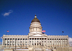 |
Capitol Hill 40°46′40"N 111°50′24"W |
||
| 26 | Capitol Hill Historic District Capitol Hill Historic District (Salt Lake City, Utah) The Capitol Hill Historic District in Salt Lake City, Utah was listed on the National Register of Historic Places in 1982. It was originally roughly bounded by Beck, Main and Wall Sts., 300 N. Victory Rd. and Capitol Blvd., and includes the Utah State Capitol... |
Roughly bounded by Beck, Main and Wall Sts., 300 N. Victory Rd., and Capitol Boulevard; also roughly bounded by 300 North, 400 West, 800 North, Wall St., and 200 West 40°46′43"N 111°53′33"W |
Second set of boundaries represents a boundary increase | ||
| 27 | Carlson Hall | 369 S. University St. 40°45′41"N 111°51′4"W |
|||
| 28 | Cathedral of the Madeleine Cathedral of the Madeleine The Cathedral of the Madeleine is a Roman Catholic church in Salt Lake City, Utah, United States. It was completed in 1909, and currently serves as the cathedral, or mother church, of the Diocese of Salt Lake City. It is the only cathedral in the U.S. under the patronage of St. Mary Magdalene.The... |
 |
331 E. South Temple St. 40°46′12"N 111°52′52"W |
||
| 29 | Centennial Home | 307 Virginia St. 40°46′31"N 111°51′6"W |
|||
| 30 | Central City Historic District | Roughly bounded by South Temple, 900 South, 500 East, and 700 East Sts.; also roughly bounded by South Temple, 400 South, 700 East, and 1100 East 40°45′33"N 111°52′24"W |
Second set of boundaries represents a boundary increase | ||
| 31 | Central Warehouse Central Warehouse (Salt Lake City, Utah) The Central Warehouse in Salt Lake City, Utah was built in 1929. It was listed on the National Register of Historic Places in 1982.... |
520 W. 200 South 40°45′55"N 111°54′20"W |
|||
| 32 | Chapman Branch Library | 577 S. 900 West 40°45′24"N 111°54′58"W |
|||
| 33 | Isaac Chase Mill | Liberty Park, 600 East 40°44′36"N 111°52′25"W |
|||
| 34 | City Creek Canyon Historic District | Bounded by Capitol Boulevard, A St., 4th Ave. and Canyon Rd. 40°46′49"N 111°52′59"W |
|||
| 35 | Isaac C. and Dorothy S. Clark House | 1430 E. Federal Way 40°46′5"N 111°50′57"W |
|||
| 36 | Clift Building | 272 S. Main St. 40°45′47"N 111°53′27"W |
|||
| 37 | Cluff Apartments | 1270-1280 E. 200 South 40°45′53"N 111°51′12"W |
|||
| 38 | Henry A. and Tile S. Cohn House | 1369 E. Westminister Ave. 40°43′46"N 111°51′2"W |
|||
| 39 | Congregation Montefiore | 355 S. 300 East 40°45′41"N 111°52′53"W |
|||
| 40 | Congregation Sharey Tzedek Synagogue | 833 S. 200 East 40°45′4"N 111°53′3"W |
|||
| 41 | Continental Bank Building | 200 S. Main St. 40°45′53"N 111°53′27"W |
|||
| 42 | Converse Hall | 1840 S. 1300 East 40°43′55"N 111°51′14"W |
|||
| 43 | Cornell Apartments | 101 S. 600 East 40°46′1"N 111°52′8"W |
|||
| 44 | Corona Apartments | 335 S. 200 East 40°45′43"N 111°53′3"W |
|||
| 45 | Council Hall Salt Lake City Council Hall The Salt Lake City Council Hall is currently home to offices for the Utah Office of Tourism and The Utah Film Commission and is located on Capitol Hill in Salt Lake City, Utah... |
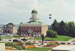 |
Capitol Hill at head of State St. 40°46′33"N 111°53′13"W |
||
| 46 | Almon A. Covey House | 1211 E. 100 South 40°46′3"N 111°51′21"W |
|||
| 47 | Hyrum T. Covey House | 1229 E. 100 South 40°46′3"N 111°51′19"W |
|||
| 48 | Cramer House | 241 Floral St. 40°45′50"N 111°53′16"W |
|||
| 49 | Crown Cleaning and Dyeing Company Building | 1989 S. 1100 East 40°43′40"N 111°51′31"W |
|||
| 50 | William Culmer House | 33 C St. 40°46′14"N 111°52′43"W |
Now the Sacred Heart Center of the Roman Catholic Diocese of Salt Lake City Roman Catholic Diocese of Salt Lake City The Roman Catholic Diocese of Salt Lake City, officially in Latin Dioecesis Civitatis Lacus Salsi, is a diocese of the Roman Catholic Church in the United States. It comprises the entire state of Utah. Also known as the Utah Catholic Church or the See of Salt Lake City, its mother church is the... |
||
| 51 | Byron Cummings House Byron Cummings House The Byron Cummings House at 936 E. 1700 South, in Salt Lake City, Utah, was built in 1891. It was listed on the National Register of Historic Places in 1983.It is significant in part for association with Byron Cummings, known as "the father... |
936 E. 1700 South 40°44′0"N 111°51′49"W |
|||
| 52 | Genevieve & Alexander Curtis House | 1119 E. Westminster Ave. 40°43′46"N 111°51′32"W |
|||
| 53 | Daft Block | 128 S. Main St. 40°45′59"N 111°53′26"W |
|||
| 54 | Davis Deaconess Home | 347 S. 400 East 40°45′41"N 111°52′44"W |
|||
| 55 | Denver and Rio Grande Railroad Station Denver and Rio Grande Western Depot (Salt Lake City) The Denver and Rio Grande Western Depot, commonly referred to as the Rio Grande Depot, in a former railroad station on the western edge of downtown Salt Lake City, Utah. The depot was constructed by the Denver and Rio Grande Western Railroad in 1910, and was listed on the National Register of... |
300 South and Rio Grande 40°45′46"N 111°54′14"W |
|||
| 56 | Devereaux House | 334 W. South Temple St. 40°46′13"N 111°54′2"W |
|||
| 57 | Harper J. Dininny House | 925 E. Logan Ave. 40°44′4"N 111°51′49"W |
|||
| 58 | Henry Dinwoody House | 411 E. 100 South 40°46′4"N 111°52′42"W |
|||
| 59 | Exchange Place Historic District | Exchange Place and S. Main St. 40°45′38"N 111°53′22"W |
|||
| 60 | J. Leo Fairbanks House | 1228 Bryan Ave. 40°44′8"N 111°51′19"W |
|||
| 61 | Felt Electric | 165 S. Regent St. 40°45′55"N 111°53′20"W |
|||
| 62 | Fifth Ward Meetinghouse | 740 S. 300 West 40°46′50"N 111°54′25"W |
|||
| 63 | Firestation No. 8 | 258 S. 1300 East 40°45′49"N 111°51′13"W |
|||
| 64 | First Church of Christ, Scientist First Church of Christ, Scientist (Salt Lake City, Utah) The former First Church of Christ, Scientist, located at 352 East 300 South in Salt Lake City, Utah, in the United States is an historic structure that on July 30, 1976, was added to the National Register of Historic Places... |
352 E. 300 South 40°45′45"N 111°52′49"W |
|||
| 65 | First Methodist Episcopal Church | 200 S. 200 East 40°46′24"N 111°54′29"W |
|||
| 66 | First National Bank | 163 S. Main St. 40°45′56"N 111°53′24"W |
|||
| 67 | First Security Bank Building | 405 S. Main St. 40°45′36"N 111°53′23"W |
|||
| 68 | Ford Motor Company Service Building | 280 S. 400 West 40°45′47"N 111°54′8"W |
|||
| 69 | Forest Dale Historic District Forest Dale Historic District The Forest Dale Historic District is located in the southeastern part of Salt Lake City, Utah and is roughly bounded by 700 East, Interstate 80, Commonwealth Avenue, and 900 East... |
Roughly bounded by 700 East, Interstate 80 Interstate 80 Interstate 80 is the second-longest Interstate Highway in the United States, following Interstate 90. It is a transcontinental artery running from downtown San Francisco, California to Teaneck, New Jersey in the New York City Metropolitan Area... , Commonwealth Ave., and 900 East 40°43′19.92"N 111°52′5.23"W |
|||
| 70 | Fort Douglas Fort Douglas, Utah Camp Douglas was established in October 1862 as a small military garrison about three miles east of Salt Lake City, Utah, for the purpose of protecting the overland mail route and telegraph lines along the Central Overland Route. In 1878, the post was renamed Fort Douglas. The fort was officially... |
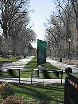
 |
Fort Douglas Military Reservation 40°45′52"N 111°49′58"W |
||
| 71 | J. A. Fritsch Block | 158 E. 200 South 40°45′53"N 111°53′7"W |
|||
| 72 | W.P. Fuller Paint Company Office and Warehouse | 404 W. 400 South 40°45′40"N 111°54′8"W |
|||
| 73 | General Engineering Company Building | 159 W. Pierpont Ave. 40°45′49"N 111°53′44"W |
|||
| 74 | Gibbs-Thomas House | 137 N. West Temple St. 40°46′22"N 111°53′36"W |
|||
| 75 | Gilmer Park Historic District | Roughly bounded by 1100 East, 900 South, 1300 East, and Harv Ave. 40°44′48"N 111°51′21"W |
|||
| 76 | Granite LDS Stake Tabernacle | 2005 S. 900 East 40°43′35"N 111°51′50"W |
|||
| 77 | Granite Lumber Company Building | 1090 E. 2100 South 40°43′31"N 111°51′33"W |
|||
| 78 | Greenwald Furniture Company Building | 35 W. 300 South 40°45′45"N 111°53′29"W |
|||
| 79 | Nels G. Hall House | 1340 2nd Ave. 40°46′18"N 111°50′56"W |
|||
| 80 | Nephi J. Hansen House | 1797 S. 1400 East 40°43′51"N 111°51′0"W |
|||
| 81 | Harris Apartments | 836 S. 500 East 40°45′3"N 111°52′34"W |
|||
| 82 | William Hawk Cabin | 458 N. 300 West 40°46′54"N 111°53′53"W |
|||
| 83 | Henderson Block | 375 W. 200 South 40°45′52"N 111°54′5"W |
|||
| 84 | Thomas and Mary Hepworth House | 725 W. 200 North 40°46′25"N 111°54′40"W |
|||
| 85 | Herald Building | 165-169 S. Main St. 40°45′56"N 111°53′24"W |
|||
| 86 | Highland Park Historic District | Roughly bounded by Parkway Ave., 1500 East, 2700 South, and Elizabeth St. 40°42′56"N 111°51′7"W |
|||
| 87 | Lewis S. Hills House Lewis S. Hills House (126 S. 200 West) The Lewis S. Hills House at 126 S. 200 West, Salt Lake City, Utah, was built in 1885. It also has been known as Hogar Hotel. It was listed on the National Register of Historic Places in 1977.... |
126 S. 200 West 40°46′0"N 111°53′47"W |
|||
| 88 | Lewis S. Hills House | 425 E. 100 South 40°46′3"N 111°52′41"W |
|||
| 89 | Hollywood Apartments | 234 E. 100 South 40°46′1"N 111°53′2"W |
|||
| 90 | Holy Trinity Greek Orthodox Church |  |
279 S. 200 West 40°45′49"N 111°53′54"W |
||
| 91 | Hotel Albert | 121 S. West Temple St. 40°46′0"N 111°53′35"W |
|||
| 92 | Hotel Utah Joseph Smith Memorial Building The Joseph Smith Memorial Building is named in honor of Joseph Smith, Jr., the founder of the Latter Day Saint movement. It is located on the corner of Main Street and South Temple in Salt Lake City. Previously the Hotel Utah, it is now an administrative building... |
 |
South Temple and Main St. 40°46′11"N 111°53′23"W |
Now the Joseph Smith Memorial Building | |
| 93 | Hotel Victor | 155 W. 200 South 40°45′53"N 111°53′42"W |
|||
| 94 | Immanuel Baptist Church | 401 E. 200 South 40°46′4"N 111°53′0"W |
|||
| 95 | Independent Order of Odd Fellows Hall Independent Order of Odd Fellows Hall (Salt Lake City, Utah) The Independent Order of Odd Fellows Hall in Salt Lake City, Utah, also known as the I.O.O.F. Hall, was built in 1891. It was designed by George F. Costersian in Richardsonian Romanesque style.... |
26 W. Market St. 40°45′41"N 111°53′30"W |
|||
| 96 | Irving Junior High School | 1179 E. 2100 South 40°43′34"N 111°51′25"W |
|||
| 97 | Ivanhoe Apartments | 417 E. 300 South 40°45′47"N 111°52′41"W |
|||
| 98 | Japanese Church of Christ | 268 W. 100 South 40°46′3"N 111°53′54"W |
|||
| 99 | John W. Judd House | 918 E. Logan Ave. 40°44′3"N 111°51′50"W |
|||
| 100 | Judge Building | 8 E. 300 South 40°45′46"N 111°53′24"W |
|||
| 101 | Emanuel Kahn House | 678 E. South Temple St. 40°46′9"N 111°52′15"W |
Now the Anniversary Inn bed and breakfast Bed and breakfast A bed and breakfast is a small lodging establishment that offers overnight accommodation and breakfast, but usually does not offer other meals. Since the 1980s, the meaning of the term has also extended to include accommodations that are also known as "self-catering" establishments... |
||
| 102 | Karrick Block | 236 S. Main St. 40°45′49"N 111°53′26"W |
|||
| 103 | Kearns Building | 132 S. Main St. 40°45′58"N 111°53′27"W |
|||
| 104 | Thomas Kearns Mansion and Carriage House Utah Governor's Mansion The Utah Governor's Mansion is the official residence of the Governor of Utah and family. It is located at 603 E. South Temple St., Salt Lake City, Utah.... |
603 E. South Temple St. 40°46′11"N 111°52′23"W |
Serves as the Utah Governor's Mansion | ||
| 105 | David Keith Mansion and Carriage House | 529 E. South Temple St. 40°46′11"N 111°52′30"W |
|||
| 106 | Keith-O'Brien Building | 242-256 S. Main St. 40°45′49"N 111°53′27"W |
|||
| 107 | Albert H. Kelly House | 418 S. 200 West 40°45′36"N 111°53′49"W |
|||
| 108 | John B. Kelly House | 422 S. 200 West 40°45′36"N 111°53′49"W |
|||
| 109 | Keyser-Cullen House | 941 E. 500 South 40°45′32"N 111°51′48"W |
|||
| 110 | Malcolm and Elizabeth Keyser House | 381 E. 11th Ave. 40°46′57.072"N 111°52′40.836"W |
|||
| 111 | Ladies Literary Club Clubhouse | 850 E. South Temple St. 40°46′10"N 111°51′58"W |
|||
| 112 | John C. and Mary Landenberger House | 58 N. Virginia St. 40°46′11"N 111°51′48"W |
|||
| 113 | James and Susan R. Langton House | 648 E. 100 South 40°46′1"N 111°52′19"W |
|||
| 114 | Lefler-Woodman Building | 859 E. 900 South 40°45′0"N 111°51′55"W |
|||
| 115 | Dr. David and Juanita Lewis House | 1403 E. Westminster Ave. 40°43′45"N 111°51′1"W |
|||
| 116 | Liberty Park Liberty Park Liberty Park is a popular public urban park in Salt Lake City, Utah. It is the city's second-largest public park, at , being surpassed only by Sugarhouse Park which has... |
 |
Roughly bounded by 500 East, 700 East, 900 South, and 1300 South 40°44′44.55"N 111°52′26.1"W |
||
| 117 | Lincoln Arms Apartments | 242 E. 100 South 40°46′1"N 111°52′59"W |
|||
| 118 | Lollin Block | 238 S. Main St. 40°45′51"N 111°53′27"W |
|||
| 119 | Henry Luce House | 921 E. 1700 South 40°44′1"N 111°51′50"W |
|||
| 120 | Walter C. Lyne House | 1135 E. South Temple St. 40°46′11"N 111°51′28"W |
|||
| 121 | Mabry-Van Pelt House | 946 E. 1700 South 40°44′0"N 111°51′47"W |
|||
| 122 | Millard F. Malin House | 133 S. 400 East 40°45′51"N 111°52′43"W |
|||
| 123 | James G. McAllister House | 306 Douglas St. 40°45′45"N 111°51′17"W |
|||
| 124 | McCornick Building | 10 W. 100 South 40°46′3"N 111°53′26"W |
|||
| 125 | Alfred W. McCune Mansion Alfred McCune Home The Alfred McCune Home is one of the mansions on Capitol Hill in Salt Lake City, Utah, from around the turn of the 20th century. Built for Alfred W. McCune on the inclined south side of Capitol Hill at the northeast corner of 200 North and Main Street, the mansion has 21 rooms and is on the... |
200 N. Main St. 40°46′26"N 111°53′24"W |
|||
| 126 | J. G. McDonald Chocolate Company Building | 155-159 W. 300 South 40°45′45"N 111°53′44"W |
|||
| 127 | McIntyre Building | 68-72 S. Main St. 40°46′4"N 111°53′26"W |
|||
| 128 | McIntyre House | 259 7th Ave. 40°46′39"N 111°52′48"W |
|||
| 129 | Joseph and Marie N. McRae House | 452 E. 500 South 40°45′30"N 111°52′38"W |
|||
| 130 | Frederick A.E. Meyer House | 929 E. 200 South 40°45′55"N 111°51′49"W |
|||
| 131 | Alexander Mitchell House Alexander Mitchell House (Salt Lake City, Utah) The Alexander Mitchell House at 1620 S. 1000 East, in Salt Lake City, Utah, was built in 1891. It was listed on the National Register of Historic Places in 1983 for its architecture, which is Victorian Eclectic, Late Victorian, and other.... |
1620 S. 1000 East 40°44′3"N 111°51′43"W |
|||
| 132 | Richard Vaughen Morris House | 314 Quince St. 40°46′34"N 111°53′40"W |
|||
| 133 | Morrison-Merrill Lumber Company Office and Warehouse | 205 N. 400 West 40°46′26"N 111°54′7"W |
|||
| 134 | Mountain States Telephone and Telegraph Co. Garage | 1075 E. Hollywood Ave. 40°43′39"N 111°51′36"W |
|||
| 135 | William A. Nelden House | 1172 E. 100 South 40°46′1"N 111°51′23"W |
|||
| 136 | Nelson-Beesley House | 533 11th Ave. 40°46′56"N 111°52′22"W |
|||
| 137 | Carl M. Neuhausen House | 1265 E. 100 South 40°46′4"N 111°51′15"W |
|||
| 138 | New York Hotel | 42 Post Office Pl. 40°45′42"N 111°53′31"W |
|||
| 139 | Old Clock at Zion's First National Bank | Southwestern corner of 100 South and Main St. 40°46′1"N 111°53′27"W |
|||
| 140 | Old Pioneer Fort Site | 400 South and 200 West 40°45′43"N 111°54′1"W |
|||
| 141 | Oregon Shortline Railroad Company Building | 126-140 Pierpont Ave. 40°45′51"N 111°53′39"W |
|||
| 142 | Oquirrh School | 350 S. 400 East 40°45′41.436"N 111°52′49.692"W |
|||
| 143 | Frank M. Orem House | 274 S. 1200 East 40°45′48"N 111°51′24"W |
|||
| 144 | Orpheum Theatre | 46 W. 200 South 40°45′55"N 111°53′32"W |
|||
| 145 | Ottinger Hall | 233 Canyon Rd. 40°46′32"N 111°53′7"W |
|||
| 146 | Peter Pan Apartments | 446 E. 300 South 40°45′44.82"N 111°52′41.412"W |
|||
| 147 | Pacific Northwest Pipeline Building | 315 E. 200 South 40°45′56"N 111°52′54"W |
|||
| 148 | Park Hotel | 422-432 W. 300 South 40°45′47"N 111°54′10"W |
|||
| 149 | Clifford R. Pearsall House | 950 E. Logan Ave. 40°44′3"N 111°51′46"W |
|||
| 150 | Piccardy Apartments | 115 S. 300 East 40°45′59.976"N 111°52′56.172"W |
|||
| 151 | Peery Hotel | 270-280 S. West Temple, 102-120 W. 300 South 40°45′47"N 111°53′36"W |
|||
| 152 | John Platts House | 364 Quince St. 40°46′40"N 111°53′39"W |
|||
| 153 | Lorenzo and Emma Price House and Barn | 1205 E. 1300 South 40°44′31"N 111°51′20"W |
|||
| 154 | Lewis A. Ramsey House | 128 S. 1000 East 40°45′59"N 111°51′44"W |
|||
| 155 | Richardson-Bower Building | 1019 E. 2100 South 40°43′32"N 111°51′41"W |
|||
| 156 | Rowland Hall-St. Mark's School Rowland Hall-St. Mark's School Rowland Hall is a college preparatory school with approximately 1,000 students on two campuses in Salt Lake City, Utah.-General information:Rowland Hall traces its roots to St. Mark's School, which was founded in Salt Lake City by Episcopal Bishop Daniel Sylvester Tuttle in 1867. In support of... |
205 1st Ave. 40°46′17"N 111°52′55"W |
|||
| 157 | Jonathan C. and Eliza K. Royle House | 635 E. 100 South 40°46′3"N 111°52′21"W |
|||
| 158 | Eliza Gray Rumel House | 358 S. 500 East 40°45′41"N 111°52′35"W |
|||
| 159 | St. Mark's Episcopal Cathedral St. Mark's Cathedral, Salt Lake City St. Mark's Episcopal Cathedral located at 231 E. 100 South in Salt Lake City, Utah is the cathedral church of the Diocese of Utah in the Episcopal Church in the United States of America. Built in 1871, it is the third oldest Episcopal Cathedral in the United States and the oldest continuously used... |
 |
231 E. 100 South 40°46′4"N 111°53′0"W |
||
| 160 | Salt Lake City and County Building Salt Lake City and County Building The Salt Lake City and County Building, usually called the "City-County Building", is the seat of government for Salt Lake City, Utah. The historic landmark formerly housed offices for Salt Lake County government as well, hence the name.- History :... |
 |
451 Washington Sq. 40°45′35"N 111°53′9"W |
||
| 161 | Salt Lake City East Side Historic District | Roughly bounded by 400 South, University St., 900 South, and 700 East 40°45′18.74"N 111°51′44.74"W |
|||
| 162 | Salt Lake City Public Library Old Hansen Planetarium The Old Hansen Planetarium at 15 South State Street in Salt Lake City, Utah has served many functions throughout its history. Originally built in 1904 as the Salt Lake City Public Library, the building was renovated in 1965 to become the Hansen Planetarium... |
15 S. State St. 40°46′7"N 111°53′13"W |
Housed the Hansen Planetarium 1965–2003, O.C. Tanner Jewelry O.C. Tanner (company) O.C. Tanner Co., named after founder Obert C. Tanner, is a human resource consulting and services company that designs and helps implement employee recognition programs for clients in the U.S., Canada, and Europe... since 2009 |
||
| 163 | Salt Lake Engineering Works-Bogue Supply Company Building | 741 W. 400 South 40°45′37"N 111°54′46"W |
|||
| 164 | Salt Lake Hardware Company Warehouse | 155 N. 400 West 40°46′19"N 111°54′9"W |
|||
| 165 | Salt Lake Northwest Historic District | Roughly bounded by 1100 West, 600 North, 500 West, and North Temple 40°46′48"N 111°54′58"W |
|||
| 166 | Salt Lake Stamp Company Building | 43 W. 200 South 40°45′45"N 111°53′30"W |
|||
| 167 | Salt Lake Stock and Mining Exchange Building | 39 Exchange Place 40°45′42"N 111°53′21"W |
|||
| 168 | Salt Lake Union Pacific Railroad Station Salt Lake City Union Pacific Depot The Salt Lake City Union Pacific Depot is a spacious building on the western edge of downtown Salt Lake City, Utah. Built from 1908 to 1909, it harkens back to a more prosperous era in the history of American railroad travel... |
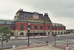 |
South Temple at 400 West 40°46′10"N 111°54′9"W |
||
| 169 | Sampson Apartments | 276 E. 300 South 40°45′45.99"N 111°52′59.84"W |
|||
| 170 | Sarah Daft Home for the Aged | 737 S. 1300 East 40°45′12"N 111°52′36"W |
|||
| 171 | Seventh-day Adventist Meetinghouse and School | 1840 S. 800 East 40°43′47"N 111°52′4"W |
|||
| 172 | Silver Brothers' Iron Works Office and Warehouse | 550 W. 700 South 40°45′16"N 111°54′20"W |
|||
| 173 | Smith Apartments | 228 S. 300 East 40°45′51"N 111°52′45"W |
|||
| 174 | George Albert Smith House | 1302 E. Yale Ave. 40°44′44"N 111°51′11"W |
|||
| 175 | Smith-Bailey Drug Company Building | 171 W. 200 South 40°45′53"N 111°53′45"W |
|||
| 176 | South Temple Historic District South Temple Historic District The South Temple Historic District is a historic district that was the first to be listed in the Salt Lake City Register in 1976, and was listed on the National Register of Historic Places in 1982.... |
100 E. to 1350 E. South Temple St. 40°46′10"N 111°52′11"W |
|||
| 177 | Sprague Branch of the Salt Lake City Public Library | 2131 S. Highland Dr. 40°43′30"N 111°51′30"W |
|||
| 178 | Stratford Hotel | 175 E. 200 South 40°45′55"N 111°53′6"W |
|||
| 179 | Sugar House LDS Ward Building | 1950 S. 1200 East 40°43′40"N 111°51′24"W |
|||
| 180 | Sugar House Monument | 1100 East and 2100 South 40°43′32"N 111°51′34"W |
|||
| 181 | Sweet Candy Company Building | 224 S. 200 West 40°45′52"N 111°53′48"W |
|||
| 182 | Temple Square Temple Square Temple Square is a ten acre complex located in the center of Salt Lake City, Utah, owned by The Church of Jesus Christ of Latter-day Saints . In recent years, the usage of the name has gradually changed to include several other church facilities immediately adjacent to Temple Square... |
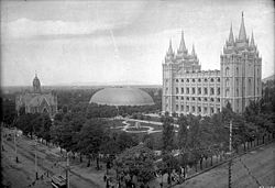 |
Temple Square 40°46′14"N 111°53′29"W |
||
| 183 | Tenth Ward Square | 400 South and 800 East 40°45′37"N 111°52′5"W |
|||
| 184 | Third Presbyterian Church Parsonage | 1068 E. Blaine Ave. 40°43′56"N 111°51′35"W |
|||
| 185 | Tracy Loan and Trust Company Building | 151 S. Main St. 40°45′57"N 111°53′24"W |
|||
| 186 | Trinity A.M.E. Church | 239 E. 600 South 40°45′24"N 111°53′1"W |
|||
| 187 | Frank M. and Susan E. Ulmer House | 1458 S. 1300 East 40°44′16"N 111°51′12"W |
|||
| 188 | University Neighborhood Historic District | Roughly bounded by 500 South, South Temple, 1100 East and University St. 40°46′23"N 111°51′20"W |
|||
| 189 | University of Utah Circle University of Utah Circle The University of Utah Circle, also known as Presidents Circle, is located on the campus of the University of Utah in Salt Lake City, Utah. It was listed on the National Register of Historic Places in 1978 as a historic district.-History:... |
 |
University of Utah University of Utah The University of Utah, also known as the U or the U of U, is a public, coeducational research university in Salt Lake City, Utah, United States. The university was established in 1850 as the University of Deseret by the General Assembly of the provisional State of Deseret, making it Utah's oldest... campus 40°45′54"N 111°50′59"W |
||
| 190 | US Post Office-Sugar House | 2155 S. Highland Dr. 40°43′27"N 111°51′30"W |
|||
| 191 | Utah Commercial and Savings Bank Building | 22 E. 100 South 40°46′1"N 111°53′23"W |
|||
| 192 | Utah Slaughter Company Warehouse | 370 W. 100 South 40°46′3"N 111°54′5"W |
|||
| 193 | Utah State Fair Grounds | 1000 West and North Temple Sts. 40°46′45"N 111°56′23"W |
|||
| 194 | Utah State Liquor Agency No. 22 | 1938 S. 1100 East 40°43′41"N 111°51′31"W |
|||
| 195 | Veterans Administration Hospital | 401 E. 12th Ave. 40°47′4"N 111°52′40"W |
|||
| 196 | Walker Bank Building Walker Center Walker Center is a skyscraper in Salt Lake City, Utah, United States. It was opened on December 9, 1912; taking a little over a year to be built. At the time of its completion, it stood as the tallest building between Chicago and San Francisco... |
175 S. Main St. 40°45′55"N 111°53′24"W |
|||
| 197 | Warehouse District | 200 South and Pierpont Ave. between 300 and 400 West 40°45′47"N 111°54′10"W |
|||
| 198 | Wasatch Springs Plunge | 840 N. 300 West 40°47′21"N 111°53′57"W |
|||
| 199 | Charles H. Weeks House | 935 E. Logan Ave. 40°44′4"N 111°51′48"W |
|||
| 200 | Wells Historic District | Roughly bounded by 700 East, State St., 1300 South, and 2100 South 40°44′0.76"N 111°52′47.09"W |
|||
| 201 | Westminster College President's House | 1733 S. 1300 East 40°43′59"N 111°51′9"W |
|||
| 202 | Westmoreland Place Historic District | Roughly bounded by 1300 South, 1500 East, Sherman Ave. & 1600 East Sts. 40°44′27"N 111°50′48"W |
|||
| 203 | Nelson Wheeler Whipple House | 564 W. 400 North 40°45′11"N 111°53′58"W |
|||
| 204 | John M. Whitaker House | 975 Garfield Ave. 40°43′48"N 111°51′43"W |
|||
| 205 | Woodruff Villa | 1622 S. 500 East 40°44′3"N 111°52′34"W |
|||
| 206 | Asahel Hart Woodruff House | 1636 S. 500 East 40°44′2"N 111°52′34"W |
|||
| 207 | Wilford Woodruff Farm House | 1604 S. 500 East 40°44′4"N 111°52′34"W |
|||
| 208 | Woodruff-Riter House Woodruff-Riter-Stewart Home thumb|left|300px|Woodruff-Riter-Stewart Home in 2002.The Woodruff-Riter-Stewart Home is a mansion on Capitol Hill in Salt Lake City, Utah. It sits on the corner of State Street and 200 North on the south slope of Capitol Hill.Originally built for Edward D... |
225 N. State St. 40°46′27"N 111°53′16"W |
|||
| 209 | Yalecrest Historic District | Roughly bounded by Sunnyside Ave. (840 South) to 1300 South, and 1300 East to 1800 East 40°44′48.4"N 111°50′43"W |
|||
| 210 | Thomas Yardley House | 955 E. Logan Ave. 40°44′4"N 111°51′45"W |
|||
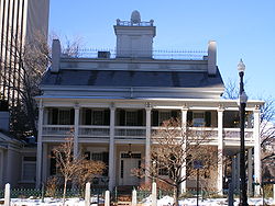
| 211 | Brigham Young Complex Brigham Young Complex The Brigham Young Complex is the collective name given in the U.S. National Historic Landmark program to a set of two houses in Salt Lake City, Utah. These houses were the residence of Brigham Young from 1852 until his death in 1877... |
 |
63-67 E. South Temple St. 40°46′11"N 111°53′17"W |
||
| 212 | Z.C.M.I. Cast Iron Front | 15 S. Main St. 40°46′8"N 111°53′24"W |
|||
| 213 | ZCMI General Warehouse | 230 S. 500 West 40°45′52"N 111°54′19"W |
Former listings
| Landmark name | Image | Date delisted | Location | Summary | |
|---|---|---|---|---|---|
| 1 | Building at 592-98 West 200 South | 592-98 W. 200 South 40°45′54"N 111°54′26"W |
Listed August 17, 1982; removed September 3, 2009 | ||
| 2 | Redman Van and Storage Company Building | 1240 East 2100 South | Listed July 11, 2003; removed from NRHP February 21, 2007 | ||
| 3 | Tampico Restaurant | 169 Regent St. 40°45′55"N 111°53′20"W |
Listed December 27, 1982; removed February 1, 1995 | ||
| 4 | Technical High School | 241 N. 300 West 40°46′29"N 111°54′6"W |
Listed February 19, 1980; removed May 15, 2001 |
See also
- List of National Historic Landmarks in Utah
- National Register of Historic Places listings in Utah