

National Register of Historic Places listings in Charleston, South Carolina
Encyclopedia
This is intended to be a complete list of the properties and districts on the National Register of Historic Places
National Register of Historic Places
The National Register of Historic Places is the United States government's official list of districts, sites, buildings, structures, and objects deemed worthy of preservation...
in Charleston
Charleston, South Carolina
Charleston is the second largest city in the U.S. state of South Carolina. It was made the county seat of Charleston County in 1901 when Charleston County was founded. The city's original name was Charles Towne in 1670, and it moved to its present location from a location on the west bank of the...
, South Carolina
South Carolina
South Carolina is a state in the Deep South of the United States that borders Georgia to the south, North Carolina to the north, and the Atlantic Ocean to the east. Originally part of the Province of Carolina, the Province of South Carolina was one of the 13 colonies that declared independence...
, United States
United States
The United States of America is a federal constitutional republic comprising fifty states and a federal district...
. The locations of National Register properties and districts for which the latitude and longitude coordinates are included below, may be seen in a Google map.
There are 184 properties and districts listed on the National Register in Charleston County
Charleston County, South Carolina
Charleston County is a county located in the U.S. state of South Carolina. According to a 2005 U.S. Census Bureau estimate, its population was 330,368. Its county seat is Charleston. It is the third-most populous county in the state . Charleston County was created in 1901 by an act of the South...
, including 43 National Historic Landmark
National Historic Landmark
A National Historic Landmark is a building, site, structure, object, or district, that is officially recognized by the United States government for its historical significance...
s. The city of Charleston is the location of 90 of these properties and districts, including 34 of the National Historic Landmarks; they are listed here, while the 96 properties and districts in the remaining parts of the county are listed separately. Another property in Charleston was once listed but has been removed. Three properties and districts — the Ashley River Historic District
Ashley River Historic District
Ashley River Historic District is a historic district near Charleston, South Carolina and North Charleston.It was listed on the National Register of Historic Places in 1994.The SC DAH summary is here....
, Ashley River Road
South Carolina Highway 61
South Carolina Highway 61 is a long highway in the U.S. state of South Carolina. The highway is designated on an east–west direction, from U.S. Route 78 near Branchville to South Carolina Highway 30 in Charleston. The portion of Highway 61 from Church Creek Bridge and ten miles north is...
, and the Secessionville Historic District — are split between the city and the other parts of the county, and are thus included on both lists.
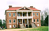
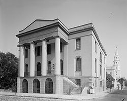
Current listings
| Landmark name | Image | Date listed | Location | Neighborhood | Summary | |
|---|---|---|---|---|---|---|
| 1 | 48 Elizabeth St. 32°47′29"N 79°56′6"W |
Peninsula | ||||
| 2 | .jpg) |
456 King St. 32°47′22"N 79°56′17"W |
Peninsula | |||
| 3 | Ashley River Historic District Ashley River Historic District Ashley River Historic District is a historic district near Charleston, South Carolina and North Charleston.It was listed on the National Register of Historic Places in 1994.The SC DAH summary is here.... |
 |
Roughly along the Ashley River Ashley River (South Carolina) The Ashley River is a blackwater / tidal river in South Carolina, rising from the Wassamassaw and Great Cypress Swamps in western Berkeley County. It consolidates its main channel about five miles west of Summerville, widening into a tidal estuary just south of Fort Dorchester... from just east of South Carolina Highway 165 South Carolina Highway 165 South Carolina Highway 165 is a 22.5 mile highway that connects U.S. 17 in Ravenel to U.S. 17 Alt. just north of Summerville. From Ravenel to S.C. 61, the highway is very rural, only to become a congested urban highway to its junction with U.S. 17 Alt..... to the Seaboard Coast Line Seaboard Coast Line Railroad The Seaboard Coast Line Railroad was a former Class I railroad company operating in the Southeastern United States beginning in 1967. Its passenger operations were taken over by Amtrak in 1971... railroad bridge 32°53′58"N 80°7′0"W |
West Ashley West Ashley West Ashley is one of the six distinct areas of the city proper of Charleston, South Carolina, with an estimated 2010 population of 57,403. Its name is derived from the fact that the land is west of the Ashley River. A few skirmishes took place there in the American Revolution and in the Civil War... |
Extends into other parts of Charleston and into Dorchester National Register of Historic Places listings in Dorchester County, South Carolina This is a list of the National Register of Historic Places listings in Dorchester County, South Carolina.This is intended to be a complete list of the properties and districts on the National Register of Historic Places in Dorchester County, South Carolina, United States... counties; boundary increase (listed October 22, 2010): Northwest of Charleston between the northeast bank of the Ashley River and the Ashley-Stono Canal and east of Delmar Highway (Highway 165) |
|
| 4 | Ashley River Road South Carolina Highway 61 South Carolina Highway 61 is a long highway in the U.S. state of South Carolina. The highway is designated on an east–west direction, from U.S. Route 78 near Branchville to South Carolina Highway 30 in Charleston. The portion of Highway 61 from Church Creek Bridge and ten miles north is... |
South Carolina Highway 61 South Carolina Highway 61 South Carolina Highway 61 is a long highway in the U.S. state of South Carolina. The highway is designated on an east–west direction, from U.S. Route 78 near Branchville to South Carolina Highway 30 in Charleston. The portion of Highway 61 from Church Creek Bridge and ten miles north is... between Church Creek and South Carolina Highway 165 South Carolina Highway 165 South Carolina Highway 165 is a 22.5 mile highway that connects U.S. 17 in Ravenel to U.S. 17 Alt. just north of Summerville. From Ravenel to S.C. 61, the highway is very rural, only to become a congested urban highway to its junction with U.S. 17 Alt..... 32°53′43"N 80°8′8"W |
West Ashley West Ashley West Ashley is one of the six distinct areas of the city proper of Charleston, South Carolina, with an estimated 2010 population of 57,403. Its name is derived from the fact that the land is west of the Ashley River. A few skirmishes took place there in the American Revolution and in the Civil War... |
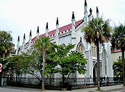
Extends into other parts of Charleston and into Dorchester National Register of Historic Places listings in Dorchester County, South Carolina This is a list of the National Register of Historic Places listings in Dorchester County, South Carolina.This is intended to be a complete list of the properties and districts on the National Register of Historic Places in Dorchester County, South Carolina, United States... counties |
||
| 5 | Battery Cheves | James Island 32°44′17"N 79°54′22"W |
James Island James Island (South Carolina) James Island is one of South Carolina's most urban Sea Islands. The island is separated from peninsular downtown Charleston by the Ashley River, from the mainland by Wappoo Creek and the Wappoo Cut, and from Johns Island by the Stono River... |
|||
| 6 | Battery LeRoy | Riverland Dr. 32°42′50"N 79°58′52"W |
James Island James Island (South Carolina) James Island is one of South Carolina's most urban Sea Islands. The island is separated from peninsular downtown Charleston by the Ashley River, from the mainland by Wappoo Creek and the Wappoo Cut, and from Johns Island by the Stono River... |
|||
| 7 | Battery No. 1 | Riverland Dr. 32°42′52"N 79°58′42"W |
James Island James Island (South Carolina) James Island is one of South Carolina's most urban Sea Islands. The island is separated from peninsular downtown Charleston by the Ashley River, from the mainland by Wappoo Creek and the Wappoo Cut, and from Johns Island by the Stono River... |
|||
| 8 | Battery No. 5 | Stonefield Subdivision 32°42′30"N 79°57′18"W |
James Island James Island (South Carolina) James Island is one of South Carolina's most urban Sea Islands. The island is separated from peninsular downtown Charleston by the Ashley River, from the mainland by Wappoo Creek and the Wappoo Cut, and from Johns Island by the Stono River... |
|||
| 9 | Battery Tynes | Stono River Stono River The Stono River is a tidal channel in southeast South Carolina, located southwest of Charleston. The channel runs southwest to northeast between the mainland and Wadmalaw Island and Johns Island, from north Edisto River between Johns and James Island. The Intracoastal Waterway runs through... 32°43′28"N 79°59′23"W |
James Island James Island (South Carolina) James Island is one of South Carolina's most urban Sea Islands. The island is separated from peninsular downtown Charleston by the Ashley River, from the mainland by Wappoo Creek and the Wappoo Cut, and from Johns Island by the Stono River... |
|||
| 10 | Battery Wilkes | St. Andrew's Parish 32°47′38"N 80°3′56"W |
West Ashley West Ashley West Ashley is one of the six distinct areas of the city proper of Charleston, South Carolina, with an estimated 2010 population of 57,403. Its name is derived from the fact that the land is west of the Ashley River. A few skirmishes took place there in the American Revolution and in the Civil War... |
|||
| 11 | 69 Barre St. 32°46′53"N 79°56′50"W |
Peninsula | ||||
| 12 | Bethel Methodist Church Old Bethel United Methodist Church (Charleston, South Carolina) Old Bethel United Methodist Church is located at 222 Calhoun St., Charleston, South Carolina.The building was built at 55 Pitt St. at the corner with Calhoun St. to replace a church built in 1797-1798... |
.jpg) |
57 Pitt St. 32°47′2"N 79°56′29"W |
Peninsula | ||
| 13 | .jpg) |
18 Bull St. 32°47′0"N 79°56′22"W |
Peninsula | |||
| 14 | Blake Tenements Blake Tenements The Blake Tenements were built between 1760 and 1772 by Daniel Blake, a planter from Newington Plantation on the Ashley River. The double tenement is three and one-half stories of brick on a high brick basement. The brickwork is laid in Flemish bond on the facade with English bond on the sides... |
_courthouse_square,_charleston_(charleston_county,_south_carolina).jpg) |
2-4 Courthouse Sq. 32°46′36"N 79°55′55"W |
Peninsula | ||
| 15 | Branford-Horry House Branford-Horry House The Branford-Horry House was already standing when William Brandford died in 1767. It is located at 59 Meeting Street, Charleston, South Carolina, USA. The three story house of stuccoed brick has very fine Georgian interiors. The front piazza, built over the sidewalk, was added by Branford's... |
.jpg) |
59 Meeting St. 32°46′28"N 79°55′53"W |
Peninsula | ||
| 16 | .jpg) |
27 King St. 32°46′21"N 79°55′59"W |
Peninsula | |||
| 17 |  |
71 Church St. 32°46′28"N 79°55′46"W |
Peninsula | |||
| 18 | Castle Pinckney Castle Pinckney Castle Pinckney was a small masonry fortification constructed by the United States government by 1810 in the harbor of Charleston, South Carolina... |
 |
Shute's Folly Island 32°46′25"N 79°54′41"W |
Shute's Folly Island Castle Pinckney Castle Pinckney was a small masonry fortification constructed by the United States government by 1810 in the harbor of Charleston, South Carolina... |
||
| 19 | Central Baptist Church Central Baptist Church (Charleston, South Carolina) Central Baptist Church is a historic church at 26 Radcliffe Street in Charleston, South Carolina.It was built in 1891 and added to the National Register in 1977.... |
26 Radcliffe St. 32°47′18"N 79°56′28"W |
Peninsula | |||
| 20 | Charleston Historic District Charleston Historic District The Charleston Historic District, also known as Charleston Old and Historic District, is a historic district in Charleston, South Carolina. It was declared a National Historic Landmark in 1960.... |
.jpg) |
An area roughly bounded by Broad, Bay, S. Battery, and Ashley, and an area along Church bounded by Cumberland and Chalmers; also an area roughly bounded by Calhoun, Archdale, Cumberland, E. Battery, Broad, and Gadsden, and an area along Anson St.; also incorporating most of the area south of Bee, Morris, and Mary Sts. to the waterfront; also King and Calhoun Sts.; also 25 and 25½ Warren and 114 St. Phillip Sts.; also 280 E. Bay St. 32°46′47"N 79°56′5"W |
Peninsula | Semicolons separate the original boundaries and boundary increases of , , , , and . The increase of 1978 is denominated "Charleston Historic District", and the increases of 1985 and 1986 are denominated "Charleston Old and Historic District". | |
| 21 | Charleston's French Quarter District | Bounded by Lodge Alley and Cumberland, E. Bay, and State Sts. 32°46′45"N 79°55′41"W |
Peninsula | |||
| 22 | Cigar Factory | Block bounded by East Bay, Columbus, Blake, and Drake Sts. 32°47′52"N 79°56′5"W |
Peninsula | |||
| 23 | Circular Congregational Church and Parish House Circular Congregational Church and Parish House Circular Congregational Church and Parish House is a church in Charleston, South Carolina that was built in Richardsonian Romanesque style circa 1892 , and its Greek revival-style parish house built in about 1806. The parish house was designed by Robert Mills, along with the original church on the... |
.jpg) |
150 Meeting St. 32°46′44"N 79°55′52"W |
Peninsula | ||
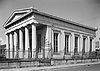
| 24 | Citizens and Southern National Bank of South Carolina Citizens & Southern National Bank Citizens and Southern National Bank began as a Georgia institution that expanded into South Carolina, Florida and into other states via mergers. C&S became part of NationsBank in 1991 when NationsBank bought newly merged C&S/Sovran... |
.jpg) |
50 Broad St. 32°46′36"N 79°55′48"W |
Peninsula | ||
| 25 | College of Charleston College of Charleston The College of Charleston is a public, sea-grant and space-grant university located in historic downtown Charleston, South Carolina, United States... |
 |
Glebe, George, St. Philip, and Green Sts. 32°47′4"N 79°56′15"W |
Peninsula | ||
| 26 | Coming Street Cemetery Coming Street Cemetery The Coming Street Cemetery is located at 189 Coming Street, in Charleston, South Carolina. This Jewish cemetery, one of the oldest in the United States was founded in 1762 and is the oldest Jewish burial ground in the South... |
189 Coming St. 32°47′23"N 79°56′34"W |
Peninsula | |||
| 27 | Dock Street Theatre Dock Street Theatre Dock Street Theatre is a theater in the historic French Quarter neighborhood of downtown Charleston, South Carolina. It was the first building in America designed for use as a theater. It is on the National Register of Historic Places... |
.jpg) |
135 Church St. 32°46′40"N 79°55′48"W |
Peninsula | ||
| 28 | Drayton Hall Drayton Hall Drayton Hall, in the South Carolina "Lowcountry" and about 15 miles northwest of Charleston, South Carolina and directly across the Ashley River from North Charleston, South Carolina, is one of the most handsome examples of Palladian architecture in North America.The house was built for John... |
|
12 miles west of Charleston on South Carolina Highway 61 South Carolina Highway 61 South Carolina Highway 61 is a long highway in the U.S. state of South Carolina. The highway is designated on an east–west direction, from U.S. Route 78 near Branchville to South Carolina Highway 30 in Charleston. The portion of Highway 61 from Church Creek Bridge and ten miles north is... 32°52′16"N 80°4′34"W |
West Ashley West Ashley West Ashley is one of the six distinct areas of the city proper of Charleston, South Carolina, with an estimated 2010 population of 57,403. Its name is derived from the fact that the land is west of the Ashley River. A few skirmishes took place there in the American Revolution and in the Civil War... |
||
| 29 | .jpg) |
900 King St. 32°48′6"N 79°56′55"W |
Peninsula | |||
| 30 | Exchange and Provost Exchange and Provost Exchange and Provost, also known as the Old Exchange & Provost Dungeon, Custom House and Half-Moon Battery, and The Exchange, was built in 1767.... |
.jpg) |
E. Bay and Broad Sts. 32°46′31"N 79°55′38"W |
Peninsula | ||
| 31 | Farmers' and Exchange Bank Farmers' and Exchange Bank Farmers' and Exchange Bank is a Moorish Revival-style bank building built in 1854 in Charleston, South Carolina. It was rehabilitated in 1970 and again in 1990.... |
.jpg) |
141 E. Bay St. 32°46′39"N 79°55′38"W |
Peninsula | ||
| 32 | Farmfield Plantation House | Farmfield Rd. 32°46′30"N 79°59′36"W |
West Ashley West Ashley West Ashley is one of the six distinct areas of the city proper of Charleston, South Carolina, with an estimated 2010 population of 57,403. Its name is derived from the fact that the land is west of the Ashley River. A few skirmishes took place there in the American Revolution and in the Civil War... |
|||
| 33 | Fenwick Hall Fenwick Hall The Fenwick Hall, which is also known as Fenwick Castle, is a house built about 1730 on Johns Island, South Carolina across the Stono River from James Island and Charleston. It is located between River Road and Penneys Creek... |
.jpg) |
South of Charleston on Johns Island, U.S. Route 17 U.S. Route 17 U.S. Route 17 or U.S. Highway 17 is a north–south United States highway. The highway spans the southeastern United States and is close to the Atlantic Coast for much of its length. The highway's southern terminus is at Punta Gorda, Florida, at an intersection with U.S. Route 41... 32°45′2"N 80°2′20"W |
Johns Island Johns Island, South Carolina Johns Island, also spelled John's Island, is the largest island in the U.S. State of South Carolina. It is one of the many Sea Islands along the coast of South Carolina.-Background:... |
||
| 34 | Fireproof Building Fireproof Building The Fireproof Building, also known as County Records Building, is located at 100 Meeting St., Charleston, South Carolina. It was designed by Robert Mills and constructed by John G. Spindle. It was completed by 1827. At that time, it was the most completely fireproof building in America and it is... |
 |
100 Meeting St. 32°46′36"N 79°55′55"W |
Peninsula | ||
| 35 | Florence Crittenton Home | 19 St. Margaret St. 32°48′12"N 79°57′18"W |
Peninsula | |||
| 36 | Fort Pringle | Riverland Dr. 32°42′50"N 79°59′7"W |
James Island James Island (South Carolina) James Island is one of South Carolina's most urban Sea Islands. The island is separated from peninsular downtown Charleston by the Ashley River, from the mainland by Wappoo Creek and the Wappoo Cut, and from Johns Island by the Stono River... |
|||
| 37 | Fort Sumter National Monument Fort Sumter Fort Sumter is a Third System masonry coastal fortification located in Charleston Harbor, South Carolina. The fort is best known as the site upon which the shots initiating the American Civil War were fired, at the Battle of Fort Sumter.- Construction :... |
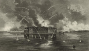 |
Charleston Harbor 32°45′8"N 79°52′29"W |
Harbor | ||
| 38 | Fort Trenholm | Johns Island Airport 32°42′29"N 79°59′49"W |
Johns Island Johns Island, South Carolina Johns Island, also spelled John's Island, is the largest island in the U.S. State of South Carolina. It is one of the many Sea Islands along the coast of South Carolina.-Background:... |
|||
| 39 | .jpg) |
64 S. Battery 32°46′14"N 79°55′59"W |
Peninsula | |||
| 40 | Greek Orthodox Church of the Holy Trinity Greek Orthodox Church of the Holy Trinity The Holy Trinity Greek Orthodox Church is located at 28 Race St., Charleston, South Carolina. The first Greek Orthodox church in South Carolina was built in 1911 at Fishburne and St. Phillip Sts. Construction of the present church was begun in 1950 and completed in 1953... |
30 Race St. 32°47′52"N 79°56′55"W |
Peninsula | |||
| 41 | Hampton Park Terrace Historic District Hampton Park Terrace Hampton Park Terrace is a neighborhood located in peninsular Charleston, South Carolina. The neighborhood is bounded on the west by the Citadel, on the north by Hampton Park, on the east by Rutledge Ave., and on the south by Congress St. In addition, the one block of Parkwood Ave. south of... |
Roughly bounded by Hagood and Rutledge Aves., and Moltrie and Congress Sts. 32°47′48"N 79°57′19"W |
Peninsula | |||
| 42 | .jpg) |
76 Church St. 32°46′26"N 79°55′44"W |
Peninsula | |||
| 43 | Heyward-Washington House Heyward-Washington House Heyward-Washington House is a historic house museum in Charleston, South Carolina that is owned and operated by the Charleston Museum. Furnished for the late 18th century, the house includes a collection of Charleston-made furniture... |
.jpg) |
87 Church St. 32°46′33"N 79°55′46"W |
Peninsula | ||
| 44 | Hibernian Hall |  |
105 Meeting St. 32°46′38"N 79°55′54"W |
Peninsula | ||
| 45 | Huguenot Church Huguenot Church The Huguenot Church, built in 1844 in Charleston, South Carolina, was the first Gothic Revival church in South Carolina and was designed by architect Edward Brickell White... |
 |
136 Church St. 32°46′50"N 79°55′45"W |
Peninsula | ||
| 46 | Kahal Kadosh Beth Elohim Synagogue Congregation Kahal Kadosh Beth Elohim Congregation Kahal Kadosh Beth Elohim is a historic synagogue located at 90 Hasell Street in Charleston, South Carolina... |
 |
90 Hasell St. 32°46′56"N 79°55′58"W |
Peninsula | ||
| 47 | Lowndes Grove Lowndes Grove The Lowndes Grove, also known as The Grove or Grove Farm, is a house built in about 1786 on the Ashley River in Charleston. It is located on a triangular plot of land bordered by St. Margaret Street, 5th Avenue, and 6th Avenue... |
,_saint_margaret_street__sixth_avenue,_charleston_(charleston_county,_south_carolina).jpg) |
260 St. Margaret St. 32°48′6"N 79°57′58"W |
Peninsula | ||
| 48 | Jonathan Lucas House | .jpg) |
286 Calhoun St. 32°46′57"N 79°56′54"W |
Peninsula | ||
| 49 | Magnolia Cemetery Magnolia Cemetery (Charleston, South Carolina) Magnolia Cemetery is a historic cemetery in Charleston, South Carolina.It was listed on the National Register of Historic Places as a Historic District in 1978.-Notable interments:*William Aiken, Jr. , US Congressman, South Carolina Governor... |
.jpg) |
North of Charleston off U.S. Route 52 U.S. Route 52 U.S. Route 52 is a United States highway that runs across the northern, eastern and southeastern regions of the United States. Contrary to most other even-numbered U.S... 32°49′6"N 79°56′32"W |
Peninsula | ||
| 50 | .jpg) |
350 Meeting St. 32°47′19"N 79°56′8"W |
Peninsula | |||
| 51 | Market Hall and Sheds Market Hall and Sheds Market Hall and the sheds of the City Market, or Centre Market, comprise a historic market complex in downtown Charleston, South Carolina, USA... |
188 Meeting St. 32°46′49"N 79°55′53"W |
Peninsula | Also known as the Old City Market; market stalls are located on the first story of Market Hall, and continue in a series of sheds stretching behind Market Hall all the way to E. Bay St. | ||
| 52 | McCrady's Tavern and Long Room McCrady's Tavern and Long Room McCrady's Tavern and Long Room is a historic tavern complex located in downtown Charleston, South Carolina, USA. Constructed in several phases in the second half of the 18th century, the tavern was a hub of social life in Charleston in the years following the American Revolution... |
153 E. Bay St. 32°46′41"N 79°55′38"W |
Peninsula | |||
| 53 | McLeod Plantation McLeod Plantation McLeod Plantation is located at 325 Country Club Drive. on James Island, South Carolina, near the intersection of Folly and Maybank Roads. Situated at Wappoo Creek which flows into the Ashley River, historic events have been recorded throughout the period from 1678 when it first appeared on maps... |
.jpg) |
325 Country Club Dr. 32°45′46"N 79°58′21"W |
James Island James Island (South Carolina) James Island is one of South Carolina's most urban Sea Islands. The island is separated from peninsular downtown Charleston by the Ashley River, from the mainland by Wappoo Creek and the Wappoo Cut, and from Johns Island by the Stono River... |
||
| 54 | .jpg) |
51 Broad St. 32°46′34"N 79°55′48"W |
Peninsula | A studio of the self-taught sculptor Clark Mills Clark Mills (sculptor) Clark Mills was an American sculptor, best known for three versions of an equestrian statue of Andrew Jackson, located in Washington, D.C., Nashville, Tennessee, and New Orleans, Louisiana.-Life:... on Broad Street. |
||
| 55 | Morris Island Lighthouse Morris Island Light Morris Island Light is a lighthouse on Morris Island in South Carolina. The light stands on the southern side of the entrance to Charleston Harbor, north of the City of Folly Beach.... |
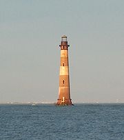 |
6 miles southeast of Charleston 32°41′43"N 79°53′2"W |
Morris Island Morris Island Morris Island is an 840 acre uninhabited island in Charleston Harbor in South Carolina, accessible only by boat. The island lies in the outer reaches of the harbor and was thus a strategic location in the American Civil War.-History:... |
||
| 56 | 3 Chisolm St. 32°46′26"N 79°56′33"W |
Peninsula | ||||
| 57 | .jpg) |
172 Rutledge Ave. 32°47′12"N 79°56′44"W |
Peninsula | |||
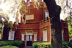
| 58 | Old Bethel United Methodist Church Old Bethel United Methodist Church (Charleston, South Carolina) Old Bethel United Methodist Church is located at 222 Calhoun St., Charleston, South Carolina.The building was built at 55 Pitt St. at the corner with Calhoun St. to replace a church built in 1797-1798... |
|
222 Calhoun St. 32°47′3"N 79°56′33"W |
Peninsula | ||
| 59 | Old Marine Hospital Old Marine Hospital Old Marine Hospital was designed by Robert Mills. Construction started in 1831 and was completed in 1833. It is a Gothic revival building at 20 Franklin St. in Charleston, South Carolina. It was built for sick sailors and other transient persons.... |
.jpg) |
20 Franklin St. 32°46′40"N 79°56′14"W |
Peninsula | ||
| 60 | Old Slave Mart Charleston Old Slave Mart The Old Slave Mart is a building located at 6 Chalmers Street in Charleston, South Carolina, USA, that once housed an antebellum slave auction gallery. Constructed in 1859, the building is believed to be the last extant slave auction gallery in South Carolina... |
6 Chalmers St. 32°46′38"N 79°55′48"W |
Peninsula | |||
| 61 | Porter Military Academy Charleston Arsenal The Charleston Arsenal was a United States Army arsenal facility in Charleston, South Carolina seized by state militia at the outbreak of the American Civil War.... |
 |
175-181 Ashley Ave. 32°47′12"N 79°56′52"W |
Peninsula | ||
| 62 | Powder Magazine | 79 Cumberland St. 32°46′45"N 79°55′51"W |
Peninsula | |||
| 63 | Presqui'ile Presqui'ile Presqu'ile, or Presqui'ile, , the French term for "peninsula", was an appropriate name for the house built at 2 Amherst St., Charleston, South Carolina between 1802 and 1808 because, at the time, the house stood on a finger of high ground that projected into the marshes of the Cooper River... |
.jpg) |
2 Amherst St. 32°47′43"N 79°56′0"W |
Peninsula | ||
| 64 | 6 Thomas St. 32°47′10"N 79°56′33"W |
Peninsula | ||||
| 65 | 12 Bee St. 32°47′14"N 79°56′50"W |
Peninsula | ||||
| 66 | .jpg) |
9 E. Battery St. 32°46′15"N 79°55′43"W |
Peninsula | |||
| 67 | .jpg) |
57-59 Church St. 32°46′24"N 79°55′46"W |
Peninsula | |||
| 68 | .jpg) |
51 Meeting St. 32°46′26"N 79°55′53"W |
Peninsula | |||
| 69 | .jpg) |
117 Broad St. 32°46′34"N 79°56′2"W |
Peninsula | |||
| 70 | .jpg) |
116 Broad St. 32°46′34"N 79°56′1"W |
Peninsula | |||
| 71 | .jpg) |
5 miles northwest of Charleston on South Carolina Highway 61 South Carolina Highway 61 South Carolina Highway 61 is a long highway in the U.S. state of South Carolina. The highway is designated on an east–west direction, from U.S. Route 78 near Branchville to South Carolina Highway 30 in Charleston. The portion of Highway 61 from Church Creek Bridge and ten miles north is... 32°50′19"N 80°2′57"W |
West Ashley West Ashley West Ashley is one of the six distinct areas of the city proper of Charleston, South Carolina, with an estimated 2010 population of 57,403. Its name is derived from the fact that the land is west of the Ashley River. A few skirmishes took place there in the American Revolution and in the Civil War... |
|||
| 72 | .jpg) |
93 Hasell St. 32°46′54"N 79°55′58"W |
Peninsula | |||
| 73 | .jpg) |
80 Meeting St. 32°46′34"N 79°55′51"W |
Peninsula | |||
| 74 | .jpg) |
146 Church St. 32°46′45"N 79°55′45"W |
Peninsula | |||
| 75 | Secessionville Historic District | North of Folly Beach 32°42′18"N 79°56′35"W |
James Island James Island (South Carolina) James Island is one of South Carolina's most urban Sea Islands. The island is separated from peninsular downtown Charleston by the Ashley River, from the mainland by Wappoo Creek and the Wappoo Cut, and from Johns Island by the Stono River... |
Extends into Folly Beach, elsewhere in Charleston County | ||
| 76 | Simmons-Edwards House Simmons-Edwards House The large, neoclassical Simmons-Edwards House was built for Francis Simmons, a Johns Island planter, about 1800. The house, located at 14 Legare St., Charleston, South Carolina, is famous for its large brick gates with decorative wrought iron. The gates, which were installed by George Edwards ... |
.jpg) |
12-14 Legare St. 32°46′21"N 79°56′3"W |
Peninsula | ||
| 77 | Site of Old Charles Towne Charles Towne Landing Charles Towne Landing is a park at the original site of the first permanent English settlement in South Carolina. Originally opened in 1970 to commemorate Charleston, South Carolina's tricentennial, this state park showcases animals indigenous to the state in 1670, with exhibits designed by... |
Albemarle Point 32°48′27"N 79°59′13"W |
West Ashley West Ashley West Ashley is one of the six distinct areas of the city proper of Charleston, South Carolina, with an estimated 2010 population of 57,403. Its name is derived from the fact that the land is west of the Ashley River. A few skirmishes took place there in the American Revolution and in the Civil War... |
Now part of a state historic site | ||
| 78 | South Carolina National Bank of Charleston | .jpg) |
16 Broad St. 32°46′37"N 79°55′39"W |
Peninsula | ||
| 79 | South Carolina State Arsenal | .jpg) |
2 Tobacco St. (Marion Sq.) 32°47′14"N 79°56′11"W |
Peninsula | ||
| 80 | 65 Cannon St. 32°47′20"N 79°56′42"W |
Peninsula | ||||
| 81 | Stiles-Hinson House | 940 Paul Revere Dr. 32°45′6"N 79°55′45"W |
James Island James Island (South Carolina) James Island is one of South Carolina's most urban Sea Islands. The island is separated from peninsular downtown Charleston by the Ashley River, from the mainland by Wappoo Creek and the Wappoo Cut, and from Johns Island by the Stono River... |
|||
| 82 |  |
104-106 Tradd St. 32°46′27"N 79°56′1"W |
Peninsula | |||
| 83 | Sword Gate Houses | ,_charleston_(charleston_county,_south_carolina).jpg) |
32 Legare St. and 111 Tradd St. 32°46′25"N 79°56′3"W |
Peninsula | ||
| 84 | 729 E. Bay St. 32°47′55"N 79°56′6"W |
Peninsula | ||||
| 85 | U.S. Customhouse U.S. Custom House (Charleston, South Carolina) The U.S. Custom House or U.S. Customhouse is the custom house in Charleston, South Carolina. Construction began in 1853, but was interrupted in 1859 due to costs and the possibility of South Carolina's secession from the Union. After the Civil War, construction was restarted in 1870 and completed... |
.jpg) |
200 E. Bay St. 32°46′50"N 79°55′37"W |
Peninsula | ||
| 86 | U.S. Post Office and Courthouse | .jpg) |
83 Broad St. 32°46′33"N 79°55′54"W |
Peninsula | ||
| 87 | Unitarian Church | .jpg) |
6 Archdale St. 32°46′20"N 79°56′2"W |
Peninsula | ||
| 88 | Unnamed Battery | St. Andrew 32°48′7"N 80°3′14"W |
West Ashley West Ashley West Ashley is one of the six distinct areas of the city proper of Charleston, South Carolina, with an estimated 2010 population of 57,403. Its name is derived from the fact that the land is west of the Ashley River. A few skirmishes took place there in the American Revolution and in the Civil War... |
|||
| 89 | 56 Bull St. 32°46′56"N 79°56′28"W |
Peninsula | ||||
| 90 | West Point Rice Mill West Point Rice Mill West Point Rice Mill is a former rice mill building in Charleston, South Carolina. It is at the City Marina at 17 Lockwood Drive. West Point Mill was one of three large rice mills in Charleston in the 19th century. This building was constructed in 1861 to replace a rice mill that had burned the... |
.jpg) |
Junction of Lockwood Dr. and Calhoun St. 32°46′44"N 79°57′4"W |
Peninsula |
Former listing
| Landmark name | Image | Dates | Location | Neighborhood | Summary | |
|---|---|---|---|---|---|---|
| 1 | Shaw Community Center | (delisted) | 22 Mary St. | Peninsula | Demolished to make way for new Boys & Girls Club building |
See also
- List of National Historic Landmarks in South Carolina
- National Register of Historic Places listings in South Carolina