

National Register of Historic Places in Yosemite National Park
Encyclopedia
This is a list of the National Register of Historic Places listings in Yosemite National Park.
This is intended to be a complete list of the properties and districts on the National Register of Historic Places
in Yosemite National Park
, California
, United States
. The locations of National Register properties and districts for which the latitude and longitude coordinates are included below, may be seen in a Google map.
There are 30 properties and districts listed on the National Register in the park and five National Historic Landmark
s. Four more properties associated with the park are located just outside the park boundaries.
This is intended to be a complete list of the properties and districts on the National Register of Historic Places
National Register of Historic Places
The National Register of Historic Places is the United States government's official list of districts, sites, buildings, structures, and objects deemed worthy of preservation...
in Yosemite National Park
Yosemite National Park
Yosemite National Park is a United States National Park spanning eastern portions of Tuolumne, Mariposa and Madera counties in east central California, United States. The park covers an area of and reaches across the western slopes of the Sierra Nevada mountain chain...
, California
California
California is a state located on the West Coast of the United States. It is by far the most populous U.S. state, and the third-largest by land area...
, United States
United States
The United States of America is a federal constitutional republic comprising fifty states and a federal district...
. The locations of National Register properties and districts for which the latitude and longitude coordinates are included below, may be seen in a Google map.
There are 30 properties and districts listed on the National Register in the park and five National Historic Landmark
National Historic Landmark
A National Historic Landmark is a building, site, structure, object, or district, that is officially recognized by the United States government for its historical significance...
s. Four more properties associated with the park are located just outside the park boundaries.
Current listings
| Landmark name | Image | Date listed | Location | City or Town | Summary | |
|---|---|---|---|---|---|---|
| 1 | Acting Superintendent's Headquarters Acting Superintendent's Headquarters The Acting Superintendent's Headquarters in Yosemite National Park was built by the U.S. Army at Camp A.E. Wood in the Wawona district of the park in 1904 to house the commander of the military administration that operated the park in the years prior to the establishment of the National Park... |
Yosemite National Park 37°32′20"N 119°39′17"W |
Wawona | |||
| 2 | Ahwahnee Hotel Ahwahnee Hotel The Ahwahnee Hotel is a destination hotel in Yosemite National Park, California, on the floor of Yosemite Valley, constructed from stone, concrete, wood and glass, which opened in 1927... |
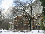 |
Yosemite Valley 37°44′45"N 119°34′22"W |
Yosemite National Park | ||
| 3 | Camp 4 Camp 4 (Yosemite) Camp 4 is a campground in Yosemite National Park. It became notable after World War II as the hangout for rock climbers with many spending months there . It is located near Yosemite Falls, on the north side of the valley. There is a single parking lot at the campground, and no driveways connecting... |
 |
Northside Dr., Yosemite National Park 37°44′30"N 119°36′9"W |
Yosemite | ||
| 4 | Camp Curry Historic District |  |
Yosemite Valley 37°44′36"N 119°34′16"W |
Yosemite National Park | ||
| 5 | Crane Flat Fire Lookout Crane Flat Fire Lookout The Crane Flat Fire Lookout in Yosemite National Park was built in 1931. An example of the National Park Service Rustic style, the lookout is a two-story structure with a lower storage or garage level and an upper observation level, with an overhanging roof... |
N of Big Oak Flat Rd., near Crane Cr., Yosemite National Park 37°45′34"N 119°49′10"W |
Aspen Valley | |||
| 6 | Glacier Point Trailside Museum Glacier Point Trailside Museum The Glacier Point Trailside Museum was one of the first projects in Yosemite National Park by Herbert Maier in what would become the National Park Service Rustic style. Located at Glacier Point, it was funded by Laura Spelman Rockefeller's estate as a project for the Yosemite Museum... |
E of El Portal in Yosemite National Park 37°43′50"N 119°34′23"W |
El Portal | |||
| 7 | Great Sierra Mine Historic Site Great Sierra Mine Historic Site The Great Sierra Mine Historic Site preserves the site of the largest mining operation in what would become Yosemite National Park. The mine was located on Tioga Hill on the crest and eastern slope of the Sierra Nevada, one of several claims intended to work the Sheepherder silver lode... |
W of Lee Vining in Yosemite National Park 37°55′39"N 119°16′5"W |
Lee Vining | |||
| 8 | Great Sierra Wagon Road Great Sierra Wagon Road The Great Sierra Wagon Road was a route through the Sierra Nevada in California, built to bring supplies to the Great Sierra Mine on Tioga Hill in the high country of what was to become Yosemite National Park. The road was built in 1882 by the Great Sierra Silver Mining Company, extending over , in... |
N of Yosemite Village 37°50′32"N 119°43′20"W |
Yosemite Valley | |||
| 9 | Hodgdon Homestead Cabin Hodgdon Homestead Cabin The Hodgdon Homestead Cabin was built by Jeremiah Hodgdon in 1879 in the Aspen Valley area of what became Yosemite National Park. The two story log cabin, measuring by , was located in an inholding in the park, owned by Hodgdon's descendants. In the 1950s the family proposed to demolish the... |
Yosemite National Park 37°32′20"N 119°39′19"W |
Wawona | |||
| 10 | Chris Jorgenson Studio Chris Jorgenson Studio The Chris Jorgenson Studio is a one room log building, built in 1904 as an artist's studio for Chris Jorgenson in the Yosemite Valley. Jorgenson, an instructor and assistant director of the California School of Fine Arts, arrived in Yosemite in the 1890s. Jorgenson studied and depicted local native... |
Pioneer Yosemite Historic Center 37°32′20"N 119°39′19"W |
Yosemite National Park | |||
| 11 | LeConte Memorial Lodge LeConte Memorial Lodge The LeConte Memorial Lodge is a structure in Yosemite National Park in California, United States. LeConte is spelled variously as Le Conte or as Leconte. The lodge was declared a National Historic Landmark in 1987.-History:... |
 |
Yosemite Valley, Yosemite National Park 37°44′24"N 119°34′42"W |
Curry Village | ||
| 12 | Mariposa Grove Museum |  |
SE of Wawona in Yosemite National Park 37°30′50"N 119°35′54"W |
Wawona | ||
| 13 | McCauley Cabin | W of Lee Vining at Tuolumne Meadows 37°52′40"N 119°22′1"W |
Lee Vining | |||
| 14 | McCauley and Meyer Barns McCauley and Meyer Barns The McCauley and Meyer Barns in Yosemite National Park are the last barns in the park that retain their original characteristics as structures built by homesteaders. The McCauley barn and the two Meyer barns represent different construction techniques and styles of design.The McCauley Barn was... |
North of El Portal in Yosemite National Park 37°42′0"N 119°45′18"W |
El Portal | |||
| 15 | McGurk Cabin McGurk Cabin The McGurk Cabin in Yosemite National Park was the seasonal home of Yosemite cattleman Jack McGurk from 1895 to 1897. Located on the edge of McGurk's Meadow, just to the north of the Glacier Point Road, the cabin was used by a series of owners beginning with Hugh Davanay, from whom McGurk bought... |
South of Yosemite Village 37°40′40"N 119°37′27"W |
Yosemite Village | |||
| 16 | Merced Grove Ranger Station Merced Grove Ranger Station The Merced Grove Ranger Station in Yosemite National Park was designed by the National Park Service and completer in 1935. An example of the National Park Service Rustic style, it features log construction. The station is near the Merced Grove of giant sequoias, in the Crane Flat region of the... |
North of El Portal in Yosemite National Park 37°44′56"N 119°50′21"W |
El Portal | |||
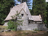
| 17 | Parsons Memorial Lodge Parsons Memorial Lodge The Parsons Memorial Lodge is a small building built in 1915 by the Sierra Club at the northern end of Tuolumne Meadows of Yosemite National Park. It was one of the earliest structures built of stone in a National Park.-Memorial:... |
Tuolumne Meadows 37°52′42"N 119°22′0"W |
Yosemite National Park | |||
| 18 | Rangers' Club Rangers' Club The Rangers' Club is a building in Yosemite Valley in Yosemite National Park that was donated by the independently wealthy first director of the National Park Service, Stephen Tyng Mather. He intended it to be used by the newly hired park rangers who were taking over from the departing army... |
Yosemite Valley Yosemite Valley Yosemite Valley is a glacial valley in Yosemite National Park in the western Sierra Nevada mountains of California, carved out by the Merced River. The valley is about long and up to a mile deep, surrounded by high granite summits such as Half Dome and El Capitan, and densely forested with pines... 37°44′50"N 119°35′12"W |
Yosemite National Park | |||
| 19 | Soda Springs Cabin Soda Springs Cabin The Soda Springs Cabin was built about 1889 in what would soon become Yosemite National Park, by John Baptist Lembert, the first European settler on the Tuolumne Meadows area of Yosemite. Lembert had filed a claim to in Tuolumne Meadows in 1885 after spending three summers in the area with a flock... |
SW of Lee Vining 37°52′44"N 119°21′56"W |
Lee Vining | |||
| 20 | Tioga Pass Entrance Station Tioga Pass Entrance Station The Tioga Pass Entrance Station is the primary entrance for travelers entering Yosemite National Park from the east on the Tioga Pass Road. Open only during the summer months, the entrance station consists of two historical buildings, a ranger station and a comfort station, built in 1931 and 1934... |
SW of Lee Vining in Yosemite National Park 37°54′39"N 119°15′27"W |
Lee Vining | |||
| 21 | Tuolumne Meadows Tuolumne Meadows Tuolumne Meadows is a gentle, dome-studded sub-alpine meadowy section of the Tuolumne River, in the eastern section of Yosemite National Park. Its approximate location is . Its approximate elevation is 8619 feet .-Natural History:... |
 |
SW of Lee Vining in Yosemite National Park 37°52′17"N 119°22′20"W |
Lee Vining | ||
| 22 | Tuolumne Meadows Ranger Stations and Comfort Stations Tuolumne Meadows Ranger Stations and Comfort Stations The Tuolumne Meadows Ranger Station and Comfort Stations are examples of National Park Service Rustic design in Yosemite National Park. The ranger station was built in 1924 using peeled log construction. The ranger station doubled as the park entrance station for the Tioga Road... |
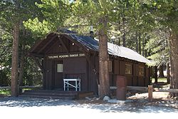 |
SW of Lee Vining in Yosemite National Park 37°52′24"N 119°21′16"W |
Lee Vining | ||
| 23 | Wawona Covered Bridge Wawona Covered Bridge The Wawona Covered Bridge is a covered bridge spanning the South Fork of the Merced River near Wawona, California in Yosemite National Park. The bridge was built by Galen Clark, the steward of what was then called the Yosemite Grant, in 1868, without its cladding. The bridge was a major component... |
Pioneer Yosemite History Center 37°32′19"N 119°39′17"W |
Wawona | |||
| 24 | Wawona Hotel and Pavilion Wawona Hotel The Wawona Hotel is a historic hotel located within Yosemite National Park. It was declared a National Historic Landmark in 1987.Wawona Hotel is one of the oldest mountain resort hotels in California and a classic of Victorian era resorts. The Victorian style hotel was built in 1876 to serve... |
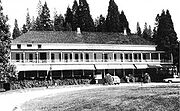 |
On CA 41 in Yosemite National Park 37°32′11"N 119°39′13"W |
Wawona | ||
| 25 | Yosemite Transportation Company Office Yosemite Transportation Company Office The Yosemite Transportation Company Office, also known as the Wells Fargo Office, was built in the Yosemite Valley in 1910 to house facilities of motor stage and horse stage services between the nearest rail terminal at El Portal and Yosemite National Park The rustic log structure also provided... |
N of Wawona in Yosemite National Park 37°32′20"N 119°39′17"W |
Wawona | |||
| 26 | Yosemite Valley Yosemite Valley Yosemite Valley is a glacial valley in Yosemite National Park in the western Sierra Nevada mountains of California, carved out by the Merced River. The valley is about long and up to a mile deep, surrounded by high granite summits such as Half Dome and El Capitan, and densely forested with pines... |
Yosemite National Park 37°43′43"N 119°36′7"W |
Yosemite | |||
| 27 | Yosemite Valley Archeological District | Address Restricted | Yosemite Village | |||
| 28 | Yosemite Valley Bridges Yosemite Valley Bridges The Yosemite Valley Bridges are eight bridges in the Yosemite Valley of Yosemite National Park, most of them spanning the Merced River. Five of them were built in 1928, with the remainder built between 1921 and 1933. The bridges feature a concrete structure faced with local stone, in an elliptical... |
8 Bridges over Merced River, Yosemite National Park 37°43′58"N 119°36′0"W |
Yosemite Village | |||
| 29 | Yosemite Valley Chapel Yosemite Valley Chapel The Yosemite Valley Chapel was built in the Yosemite Valley of California in 1879. Originally located in what was then called the "Lower Village" at what is now the Four Mile Trail trailhead, the chapel was moved to its present site in 1901 as the old village dwindled... |
Off CA 140 37°44′27"N 119°35′26"W |
Yosemite National Park | |||
| 30 | Yosemite Village Historic District Yosemite Village Historic District The Yosemite Village Historic District encompasses the primary built-up section of the Yosemite Valley as it was developed by the National Park Service for Yosemite National Park. The district includes visitor services areas, park personnel residences and administrative facilities. It is located to... |
East of El Portal in Yosemite National Park 37°44′55"N 119°35′18"W |
El Portal |
Associated properties
The following properties are on property owned by the National Park Service and administered by Yosemite National Park, but are not within the park proper:| Landmark name | Image | Date listed | Location | City or Town | Summary | |
|---|---|---|---|---|---|---|
| 1 | Bagby Stationhouse, Water Tanks and Turntable Bagby Stationhouse, Water Tanks and Turntable The Bagby Stationhouse, Water Tanks and Turntable are associated with the Yosemite Valley Railroad , which ran from Merced, California to El Portal at the entrance to Yosemite National Park. The railroad operated from 1907 to 1945... |
CA 140 37°40′27"N 119°46′47"W |
El Portal | |||
| 2 | Hetch Hetchy Railroad Engine No.6 | 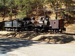 |
CA 140 37°40′30"N 119°46′46"W |
El Portal | Shay railroad engine used to build O'Shaughnessy Dam. On Park Service property just outside the park proper. | |
| 3 | Track Bus No. 19 | CA 140 37°40′30"N 119°46′46"W |
El Portal | |||
| 4 | Yosemite Valley Railroad Caboose No. 15 | CA 140 37°40′30"N 119°46′46"W |
El Portal |
See also
- National Register of Historic Places listings in Mariposa County, California
- National Register of Historic Places listings in Tuolumne County, California
- National Register of Historic Places listings in California