

N2 (South Africa)
Encyclopedia
The N2 is a National Route in South Africa
; it is the main highway along the Indian Ocean
coast of the country. The N2 starts in Cape Town
in the Western Cape
and runs through the cities of Port Elizabeth and East London in the Eastern Cape
and Durban
in KwaZulu-Natal
to end at Ermelo
in Mpumalanga
.
, Somerset West, Caledon
, Swellendam
, Mossel Bay
, George
, Knysna
, Humansdorp
, Port Elizabeth, Grahamstown
, King William's Town
, Bhisho, East London, Mthatha
, Kokstad
, Port Shepstone, Durban
, KwaDukuza, Empangeni, Piet Retief
, and Ermelo
.
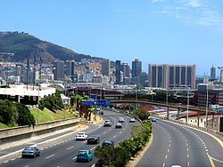 The N2 begins in central Cape Town
at the northern end of Buitengracht Street outside the entrance to the Victoria & Alfred Waterfront
. The first section of the N2 is shared with
the beginning of the N1
; it is a four-lane elevated freeway that runs along a strip of land between the city centre and the Port of Cape Town
. On the eastern edge of the city centre the two roads split, and the N2 turns south as Eastern Boulevard, crossing above the yards and approach tracks of Cape Town railway station
.
The N2 descends to ground level in Woodstock before approaching the major interchange known as "Hospital Bend
" because of its proximity to Groote Schuur Hospital
. In this interchange, the N2 and the M3
merge to form a massive 10-lane freeway before diverging again. Because Hospital Bend is built on a steeply sloping curve, and lane-changing is often necessary to travel through the intersection, it was notorious for congestion and accidents, until it was upgraded between 2008 and 2010. http://www.civildesigner.com/showcase/bks/carlos.asphttp://www.capetown.gov.za/en/roads/Pages/N2SettlersFreeway.aspx
After Hospital Bend the N2 turns east to travel across the Cape Flats
as a 6-lane freeway to Somerset West; this section is known as Settler's Way. Along this route it crosses the M5
, M7
and R300
freeways; it also travels just past the end of the main runway at Cape Town International Airport
In Somerset West it is reduced to an undivided highway, passing through several intersections with traffic lights, which cause frequent congestion.
East of Somerset West the N2 climbs Sir Lowry's Pass
to enter the Overberg
region. It passes near the town of Grabouw
on the Hottentots-Holland
plateau before descending the Houwhoek Pass
to Botrivier. After Botrivier it passes across the agricultural plains through the towns of Caledon
, Riviersonderend
, Swellendam
and Riversdale
to re-approach the coast at Mossel Bay
, which marks the beginning of the Garden Route
.
 Just west of Mossel Bay the N2 again becomes a divided freeway, and remains one as far as the intersection with the N9
just outside of George
. From there it travels across Kaaiman's Pass (see below) to Wilderness
and on to Knysna
and Plettenberg Bay
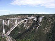
. After Plettenberg Bay a section of the road is tolled
as the Tsitsikamma
Toll Route, primarily because of the Bloukrans Bridge
; an alternative route runs through Nature's Valley
. The Bloukrans Bridge marks the border with the Eastern Cape
.
and Jeffrey's Bay before becoming a four-lane divided freeway through the city of Port Elizabeth, ending at Coega
. The N2 continues in a north-easterly direction from Port Elizabeth, moving away from the coast towards Grahamstown
; en route the N10
splits from the N2, going northwards towards Middelburg
. After Grahamstown the N2 passes through the former Ciskei
; at King William's Town
it turns back towards the coast, meeting it at East London. The N2 passes around East London on a bypass; it meets the N6 which runs northwards from East London towards Bloemfontein
.
After East London the N2 turns again towards the interior, to avoid the difficult terrain of the Wild Coast
. It passes through the former Transkei
and its former capital Mthatha
. Near Kokstad, KwaZulu-Natal
the N2 crosses into the province of KwaZulu-Natal
.
. At the Westville
four-level bypass the N2 meets the N3
from Johannesburg
.
After Durban the N2 continues as a freeway along the Natal North Coast past Umhlanga Rocks, Ballito and Tongaat, with the freeway ending at KwaDukuza. It passes the port of Richard's Bay and turns north, moving away from the coast into the heart of Zululand
. It passes close to the Greater St Lucia Wetland Park and the Hluhluwe-Umfolozi Game Reserve
. It approaches the border with Swaziland
near to the border post of Golela
, and turns westwards, running just south of the border through the town of Pongola
before entering Mpumalanga
province.
, from which it travels north-west to end in the town of Ermelo
. Ermelo is connected by the N17
to Johannesburg
and Mbabane
, and by the N11
to Mokopane
and Ladysmith
.
and Wilderness
. This caused the road to be temporarily closed from 26 August 2006. As a result of the slide a section of roadway sagged and large cracks appeared on the road surface. After an inspection by a team of engineers a single lane was reopened on 29 August for vehicles with a gross mass of under 5000 kg.
An alternative route following the Saasveld
road was put into use, but this road only allows for a single lane of traffic and light vehicles. Heavy vehicles have to take an alternative route via the R62 and Langkloof
pass effectively lengthening the distance from George to Wilderness from 11 km to over 600 km (news24.com story). The road has since reopened but major repairs are being done.
Traffic on the N2 has also been disrupted on numerous occasions because of protests. On 10 September 2007, residents of Joe Slovo Informal Settlement blockaded the N2 Freeway in Cape Town near Langa
. Police responded with rubber bullets injuring over 30 residents. On 4 December 2008, a few thousand residents of eMachambini, between KwaDukuza and Richards Bay in KZN, blockaded the N2 Freeway in protest against the proposed AmaZulu World Themepark. Police opened fire and injured about 23 residents and arrest about 10.
South Africa
The Republic of South Africa is a country in southern Africa. Located at the southern tip of Africa, it is divided into nine provinces, with of coastline on the Atlantic and Indian oceans...
; it is the main highway along the Indian Ocean
Indian Ocean
The Indian Ocean is the third largest of the world's oceanic divisions, covering approximately 20% of the water on the Earth's surface. It is bounded on the north by the Indian Subcontinent and Arabian Peninsula ; on the west by eastern Africa; on the east by Indochina, the Sunda Islands, and...
coast of the country. The N2 starts in Cape Town
Cape Town
Cape Town is the second-most populous city in South Africa, and the provincial capital and primate city of the Western Cape. As the seat of the National Parliament, it is also the legislative capital of the country. It forms part of the City of Cape Town metropolitan municipality...
in the Western Cape
Western Cape
The Western Cape is a province in the south west of South Africa. The capital is Cape Town. Prior to 1994, the region that now forms the Western Cape was part of the much larger Cape Province...
and runs through the cities of Port Elizabeth and East London in the Eastern Cape
Eastern Cape
The Eastern Cape is a province of South Africa. Its capital is Bhisho, but its two largest cities are Port Elizabeth and East London. It was formed in 1994 out of the "independent" Xhosa homelands of Transkei and Ciskei, together with the eastern portion of the Cape Province...
and Durban
Durban
Durban is the largest city in the South African province of KwaZulu-Natal and the third largest city in South Africa. It forms part of the eThekwini metropolitan municipality. Durban is famous for being the busiest port in South Africa. It is also seen as one of the major centres of tourism...
in KwaZulu-Natal
KwaZulu-Natal
KwaZulu-Natal is a province of South Africa. Prior to 1994, the territory now known as KwaZulu-Natal was made up of the province of Natal and the homeland of KwaZulu....
to end at Ermelo
Ermelo, Mpumalanga
Ermelo is the educational, industrial and commercial centre of the 7,750 km² Gert Sibande District Municipality in Mpumalanga province, Republic of South Africa. Mixed farming and anthracite, coal and torbanite mining take place here...
in Mpumalanga
Mpumalanga
Mpumalanga , is a province of South Africa. The name means east or literally "the place where the sun rises" in Swazi, Xhosa, Ndebele and Zulu. Mpumalanga lies in eastern South Africa, north of KwaZulu-Natal and bordering Swaziland and Mozambique. It constitutes 6.5% of South Africa's land area...
.
Route
Major towns and cities along the route of the N2 include Cape TownCape Town
Cape Town is the second-most populous city in South Africa, and the provincial capital and primate city of the Western Cape. As the seat of the National Parliament, it is also the legislative capital of the country. It forms part of the City of Cape Town metropolitan municipality...
, Somerset West, Caledon
Caledon, Western Cape
Caledon is a town in the Overberg region in the Western Cape province of South Africa, located about east of Cape Town. it had a population of 10,650. It is located in, and the seat of, the Theewaterskloof Local Municipality....
, Swellendam
Swellendam
Swellendam is the third oldest town in the Republic of South Africa, a town with 28,072 inhabitants situated in the Western Cape province. The town has over 50 National monuments most of them buildings of Cape Dutch architecture....
, Mossel Bay
Mossel Bay
Mossel Bay is a harbour town of about 130,000 people on the Southern Cape of South Africa. It is an important tourism and farming region of the Western Cape Province...
, George
George, Western Cape
George is a city with 203,253 inhabitants in South Africa's Western Cape province. The city is a popular holiday and conference centre and the administrative and commercial hub of the Garden Route.- Location :...
, Knysna
Knysna
Knysna is a town with 76,431 inhabitants in the Western Cape Province of South Africa and is part of the Garden Route. It lies 34 degrees south of the equator, and is 72 kilometres east from the town of George on the N2 highway, and 25 kilometres west of Plettenberg Bay on the same road.-History:A...
, Humansdorp
Humansdorp
Humansdorp is a small town and surrounding district in the Eastern Cape of South Africa, with a population of around 35,000 . It is part of the Kouga Local Municipality of the Cacadu District. The town is the centre of the district's light industry and farming...
, Port Elizabeth, Grahamstown
Grahamstown
Grahamstown is a city in the Eastern Cape Province of the Republic of South Africa and is the seat of the Makana municipality. The population of greater Grahamstown, as of 2003, was 124,758. The population of the surrounding areas, including the actual city was 41,799 of which 77.4% were black,...
, King William's Town
King William's Town
King William's Town is a town in the Eastern Cape province of South Africa along the banks of the Buffalo River. The town is about 40 minutes' motorway drive WNW of the Indian Ocean port of East London...
, Bhisho, East London, Mthatha
Mthatha
Mthatha is the main town of the King Sabata Dalindyebo Local Municipality in Eastern Cape province of South Africa. The town has an airport, previously known by the name K. D. Matanzima Airport after former leader Kaiser Matanzima....
, Kokstad
Kokstad, KwaZulu-Natal
Kokstad is a town in the Sisonke District of KwaZulu-Natal Province, South Africa. Kokstad is named after the Griqua chief Adam Kok III who settled here in 1863. Stad is the Dutch and Afrikaans word for city....
, Port Shepstone, Durban
Durban
Durban is the largest city in the South African province of KwaZulu-Natal and the third largest city in South Africa. It forms part of the eThekwini metropolitan municipality. Durban is famous for being the busiest port in South Africa. It is also seen as one of the major centres of tourism...
, KwaDukuza, Empangeni, Piet Retief
Piet Retief, Mpumalanga
Piet Retief is a town situated in a timber growing region in Mpumalanga province, South Africa. Its is the seat of the Mkhondo Local Municipality. It is located not far from the Swaziland border...
, and Ermelo
Ermelo, Mpumalanga
Ermelo is the educational, industrial and commercial centre of the 7,750 km² Gert Sibande District Municipality in Mpumalanga province, Republic of South Africa. Mixed farming and anthracite, coal and torbanite mining take place here...
.
Western Cape
Cape Town
Cape Town is the second-most populous city in South Africa, and the provincial capital and primate city of the Western Cape. As the seat of the National Parliament, it is also the legislative capital of the country. It forms part of the City of Cape Town metropolitan municipality...
at the northern end of Buitengracht Street outside the entrance to the Victoria & Alfred Waterfront
Victoria & Alfred Waterfront
The Victoria & Alfred Waterfront in the historic heart of Cape Town's working harbour is South Africa's most-visited destination, having the highest rate of foreign tourists of any attraction in the country...
. The first section of the N2 is shared with
Concurrency (road)
A concurrency, overlap, or coincidence in a road network is an instance of one physical road bearing two or more different highway, motorway, or other route numbers...
the beginning of the N1
N1 (South Africa)
The N1 is a South African National Route, running from Cape Town to Beit Bridge on the border with Zimbabwe. It is also the main road link between Johannesburg and Cape Town, and forms the first section of the famed Cape to Cairo Road....
; it is a four-lane elevated freeway that runs along a strip of land between the city centre and the Port of Cape Town
Port of Cape Town
The Port of Cape Town is the port of the city of Cape Town, South Africa. It is situated in Table Bay.Because of its position along one of the world's busiest trade routes it is one of the busiest ports in South Africa, handling the largest amount of fresh fruit and second only to Durban as a...
. On the eastern edge of the city centre the two roads split, and the N2 turns south as Eastern Boulevard, crossing above the yards and approach tracks of Cape Town railway station
Cape Town Railway Station
Cape Town railway station is the main railway station of the city of Cape Town, South Africa. It is located along Adderley and Strand Streets in the city's central business district....
.
The N2 descends to ground level in Woodstock before approaching the major interchange known as "Hospital Bend
Hospital Bend
Hospital Bend is a major freeway junction, located to the east of the central business district of Cape Town, South Africa. It is the junction between the N2 national route and the M3 metropolitan expressway. Its unusual design led to notoriety as a traffic bottleneck and a frequent accident...
" because of its proximity to Groote Schuur Hospital
Groote Schuur Hospital
Groote Schuur Hospital is a large, government-funded, teaching hospital situated on the slopes of Devil's Peak in the city of Cape Town, South Africa...
. In this interchange, the N2 and the M3
M3 (Cape Town)
The M3 is an expressway in Cape Town, South Africa, connecting the upper part of the City Bowl to the Southern Suburbs and ending in Tokai. For most of its route it parallels - though further to the south and west - the M4 , which was the original road connecting central Cape Town with the...
merge to form a massive 10-lane freeway before diverging again. Because Hospital Bend is built on a steeply sloping curve, and lane-changing is often necessary to travel through the intersection, it was notorious for congestion and accidents, until it was upgraded between 2008 and 2010. http://www.civildesigner.com/showcase/bks/carlos.asphttp://www.capetown.gov.za/en/roads/Pages/N2SettlersFreeway.aspx
After Hospital Bend the N2 turns east to travel across the Cape Flats
Cape Flats
The Cape Flats is an expansive, low-lying, flat area situated to the southeast of the central business district of Cape Town. To many people in Cape Town, the area is known simply as 'The Flats'....
as a 6-lane freeway to Somerset West; this section is known as Settler's Way. Along this route it crosses the M5
M5 (Cape Town)
The M5 is an expressway in Cape Town, South Africa. It connects the northern suburbs to Muizenberg in the south, and crosses both the N1 and the N2...
, M7
M7 (Cape Town)
The M7, also named Vanguard Drive, is an limited-access road in Cape Town, South Africa. It is an extension of the N7 national road, which ends at an intersection with the N1. The M7 continues southwards from this intersection through the Cape Flats to end at the False Bay coast. Along its route it...
and R300
R300 (Western Cape)
The R300 or Kuils River Freeway is a Regional Route in Cape Town, South Africa that connects Mitchells Plain with the N2, Kuils River, and the N1 at Bellville...
freeways; it also travels just past the end of the main runway at Cape Town International Airport
Cape Town International Airport
Cape Town International Airport is the primary airport serving the city of Cape Town, and is the second busiest airport in South Africa and third busiest in Africa. Located approximately from the city centre, the airport was opened in 1954 to replace Cape Town's previous airport in the suburb of...
In Somerset West it is reduced to an undivided highway, passing through several intersections with traffic lights, which cause frequent congestion.
East of Somerset West the N2 climbs Sir Lowry's Pass
Sir Lowry's Pass
Sir Lowry's Pass is a mountain pass on the N2 national road in the Western Cape province of South Africa. It crosses the Hottentots-Holland mountain range between Somerset West and Grabouw on the main national road between Cape Town and the Garden Route...
to enter the Overberg
Overberg
Overberg is a district in South Africa to the east of Cape Town beyond the Hottentots-Holland mountains. It lies along the Cape Province's south coast between the Cape Peninsula and the region known as the Garden Route in the east...
region. It passes near the town of Grabouw
Grabouw
Grabouw is a mid-sized town located in the Western Cape province of South Africa some 65 km south-east of Cape Town along the N2 highway. It is located over Sir Lowry's Pass from Somerset West in the Elgin Valley, which is sandwiched between the Hottentots-Holland, Kogelberg and Groenland...
on the Hottentots-Holland
Hottentots-Holland
The Hottentots Holland mountain range is part of the Cape Fold Belt in the Western Cape, South Africa. The range forms a barrier between the Cape Town metropolitan area and the southern Overberg coast. The range is primarily composed of Table Mountain Sandstone and forms an impressive range to the...
plateau before descending the Houwhoek Pass
Houwhoek Pass
Houwhoek Pass is a pass on the N2 national road between Grabouw and Botrivier in the Western Cape province of South Africa. The pass is a dual carriageway and the summit is at 340m above sea level....
to Botrivier. After Botrivier it passes across the agricultural plains through the towns of Caledon
Caledon, Western Cape
Caledon is a town in the Overberg region in the Western Cape province of South Africa, located about east of Cape Town. it had a population of 10,650. It is located in, and the seat of, the Theewaterskloof Local Municipality....
, Riviersonderend
Riviersonderend
Riviersonderend is a small town in the Overberg region of the Western Cape, South Africa, about east of Cape Town. It is located on a loop of the Sonderend River, from which it takes its name...
, Swellendam
Swellendam
Swellendam is the third oldest town in the Republic of South Africa, a town with 28,072 inhabitants situated in the Western Cape province. The town has over 50 National monuments most of them buildings of Cape Dutch architecture....
and Riversdale
Riversdale, Western Cape
Riversdale is a town located on the N2 highway between Cape Town and George on the Agulhas Coastal Plain of the southern Western Cape province of South Africa. It is an agricultural service orientated town, being a hub for shopping and other services for surrounding farming communities, smaller...
to re-approach the coast at Mossel Bay
Mossel Bay
Mossel Bay is a harbour town of about 130,000 people on the Southern Cape of South Africa. It is an important tourism and farming region of the Western Cape Province...
, which marks the beginning of the Garden Route
Garden Route
The Garden Route is a popular stretch of the south-eastern coast of South Africa. It stretches from Heidelberg in the Western Cape to the Storms River which is crossed along the N2 coastal highway over the Paul Sauer Bridge in the extreme western reach of the neighbouring Eastern Cape...
.
N9 (South Africa)
The N9 is one of the National Roads of South Africa, connecting George in the Western Cape to the N1 at Colesberg in the Northern Cape.-Route:...
just outside of George
George, Western Cape
George is a city with 203,253 inhabitants in South Africa's Western Cape province. The city is a popular holiday and conference centre and the administrative and commercial hub of the Garden Route.- Location :...
. From there it travels across Kaaiman's Pass (see below) to Wilderness
Wilderness, Western Cape
Wilderness is a seaside town on the Garden Route of the southern Cape in South Africa.It is situated a short distance east from the city of George, on the N2 down the Kaaiman's River Pass. It is known for its long white sand beach and lagoons...
and on to Knysna
Knysna
Knysna is a town with 76,431 inhabitants in the Western Cape Province of South Africa and is part of the Garden Route. It lies 34 degrees south of the equator, and is 72 kilometres east from the town of George on the N2 highway, and 25 kilometres west of Plettenberg Bay on the same road.-History:A...
and Plettenberg Bay
Plettenberg Bay
Plettenberg Bay, nicknamed Plet or Plett, is the primary town of the Bitou Local Municipality in the Western Cape Province of South Africa. As of the census of 2001, there were 29149 population...
. After Plettenberg Bay a section of the road is tolled
Toll road
A toll road is a privately or publicly built road for which a driver pays a toll for use. Structures for which tolls are charged include toll bridges and toll tunnels. Non-toll roads are financed using other sources of revenue, most typically fuel tax or general tax funds...
as the Tsitsikamma
Tsitsikamma Mountains
The Tsitsikamma mountains are a mountain range located in the Garden Route region of the southern South African coast in the Western Cape and Eastern Cape provinces. Stretching just over 80 km from the Keurbooms River in the west just north of Plettenberg Bay, to Kareedouw Pass in the east near the...
Toll Route, primarily because of the Bloukrans Bridge
Bloukrans Bridge
The Bloukrans Bridge is an arch bridge located near Nature's Valley, Western Cape, South Africa. The construction, which was completed in 1984, stands at height of 216m above the Bloukrans River, making it the highest single span arch bridge in the world...
; an alternative route runs through Nature's Valley
Nature's Valley
Nature's Valley is a holiday resort and small village on the Garden Route along the southern Cape coast of South Africa, tucked between the Soutrivier, the foothills of the Tsitsikamma Mountains, the Indian Ocean and the Groot River lagoon...
. The Bloukrans Bridge marks the border with the Eastern Cape
Eastern Cape
The Eastern Cape is a province of South Africa. Its capital is Bhisho, but its two largest cities are Port Elizabeth and East London. It was formed in 1994 out of the "independent" Xhosa homelands of Transkei and Ciskei, together with the eastern portion of the Cape Province...
.
Eastern Cape
In the Eastern Cape the N2 passes near HumansdorpHumansdorp
Humansdorp is a small town and surrounding district in the Eastern Cape of South Africa, with a population of around 35,000 . It is part of the Kouga Local Municipality of the Cacadu District. The town is the centre of the district's light industry and farming...
and Jeffrey's Bay before becoming a four-lane divided freeway through the city of Port Elizabeth, ending at Coega
Coega
The Coega Industrial Development Zone covering 110 km² of land , is situated in the Nelson Mandela Municipality, Eastern Cape province of South Africa in the Nelson Mandela Metropolitan Municipality near Port Elizabeth...
. The N2 continues in a north-easterly direction from Port Elizabeth, moving away from the coast towards Grahamstown
Grahamstown
Grahamstown is a city in the Eastern Cape Province of the Republic of South Africa and is the seat of the Makana municipality. The population of greater Grahamstown, as of 2003, was 124,758. The population of the surrounding areas, including the actual city was 41,799 of which 77.4% were black,...
; en route the N10
N10 (South Africa)
The N10 is a National Route in South Africa. It connects Port Elizabeth on the Eastern Cape coast with the Namibian border at Nakop, via De Aar and Upington.-Route:...
splits from the N2, going northwards towards Middelburg
Middelburg, Eastern Cape
Middelburg is a town in the Eastern Cape province of South Africa, in the Great Karoo. It lies in the Upper Karoo, 1 279 m above sea level, with a population of 44000...
. After Grahamstown the N2 passes through the former Ciskei
Ciskei
Ciskei was a Bantustan in the south east of South Africa. It covered an area of 2,970 square miles , almost entirely surrounded by what was then the Cape Province, and possessed a small coastline along the shore of the Indian Ocean....
; at King William's Town
King William's Town
King William's Town is a town in the Eastern Cape province of South Africa along the banks of the Buffalo River. The town is about 40 minutes' motorway drive WNW of the Indian Ocean port of East London...
it turns back towards the coast, meeting it at East London. The N2 passes around East London on a bypass; it meets the N6 which runs northwards from East London towards Bloemfontein
Bloemfontein
Bloemfontein is the capital city of the Free State Province of South Africa; and, as the judicial capital of the nation, one of South Africa's three national capitals – the other two being Cape Town, the legislative capital, and Pretoria, the administrative capital.Bloemfontein is popularly and...
.
After East London the N2 turns again towards the interior, to avoid the difficult terrain of the Wild Coast
Wild Coast Region, Eastern Cape
The Wild Coast is one of the four regions of the Eastern Cape, a province of South Africa. The region stretches from its border with Buffalo City in the south to the Mthamvuna River near Port Edward in the north...
. It passes through the former Transkei
Transkei
The Transkei , officially the Republic of Transkei , was a Bantustan—an area set aside for members of a specific ethnicity—and nominal parliamentary democracy in the southeastern region of South Africa...
and its former capital Mthatha
Mthatha
Mthatha is the main town of the King Sabata Dalindyebo Local Municipality in Eastern Cape province of South Africa. The town has an airport, previously known by the name K. D. Matanzima Airport after former leader Kaiser Matanzima....
. Near Kokstad, KwaZulu-Natal
Kokstad, KwaZulu-Natal
Kokstad is a town in the Sisonke District of KwaZulu-Natal Province, South Africa. Kokstad is named after the Griqua chief Adam Kok III who settled here in 1863. Stad is the Dutch and Afrikaans word for city....
the N2 crosses into the province of KwaZulu-Natal
KwaZulu-Natal
KwaZulu-Natal is a province of South Africa. Prior to 1994, the territory now known as KwaZulu-Natal was made up of the province of Natal and the homeland of KwaZulu....
.
Kwa-Zulu Natal
From Kokstad the N2 turns again back towards the coast, meeting it at Port Shepstone. From Port Shepstone it runs as a freeway past the resort towns of the Natal South Coast, including Umzumbe, Hibberdene, Ifafa Beach, Scottburgh, Umkomaas and Amanzimtoti, before passing on a bypass around the city of DurbanDurban
Durban is the largest city in the South African province of KwaZulu-Natal and the third largest city in South Africa. It forms part of the eThekwini metropolitan municipality. Durban is famous for being the busiest port in South Africa. It is also seen as one of the major centres of tourism...
. At the Westville
Westville, KwaZulu-Natal
Westville is an area near Durban in KwaZulu-Natal, South Africa, which is situated 20 km inland from the Durban city centre. Formerly an independent municipality governed by a Town Council, it now forms part of the eThekwini Metropolitan Municipality, which also includes Durban...
four-level bypass the N2 meets the N3
N3 (South Africa)
The N3 is a National Route in South Africa, connecting Johannesburg and Durban, respectively South Africa's largest and third-largest cities. Johannesburg is the financial and commercial heartland of South Africa, while Durban is South Africa's key port and one of the busiest ports in the Southern...
from Johannesburg
Johannesburg
Johannesburg also known as Jozi, Jo'burg or Egoli, is the largest city in South Africa, by population. Johannesburg is the provincial capital of Gauteng, the wealthiest province in South Africa, having the largest economy of any metropolitan region in Sub-Saharan Africa...
.
After Durban the N2 continues as a freeway along the Natal North Coast past Umhlanga Rocks, Ballito and Tongaat, with the freeway ending at KwaDukuza. It passes the port of Richard's Bay and turns north, moving away from the coast into the heart of Zululand
KwaZulu-Natal
KwaZulu-Natal is a province of South Africa. Prior to 1994, the territory now known as KwaZulu-Natal was made up of the province of Natal and the homeland of KwaZulu....
. It passes close to the Greater St Lucia Wetland Park and the Hluhluwe-Umfolozi Game Reserve
Hluhluwe-Umfolozi Game Reserve
Hluhluwe-Umfolozi Game Reserve, located 280 km north of Durban, is the oldest proclaimed park in Africa. It consists of 960 km² of hilly topography in central Zululand, KwaZulu-Natal, South Africa and is known for its rich wildlife and conservation efforts. The park is the only...
. It approaches the border with Swaziland
Swaziland
Swaziland, officially the Kingdom of Swaziland , and sometimes called Ngwane or Swatini, is a landlocked country in Southern Africa, bordered to the north, south and west by South Africa, and to the east by Mozambique...
near to the border post of Golela
Golela
Golela is a town in South Africa, 45km east of Pongola on the border with Swaziland. The Golela border post is currently being rebuilt to meet the increasing movement of people and goods between South Africa and Swaziland.- Transport :...
, and turns westwards, running just south of the border through the town of Pongola
Pongola, KwaZulu-Natal
Pongola is a small town situated in northern KwaZulu-Natal, South Africa, on the Pongola River, only 10 kilometres from the Swaziland border. It has 50 km² of sugarcane and subtropical fruit plantations surrounding it. During the Depression years of the 1930s, drastic irrigation systems were...
before entering Mpumalanga
Mpumalanga
Mpumalanga , is a province of South Africa. The name means east or literally "the place where the sun rises" in Swazi, Xhosa, Ndebele and Zulu. Mpumalanga lies in eastern South Africa, north of KwaZulu-Natal and bordering Swaziland and Mozambique. It constitutes 6.5% of South Africa's land area...
province.
Mpumalanga
In Mpumalanga the N2 continues close to the Swazi border to the town of Piet RetiefPiet Retief, Mpumalanga
Piet Retief is a town situated in a timber growing region in Mpumalanga province, South Africa. Its is the seat of the Mkhondo Local Municipality. It is located not far from the Swaziland border...
, from which it travels north-west to end in the town of Ermelo
Ermelo, Mpumalanga
Ermelo is the educational, industrial and commercial centre of the 7,750 km² Gert Sibande District Municipality in Mpumalanga province, Republic of South Africa. Mixed farming and anthracite, coal and torbanite mining take place here...
. Ermelo is connected by the N17
N17 (South Africa)
The N17 is a South African National Route, designed in the 1980s as an international link between Johannesburg and Swaziland at Oshoek/Ngwenya. It passes through Springs, Bethal and Ermelo....
to Johannesburg
Johannesburg
Johannesburg also known as Jozi, Jo'burg or Egoli, is the largest city in South Africa, by population. Johannesburg is the provincial capital of Gauteng, the wealthiest province in South Africa, having the largest economy of any metropolitan region in Sub-Saharan Africa...
and Mbabane
Mbabane
-References:...
, and by the N11
N11 (South Africa)
The N11 is a National Route in South Africa, connecting the Botswana border at Grobler's Bridge with the N3 near Ladysmith in KwaZulu-Natal.-Route:...
to Mokopane
Mokopane
Mokopane , is a town in the Limpopo province of South Africa. The town was established by the Voortrekkers and named Potgietersrus after the slain Voortrekker leader Piet Potgieter...
and Ladysmith
Ladysmith, KwaZulu-Natal
Ladysmith is a city in the Uthukela District of KwaZulu-Natal, South Africa. It is north-west of Durban and south of Johannesburg. Important industries in the area include food processing, textile and tyre production...
.
Disruption to route
Heavy rains triggered a mud-slide on the Kaaiman's pass section of the N2 between GeorgeGeorge, Western Cape
George is a city with 203,253 inhabitants in South Africa's Western Cape province. The city is a popular holiday and conference centre and the administrative and commercial hub of the Garden Route.- Location :...
and Wilderness
Wilderness, Western Cape
Wilderness is a seaside town on the Garden Route of the southern Cape in South Africa.It is situated a short distance east from the city of George, on the N2 down the Kaaiman's River Pass. It is known for its long white sand beach and lagoons...
. This caused the road to be temporarily closed from 26 August 2006. As a result of the slide a section of roadway sagged and large cracks appeared on the road surface. After an inspection by a team of engineers a single lane was reopened on 29 August for vehicles with a gross mass of under 5000 kg.
An alternative route following the Saasveld
Saasveld Forestry College
Saasveld Forestry College is a college for the training of foresters, situated on the Garden Route in South Africa between Georgeand Knysna. Before moving to its present location in 1932, it was located at Tokai in Cape Town....
road was put into use, but this road only allows for a single lane of traffic and light vehicles. Heavy vehicles have to take an alternative route via the R62 and Langkloof
Langkloof
Langkloof is a 160 km long valley in South Africa, lying between Herold, a small village north of George, and Humansdorp. The kloof was given its name by Isaq Schrijver in 1689, and more thoroughly explored by a later expedition under ensign August Frederik Beutler in 1752.The valley has been...
pass effectively lengthening the distance from George to Wilderness from 11 km to over 600 km (news24.com story). The road has since reopened but major repairs are being done.
Traffic on the N2 has also been disrupted on numerous occasions because of protests. On 10 September 2007, residents of Joe Slovo Informal Settlement blockaded the N2 Freeway in Cape Town near Langa
Langa, Cape Town
Langa is a suburb found in Cape Town, South Africa. It was established in 1927 interms of the 1923 Urban Areas Act. Similar to Nyanga, Langa is one of the many areas in South Africa that were designated for Black Africans before the apartheid era. It is the oldest of such suburbs in Cape Town and...
. Police responded with rubber bullets injuring over 30 residents. On 4 December 2008, a few thousand residents of eMachambini, between KwaDukuza and Richards Bay in KZN, blockaded the N2 Freeway in protest against the proposed AmaZulu World Themepark. Police opened fire and injured about 23 residents and arrest about 10.
See also
- National Roads in South AfricaNational Roads in South AfricaIn South Africa, national routes constitute a numbered network of roads starting with an "N" prefix . They usually connect major centres. Although the terms National Road and National Route are often used interchangably in everyday conversation, the two are not synonymous, and some Regional Routes ...
- The N2 GatewayN2 GatewayThe N2 Gateway Housing Pilot Project is a large housebuilding project under construction in Cape Town, South Africa. It has been labeled by the national government's former Housing Minister Lindiwe Sisulu as “the biggest housing project ever undertaken by any Government.” Even though it is a joint...
Housing Project along the N2 freeway in Cape Town