
Mullion, Cornwall
Encyclopedia
Mullion is a civil parish and village in Cornwall
, United Kingdom
. It is situated on the Lizard Peninsula
approximately five miles (8 km) south of Helston
.
Mullion civil parish encompasses the church town
(now known simply as Mullion) and four smaller settlements: Mullion Cove
and Predannack to the southwest; Trewoon and Meaver to the east. Mullion is bordered by the parishes of Gunwalloe
and Cury
to the north, Grade-Ruan
to the east, Landewednack
to the south, and by the sea to the west.
The parish also includes Mullion Island
, a uninhabited island approximately half a mile (0.8 km) offshore from Mullion Cove. The island is home to large colonies of seabirds and owned by the National Trust
.
. Today Mullion is the largest village on the Lizard Peninsula and is an important centre for local services and amenities as well as a popular tourist destination. Mullion School
is the local secondary school.
The Royal National Lifeboat Institution
stationed a lifeboat
at Mullion in 1867 but it was withdrawn in 1908. The boat house has since been demolished but its barometer
is on display in the village.
 The parish is in the Lizard Peninsula Area of Outstanding Natural Beauty
(AONB) and three designated Sites of Special Scientific Interest
(SSSIs) are within the parish boundary – West Lizard SSSI, Baulk Head to Mullion
SSSI and Mullion Cliff to Predannack Cliff SSSI, which includes Mullion Island
. Mullion Cliff to Predannack Cliff SSSI is noted for its geological
and biological
interest and contains 10 Red Data Book of rare and endangered plant species
.
Much of the Lizard National Nature Reserve
(NNR) is within the parish boundary.
 To the south of the village the land gently rises up and levels out into a plateau at a height of around 85 metres above sea level. In contrast to the northern part of the parish this area remains as natural heathland, the growth of which is encouraged by the change in geology south of Mullion Cove to Magnesium rich Serpentine rock. This area is called Predannack Downs, and is part of the Lizard National Nature Reserve. In the centre of Predannack Downs lies the former World War 2 Predannack Airfield
, now a satellite of nearby RNAS Culdrose . The southern extent of the parish is marked by a steep and narrow river valley cut into the downs, meeting the sea at Kynance Cove. The coastline along the edge of the Downs between Kynance Cove
and Mullion Cove consists of high dramatic sheer cliffs with the exception of a deep narrow cleft cut into the Downs at Gew-graze, also known as Soapy Cove. This cove is named after Soapstone
, a type of Serpentine rock found around the cove which was quarried near here in the 18th century.
, only changing to slate
north of Poldhu Cove. The land around the village and on the upper slopes of the river valleys is mostly fertile land cultivated for arable crops and livestock grazing. The small hamlets of Trewoon and Meaver are situated about half a mile to the east of Mullion village.
carried out in 1535 the village name is recorded as Melyan.
The parish takes its name from Saint Melaine
, the Breton
Bishop of Rennes who supposedly took office in 519. He was a man of many aliases including the Latin
version, Saint Melanius. Reference to early publications and the 1908 Ordnance Survey maps show that the parish church
was actually known as St Melan's until at least the start of the 20th Century.
In the late 19th century, Edmund Harvey, Vicar of Mullion, proposed that the parish took its name from 'Mellon' which he believed was an alias of Saint Malo. Saint Malo was a Welshman
who moved to Brittany (possibly with his cousin, Saint Samson
) where he became Bishop of Aleth (the region now called Saint-Malo
) around AD 541. Harvey's ideas have since been discredited. However, an area near one of the ancient chapel sites was known as St Malo's Moor in Harvey's time, and nearby were two fields known as Sampson's Crofts.
.
Cornwall
Cornwall is a unitary authority and ceremonial county of England, within the United Kingdom. It is bordered to the north and west by the Celtic Sea, to the south by the English Channel, and to the east by the county of Devon, over the River Tamar. Cornwall has a population of , and covers an area of...
, United Kingdom
United Kingdom
The United Kingdom of Great Britain and Northern IrelandIn the United Kingdom and Dependencies, other languages have been officially recognised as legitimate autochthonous languages under the European Charter for Regional or Minority Languages...
. It is situated on the Lizard Peninsula
The Lizard
The Lizard is a peninsula in south Cornwall, England, United Kingdom. The most southerly point of the British mainland is near Lizard Point at ....
approximately five miles (8 km) south of Helston
Helston
Helston is a town and civil parish in Cornwall, England, United Kingdom. It is situated at the northern end of the Lizard Peninsula approximately 12 miles east of Penzance and nine miles southwest of Falmouth. Helston is the most southerly town in the UK and is around further south than...
.
Mullion civil parish encompasses the church town
Churchtown, Cornwall
In Cornwall, the churchtown is the settlement in a parish where the church stands, for example,*Churchtown Mullion,*Churchtown Redruth,*Churchtown St Hilary,*Churchtown St Merryn,*Churchtown St Minver,*Gorran Churchtown,*Gulval Churchtown,...
(now known simply as Mullion) and four smaller settlements: Mullion Cove
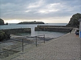
Mullion Cove
Mullion Cove is a harbour on the Lizard peninsula in south Cornwall, United Kingdom. It is situated facing west into Mount's Bay approximately six miles south of Helston and one mile southwest of Mullion village....
and Predannack to the southwest; Trewoon and Meaver to the east. Mullion is bordered by the parishes of Gunwalloe
Gunwalloe
Gunwalloe is a coastal civil parish and a village in Cornwall, United Kingdom. It is situated on the Lizard Peninsula three miles south of Helston and partly contains The Loe, the largest natural freshwater lake in Cornwall.-History:...
and Cury
Cury
Cury is a civil parish and village in southwest Cornwall, United Kingdom. It is situated approximately four miles south of Helston on The Lizard peninsula. The parish is named for St Corentin and is recorded in the Domesday Book as Chori....
to the north, Grade-Ruan
Grade-Ruan
Grade–Ruan is a civil parish on the Lizard peninsula in Cornwall, England, United Kingdom approximately ten miles south of Falmouth....
to the east, Landewednack
Landewednack
Landewednack is a civil parish and a hamlet in Cornwall, United Kingdom. The hamlet is situated approximately ten miles south of Helston.Landewednack is the most southerly parish on the British mainland...
to the south, and by the sea to the west.
The parish also includes Mullion Island
Mullion Island
Mullion Island is an uninhabited island about half a mile offshore from Mullion in Cornwall, in the south west of England, UK.The island is owned by the National Trust and is occupied by large colonies of seabirds...
, a uninhabited island approximately half a mile (0.8 km) offshore from Mullion Cove. The island is home to large colonies of seabirds and owned by the National Trust
National Trust for Places of Historic Interest or Natural Beauty
The National Trust for Places of Historic Interest or Natural Beauty, usually known as the National Trust, is a conservation organisation in England, Wales and Northern Ireland...
.
History
Mullion parish is also important historically, with evidence of prehistoric burial mounds, Celtic crosses and ancient chapel sites, and in more recent times evidence of copper and china clay mining and a World War II airfield at PredannackPredannack Airfield
Predannack Airfield is situated near Mullion on Cornwall's Lizard Peninsula in the United Kingdom. The runways are operated by the Royal Navy and today it is used as a satellite airfield and relief landing ground for nearby RNAS Culdrose.-World War II:...
. Today Mullion is the largest village on the Lizard Peninsula and is an important centre for local services and amenities as well as a popular tourist destination. Mullion School
Mullion School
Mullion School of Performing Arts is a secondary school in Mullion, which is on the Lizard Peninsula in Cornwall, England. The year groups range from year seven to year eleven, meaning there is no sixth form. It is the second smallest secondary school in England.-Special Status:Mullion School is a...
is the local secondary school.
The Royal National Lifeboat Institution
Royal National Lifeboat Institution
The Royal National Lifeboat Institution is a charity that saves lives at sea around the coasts of Great Britain, Ireland, the Channel Islands and the Isle of Man, as well as on selected inland waterways....
stationed a lifeboat
Lifeboat (rescue)
A rescue lifeboat is a boat rescue craft which is used to attend a vessel in distress, or its survivors, to rescue crewmen and passengers. It can be hand pulled, sail powered or powered by an engine...
at Mullion in 1867 but it was withdrawn in 1908. The boat house has since been demolished but its barometer
Barometer
A barometer is a scientific instrument used in meteorology to measure atmospheric pressure. Pressure tendency can forecast short term changes in the weather...
is on display in the village.
Geography
Area of Outstanding Natural Beauty
An Area of Outstanding Natural Beauty is an area of countryside considered to have significant landscape value in England, Wales or Northern Ireland, that has been specially designated by the Countryside Agency on behalf of the United Kingdom government; the Countryside Council for Wales on...
(AONB) and three designated Sites of Special Scientific Interest
Site of Special Scientific Interest
A Site of Special Scientific Interest is a conservation designation denoting a protected area in the United Kingdom. SSSIs are the basic building block of site-based nature conservation legislation and most other legal nature/geological conservation designations in Great Britain are based upon...
(SSSIs) are within the parish boundary – West Lizard SSSI, Baulk Head to Mullion
Baulk Head to Mullion
Baulk Head to Mullion is a coastal Site of Special Scientific Interest in Cornwall, England, UK, noted for both its biological and geological interest.-Geography:...
SSSI and Mullion Cliff to Predannack Cliff SSSI, which includes Mullion Island
Mullion Island
Mullion Island is an uninhabited island about half a mile offshore from Mullion in Cornwall, in the south west of England, UK.The island is owned by the National Trust and is occupied by large colonies of seabirds...
. Mullion Cliff to Predannack Cliff SSSI is noted for its geological
Geology of Cornwall
The Geology of Cornwall is dominated by its granite backbone, part of the Cornubian batholith, formed during the Variscan orogeny. Around this is an extensive metamorphic aureole formed in the mainly Devonian slates that make up most of the rest of the county...
and biological
Flora and fauna of Cornwall
Cornwall is the county that forms the tip of the southwestern peninsula of England; this area has a mild and warm climate regulated by the Gulf Stream...
interest and contains 10 Red Data Book of rare and endangered plant species
IUCN Red List
The IUCN Red List of Threatened Species , founded in 1963, is the world's most comprehensive inventory of the global conservation status of biological species. The International Union for Conservation of Nature is the world's main authority on the conservation status of species...
.
Much of the Lizard National Nature Reserve
National Nature Reserves in England
National Nature Reserves in England are managed by Natural England and are key places for wildlife and natural features in England. They were established to protect the most important areas of habitat and of geological formations...
(NNR) is within the parish boundary.
Predannack Downs
Predannack Airfield
Predannack Airfield is situated near Mullion on Cornwall's Lizard Peninsula in the United Kingdom. The runways are operated by the Royal Navy and today it is used as a satellite airfield and relief landing ground for nearby RNAS Culdrose.-World War II:...
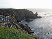
, now a satellite of nearby RNAS Culdrose . The southern extent of the parish is marked by a steep and narrow river valley cut into the downs, meeting the sea at Kynance Cove. The coastline along the edge of the Downs between Kynance Cove
Kynance Cove
Kynance Cove is a cove in southwest Cornwall, United Kingdom. It is situated on the Lizard peninsula approximately two miles north of Lizard Point...
and Mullion Cove consists of high dramatic sheer cliffs with the exception of a deep narrow cleft cut into the Downs at Gew-graze, also known as Soapy Cove. This cove is named after Soapstone
Soapstone
Soapstone is a metamorphic rock, a talc-schist. It is largely composed of the mineral talc and is thus rich in magnesium. It is produced by dynamothermal metamorphism and metasomatism, which occurs in the areas where tectonic plates are subducted, changing rocks by heat and pressure, with influx...
, a type of Serpentine rock found around the cove which was quarried near here in the 18th century.
Mullion Village
The parish comprises 5007 acres (20 km²) of land, 8 acres (32,374.9 m²) of water and 55 acres (222,577.3 m²) of foreshore . The main village of Mullion is situated in the north of the parish, approximately 65 metres above sea level and about 1 miles (2 km) inland of the coast which is to its west. The village sits at the end of two river valleys which run southwest from the village, descending steeply to meet the sea at Polurrian Cove and Mullion Cove. North of the village is a third river valley descending west to east and meeting the sea at Poldhu Cove. This river defines the boundary between Mullion and the neighbouring parish of Gunwalloe. The geology of this part of the parish consists mainly of Hornblende SchistsSchist
The schists constitute a group of medium-grade metamorphic rocks, chiefly notable for the preponderance of lamellar minerals such as micas, chlorite, talc, hornblende, graphite, and others. Quartz often occurs in drawn-out grains to such an extent that a particular form called quartz schist is...
, only changing to slate
Slate
Slate is a fine-grained, foliated, homogeneous metamorphic rock derived from an original shale-type sedimentary rock composed of clay or volcanic ash through low-grade regional metamorphism. The result is a foliated rock in which the foliation may not correspond to the original sedimentary layering...
north of Poldhu Cove. The land around the village and on the upper slopes of the river valleys is mostly fertile land cultivated for arable crops and livestock grazing. The small hamlets of Trewoon and Meaver are situated about half a mile to the east of Mullion village.
Etymology
The parish name has evolved over the years, with references in the parish records to St Mullyon, St Mullian, Mullian, Mullyan, Mulion, Mullyon and St Mullion. In the Valor EcclesiasticusValor Ecclesiasticus
The Valor Ecclesiasticus was a survey of the finances of the church in England, Wales and English controlled parts of Ireland made in 1535 on the orders of Henry VIII....
carried out in 1535 the village name is recorded as Melyan.
The parish takes its name from Saint Melaine
Melaine
Saint Melaine was a 6th century Bishop of Rennes in Brittany .-Traditional history:...
, the Breton
Breton people
The Bretons are an ethnic group located in the region of Brittany in France. They trace much of their heritage to groups of Brythonic speakers who emigrated from southwestern Great Britain in waves from the 3rd to 6th century into the Armorican peninsula, subsequently named Brittany after them.The...
Bishop of Rennes who supposedly took office in 519. He was a man of many aliases including the Latin
Latin
Latin is an Italic language originally spoken in Latium and Ancient Rome. It, along with most European languages, is a descendant of the ancient Proto-Indo-European language. Although it is considered a dead language, a number of scholars and members of the Christian clergy speak it fluently, and...
version, Saint Melanius. Reference to early publications and the 1908 Ordnance Survey maps show that the parish church
Church of England parish church
A parish church in the Church of England is the church which acts as the religious centre for the people within the smallest and most basic Church of England administrative region, known as a parish.-Parishes in England:...
was actually known as St Melan's until at least the start of the 20th Century.
In the late 19th century, Edmund Harvey, Vicar of Mullion, proposed that the parish took its name from 'Mellon' which he believed was an alias of Saint Malo. Saint Malo was a Welshman
Welsh people
The Welsh people are an ethnic group and nation associated with Wales and the Welsh language.John Davies argues that the origin of the "Welsh nation" can be traced to the late 4th and early 5th centuries, following the Roman departure from Britain, although Brythonic Celtic languages seem to have...
who moved to Brittany (possibly with his cousin, Saint Samson
Samson of Dol
Saint Samson of Dol was a Christian religious figure who is counted among the seven founder saints of Brittany. Born in southern Wales, he died in Dol-de-Bretagne, a small town in north Brittany.-Life:...
) where he became Bishop of Aleth (the region now called Saint-Malo
Saint-Malo
Saint-Malo is a walled port city in Brittany in northwestern France on the English Channel. It is a sub-prefecture of the Ille-et-Vilaine.-Demographics:The population can increase to up to 200,000 in the summer tourist season...
) around AD 541. Harvey's ideas have since been discredited. However, an area near one of the ancient chapel sites was known as St Malo's Moor in Harvey's time, and nearby were two fields known as Sampson's Crofts.
Parish church
The church is of 13th century foundation but the fabric is almost entirely of the 15th century. Features of interest include the fine series of bench ends and other old woodwork.Language
Mullion was surveyed for the Survey of English DialectsSurvey of English Dialects
The Survey of English Dialects was undertaken between 1950 and 1961 under the direction of Professor Harold Orton of the English department of the University of Leeds. It aimed to collect the full range of speech in England and Wales before local differences were to disappear...
.
Notable residents
- PrivateerPrivateerA privateer is a private person or ship authorized by a government by letters of marque to attack foreign shipping during wartime. Privateering was a way of mobilizing armed ships and sailors without having to spend public money or commit naval officers...
James EriseyJames EriseyJames Erisey was born at Erisey House near Mullion, in the parish of Grade in Cornwall. He sailed as a privateer with Sir Francis Drake.In 1585 Drake hired James Erisey to captain a man-o-war, following a message from Queen Elizabeth I that "privateers were at liberty to attack Spanish shipping".In...
was born at Erisey House near Mullion: he accompanied Francis DrakeFrancis DrakeSir Francis Drake, Vice Admiral was an English sea captain, privateer, navigator, slaver, and politician of the Elizabethan era. Elizabeth I of England awarded Drake a knighthood in 1581. He was second-in-command of the English fleet against the Spanish Armada in 1588. He also carried out the...
on three occasions - Fighter pilot and author Geoffrey Wellum DFC