
Muara, Brunei
Encyclopedia
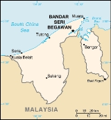
Muara is a town in the Brunei and Muara district, Brunei
. It contains the country's only deep-water port. Muara is the Malay
word for estuary
.
 Muara Town or Pekan Muara is located in Mukim Serasa and is located on the easternmost tip of West Brunei. It lends its name to the district which it is in, the Brunei-Muara district. To the North is the South China Sea
, to the south the Brunei Bay
and across the bay, Pulau Muara Besar. To the east, across a man-made channel is the remains of Tanjung Pelumpong (Cape Pelumpong), now an island. To the west is the rest of the Brunei-Muara
district
. Serasa lies to the south-west of Muara.
For the purpose of this article, Muara includes the area from Kampong Sabun to the channel at Tanjung Pelumpong north of Serasa.
fishermen.
The development of the Serai Pimping area for coal extraction in 1883 for steamships, and later settlement of the area as Brooketon by Charles Brooke, the White Rajah of Sarawak
in 1889 saw rapid development of the area. Brooketon was named after the White Rajahs of Sarawak gradually lent its name to the area which was then controlled by the government of Sarawak.
The development of the Brooketon Colliery
coal mine also lead to transport and infrastructure development at Muara. A wooden railway was built to transport the coal to the safe deep-water anchorage at Muara, and wharves and jetties were built to allow steamships and barges to berth. By 1911, more than 1,447 people lived in Muara and some 30 shops had opened in the town. Brooketon was also where the first postage stamp in Brunei was used.
Politically too, even though he only had economic rights, Brooke became the de facto ruler of the area. The mine employed hundreds of miners and that required him to introduce a police force, post office and roads transforming Muara into an extraterritorial settlement an extension of Sarawak. It was not until 1921 that Muara was "returned" to Brunei. The mine closed in 1924 because of heavy financial losses caused by continuously decreasing coal prices in the world economic recession.
The Japanese
occupied Brunei during Second World War and attempted unsuccessfully to reopen the coal mine. Brooketon was the landing location of the Australian forces as part of the Borneo Campaign (1945)
at the end of the Second World War which liberated Brunei from Japanese occupation.
Under the rule of His Majesty the late Sultan Omar Ali Saifuddin, the area was developed into a deepwater port to assist in the development of the country. Since 1973, Muara Port has undergone extensive improvements. These include extensions to the wharf bringing the total length to 948 meters including 250 meters dedicated container wharf and 87 meters aggregate wharf. The overall storage space in the form of covered storage is 16,950 square meters, long storage warehouses 16,630 square meters and open storage space 5 hectares. Facilities for the dedicated container wharf covers an area of 92,034 square meters including 8,034 square meters covered areas.
These are the areas covered in this article. Other villages in Mukim Serasa (not covered in this article) include:
petroleum facilities.
Brunei Shell Marketing has a large presence in Muara with its Muara Terminal. There are numerous bottled gas
containers on the site an a number of tanks holding various products including bitumen.
Brunei Shell Petroleum has a yard along Muara Port to support their offshore operations offshore in Brunei. The jetty measures 120 metres by 48 metres and equipped with three loading facilities and 14 storage tanks.
of the Royal Brunei Armed Forces
is based in the Muara Naval Base which is located in Pekan Muara in the Tanjong Pelumpong area . The Naval Base was expanded in 1997 to include facilities to support three offshore support vessels.
and terminates at the artificial channel at Tanjong Pelumpong. It connects Muara town to Bandar Seri Begawan
.
Jalan Serasa and Jalan Persuahan branches off from Jalan Muara and connects Muara with the neighbouring community of Serasa. It enables the items manufactured in the Serasa Industrial area to be transported to Muara Port for export.
The Muara-Tutong Highway starts at a roundabout on Jalan Muara between Kampong Sungai Kebun and Kampong Meragang. It connects Muara to Jerudong
and Tutong.
Muara is served by the purple bus
es of the Eastern Line. Route numbers 33, 37, 38 and 39 connect Muara with Serasa and the rest of the country.
to what is now Muara Port to transport the coal being mined for use on the steamships.
The Muara Container Terminal was operated by the PSA International
until 1 April 2007, when it reverted back to the Brunei Government. It had one container berth with a quay length of 250m and a max draft of 12.5m.
There is an existing plan to further develop the port by the Brunei Economic Development Board, including further dredging of the Muara Cut
, the construction of additional port facilities on Pulau Muara Besar and linking the latter to the mainland with a bridge.
Brunei
Brunei , officially the State of Brunei Darussalam or the Nation of Brunei, the Abode of Peace , is a sovereign state located on the north coast of the island of Borneo, in Southeast Asia...
. It contains the country's only deep-water port. Muara is the Malay
Malay language
Malay is a major language of the Austronesian family. It is the official language of Malaysia , Indonesia , Brunei and Singapore...
word for estuary
Estuary
An estuary is a partly enclosed coastal body of water with one or more rivers or streams flowing into it, and with a free connection to the open sea....
.
Location
South China Sea
The South China Sea is a marginal sea that is part of the Pacific Ocean, encompassing an area from the Singapore and Malacca Straits to the Strait of Taiwan of around...
, to the south the Brunei Bay
Brunei Bay
Brunei Bay is the gateway to Brunei and Borneo. It is located 4°45'-5°02'N, 114°58'-115°10'E; east of Bandar Seri Begawan. The Brunei portion of the bay is in two sections separated by a finger of Sarawak about 6km wide at the coast...
and across the bay, Pulau Muara Besar. To the east, across a man-made channel is the remains of Tanjung Pelumpong (Cape Pelumpong), now an island. To the west is the rest of the Brunei-Muara
Brunei-Muara District
Brunei-Muara is the northern-most district in Brunei; it is the smallest of Brunei's four districts in term of area but by far the most populous, with over half the country's population...
district
District
Districts are a type of administrative division, in some countries managed by a local government. They vary greatly in size, spanning entire regions or counties, several municipalities, or subdivisions of municipalities.-Austria:...
. Serasa lies to the south-west of Muara.
For the purpose of this article, Muara includes the area from Kampong Sabun to the channel at Tanjung Pelumpong north of Serasa.
History
Before the 1900s, the village of Muara was inhabited by a small group of MalayMalay people
Malays are an ethnic group of Austronesian people predominantly inhabiting the Malay Peninsula, including the southernmost parts of Thailand, the east coast of Sumatra, the coast of Borneo, and the smaller islands which lie between these locations...
fishermen.
The development of the Serai Pimping area for coal extraction in 1883 for steamships, and later settlement of the area as Brooketon by Charles Brooke, the White Rajah of Sarawak
Sarawak
Sarawak is one of two Malaysian states on the island of Borneo. Known as Bumi Kenyalang , Sarawak is situated on the north-west of the island. It is the largest state in Malaysia followed by Sabah, the second largest state located to the North- East.The administrative capital is Kuching, which...
in 1889 saw rapid development of the area. Brooketon was named after the White Rajahs of Sarawak gradually lent its name to the area which was then controlled by the government of Sarawak.
The development of the Brooketon Colliery
Brooketon Colliery
Brooketon Colliery was one of the underground coal mines in Brunei. It is no longer in production and has reverted to its natural state .-Location:The Brooketon Colliery is located in Serasa...
coal mine also lead to transport and infrastructure development at Muara. A wooden railway was built to transport the coal to the safe deep-water anchorage at Muara, and wharves and jetties were built to allow steamships and barges to berth. By 1911, more than 1,447 people lived in Muara and some 30 shops had opened in the town. Brooketon was also where the first postage stamp in Brunei was used.
Politically too, even though he only had economic rights, Brooke became the de facto ruler of the area. The mine employed hundreds of miners and that required him to introduce a police force, post office and roads transforming Muara into an extraterritorial settlement an extension of Sarawak. It was not until 1921 that Muara was "returned" to Brunei. The mine closed in 1924 because of heavy financial losses caused by continuously decreasing coal prices in the world economic recession.
The Japanese
Japanese people
The are an ethnic group originating in the Japanese archipelago and are the predominant ethnic group of Japan. Worldwide, approximately 130 million people are of Japanese descent; of these, approximately 127 million are residents of Japan. People of Japanese ancestry who live in other countries...
occupied Brunei during Second World War and attempted unsuccessfully to reopen the coal mine. Brooketon was the landing location of the Australian forces as part of the Borneo Campaign (1945)
Borneo campaign (1945)
The Borneo Campaign of 1945 was the last major Allied campaign in the South West Pacific Area, during World War II. In a series of amphibious assaults between 1 May and 21 July, the Australian I Corps, under General Leslie Morshead, attacked Japanese forces occupying the island. Allied naval and...
at the end of the Second World War which liberated Brunei from Japanese occupation.
Under the rule of His Majesty the late Sultan Omar Ali Saifuddin, the area was developed into a deepwater port to assist in the development of the country. Since 1973, Muara Port has undergone extensive improvements. These include extensions to the wharf bringing the total length to 948 meters including 250 meters dedicated container wharf and 87 meters aggregate wharf. The overall storage space in the form of covered storage is 16,950 square meters, long storage warehouses 16,630 square meters and open storage space 5 hectares. Facilities for the dedicated container wharf covers an area of 92,034 square meters including 8,034 square meters covered areas.
Kampongs (Villages)
Pekan Muara can generally be further divided into the following areas:- Town Centre
- Kampong Masjid Lama to the south of the Town Centre
- Kampong Sabun to the west and north-west, including the military barracks
- Kampong Tanjung Batu
- Kampong Pelumpong, and the area towards Tanjung Pelumpong
- Muara Beach
- Muara Port
These are the areas covered in this article. Other villages in Mukim Serasa (not covered in this article) include:
- Kampong Serasa is immediately adjacent to Pekan Muara to the south-west.
- Kampong Perpindahan Serasa to the south of Kampong Serasa
- Kampong Meragang is located between the Muara-Tutong Highway and Jalan Muara
- Kampong Kapok is located along Jalan Muara west of Kampong Serasa
- Kampong Pengalayan is located along Jalan Muara south-west of Kampong Kapok
- Kampong Salar is located along Jalan Muara south-west of Kampong Pengalayan
- Kampong Bukit Kabun
Oil and Gas
Part of the deepwater port of Muara is occupied by two Royal Dutch ShellRoyal Dutch Shell
Royal Dutch Shell plc , commonly known as Shell, is a global oil and gas company headquartered in The Hague, Netherlands and with its registered office in London, United Kingdom. It is the fifth-largest company in the world according to a composite measure by Forbes magazine and one of the six...
petroleum facilities.
Brunei Shell Marketing has a large presence in Muara with its Muara Terminal. There are numerous bottled gas
Bottled gas
Bottled gas is a term used for substances which are gaseous at standard temperature and pressure and have been compressed and stored in carbon steel, stainless steel, aluminum, or composite bottles known as gas cylinders.-Gas state in cylinders:...
containers on the site an a number of tanks holding various products including bitumen.
Brunei Shell Petroleum has a yard along Muara Port to support their offshore operations offshore in Brunei. The jetty measures 120 metres by 48 metres and equipped with three loading facilities and 14 storage tanks.
Tourist attractions
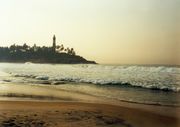
The main attraction of Pekan Muara is Muara beach (Pantai Muara in Malay) along South China Sea . The beach is about a mile long and consists of clear white sand. Amenities here include a well-equipped picnic area, a children’s playground, changing and toilet facilities, as well as weekend food and drink stalls.Military
The Royal Brunei NavyRoyal Brunei Navy
The Royal Brunei Navy is the naval defence force of Brunei Darussalam. It is a small but relatively well-equipped force whose main responsibility is to conduct search and rescue missions and to deter and defend the Brunei waters against attack mounted by sea-borne forces.The Royal Brunei Navy was...
of the Royal Brunei Armed Forces
Royal Brunei Armed Forces
The Royal Brunei Armed Forces was formed on 31 May 1961. Known as the Askar Melayu Brunei, it was honoured with the royal title on 31 May 1965, when the word 'Diraja' was added to the title. It was then known as Askar Melayu Diraja Brunei,...
is based in the Muara Naval Base which is located in Pekan Muara in the Tanjong Pelumpong area . The Naval Base was expanded in 1997 to include facilities to support three offshore support vessels.
Road
Jalan Muara is the main road that passes through Pekan Muara. It originates in Mukim Berakas near the Brunei International AirportBrunei International Airport
Brunei International Airport is the primary airport in the nation of Brunei. The Royal Brunei Air Force is also based at the Rimba Air Base which is located in the Brunei International Airport...
and terminates at the artificial channel at Tanjong Pelumpong. It connects Muara town to Bandar Seri Begawan
Bandar Seri Begawan
Bandar Seri Begawan, with an estimated population 140,000 , is the capital and largest city of the Sultanate of Brunei...
.
Jalan Serasa and Jalan Persuahan branches off from Jalan Muara and connects Muara with the neighbouring community of Serasa. It enables the items manufactured in the Serasa Industrial area to be transported to Muara Port for export.
The Muara-Tutong Highway starts at a roundabout on Jalan Muara between Kampong Sungai Kebun and Kampong Meragang. It connects Muara to Jerudong
Jerudong
Jerudong is an suburb-urban area in North west of Brunei. Its population is 21,000. Jerudong is located in the South West of Brunei-Muara District It is only 24 km to Bandar Seri Begawan. Jerudong is a well known small market town.-Climate:...
and Tutong.
Muara is served by the purple bus
Bus
A bus is a road vehicle designed to carry passengers. Buses can have a capacity as high as 300 passengers. The most common type of bus is the single-decker bus, with larger loads carried by double-decker buses and articulated buses, and smaller loads carried by midibuses and minibuses; coaches are...
es of the Eastern Line. Route numbers 33, 37, 38 and 39 connect Muara with Serasa and the rest of the country.
Rail
There are no railways or light rail in Muara. A railway line used to connect the Brooketon CollieryBrooketon Colliery
Brooketon Colliery was one of the underground coal mines in Brunei. It is no longer in production and has reverted to its natural state .-Location:The Brooketon Colliery is located in Serasa...
to what is now Muara Port to transport the coal being mined for use on the steamships.
Ports
The only deepwater port of Brunei is located in Muara. Muara Port was opened for commercial operations in February 1973, and commissioned as the Ports Department on 1st. May 1974. The Ports Department took over the whole management and operations of all the Ports on 1st.January 1986, form the Royal Customs and Excise Department.The Muara Container Terminal was operated by the PSA International
PSA International
PSA International Pte Ltd, formerly Port of Singapore Authority is the second largest port operator in the world. The company's flagship operations are PSA Singapore Terminals, PSA HNN and PSA Marine...
until 1 April 2007, when it reverted back to the Brunei Government. It had one container berth with a quay length of 250m and a max draft of 12.5m.
There is an existing plan to further develop the port by the Brunei Economic Development Board, including further dredging of the Muara Cut
Tanjong Pelumpong
Tanjong Pelumpong or the Pelumpong Spit in English is the easternmost point in the Brunei-Muara district of Brunei. Despite its name, it is now an island due to the artificially constructed 50m-wide, 10m-deep Muara cut, which separated the spit from the mainland to provide access to Muara...
, the construction of additional port facilities on Pulau Muara Besar and linking the latter to the mainland with a bridge.