
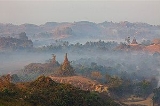
Mrauk U
Overview
Town
A town is a human settlement larger than a village but smaller than a city. The size a settlement must be in order to be called a "town" varies considerably in different parts of the world, so that, for example, many American "small towns" seem to British people to be no more than villages, while...
in northern Rakhine State
Rakhine State
Rakhine State is a Burmese state. Situated on the western coast, it is bordered by Chin State in the north, Magway Region, Bago Region and Ayeyarwady Region in the east, the Bay of Bengal to the west, and the Chittagong Division of Bangladesh to the northwest. It is located approximately between...
, Myanmar
Myanmar
Burma , officially the Republic of the Union of Myanmar , is a country in Southeast Asia. Burma is bordered by China on the northeast, Laos on the east, Thailand on the southeast, Bangladesh on the west, India on the northwest, the Bay of Bengal to the southwest, and the Andaman Sea on the south....
. It is also the capital of Mrauk-U Township
Mrauk-U Township
Mrauk-U Township is a township of Sittwe District in the Rakhine State of Myanmar. The principal town is Mrauk-U....
, a sub region of the Sittwe District
Sittwe District
Sittwe District is a district of the Rakhine State in western Myanmar. The capital lies at Sittwe-Townships:The district contains the following townships:*Sittwe Township*Ponnagyun Township*Mrauk-U Township*Kyauktaw Township*Minbya Township...
. It was the capital of Mrauk U Kingdom, the most important and powerful Rakhine
Rakhine people
The Rakhine , is a nationality in Myanmar forming the majority along the coastal region of present day Rakhine State or Arakan State. They possibly constitute 5.53% or more of Myanmar's total population but no accurate census figures exist. Rakhine people also live in the southeastern parts of...
(Arakanese) kingdom from 1433 to 1784.
Mrauk U lies roughly 11 km east of the Kaladan River
Kaladan River
The Kaladan River is a river in eastern Mizoram State of India, and in Chin State and Rakhine State of western Myanmar. It forms the international border between India and Burma between 22° 47′ 10" N and 22° 11′ 06" N.-Geography:The river arises in central Chin State as the Timit, 22° 49′ 28″ N ...
on the banks of its minor tributaries. The town is located on a small outcrop of the Rakhine Yoma on the eastern side of the Kaladan's alluvial plain.
Unanswered Questions