
Mowbray, Cape Town
Encyclopedia
Mowbray is one of the Southern Suburbs
of Cape Town
, South Africa
. Its original name was Driekoppen (In Dutch, "Three heads").
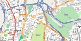
freeway, beyond which lies Devil's Peak
, and on the north by the N2
freeway, beyond which lies the suburb of Observatory
. Towards the east, the built-up area of Mowbray ends at the M5
freeway, beyond which lies the Black River and the suburb of Pinelands
; however, the official boundaries of Mowbray also include the Rondebosch and Mowbray golf course
s, which lie beyond the M5, towards Sybrand Park and Pinelands respectively. On the south, Mowbray borders on the suburb of Rosebank
with a less well-defined boundary.
The Liesbeeck River flows from south to north through Mowbray, and separates the suburb into two distinct sections. The western section lies on the lower slopes of Devil's Peak, and contains most of the commercial development in the suburb. The eastern section, known as "Little Mowbray", lies on the low hill between the Liesbeeck and Black Rivers.
The well-known Quaker Peace Centre has its offices in Mowbray.
For public transport, Mowbray is served by a station on the Metrorail
Southern Suburbs railway line. Next to the station is a large Golden Arrow
bus station with routes running out all over Cape Town, and a minibus taxi rank.
in South Africa is Mostert's Mill. It was built in 1796 and worked until the 1860s. It was restored in 1935 and again in 1995 and is open to the public one Saturday a month.
Southern Suburbs, Cape Town
The Southern Suburbs are a group of suburbs in Cape Town, Western Cape, South Africa. This group includes Rondebosch, Claremont, Plumstead, Ottery, Wynberg, Newlands, Constantia and Bishopscourt, and to some aspects Pinelands and Observatory too....
of Cape Town
Cape Town
Cape Town is the second-most populous city in South Africa, and the provincial capital and primate city of the Western Cape. As the seat of the National Parliament, it is also the legislative capital of the country. It forms part of the City of Cape Town metropolitan municipality...
, South Africa
South Africa
The Republic of South Africa is a country in southern Africa. Located at the southern tip of Africa, it is divided into nine provinces, with of coastline on the Atlantic and Indian oceans...
. Its original name was Driekoppen (In Dutch, "Three heads").
Geography
Mowbray is bounded on the west by the M3M3 (Cape Town)
The M3 is an expressway in Cape Town, South Africa, connecting the upper part of the City Bowl to the Southern Suburbs and ending in Tokai. For most of its route it parallels - though further to the south and west - the M4 , which was the original road connecting central Cape Town with the...
freeway, beyond which lies Devil's Peak
Devil's Peak (Cape Town)
Devil's Peak is part of the mountainous backdrop to Cape Town. When looking at Table Mountain from the Victoria & Alfred Waterfront, or when looking at the standard picture postcard view of the mountain, the skyline is from left to right: the spire of Devil's Peak, the flat mesa of Table Mountain,...
, and on the north by the N2
N2 (South Africa)
The N2 is a National Route in South Africa; it is the main highway along the Indian Ocean coast of the country. The N2 starts in Cape Town in the Western Cape and runs through the cities of Port Elizabeth and East London in the Eastern Cape and Durban in KwaZulu-Natal to end at Ermelo in...
freeway, beyond which lies the suburb of Observatory
Observatory, Cape Town
Observatory is a suburb in Cape Town, South Africa, bordered by Mowbray to the south, and Salt River to the north. The area is best known as student neighborhood, most of whom attend the University of Cape Town located close by, and for being the home of the South African Astronomical Observatory...
. Towards the east, the built-up area of Mowbray ends at the M5
M5 (Cape Town)
The M5 is an expressway in Cape Town, South Africa. It connects the northern suburbs to Muizenberg in the south, and crosses both the N1 and the N2...
freeway, beyond which lies the Black River and the suburb of Pinelands
Pinelands, Cape Town
The "garden city" suburb of Pinelands is located on the edge of the southern suburbs of Cape Town in South Africa and is known for its large thatched houses. The suburb is primarily residential and is often praised for its peacefulness and abundance of trees...
; however, the official boundaries of Mowbray also include the Rondebosch and Mowbray golf course
Golf course
A golf course comprises a series of holes, each consisting of a teeing ground, fairway, rough and other hazards, and a green with a flagstick and cup, all designed for the game of golf. A standard round of golf consists of playing 18 holes, thus most golf courses have this number of holes...
s, which lie beyond the M5, towards Sybrand Park and Pinelands respectively. On the south, Mowbray borders on the suburb of Rosebank
Rosebank, Cape Town
Rosebank is one of the Southern Suburbs of Cape Town, South Africa, located between the suburbs of Mowbray and Rondebosch.-Geography:Rosebank is located on the lower eastern slope of Devil's Peak, stretching down to the Liesbeeck River, and on the other side of the river up to the edge of...
with a less well-defined boundary.
The Liesbeeck River flows from south to north through Mowbray, and separates the suburb into two distinct sections. The western section lies on the lower slopes of Devil's Peak, and contains most of the commercial development in the suburb. The eastern section, known as "Little Mowbray", lies on the low hill between the Liesbeeck and Black Rivers.
The well-known Quaker Peace Centre has its offices in Mowbray.
Transport
Mowbray is well-connected to the road network, being bounded (as described above) by the M3, M5 and N2 freeways. Apart from the freeways, the main roads in the suburb are Main Road (M4) and Liesbeeck Parkway (M57), which run north-south; Victoria Road/St. Peter's Road/Durban Road/Klipfontein Road (M18) which runs west-east; and Raapenberg Road (M52) which runs to the north-east towards Pinelands.For public transport, Mowbray is served by a station on the Metrorail
Metrorail (Western Cape)
Metrorail Western Cape is a network of commuter and suburban rail services in the metropolitan area of Cape Town, South Africa. It is operated by Metrorail, which operates commuter rail service in the major cities of South Africa...
Southern Suburbs railway line. Next to the station is a large Golden Arrow
Golden Arrow Bus Services
The Golden Arrow Bus Services Ltd is an operator of public transport system for the Cape Peninsula and surrounding areas of South Africa. Its services are primarily short-routes....
bus station with routes running out all over Cape Town, and a minibus taxi rank.
Windmill
The only complete windmillWindmill
A windmill is a machine which converts the energy of wind into rotational energy by means of vanes called sails or blades. Originally windmills were developed for milling grain for food production. In the course of history the windmill was adapted to many other industrial uses. An important...
in South Africa is Mostert's Mill. It was built in 1796 and worked until the 1860s. It was restored in 1935 and again in 1995 and is open to the public one Saturday a month.