
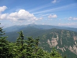
Mount Webster
Encyclopedia
Mount Webster is a mountain
located on the border between Coos County
and Carroll County
, New Hampshire
. The mountain, formerly called Notch Mountain, is named after Daniel Webster
(1782–1852), and is the southwesternmost of the Presidential Range
of the White Mountains
. Mount Webster is flanked to the northeast by Mount Jackson
; to the southwest it faces Mount Willey
across Crawford Notch
.
The west face of Mount Webster drains directly into the Saco River
, thence into the Gulf of Maine
at Saco, Maine
. The north and southeast faces drain into the Saco via Silver Cascade and Webster Brook respectively.
Mount Webster is on the western boundary of the Presidential Range - Dry River Wilderness. The Appalachian Trail
, a 2,170-mile (3,500-km) National Scenic Trail
from Georgia
to Maine
, runs along the ridge of the Presidentials, across the summit of Webster.
Mountain
Image:Himalaya_annotated.jpg|thumb|right|The Himalayan mountain range with Mount Everestrect 58 14 160 49 Chomo Lonzorect 200 28 335 52 Makalurect 378 24 566 45 Mount Everestrect 188 581 920 656 Tibetan Plateaurect 250 406 340 427 Rong River...
located on the border between Coos County
Coos County, New Hampshire
-National protected areas:*Umbagog National Wildlife Refuge *Silvio O. Conte National Fish and Wildlife Refuge *White Mountain National Forest -Demographics:...
and Carroll County
Carroll County, New Hampshire
-Demographics:As of the census of 2000, there were 43,666 people, 18,351 households, and 12,313 families residing in the county. The population density was 18/km² . There were 34,750 housing units at an average density of 14/km²...
, New Hampshire
New Hampshire
New Hampshire is a state in the New England region of the northeastern United States of America. The state was named after the southern English county of Hampshire. It is bordered by Massachusetts to the south, Vermont to the west, Maine and the Atlantic Ocean to the east, and the Canadian...
. The mountain, formerly called Notch Mountain, is named after Daniel Webster
Daniel Webster
Daniel Webster was a leading American statesman and senator from Massachusetts during the period leading up to the Civil War. He first rose to regional prominence through his defense of New England shipping interests...
(1782–1852), and is the southwesternmost of the Presidential Range
Presidential Range
The Presidential Range is a mountain range located in the White Mountains of the U.S. state of New Hampshire. Containing the highest peaks of the Whites, its most notable summits are named for American Presidents, followed by prominent public figures of the 18th and 19th centuries.Mt...
of the White Mountains
White Mountains (New Hampshire)
The White Mountains are a mountain range covering about a quarter of the state of New Hampshire and a small portion of western Maine in the United States. Part of the Appalachian Mountains, they are considered the most rugged mountains in New England...
. Mount Webster is flanked to the northeast by Mount Jackson
Mount Jackson (New Hampshire)
Mount Jackson is a mountain located in Coos County, New Hampshire. The mountain is named after Charles Thomas Jackson, New Hampshire's state geologist in the 19th century, and is part of the Presidential Range of the White Mountains. Mt...
; to the southwest it faces Mount Willey
Mount Willey
Mount Willey is a mountain located in Grafton County, New Hampshire. The mountain is named after Samuel Willey, Jr. and his family, who in 1825 moved into a house in Crawford Notch...
across Crawford Notch
Crawford Notch
Crawford Notch is the steep and narrow gorge of the Saco River in the White Mountains of New Hampshire, located almost entirely within the town of Hart's Location...
.
The west face of Mount Webster drains directly into the Saco River
Saco River
The Saco River is a river in northeastern New Hampshire and southwestern Maine in the United States. It drains a rural area of of forests and farmlands west and southwest of Portland, emptying into the Atlantic Ocean at Saco Bay, from its source. It supplies drinking water to roughly 250,000...
, thence into the Gulf of Maine
Gulf of Maine
The Gulf of Maine is a large gulf of the Atlantic Ocean on the east coast of North America.It is delineated by Cape Cod at the eastern tip of Massachusetts in the southwest and Cape Sable at the southern tip of Nova Scotia in the northeast. It includes the entire coastlines of the U.S...
at Saco, Maine
Saco, Maine
Saco is a city in York County, Maine, United States. The population was 18,482 at the 2010 census. It is home to Ferry Beach State Park, Funtown Splashtown USA, Thornton Academy, as well as General Dynamics Armament Systems , a subsidiary of the defense contractor General Dynamics...
. The north and southeast faces drain into the Saco via Silver Cascade and Webster Brook respectively.
Mount Webster is on the western boundary of the Presidential Range - Dry River Wilderness. The Appalachian Trail
Appalachian Trail
The Appalachian National Scenic Trail, generally known as the Appalachian Trail or simply the AT, is a marked hiking trail in the eastern United States extending between Springer Mountain in Georgia and Mount Katahdin in Maine. It is approximately long...
, a 2,170-mile (3,500-km) National Scenic Trail
National Scenic Trail
National Scenic Trail is a designation for protected areas in the United States that consist of trails of particular natural beauty.National Scenic Trails were authorized under the National Trails System Act of 1968 along with National Historic Trails and National Recreation Trails...
from Georgia
Georgia (U.S. state)
Georgia is a state located in the southeastern United States. It was established in 1732, the last of the original Thirteen Colonies. The state is named after King George II of Great Britain. Georgia was the fourth state to ratify the United States Constitution, on January 2, 1788...
to Maine
Maine
Maine is a state in the New England region of the northeastern United States, bordered by the Atlantic Ocean to the east and south, New Hampshire to the west, and the Canadian provinces of Quebec to the northwest and New Brunswick to the northeast. Maine is both the northernmost and easternmost...
, runs along the ridge of the Presidentials, across the summit of Webster.