
.gif)
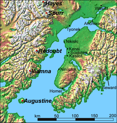
Mount Redoubt (Alaska)
Encyclopedia
Stratovolcano
A stratovolcano, also known as a composite volcano, is a tall, conical volcano built up by many layers of hardened lava, tephra, pumice, and volcanic ash. Unlike shield volcanoes, stratovolcanoes are characterized by a steep profile and periodic, explosive eruptions...
in the largely volcanic Aleutian Range
Aleutian Range
The Aleutian Range is a major mountain range of southwest Alaska, extending from Chakachamna Lake to Unimak Island, at the tip of the Alaska Peninsula. It includes all of the mountains of the Peninsula. It is especially notable for its large number of active volcanoes, which are also part of the...
of the U.S. state
U.S. state
A U.S. state is any one of the 50 federated states of the United States of America that share sovereignty with the federal government. Because of this shared sovereignty, an American is a citizen both of the federal entity and of his or her state of domicile. Four states use the official title of...
of Alaska
Alaska
Alaska is the largest state in the United States by area. It is situated in the northwest extremity of the North American continent, with Canada to the east, the Arctic Ocean to the north, and the Pacific Ocean to the west and south, with Russia further west across the Bering Strait...
. Located in the Chigmit Mountains
Chigmit Mountains
The Chigmit Mountains are a subrange of the Aleutian Range in the Kenai Peninsula and Lake and Peninsula Boroughs of the U.S. state of Alaska.-Location:...
(a subrange of the Aleutians), the mountain
Mountain
Image:Himalaya_annotated.jpg|thumb|right|The Himalayan mountain range with Mount Everestrect 58 14 160 49 Chomo Lonzorect 200 28 335 52 Makalurect 378 24 566 45 Mount Everestrect 188 581 920 656 Tibetan Plateaurect 250 406 340 427 Rong River...
is just west of Cook Inlet
Cook Inlet
Cook Inlet stretches from the Gulf of Alaska to Anchorage in south-central Alaska. Cook Inlet branches into the Knik Arm and Turnagain Arm at its northern end, almost surrounding Anchorage....
, in the Kenai Peninsula Borough
Kenai Peninsula Borough, Alaska
-National protected areas:* Alaska Maritime National Wildlife Refuge ** Chiswell Islands** Tuxedni Wilderness* Chugach National Forest * Katmai National Park and Preserve ** Katmai Wilderness...
about 180 km (110 mi) southwest of Anchorage
Anchorage, Alaska
Anchorage is a unified home rule municipality in the southcentral part of the U.S. state of Alaska. It is the northernmost major city in the United States...
. Mount Redoubt towers 9,000 feet (2,700 m) above the surrounding valleys to the north, south, and southeast in little over 5 miles (8 km); it is also the third highest within the range, with nearby Mount Torbert, at 11,413 feet, being the highest and Mount Spurr
Mount Spurr
Mount Spurr is a stratovolcano in the Aleutian Volcanic Arc of Alaska, named after United States Geological Survey geologist and explorer Josiah Edward Spurr, who led an expedition to the area in 1898...
at 11,070 feet being the second highest.
Active for millennia, Mount Redoubt has erupted five times since 1900: in 1902, 1922, 1966, 1989 and 2009. The eruption in 1989 spewed volcanic ash
Volcanic ash
Volcanic ash consists of small tephra, which are bits of pulverized rock and glass created by volcanic eruptions, less than in diameter. There are three mechanisms of volcanic ash formation: gas release under decompression causing magmatic eruptions; thermal contraction from chilling on contact...
to a height of 45,000 ft (14,000 m) and caught KLM Flight 867
KLM Flight 867
On 15 December 1989, KLM Flight 867 en route to Narita International Airport, Tokyo from Amsterdam was descending into Anchorage International Airport, Alaska when all four engines failed...
, a Boeing 747
Boeing 747
The Boeing 747 is a wide-body commercial airliner and cargo transport, often referred to by its original nickname, Jumbo Jet, or Queen of the Skies. It is among the world's most recognizable aircraft, and was the first wide-body ever produced...
aircraft, in its plume (the flight landed safely at Anchorage
Ted Stevens Anchorage International Airport
-Top destinations:-Scheduled cargo airlines:-Top destinations:-Scheduled cargo airlines:-Top destinations:-Scheduled cargo airlines:-Inter-terminal:...
). The ash blanketed an area of about 7,700 sq mi (20,000 km2). The 1989 eruption is also notable for being the first ever volcanic eruption to be successfully predicted by the method of long-period seismic events developed by Swiss/American volcanologist Bernard Chouet
Bernard Chouet
Bernard A. Chouet is a geophysicist who specializes in volcanic seismology. He discovered that volcanic eruptions could be predicted by observing the frequency of certain seismic waves that are generated by volcanoes.- Background :...
. The Alaska Volcano Observatory
Alaska Volcano Observatory
The Alaska Volcano Observatory is a joint program of the United States Geological Survey, the Geophysical Institute of the University of Alaska Fairbanks, and the State of Alaska Division of Geological and Geophysical Surveys...
currently rates Redoubt as Aviation Alert Level
Volcano warning schemes
- USGS Volcano Warning Scheme for the United States :The United States Geological Survey has adopted a common system nationwide for characterizing the level of unrest and eruptive activity at volcanoes...
Green and Volcano Alert Level
Volcano warning schemes
- USGS Volcano Warning Scheme for the United States :The United States Geological Survey has adopted a common system nationwide for characterizing the level of unrest and eruptive activity at volcanoes...
Advisory.
Name
The official name of the mountain is Redoubt Volcano, a translation of the RussianRussian language
Russian is a Slavic language used primarily in Russia, Belarus, Uzbekistan, Kazakhstan, Tajikistan and Kyrgyzstan. It is an unofficial but widely spoken language in Ukraine, Moldova, Latvia, Turkmenistan and Estonia and, to a lesser extent, the other countries that were once constituent republics...
name "Sopka Redutskaya", referring to, as does the word "redoubt
Redoubt
A redoubt is a fort or fort system usually consisting of an enclosed defensive emplacement outside a larger fort, usually relying on earthworks, though others are constructed of stone or brick. It is meant to protect soldiers outside the main defensive line and can be a permanent structure or a...
", "a fortified place". A local name, "Ujakushatsch", also means "fortified place", but it is difficult to determine if one name is derived from the other. The Board on Geographic Names decided on the name "Redoubt Volcano" in 1891.
The Global Volcanism Program
Global Volcanism Program
The Smithsonian Institution's Global Volcanism Program documents Earth's volcanoes and their eruptive history over the past 10,000 years. The GVP reports on current eruptions from around the world as well as maintaining a database repository on active volcanoes and their eruptions. In this way, a...
of the Smithsonian Institution
Smithsonian Institution
The Smithsonian Institution is an educational and research institute and associated museum complex, administered and funded by the government of the United States and by funds from its endowment, contributions, and profits from its retail operations, concessions, licensing activities, and magazines...
refers to the mountain simply as "Redoubt", and lists the following as alternate names: Burnt Mountain, Goreloi, Mirando, Ujakushatsch, Viesokaia, and Yjakushatsch. The Alaska Volcano Observatory
Alaska Volcano Observatory
The Alaska Volcano Observatory is a joint program of the United States Geological Survey, the Geophysical Institute of the University of Alaska Fairbanks, and the State of Alaska Division of Geological and Geophysical Surveys...
also uses simply "Redoubt"; it lists the same alternate names and also these: Redoubt, Mt.; Goryalaya; Redoute Mtn.; and Redutskaya, Sopka.
Geology
The volcano is about 3.7 miles (6 km) in diameter at its base with a rough volume of 7.2 to-. The sides of the upper cone are relatively steep (in comparison to volcanoes in general). Made up of pyroclastic flow deposits and lava flows, and resting on Mesozoic era rocks of the Aleutian Mountain Range batholithBatholith
A batholith is a large emplacement of igneous intrusive rock that forms from cooled magma deep in the Earth's crust...
, the mountain has been somewhat weathered
Weathering
Weathering is the breaking down of rocks, soils and minerals as well as artificial materials through contact with the Earth's atmosphere, biota and waters...
by movement of several glaciers that reside on it. The current main vent is on the north side of the crater by the head of the Drift glacier. Also present on the mountain are Holocene
Holocene
The Holocene is a geological epoch which began at the end of the Pleistocene and continues to the present. The Holocene is part of the Quaternary period. Its name comes from the Greek words and , meaning "entirely recent"...
lahar
Lahar
A lahar is a type of mudflow or debris flow composed of a slurry of pyroclastic material, rocky debris, and water. The material flows down from a volcano, typically along a river valley. The term is a shortened version of "berlahar" which originated in the Javanese language of...
deposits that extend as far as the Cook Inlet. This mountain has produced andesite
Andesite
Andesite is an extrusive igneous, volcanic rock, of intermediate composition, with aphanitic to porphyritic texture. In a general sense, it is the intermediate type between basalt and dacite. The mineral assemblage is typically dominated by plagioclase plus pyroxene and/or hornblende. Magnetite,...
, basalt
Basalt
Basalt is a common extrusive volcanic rock. It is usually grey to black and fine-grained due to rapid cooling of lava at the surface of a planet. It may be porphyritic containing larger crystals in a fine matrix, or vesicular, or frothy scoria. Unweathered basalt is black or grey...
and dacite
Dacite
Dacite is an igneous, volcanic rock. It has an aphanitic to porphyritic texture and is intermediate in composition between andesite and rhyolite. The relative proportions of feldspars and quartz in dacite, and in many other volcanic rocks, are illustrated in the QAPF diagram...
, with relatively silicic
Silicic
Silicic is a term used to describe magma or igneous rock rich in silica. The amount of silica that constitutes a silicic rock is usually put at at least 65 percent. Granite and rhyolite are typical silicic rocks....
andesite dominant in recent eruptions.
Early reports
Captain James Cook saw Mt. Redoubt during the summer of 1778 , describing it as "emitting a white smoke but no fire" which made some think it was no more than a white thick cloud such as we have frequently seen on the Coast, for the most part appearing on the sides of hills and often extends along a whole range and at different times falls or rises, expands or contracts itself and has a resemblance to Clouds of white smoke. But this besides being too small for one of those clouds, remained as it were fixed in the same spot for the whole time the Mountain was clear which was above 48 hours." However, several sources call this a "discredited eruption". There are several other of these activities that are not called eruptions.In 1819, smoke was observed at the mountain. However, this is often not recorded as an eruption as the information was insufficient to identify it as such. Similarly, in 2003, a blowing cloud of snow was mistaken by an employee of the ConocoPhillips
ConocoPhillips
ConocoPhillips Company is an American multinational energy corporation with its headquarters located in the Energy Corridor district of Houston, Texas in the United States...
Building in Anchorage for an ash plume
Eruption column
An eruption column consists of hot volcanic ash emitted during an explosive volcanic eruption. The ash forms a column rising many kilometres into the air above the peak of the volcano. In the most explosive eruptions, the eruption column may rise over 40 km, penetrating the stratosphere...
. Possible steam-vapor let off was observed in 1933 at the mountain.


1881
There was apparently an eruption described as "to the eastward, Redoubt Volcano, 11060 feet (3,371.1 m) high, is constantly smoking, with periods of exaggerated activity. Fire has been seen issuing from its summit far out at sea. A great eruption took place in 1881, when a party of native hunters half-way up its slopes were overwhelmed by a lava-flow and only two escaped." However, this eruption is not well documented by other sources.1902
The volcano erupted rather abruptly in 1902, spewing out ash from January 18 to June 21 in the year. A local newspaper stated, "Word has just been received that Redoubt, one of the volcanoes at Cook's Inlet had an eruption on January 18, and the country for 150 miles (241.4 km) around was covered with ashes and lava. The news comes from Sunrise, but nothing definite has been ascertained as to whether any damage was done, for no boats have as yet been in the neighborhood of the volcano." There were many other news reports on the eruption, one describing the eruption as "a terrific earthquake which burst the mountain asunder leaving a large gap," which could possibly suggest the crack formation in the volcano's crater, however, it is unlikely. Supposedly, the volcano was ejecting "flames" from its calderaCaldera
A caldera is a cauldron-like volcanic feature usually formed by the collapse of land following a volcanic eruption, such as the one at Yellowstone National Park in the US. They are sometimes confused with volcanic craters...
, and the eruption terrified natives in the area. Newspapers seemed to suggest that the ash had traveled for more than 150 miles (241.4 km), reaching the opposite side of the Cook Inlet
Cook Inlet
Cook Inlet stretches from the Gulf of Alaska to Anchorage in south-central Alaska. Cook Inlet branches into the Knik Arm and Turnagain Arm at its northern end, almost surrounding Anchorage....
.
1989–1990
The volcano erupted on December 14, 1989, and continued to erupt for over six months. Sudden melting of snow and ice at the summit caused by pyroclastic flowPyroclastic flow
A pyroclastic flow is a fast-moving current of superheated gas and rock , which reaches speeds moving away from a volcano of up to 700 km/h . The flows normally hug the ground and travel downhill, or spread laterally under gravity...
s and dome collapses caused lahar
Lahar
A lahar is a type of mudflow or debris flow composed of a slurry of pyroclastic material, rocky debris, and water. The material flows down from a volcano, typically along a river valley. The term is a shortened version of "berlahar" which originated in the Javanese language of...
s, or mudflows, which flowed down the north flank of the mountain. A majority of the mudflows coursed to Cook Inlet
Cook Inlet
Cook Inlet stretches from the Gulf of Alaska to Anchorage in south-central Alaska. Cook Inlet branches into the Knik Arm and Turnagain Arm at its northern end, almost surrounding Anchorage....
, about 22 miles (35.4 km) from the volcano. The lahars entered a nearby river, worrying officials that they might destroy an oil storage facility positioned along it.
Since the lahars were produced repetitively, scientists realized that they could use these to analyze a trial period for a newly developed device proposed to measure the movement of rocks against each other. This device, now known as an Acoustic Flow Monitor, alerts nearby stations to possible lahars.
The eruption also caused an airliner (the KLM Flight 867
KLM Flight 867
On 15 December 1989, KLM Flight 867 en route to Narita International Airport, Tokyo from Amsterdam was descending into Anchorage International Airport, Alaska when all four engines failed...
) to have all four engines fail after it flew into a cloud of volcanic ash. Damage from the eruption was estimated at $160 million, the second costliest volcanic eruption in United States history.
Pre-eruption
On January 30, 2009, scientists from the Alaska Volcano ObservatoryAlaska Volcano Observatory
The Alaska Volcano Observatory is a joint program of the United States Geological Survey, the Geophysical Institute of the University of Alaska Fairbanks, and the State of Alaska Division of Geological and Geophysical Surveys...
(AVO) warned that an eruption was imminent, sending experienced Alaskans shopping for protection against a dusty shower of volcanic ash that could descend on south-central Alaska.
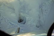
By January 31, volcanic earthquakes
Volcano tectonic earthquake
A volcano tectonic earthquake is an earthquake induced by the movement of magma. The movement results in pressure changes in the rock around where the magma has experienced stress. At some point, the rock may break or move...
increased to several per hour, and a large hole
Fumarole
A fumarole is an opening in a planet's crust, often in the neighborhood of volcanoes, which emits steam and gases such as carbon dioxide, sulfur dioxide, hydrochloric acid, and hydrogen sulfide. The steam is created when superheated water turns to steam as its pressure drops when it emerges from...
in the glacier on the side of the mountain was spotted. Scientists began to monitor seismic data from the mountain twenty-four hours a day in an effort to warn people in nearby communities. A flyover conducted by the AVO detected "significant steaming from a new melt depression at the mouth of the summit crater near the vent area of the 1989-90 eruption."
March 15
Seismic activity at Redoubt increased beginning about 13:00 ATZAlaska Time Zone
The Alaska Time Zone observes standard time by subtracting nine hours from Coordinated Universal Time . During daylight saving time its time offset is only eight hours . The clock time in this zone is based on the mean solar time of the 135th meridian west of the Greenwich Observatory.The zone...
. An AVO observation flight reported that a steam and ash plume rose as high as 15000 feet (4,572 m) above sea level and produced minor ash fall on the upper south flank of Redoubt. Later reports were that the plume was then mainly steam.
On the basis of this change in activity, AVO increased the level of concern and alert level to ORANGE/WATCH.
Emissions
The material ejected from the volcano mainly consisted of water vaporWater vapor
Water vapor or water vapour , also aqueous vapor, is the gas phase of water. It is one state of water within the hydrosphere. Water vapor can be produced from the evaporation or boiling of liquid water or from the sublimation of ice. Under typical atmospheric conditions, water vapor is continuously...
, along with smaller amounts of carbon dioxide
Carbon dioxide
Carbon dioxide is a naturally occurring chemical compound composed of two oxygen atoms covalently bonded to a single carbon atom...
and sulfur dioxide
Sulfur dioxide
Sulfur dioxide is the chemical compound with the formula . It is released by volcanoes and in various industrial processes. Since coal and petroleum often contain sulfur compounds, their combustion generates sulfur dioxide unless the sulfur compounds are removed before burning the fuel...
. Further study by airborne monitors suggests that the materials were not oxidized much, and little of the concentration contained sulfate
Sulfate
In inorganic chemistry, a sulfate is a salt of sulfuric acid.-Chemical properties:...
s, less than 20%.
Large scale eruptions begin
Mount Redoubt erupted explosively late in the evening of March 22, 2009. AVO has recorded numerous volcanic eruptions and/or explosions at Redoubt volcano.See also
- Mountain peaks of AlaskaMountain peaks of AlaskaThis article comprises three sortable tables of mountain peaks of the U.S. State of Alaska.Topographic elevation is the vertical distance above the reference geoid, a precise mathematical model of the Earth's sea level as an equipotential gravitational surface. Topographic prominence is the...
- Mountain peaks of North AmericaMountain peaks of North AmericaThis article comprises three sortable tables of major mountain peaks of greater North America.This article defines greater North America as the portion of the continental landmass of the Americas extending northward from Panama plus the islands surrounding that landmass...
- Mountain peaks of the United StatesMountain peaks of the United StatesThis article comprises three sortable tables of the major mountain peaks of the United States of America.Topographic elevation is the vertical distance above the reference geoid, a precise mathematical model of the Earth's sea level as an equipotential gravitational surface...
- List of volcanoes in the United States of America
External links and resources
- Alaska Volcano Observatory (to follow 2009 volcanic activity by geologists reports)
- Live updates from the AVO Twitter page
- Webcams:
- Redoubt Volcano Webcam, USGS (intermittently available). View of north flank of Redoubt from AVO's Redoubt Hut, approximately 7.5 mi (12 km) from Redoubt's summit crater.
- Redoubt-CI webcam, Chevron via Alaska Volcano Observatory. View of northeast face from Oil Platform Anna in Gompertz Channel of Cook Inlet at 60°58′36"N 151°18′54"W, approximately 100 km (60 mi) NE of mountain.
- Daily Time-lapse animation of the Mount Redoubt Hut Web Cam
- Mount Redoubt Seismic Webicorders (near-real time seismic record from station near peak)
- Webcams:
- Satellite imagery of the 23, 24, and 26 March 2009 eruptions (CIMSS Satellite Blog)
- Time lapse video and photos of the March 27, 2009, eruption, taken from Ninilchik
- BBC page with footage and links to other pages on the volcano
- Large-format photo essay of the Mount Redoubt eruption from "The Big Picture" blog on Boston.com.