
.gif)
Mount Pisgah (North Carolina)
Encyclopedia
Mount Pisgah is a mountain
in the Appalachian Mountain Range
and part of the Blue Ridge Mountains
of North Carolina
, United States
. The mountain's height is 5,721 feet (1,744 m) and it sits approximately 15 miles (24 kilometers) southwest of Asheville
near the crossing of the boundaries of Buncombe
, Haywood
, Henderson
and Transylvania
counties. It is located on the border of Buncombe and Haywood counties, close to the point where Henderson and Transylvania meet them, but not actually within the latter two counties. The mountain is easily accessible via a hiking trail from Blue Ridge Parkway
.
an Settlers
entered this part of North Carolina
, these mountains and valleys were the exclusive domain of Cherokee
Indians. The Cherokees had their own names for Mount Pisgah and the Pisgah Ridge. The mountain was Elseetoss and the ridge was Warwasseeta, and around them the land was rich in game and lush with trees and other plant life.
The name Pisgah comes from the Bible
, Deuteronomy
3:27. The Lord ordered Moses
to the top of this mountain and told him to look in all directions, thus revealing the Promised Land
to the tribes of Israel. There are at least two stories as to how this Biblical mountain's name came to be applied to this sylvan eminence in Western North Carolina:

The first recorded appearance of the name Mt. Pisgah in North Carolina was in 1808. In this year, part of Buncombe County was split off when Haywood County
was created, and part of the new county line was along the "ridge dividing the waters of Pigeon
and the French Broad River, to the top of Mount Pisgah."
Thomas Lanier Clingman
was a state legislator, United States Congress
man, United States Senator, Confederate
General, and somewhat given to controversy. He left his mark the history of Western North Carolina through his famous argument with Dr. Elisha Mitchell
(for whom Mt. Mitchell
was named) and his mark on the land. Clingman's Dome in the Great Smoky Mountains National Park
is named for him. He has been described as "an intrepid man of most arrogant and aggressive character, greatest self-confidence, unlimited assurance, prodigious conceit, stupendous aspiration, immense claims, more than common ability, no considerable attainment or culture, great boastfulness, and much curiosity." Mr. Clingman owned 300 acres (1.2 km²) on and around the top of Mt. Pisgah. He owned this land from the 1830s until shortly before his death in 1897, when he sold this land to George W. Vanderbilt.
George Washington Vanderbilt was the grandson of the "commodore" Cornelius Vanderbilt
. Mr. Vanderbilt began buying land south of Asheville
in 1888, and by the time he finished, he owned about 125,000 acres (506 km²), including Mt. Pisgah. Near Asheville, he built his famous Biltmore House, the grounds of which Frederick Law Olmsted
landscaped.
Two other famous names are associated with Vanderbilt and Biltmore Estate
. In 1891, Gifford Pinchot
, recently returned from studying forestry in Europe
, became Chief Forester of Biltmore. Here, with Mr. Vanderbilt's strong support, he introduced scientific forestry to the United States. In 1898, Pinchot was named head of the Forestry Division of the United States Department of Agriculture
.
Dr. Carl A. Schenck
of the University of Darmstadt
came to the United States to succeed Pinchot. When Dr. Schenck came to this country, there were fewer than half dozen trained foresters, and all had studied forestry in Europe
. There was no place in the United States to study forestry.
With George W. Vanderbilt's support, Dr. Schenck founded the Biltmore Forestry School in 1898. Classes first met in the village of Biltmore, upstairs in what is now the headquarters of the Biltmore Company. This building is a Registered National Historic Landmark
. The field school for the Biltmore Forestry School was near the foot of Mt. Pisgah. The United States Forest Service
has done an excellent reconstruction of this school at the Cradle of Forestry in America
.
In 1911, the United States Congress
passed the Weeks Act
. This monumental piece of legislation permitted the U.S. Forest Service for the first time to purchase forest lands. In 1914, the Forest Service purchased nearly 80,000 acres (320 km²), including Mt. Pisgah, from Edith Vanderbilt as a part of what is now the 479,000 acre (1940 km²) Pisgah National Forest.
In the Mount Pisgah area, the Vanderbilts kept 471 acres (1.9 km²) in Buck Springs Gap, about a mile (2 km) from Pisgah Inn. Here George W. Vanderbilt had constructed a popular log hunting lodge. The main lodge had four bedrooms, breezeway-connected building had two two-bedroom suites, and the kitchen/dining building was connected to the other two. There were several buildings near these buildings. Mr. Vanderbilt built Buck Springs Lodge just before the turn of the century, and the others were razed in 1961.
The Mt. Pisgah area has been a popular resort area for a number of years. The first Pisgah Inn opened about 1918. This rustic old Inn was a welcome journey's end for thousands of travelers escaping from the heat of the lowlands in the summer. Development of the modern Pisgah Inn began in the early 1960s. The original Inn was disassembled in 1990 due to safety concerns.
Most of the Blue Ridge Parkway
in this area was built across land transferred from the U.S. Forest Service. The exception was the 471 acres (1.9 km²) around Buck Springs Lodge. The State of North Carolina purchased the land and the lodge in 1959 and transferred the land to the United States for the construction of the Blue Ridge Parkway
. The Blue Ridge Parkway through the Mt. Pisgah area was opened for travel in the mid-1960s. The present Pisgah Inn was built in 1964.
. It is the highest television antenna east of the Mississippi River, at 2,814 feet above the surrounding valley floor, and 6,023 feet above mean sea level, according to the Federal Communications TV License Division. Co-located on the tower is WUNF-TV, PSIP Channel 33, and WKSF-FM 99.9.
On May 22, 2001, the United States Forest Service decided to allow WLOS-TV to build a replacement television transmission tower on top of Mount Pisgah. The new tower would have been a lighter-weight tower to support the station's digital antenna that would have replaced the heavier channel 13 analog antenna, fulfilling the government-ordered transfer to digital transmission
. The old tower would not have supported both the heavy analog antenna, plus the added weight of a full power digital antenna. The Blue Ridge Parkway and several conservation organizations had opposed building a new tower on the peak located adjacent to the Parkway and repeatedly requested the Forest Service explore alternative locations. In 2009, the controversy resolved itself, with the FCC
and the Department of the Interior allowing WLOS to maintain its old tower on the summit after the analog antenna was removed, and the station to make needed adjustments to its digital antennas now mounted on the tower.
 The trail leading to the summit of Mt. Pisgah starts at milepost 407 of the Blue Ridge Parkway on the west side of the road at an overlook labeled "Mt. Pisgah Parking" The trail is 1.6 miles long and is of moderate difficulty (sections near the summit can be rather steep). There is a small observation deck near the TV tower at the summit. The view is spectacular.
At the base of the TV tower, follow the huge, thick cables down to the WLOS-TV transmitter building. Leading up the mountain from the valley floor, is a still-operating cable car that is used to ferry broadcasting equipment to the building. The cable car also ferries engineers during bad weather, for mandatory transmitter work.
Also at the Mt. Pisgah Parking area is the Buck Spring trailhead. a short walk down the Buck Spring Trail brings you to a historic exhibit located at the foundation stone remains of the George Vanderbilt Hunting lodge.
On the east side of the Parkway at milepost 407 is the Mt. Pisgah Picnic Area. The picnic area includes grills, tables and restroom facilities. All are ADA/handicapped accessible.
The Pisgah Inn Lodge Restaurant and Country Store, as well as the Mt. Pisgah Campground is located at milepost 408 of the Blue Ridge Parkway. Several other trails can be accessed from the campground or the Inn.
Mountain
Image:Himalaya_annotated.jpg|thumb|right|The Himalayan mountain range with Mount Everestrect 58 14 160 49 Chomo Lonzorect 200 28 335 52 Makalurect 378 24 566 45 Mount Everestrect 188 581 920 656 Tibetan Plateaurect 250 406 340 427 Rong River...
in the Appalachian Mountain Range
Appalachian Mountains
The Appalachian Mountains #Whether the stressed vowel is or ,#Whether the "ch" is pronounced as a fricative or an affricate , and#Whether the final vowel is the monophthong or the diphthong .), often called the Appalachians, are a system of mountains in eastern North America. The Appalachians...
and part of the Blue Ridge Mountains
Blue Ridge Mountains
The Blue Ridge Mountains are a physiographic province of the larger Appalachian Mountains range. This province consists of northern and southern physiographic regions, which divide near the Roanoke River gap. The mountain range is located in the eastern United States, starting at its southern-most...
of North Carolina
North Carolina
North Carolina is a state located in the southeastern United States. The state borders South Carolina and Georgia to the south, Tennessee to the west and Virginia to the north. North Carolina contains 100 counties. Its capital is Raleigh, and its largest city is Charlotte...
, United States
United States
The United States of America is a federal constitutional republic comprising fifty states and a federal district...
. The mountain's height is 5,721 feet (1,744 m) and it sits approximately 15 miles (24 kilometers) southwest of Asheville
Asheville, North Carolina
Asheville is a city in and the county seat of Buncombe County, North Carolina, United States. It is the largest city in Western North Carolina, and the 11th largest city in North Carolina. The City is home to the United States National Climatic Data Center , which is the world's largest active...
near the crossing of the boundaries of Buncombe
Buncombe County, North Carolina
-Demographics:As of the census of 2000, there were 206,330 people, 85,776 households, and 55,668 families residing in the county. The population density was 314 people per square mile . There were 93,973 housing units at an average density of 143 per square mile...
, Haywood
Haywood County, North Carolina
-National protected areas:* Blue Ridge Parkway * Great Smoky Mountains National Park * Pisgah National Forest -Major Highways & Roads:* Interstate 40* U.S. Highway 19* U.S. Highway 23* U.S. Highway 74* U.S...
, Henderson
Henderson County, North Carolina
Henderson County is a county located in the U.S. state of North Carolina. It is part of the Asheville, North Carolina, Metropolitan Statistical Area. As of 2008, the population was 102,367. Its county seat is Hendersonville.- History :...
and Transylvania
Transylvania County, North Carolina
Transylvania County is a county located in the U.S. state of North Carolina. As of 2010, the population was 33,090. Its county seat is Brevard.- History :The county was formed in 1861 from parts of Henderson County and Jackson County...
counties. It is located on the border of Buncombe and Haywood counties, close to the point where Henderson and Transylvania meet them, but not actually within the latter two counties. The mountain is easily accessible via a hiking trail from Blue Ridge Parkway
Blue Ridge Parkway
The Blue Ridge Parkway is a National Parkway and All-American Road in the United States, noted for its scenic beauty. It runs for 469 miles , mostly along the famous Blue Ridge, a major mountain chain that is part of the Appalachian Mountains...
.
History
Before the EuropeEurope
Europe is, by convention, one of the world's seven continents. Comprising the westernmost peninsula of Eurasia, Europe is generally 'divided' from Asia to its east by the watershed divides of the Ural and Caucasus Mountains, the Ural River, the Caspian and Black Seas, and the waterways connecting...
an Settlers
British colonization of the Americas
British colonization of the Americas began in 1607 in Jamestown, Virginia and reached its peak when colonies had been established throughout the Americas...
entered this part of North Carolina
North Carolina
North Carolina is a state located in the southeastern United States. The state borders South Carolina and Georgia to the south, Tennessee to the west and Virginia to the north. North Carolina contains 100 counties. Its capital is Raleigh, and its largest city is Charlotte...
, these mountains and valleys were the exclusive domain of Cherokee
Cherokee
The Cherokee are a Native American people historically settled in the Southeastern United States . Linguistically, they are part of the Iroquoian language family...
Indians. The Cherokees had their own names for Mount Pisgah and the Pisgah Ridge. The mountain was Elseetoss and the ridge was Warwasseeta, and around them the land was rich in game and lush with trees and other plant life.
The name Pisgah comes from the Bible
Bible
The Bible refers to any one of the collections of the primary religious texts of Judaism and Christianity. There is no common version of the Bible, as the individual books , their contents and their order vary among denominations...
, Deuteronomy
Deuteronomy
The Book of Deuteronomy is the fifth book of the Hebrew Bible, and of the Jewish Torah/Pentateuch...
3:27. The Lord ordered Moses
Moses
Moses was, according to the Hebrew Bible and Qur'an, a religious leader, lawgiver and prophet, to whom the authorship of the Torah is traditionally attributed...
to the top of this mountain and told him to look in all directions, thus revealing the Promised Land
Promised land
The Promised Land is a term used to describe the land promised or given by God, according to the Hebrew Bible, to the Israelites, the descendants of Jacob. The promise is firstly made to Abraham and then renewed to his son Isaac, and to Isaac's son Jacob , Abraham's grandson...
to the tribes of Israel. There are at least two stories as to how this Biblical mountain's name came to be applied to this sylvan eminence in Western North Carolina:
- In 1776, General Griffith RutherfordGriffith RutherfordGriffith Rutherford was an officer in the American Revolutionary War, a political leader in North Carolina, and an important figure in the early history of the Southwest Territory and the state of Tennessee....
led an expedition against the CherokeeCherokeeThe Cherokee are a Native American people historically settled in the Southeastern United States . Linguistically, they are part of the Iroquoian language family...
s. Accompanying this expedition as a chaplainChaplainTraditionally, a chaplain is a minister in a specialized setting such as a priest, pastor, rabbi, or imam or lay representative of a religion attached to a secular institution such as a hospital, prison, military unit, police department, university, or private chapel...
was one James Hall. The men of the expedition saw the mountain from the French Broad RiverFrench Broad RiverThe French Broad River flows from near the village of Rosman in Transylvania County, North Carolina, into the state of Tennessee. Its confluence with the Holston River at Knoxville is the beginning of the Tennessee River....
valley and saw a rich land around it—a land of milk and honey, a promised land. James Hall, preacher and soldier, is credited with drawing the parallel with the land that Moses saw from Pisgah and applying the Biblical appellation to this mountain.
- George Newton was a Presbyterian minister who lived and taught in the late 18th and early 19th centuries at what became Newton Academy in Asheville. Reverend Newton is credited with naming Mt. Pisgah. Because of the extensive view in all directions over a rich land, Reverend Newton felt there was similarity between this mountain and the one on which Moses stood.
The first recorded appearance of the name Mt. Pisgah in North Carolina was in 1808. In this year, part of Buncombe County was split off when Haywood County
Haywood County, North Carolina
-National protected areas:* Blue Ridge Parkway * Great Smoky Mountains National Park * Pisgah National Forest -Major Highways & Roads:* Interstate 40* U.S. Highway 19* U.S. Highway 23* U.S. Highway 74* U.S...
was created, and part of the new county line was along the "ridge dividing the waters of Pigeon
Pigeon River (Tennessee - North Carolina)
The Pigeon River of western North Carolina and east Tennessee rises above Canton, North Carolina. Below this, it flows roughly parallel to Interstate 40 for many miles and is impounded by a dam -- Walters Dam -- belonging to Progress Energy before entering Tennessee, where it flows into the French...
and the French Broad River, to the top of Mount Pisgah."
Thomas Lanier Clingman
Thomas Lanier Clingman
Thomas Lanier Clingman , known as the "Prince of Politicians," was a Democratic member of the United States House of Representatives from 1843 to 1845 and from 1847 to 1858, and U.S. senator from the state of North Carolina between 1858 and 1861...
was a state legislator, United States Congress
United States Congress
The United States Congress is the bicameral legislature of the federal government of the United States, consisting of the Senate and the House of Representatives. The Congress meets in the United States Capitol in Washington, D.C....
man, United States Senator, Confederate
Confederate States of America
The Confederate States of America was a government set up from 1861 to 1865 by 11 Southern slave states of the United States of America that had declared their secession from the U.S...
General, and somewhat given to controversy. He left his mark the history of Western North Carolina through his famous argument with Dr. Elisha Mitchell
Elisha Mitchell
Elisha Mitchell was born in Washington, Connecticut. As a professor at the University of North Carolina at Chapel Hill, in 1835, he measured the height of Mt. Mitchell. Mt. Mitchell is the highest point east of the Mississippi River. It is located in North Carolina and is 6,684 feet high...
(for whom Mt. Mitchell
Mount Mitchell (North Carolina)
Mount Mitchell is the highest peak of the Appalachian Mountains and the highest peak in the eastern United States. It was the highest point in any state of the United States until Texas joined the union in 1845. The nearest higher point east of the Rocky Mountains is Harney Peak in the Black Hills...
was named) and his mark on the land. Clingman's Dome in the Great Smoky Mountains National Park
Great Smoky Mountains National Park
Great Smoky Mountains National Park is a United States National Park and UNESCO World Heritage Site that straddles the ridgeline of the Great Smoky Mountains, part of the Blue Ridge Mountains, which are a division of the larger Appalachian Mountain chain. The border between Tennessee and North...
is named for him. He has been described as "an intrepid man of most arrogant and aggressive character, greatest self-confidence, unlimited assurance, prodigious conceit, stupendous aspiration, immense claims, more than common ability, no considerable attainment or culture, great boastfulness, and much curiosity." Mr. Clingman owned 300 acres (1.2 km²) on and around the top of Mt. Pisgah. He owned this land from the 1830s until shortly before his death in 1897, when he sold this land to George W. Vanderbilt.
George Washington Vanderbilt was the grandson of the "commodore" Cornelius Vanderbilt
Cornelius Vanderbilt
Cornelius Vanderbilt , also known by the sobriquet Commodore, was an American entrepreneur who built his wealth in shipping and railroads. He was also the patriarch of the Vanderbilt family and one of the richest Americans in history...
. Mr. Vanderbilt began buying land south of Asheville
Asheville, North Carolina
Asheville is a city in and the county seat of Buncombe County, North Carolina, United States. It is the largest city in Western North Carolina, and the 11th largest city in North Carolina. The City is home to the United States National Climatic Data Center , which is the world's largest active...
in 1888, and by the time he finished, he owned about 125,000 acres (506 km²), including Mt. Pisgah. Near Asheville, he built his famous Biltmore House, the grounds of which Frederick Law Olmsted
Frederick Law Olmsted
Frederick Law Olmsted was an American journalist, social critic, public administrator, and landscape designer. He is popularly considered to be the father of American landscape architecture, although many scholars have bestowed that title upon Andrew Jackson Downing...
landscaped.
Two other famous names are associated with Vanderbilt and Biltmore Estate
Biltmore Estate
Biltmore House is a Châteauesque-styled mansion near Asheville, North Carolina, built by George Washington Vanderbilt II between 1889 and 1895. It is the largest privately-owned home in the United States, at and featuring 250 rooms...
. In 1891, Gifford Pinchot
Gifford Pinchot
Gifford Pinchot was the first Chief of the United States Forest Service and the 28th Governor of Pennsylvania...
, recently returned from studying forestry in Europe
Europe
Europe is, by convention, one of the world's seven continents. Comprising the westernmost peninsula of Eurasia, Europe is generally 'divided' from Asia to its east by the watershed divides of the Ural and Caucasus Mountains, the Ural River, the Caspian and Black Seas, and the waterways connecting...
, became Chief Forester of Biltmore. Here, with Mr. Vanderbilt's strong support, he introduced scientific forestry to the United States. In 1898, Pinchot was named head of the Forestry Division of the United States Department of Agriculture
United States Department of Agriculture
The United States Department of Agriculture is the United States federal executive department responsible for developing and executing U.S. federal government policy on farming, agriculture, and food...
.
Dr. Carl A. Schenck
Carl A. Schenck
Carl Alwyn Schenck was a pioneering forestry educator in North America, known for his contributions as the forester for George W. Vanderbilt's Biltmore Estate, and the founder of the Biltmore Forest School in 1898, near Asheville, NC....
of the University of Darmstadt
Darmstadt University of Technology
The Technische Universität Darmstadt, abbreviated TU Darmstadt, is a university in the city of Darmstadt, Germany...
came to the United States to succeed Pinchot. When Dr. Schenck came to this country, there were fewer than half dozen trained foresters, and all had studied forestry in Europe
Europe
Europe is, by convention, one of the world's seven continents. Comprising the westernmost peninsula of Eurasia, Europe is generally 'divided' from Asia to its east by the watershed divides of the Ural and Caucasus Mountains, the Ural River, the Caspian and Black Seas, and the waterways connecting...
. There was no place in the United States to study forestry.
With George W. Vanderbilt's support, Dr. Schenck founded the Biltmore Forestry School in 1898. Classes first met in the village of Biltmore, upstairs in what is now the headquarters of the Biltmore Company. This building is a Registered National Historic Landmark
National Historic Landmark
A National Historic Landmark is a building, site, structure, object, or district, that is officially recognized by the United States government for its historical significance...
. The field school for the Biltmore Forestry School was near the foot of Mt. Pisgah. The United States Forest Service
United States Forest Service
The United States Forest Service is an agency of the United States Department of Agriculture that administers the nation's 155 national forests and 20 national grasslands, which encompass...
has done an excellent reconstruction of this school at the Cradle of Forestry in America
Cradle of Forestry in America
The Cradle of Forestry in America is a 6,500 acre Historic Site within the Pisgah National Forest in Transylvania County, North Carolina. The site includes the Forest Discovery Center, which features exhibits and a movie about forestry and forest conservation history, a gift shop and cafe...
.
In 1911, the United States Congress
United States Congress
The United States Congress is the bicameral legislature of the federal government of the United States, consisting of the Senate and the House of Representatives. The Congress meets in the United States Capitol in Washington, D.C....
passed the Weeks Act
Weeks Act
The Weeks Act is a federal law passed by the US Congress on 1 March 1911 in the United States. The law, introduced by Congressman John W. Weeks of Massachusetts, authorized the Secretary of Agriculture to "Examine, locate and recommend for purchase ... such lands within the watersheds of navigable...
. This monumental piece of legislation permitted the U.S. Forest Service for the first time to purchase forest lands. In 1914, the Forest Service purchased nearly 80,000 acres (320 km²), including Mt. Pisgah, from Edith Vanderbilt as a part of what is now the 479,000 acre (1940 km²) Pisgah National Forest.
In the Mount Pisgah area, the Vanderbilts kept 471 acres (1.9 km²) in Buck Springs Gap, about a mile (2 km) from Pisgah Inn. Here George W. Vanderbilt had constructed a popular log hunting lodge. The main lodge had four bedrooms, breezeway-connected building had two two-bedroom suites, and the kitchen/dining building was connected to the other two. There were several buildings near these buildings. Mr. Vanderbilt built Buck Springs Lodge just before the turn of the century, and the others were razed in 1961.
The Mt. Pisgah area has been a popular resort area for a number of years. The first Pisgah Inn opened about 1918. This rustic old Inn was a welcome journey's end for thousands of travelers escaping from the heat of the lowlands in the summer. Development of the modern Pisgah Inn began in the early 1960s. The original Inn was disassembled in 1990 due to safety concerns.
Most of the Blue Ridge Parkway
Blue Ridge Parkway
The Blue Ridge Parkway is a National Parkway and All-American Road in the United States, noted for its scenic beauty. It runs for 469 miles , mostly along the famous Blue Ridge, a major mountain chain that is part of the Appalachian Mountains...
in this area was built across land transferred from the U.S. Forest Service. The exception was the 471 acres (1.9 km²) around Buck Springs Lodge. The State of North Carolina purchased the land and the lodge in 1959 and transferred the land to the United States for the construction of the Blue Ridge Parkway
Blue Ridge Parkway
The Blue Ridge Parkway is a National Parkway and All-American Road in the United States, noted for its scenic beauty. It runs for 469 miles , mostly along the famous Blue Ridge, a major mountain chain that is part of the Appalachian Mountains...
. The Blue Ridge Parkway through the Mt. Pisgah area was opened for travel in the mid-1960s. The present Pisgah Inn was built in 1964.
Broadcasting controversy
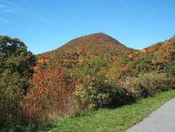
The prominent tower in the picture at the crest of Mount Pisgah on what is known as Pisgah Ledge, is a 339 feet (103.3 m) television broadcast tower owned by Chesapeake Television, Incorporated, doing business as the Sinclair Broadcast Group, licensee of WLOS-TV, PSIP Channel 13, in nearby Asheville, North CarolinaAsheville, North Carolina
Asheville is a city in and the county seat of Buncombe County, North Carolina, United States. It is the largest city in Western North Carolina, and the 11th largest city in North Carolina. The City is home to the United States National Climatic Data Center , which is the world's largest active...
. It is the highest television antenna east of the Mississippi River, at 2,814 feet above the surrounding valley floor, and 6,023 feet above mean sea level, according to the Federal Communications TV License Division. Co-located on the tower is WUNF-TV, PSIP Channel 33, and WKSF-FM 99.9.
On May 22, 2001, the United States Forest Service decided to allow WLOS-TV to build a replacement television transmission tower on top of Mount Pisgah. The new tower would have been a lighter-weight tower to support the station's digital antenna that would have replaced the heavier channel 13 analog antenna, fulfilling the government-ordered transfer to digital transmission
Digital television
Digital television is the transmission of audio and video by digital signals, in contrast to the analog signals used by analog TV...
. The old tower would not have supported both the heavy analog antenna, plus the added weight of a full power digital antenna. The Blue Ridge Parkway and several conservation organizations had opposed building a new tower on the peak located adjacent to the Parkway and repeatedly requested the Forest Service explore alternative locations. In 2009, the controversy resolved itself, with the FCC
Federal Communications Commission
The Federal Communications Commission is an independent agency of the United States government, created, Congressional statute , and with the majority of its commissioners appointed by the current President. The FCC works towards six goals in the areas of broadband, competition, the spectrum, the...
and the Department of the Interior allowing WLOS to maintain its old tower on the summit after the analog antenna was removed, and the station to make needed adjustments to its digital antennas now mounted on the tower.
Recreation
At the base of the TV tower, follow the huge, thick cables down to the WLOS-TV transmitter building. Leading up the mountain from the valley floor, is a still-operating cable car that is used to ferry broadcasting equipment to the building. The cable car also ferries engineers during bad weather, for mandatory transmitter work.
Also at the Mt. Pisgah Parking area is the Buck Spring trailhead. a short walk down the Buck Spring Trail brings you to a historic exhibit located at the foundation stone remains of the George Vanderbilt Hunting lodge.
On the east side of the Parkway at milepost 407 is the Mt. Pisgah Picnic Area. The picnic area includes grills, tables and restroom facilities. All are ADA/handicapped accessible.
The Pisgah Inn Lodge Restaurant and Country Store, as well as the Mt. Pisgah Campground is located at milepost 408 of the Blue Ridge Parkway. Several other trails can be accessed from the campground or the Inn.