Mount Lofty
Encyclopedia
Mount Lofty Ranges
The Mount Lofty Ranges are the range of mountains just to the east of Adelaide in South Australia.-Location and description:The Mount Lofty Ranges stretch from the southernmost point of the Fleurieu Peninsula at Cape Jervis northwards for over before petering out north of Peterborough...
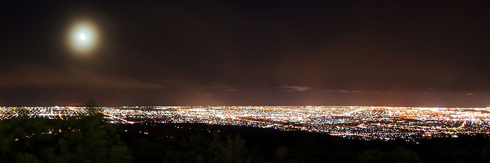
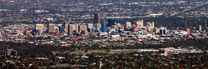
. It is located about 15km east of the centre of the city of Adelaide
Adelaide
Adelaide is the capital city of South Australia and the fifth-largest city in Australia. Adelaide has an estimated population of more than 1.2 million...
in South Australia
South Australia
South Australia is a state of Australia in the southern central part of the country. It covers some of the most arid parts of the continent; with a total land area of , it is the fourth largest of Australia's six states and two territories.South Australia shares borders with all of the mainland...
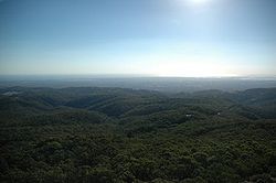
and gives unrivalled panoramic views of the city and the Adelaide plains and foothills. It was first climbed by a European when explorer Collet Barker
Collet Barker
Collet Barker was a British military officer and explorer. He explored areas of South Australia, Western Australia and Cobourg Peninsula, Northern Territory-History:Barker was born in Hackney, he lived in Newbury as a child...
climbed it in April 1831, almost seven years before Adelaide was settled. It was named by Matthew Flinders
Matthew Flinders
Captain Matthew Flinders RN was one of the most successful navigators and cartographers of his age. In a career that spanned just over twenty years, he sailed with Captain William Bligh, circumnavigated Australia and encouraged the use of that name for the continent, which had previously been...
on his circumnavigation of Australia
Australia
Australia , officially the Commonwealth of Australia, is a country in the Southern Hemisphere comprising the mainland of the Australian continent, the island of Tasmania, and numerous smaller islands in the Indian and Pacific Oceans. It is the world's sixth-largest country by total area...
in 1802.
The Summit was closed to the public during World War 2, when the obelisk was considered an indispensable navigation assistant. A flashing strobe was fitted to the top to improve visibility at night. This strobe was removed after the war, but then re-installed in the 1990s, when the obelisk was repainted and restored during construction of the new kiosk.
Access to the summit can be gained by road from the South Eastern Freeway
South Eastern Freeway
The South Eastern Freeway is a 66 kilometre four-lane divided carriageway road in South Australia linking the Adelaide-Crafers Highway to the Princes Highway at the Swanport Bridge, a one kilometre long bridge over the River Murray, near Murray Bridge...
at Crafers
Crafers, South Australia
The town of Crafers is located in the Adelaide Hills to the southeast of Adelaide, South Australia. Although technically considered to be an outer suburb of Adelaide, with many residents commuting to the city to work, locals consider Crafers to be more a suburb of the nearby township of Stirling.-...
, or from the eastern suburbs via Greenhill Road. The more enthusiastic can walk up the gully from Waterfall Gully
Waterfall Gully, South Australia
Waterfall Gully is an outer suburb of the South Australian capital city of Adelaide. It is located in the foothills of the Mount Lofty Ranges around east-south-east of Adelaide's central business district . For the most part, the suburb encompasses one long gully with First Creek at its centre and...
, in the Cleland Conservation Park
Cleland Conservation Park
Cleland Conservation Park is a conservation park in the Adelaide Hills, South Australia. from Adelaide City centre. Cleland Conservation Park conserves a significant area of natural bushland on the Adelaide Hills face and includes the internationally popular Cleland Wildlife Park and the popular...
or from Chambers Gully. The summit provides panoramic views across Adelaide, and a cafe-restaurant and gift shop. These are relatively new due to protracted disputes over appropriate development following the destruction of the old cafe in the 1983 Ash Wednesday fires
Ash Wednesday fires
The Ash Wednesday bushfires, known in South Australia as Ash Wednesday II, were a series of bushfires that occurred in south-eastern Australia on 16 February 1983. Within twelve hours, more than 180 fires fanned by winds of up to 110 km per hour caused widespread destruction across the states...
.
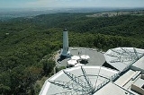
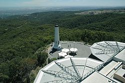
On the ridge near the summit are the television transmission towers for the Adelaide television stations, and the Mount Lofty Fire Tower
Mount Lofty Fire Tower
Mount Lofty Fire Tower sits on top of Mount Lofty in the Adelaide Hills just to the east of the city of Adelaide, South Australia. The 34m high tower has a commanding view over a huge area of the rural areas surrounding Adelaide, and on a clear day the view can extend to as far as Kangaroo Island...
operated by the Country Fire Service
Country Fire Service
The SA Country Fire Service is a volunteer based fire service in the state of South Australia in Australia. Many parts of Australia are sparsely populated whilst at the same time they are under significant risk of bushfire. Due to economics, it is prohibitively expensive for each Australian town...
.
This is becoming a popular spot for tourists to Adelaide and also for cyclists coming up the old Mount Barker Road
Adelaide-Crafers Highway
The Adelaide-Crafers Highway is a 10 kilometre controlled-access highway linking Adelaide city centre to Crafers in the Adelaide hills, and continuing from Crafers as the South Eastern Freeway. The highway is ten kilometres long, including 500 metre long twin-tube tunnels , the first of their kind...
through Eagle on the Hill
Eagle on the Hill, South Australia
Eagle On The Hill is an unbounded locality of Adelaide in the Adelaide Foothills. It borders Mount Osmond and Waterfall Gully.The village is located on Mount Barker Road, which was the only connection from Adelaide to the South Eastern Freeway. Once the Adelaide-Crafers Highway through the Heysen...
; this section of highway has now been superseded by the Heysen Tunnels
Heysen Tunnels
The Heysen Tunnels are twin tube road tunnels which carry the Adelaide-Crafers Highway under Eagle On The Hill in the Mount Lofty Ranges in South Australia. The tunnels were excavated using a tunnelling machine normally used in heavy-duty mining operations which tunnelled through 500 metres of rock...
.
Light snowfalls are not uncommon on the summit, although it is possible for Mount Lofty to go two or three years with out any snowfall. Mount Lofty is the coldest location in Adelaide, during winter months the temperature will not surpass 3-4 degrees Celsius some days. It is the most common location for snow in South Australia, with other rare snowfalls in other parts of the Mount Lofty Ranges and Northern South Australia.