

Morgantown metropolitan area
Encyclopedia
United States Census Bureau
The United States Census Bureau is the government agency that is responsible for the United States Census. It also gathers other national demographic and economic data...
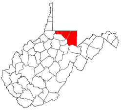
, is an area consisting of two counties in north-central
North-Central West Virginia
North-Central West Virginia is a region of the U.S. State of West Virginia. The region's largest city is Morgantown.- Counties :*Monongalia County*Marion County*Harrison County*Taylor County*Doddridge County...
West Virginia
West Virginia
West Virginia is a state in the Appalachian and Southeastern regions of the United States, bordered by Virginia to the southeast, Kentucky to the southwest, Ohio to the northwest, Pennsylvania to the northeast and Maryland to the east...
, anchored by the city of Morgantown
Morgantown, West Virginia
Morgantown is a city in Monongalia County, West Virginia. It is the county seat of Monongalia County. Placed along the banks of the Monongahela River, Morgantown is the largest city in North-Central West Virginia, and the base of the Morgantown metropolitan area...
. As of the 2000 census
United States Census, 2000
The Twenty-second United States Census, known as Census 2000 and conducted by the Census Bureau, determined the resident population of the United States on April 1, 2000, to be 281,421,906, an increase of 13.2% over the 248,709,873 persons enumerated during the 1990 Census...
, the MSA had a population of 111,200 (though a July 1, 2009 estimate placed the population at 120,327).
Counties
- MonongaliaMonongalia County, West VirginiaAs of the census of 2000, there were 81,866 people, 33,446 households, and 18,495 families residing in the county. The population density was 227 people per square mile . There were 36,695 housing units at an average density of 102 per square mile...
- PrestonPreston County, West VirginiaAs of the census of 2000, there were 29,334 people, 11,544 households, and 8,357 families residing in the county. The population density was 45 people per square mile . There were 13,444 housing units at an average density of 21 per square mile...
Incorporated places and CDPs
- Places with more than 20,000 inhabitants
- MorgantownMorgantown, West VirginiaMorgantown is a city in Monongalia County, West Virginia. It is the county seat of Monongalia County. Placed along the banks of the Monongahela River, Morgantown is the largest city in North-Central West Virginia, and the base of the Morgantown metropolitan area...
(Principal city)
- Morgantown
- Places with 5,000 to 10,000 inhabitants
- Cheat LakeCheat Lake, West VirginiaCheat Lake is a census-designated place in Monongalia County, West Virginia, United States. The population was 7,988 at the 2010 census. It is included in the Morgantown, West Virginia Metropolitan Statistical Area.-Geography:...
(census-designated placeCensus-designated placeA census-designated place is a concentration of population identified by the United States Census Bureau for statistical purposes. CDPs are delineated for each decennial census as the statistical counterparts of incorporated places such as cities, towns and villages...
)
- Cheat Lake
- Places with 1,000 to 5,000 inhabitants
- BrookhavenBrookhaven, West VirginiaBrookhaven is a census-designated place in Monongalia County, West Virginia, United States. The population was 5,171 at the 2010 census. It is included in the Morgantown, West Virginia Metropolitan Statistical Area.-Geography:...
(census-designated place) - CassvilleCassville, West VirginiaCassville is a census-designated place in Monongalia County, West Virginia, United States. The population was 701 at the 2010 census. It is included in the Morgantown, West Virginia Metropolitan Statistical Area...
(census-designated place) - KingwoodKingwood, West VirginiaKingwood is a town in and the county seat of Preston County, West Virginia, United States, and is part of the Pittsburgh DMA. Kingwood was founded in 1815...
- Terra AltaTerra Alta, West VirginiaTerra Alta is a town in Preston County, West Virginia, United States. The population was 1,456 at the 2000 census.-History:The James S. Lakin House and Terra Alta Bank are listed on the National Register of Historic Places.-Geography:...
- Star CityStar City, West VirginiaStar City is a small town in Monongalia County, West Virginia, in the United States. The population was 1,366 at the 2000 census. It is included in the Morgantown, West Virginia Metropolitan Statistical Area.-Geography:...
- WestoverWestover, West VirginiaWestover is a city in Monongalia County, West Virginia, United States. The population was 3,941 at the 2000 census. It is included in the Morgantown, West Virginia Metropolitan Statistical Area.-History:Westover was incorporated on October 12, 1911...
- Brookhaven
- Places with 500 to 1,000 inhabitants
- GranvilleGranville, West VirginiaGranville is a town in Monongalia County, West Virginia, United States. The population was 778 at the 2000 census. It is included in the Morgantown, West Virginia Metropolitan Statistical Area.-Geography:Granville is located at ....
- MasontownMasontown, West VirginiaMasontown is a town in Preston County, West Virginia, United States. The population was 647 at the 2000 census.-History:Located near Masontown is the Ralphsynder Decagonal Barn, listed on the National Register of Historic Places in 1985.-Geography:...
- ReedsvilleReedsville, West VirginiaReedsville is a town in Preston County, West Virginia, in the United States. The population was 517 at the 2000 census.Reedsville was named for James Reed, who moved to the area in 1827 and owned land covering most of the future townsite. The first house in the community was built in 1855, and the...
- RowlesburgRowlesburg, West VirginiaRowlesburg is a town in Preston County, West Virginia, United States, along the Cheat River. The population was 613 at the 2000 census.-History:The Downtown Rowlesburg Historic District was listed on the National Register of Historic Places in 2005....
- Granville
- Places with less than 1,000 inhabitants
- AlbrightAlbright, West VirginiaAlbright is a town in Preston County, West Virginia, United States, along the Cheat River. The population was 247 at the 2000 census.-History:Located near Albright is the Virginia Furnace, listed on the National Register of Historic Places in 1999....
- BlacksvilleBlacksville, West VirginiaBlacksville is a town in Monongalia County, West Virginia, USA. The population was 175 at the 2000 census. It is included in the Morgantown, West Virginia Metropolitan Statistical Area.-Geography:Blacksville is located at ....
- BrandonvilleBrandonville, West VirginiaBrandonville is a town in Preston County, West Virginia, United States. The population was 102 at the 2000 census.-History:The Hagans Homestead was listed on the National Register of Historic Places in 1993.-Geography:...
- Bruceton MillsBruceton Mills, West VirginiaBruceton Mills is a town in Preston County, West Virginia, United States along Big Sandy Creek. The population was 74 at the 2000 census. An early settler, John M. Hoffman, named this community for his stepfather, George Bruce, who claimed direct descendance from Robert the Bruce, King of Scotland....
- NewburgNewburg, West VirginiaNewburg is a town in Preston County, West Virginia, United States. The population was 360 at the 2000 census. At one time, Newburg was the largest town in Preston County.-Geography:Newburg is located at ....
- TunneltonTunnelton, West VirginiaTunnelton is a town in Preston County, West Virginia, United States. The population was 336 at the 2000 census.-History:The Tunnelton Railroad Depot was listed on the National Register of Historic Places in 1996.-Geography:...
- Albright
Unincorporated places
- AftonAfton, West VirginiaAfton is an unincorporated community in Preston County, West Virginia, United States. It lies on County Route 28....
- Alpine LakeAlpine Lake, West VirginiaAlpine Lake is a private, gated community located in Preston County, West Virginia, United States. It lies to the south of White Oak Springs and northeast of Terra Alta, West Virginia. On one side, the community runs along the actual border line between West Virginia and Maryland...
- AmboyAmboy, West VirginiaAmboy is an unincorporated community in Preston County, West Virginia, United States....
- ArnettsvilleArnettsville, West VirginiaArnettsville is an unincorporated community in Monongalia County, West Virginia, United States. It lies south of Georgetown on U.S. Route 19. Arnettsville was originally known as Yukon. It is included in the Morgantown, West Virginia Metropolitan Statistical Area.-Natives:* Mary Miller Glasscock,...
- ArthurdaleArthurdale, West VirginiaArthurdale is an unincorporated community in Preston County, West Virginia, United States. Arthurdale was named for Richard Arthur, former owner of the land on which it was built, who had sold the land to the federal government under a tax default....
- AuroraAurora, West VirginiaAurora is an unincorporated census-designated place in Preston County, West Virginia, United States. As of the 2010 census, its population was 201. Aurora was originally a German settlement. The town was originally called Salem and later Mount Carmel...
- Austen
- Baker Ridge
- Behler
- Bertha Hill
- Booth
- BorgmanBorgman, West VirginiaBorgman is an unincorporated community in Preston County, West Virginia, United States.Borgman is located three miles west southwest from Kingwood. It is 2,260 feet [689 m] above sea level....
- Bowlby
- Bretz
- Brewer Hill
- Browns Chapel
- Bula
- Canyon
- Cascade
- Cheat Neck
- Chestnut Ridge
- Clifton MillsClifton Mills, West VirginiaClifton Mills is an unincorporated community in Preston County, West Virginia, United States. A post office was opened in Clifton Mills in 1881 and operated until being discontinued on November 22, 1963....
- Clinton Furnace
- CoreCore, West VirginiaCore is an unincorporated community in Monongalia County, West Virginia, United States. Core is northwest of downtown Morgantown....
- CorinthCorinth, West VirginiaCorinth is an unincorporated community in Preston County, West Virginia, United States. Corinth was originally called Spencer but was changed in 1890 to avoid duplication of names in the state. It is named after the ancient Greek city of Corinth....
- CrossroadsCrossroads, West VirginiaCrossroads is an unincorporated community in Summers County, West Virginia, United States. Crossroads is northeast of Hinton....
- CrownCrown, Monongalia County, West VirginiaCrown is an unincorporated community in Monongalia County, West Virginia, United States. Crown is located at the junction of County Highways 26 and 37 west-southwest of Morgantown....
- Cuzzart
- DaybrookDaybrook, West VirginiaDaybrook is an unincorporated community in Monongalia County, West Virginia, United States. It is situated at a crossroads of route 218 at an altitude of 1,007 feet....
- DellslowDellslow, West VirginiaDellslow is an unincorporated community in Monongalia County, West Virginia, United States. Dellslow was established in 1798 and is located along West Virginia Route 7 near the southern border of Brookhaven. Dellslow has a post office with ZIP code 26531....
- Delmar
- DenverDenver, West VirginiaDenver is an unincorporated community in Preston County, West Virginia, United States. The Tunnelton Denver Elementary School is located along West Virginia Route 26 in Denver....
- Easton
- Edna
- EglonEglon, West VirginiaEglon is an unincorporated community in Preston County, West Virginia, United States. Its elevation is 2,628 feet . Although it is unincorporated, it has a post office, with the ZIP code of 26716....
- EvansvilleEvansville, West VirginiaEvansville is an unincorporated community in Preston County, West Virginia, United States. It was named after Edward Evans. The land was given to Evans for serving under George Washington at Fort Necessity during the French and Indian War. Evans later served in the American Revolutionary War....
- Everettsville
- FellowsvilleFellowsville, West VirginiaFellowsville is an unincorporated community in Preston County, West Virginia, United States. Fellowsville is located at the junction of U.S. Route 50 and West Virginia Route 26 south-southeast of Newburg....
- Fieldcrest
- Flaggy Meadow
- Fort Grand
- Fort Martin
- GeorgetownGeorgetown, Monongalia County, West VirginiaGeorgetown is an unincorporated community on U.S. Route 19 in Monongalia County, West Virginia, United States....
- Gladefarms
- Greer
- Greystone
- Gum Spring
- Hagans
- Halleck
- Harmony Grove
- HazeltonHazelton, West VirginiaHazelton is an unincorporated community in Preston County, West Virginia, United States. Hazelton is located along Interstate 68 east of Bruceton Mills....
- Hilderbrand
- Hoard
- Hog Eye
- Holman
- HopemontHopemont, West VirginiaHopemont is an unincorporated community in Preston County, West Virginia, United States. It is located to the east of Terra Alta and is the home of Hopemont State Hospital, originally created as the West Virginia State Tuberculosis Sanitarium. According to the Geographic Names Information System,...
- HopewellHopewell, Preston County, West VirginiaHopewell is an unincorporated community in Preston County, West Virginia, United States. It lies at an elevation of 1742 feet ....
- Horse Shoe RunHorse Shoe Run, West VirginiaHorse Shoe Run is an unincorporated community in Preston County, West Virginia, United States. Horse Shoe Run is located on West Virginia Route 24 north of Thomas....
- HowesvilleHowesville, West VirginiaHowesville is an unincorporated community in Preston County, West Virginia, United States. It sits at an altitude of 2,218 feet . The community once possessed a post office, which has since been closed....
- Hunting Hills
- IndependenceIndependence, Preston County, West VirginiaIndependence is an unincorporated community in Preston County, West Virginia, United States, adjacent to the town of Newburg.-Notable residents:*Alexander Strausz- Hungarian-American soldier, architect and settler....
- IsraelIsrael, West VirginiaIsrael is an unincorporated community in Preston County, West Virginia, United States....
- Jaco
- Jakes Run
- JereJere, West VirginiaJere is an unincorporated community in Monongalia County, West Virginia, United States....
- KimberlyKimberly, Monongalia County, West VirginiaKimberly is an unincorporated community in Monongalia County, West Virginia, United States. Kimberly is located along County Route 15 off of West Virginia Route 7 near Blacksville....
- Klondike
- Laurel Point
- Little Falls
- Little Sandy
- Lowsville
- Macdale
- MaidsvilleMaidsville, West VirginiaMaidsville is an unincorporated community in Monongalia County, West Virginia, United States. Maidsville is located along West Virginia Route 100 north-northwest of downtown Morgantown. Maidsville has a post office with ZIP code 26541....
- ManheimManheim, West VirginiaManheim is a small neighborhood located near the Cheat River that is incorporated within the town of Rowlesburg in Preston County, West Virginia, United States....
- Manown
- Maple
- Marquess
- McCurdyville
- McMellin
- Miracle Run
- Mooresville
- Morgan Heights
- Mount OlivetMount Olivet, Preston County, West VirginiaMount Olivet is an unincorporated community in Preston County, West Virginia, United States. Mount Olivet is east of Rowlesburg....
- Mount Vernon
- National
- New HillNew Hill, West VirginiaNew Hill is an unincorporated community in Monongalia County, West Virginia, United States. New Hill is west-northwest of Morgantown....
- Opekiska
- Orr
- OsageOsage, West VirginiaOsage is an unincorporated community in Monongalia County, West Virginia, United States. It lies across the Monongahela River from Morgantown....
- Osgood
- Pedlar
- PentressPentress, West VirginiaPentress is an unincorporated census-designated place in northern Monongalia County, West Virginia, United States. It lies along West Virginia Route 7 northwest of the city of Morgantown, the county seat of Monongalia County. Its elevation is 951 feet...
- PierpontPierpont, Monongalia County, West VirginiaPierpont is an unincorporated community in Monongalia County, West Virginia, United States. Pierpont is located on County Route 67 near Interstate 68, east-northeast of Morgantown....
- Pioneer Rocks
- Pisgah
- Pleasantdale
- Preston
- Price HillPrice Hill, West VirginiaPrice Hill is an unincorporated community in Fayette and Raleigh counties, West Virginia, United States. Located on the outskirts of Mount Hope along the banks of Dunloup Creek, it was built in the 1890s by the McKell Coal & Coke Company as a company town. Until the 1980s, the large Siltex Mine...
- Price
- PursglovePursglove, West VirginiaPursglove is an unincorporated community in Monongalia County, West Virginia, United States. Pursglove is located on U.S. Route 19 northwest of downtown Morgantown. Pursglove has a post office with ZIP code 26546....
- Ragtown
- Randall
- Richard
- Ridgedale
- Ringgold
- Rock Forge
- Rockville
- Rodemer
- Rohr
- RosedaleRosedale, West VirginiaRosedale is an unincorporated community in Braxton and Gilmer counties in the U.S. state of West Virginia. It lies along the Right Fork Steer Creek, at an elevation of 778 feet . The town throughout the 1950s and 1960s was very large due to a boom in natural gas and was heavily populated....
- Ruthbelle
- Sabraton
- Saint Cloud
- Saint Joe
- Saint Leo
- Sandy
- Scotch Hill
- Sell
- Silver LakeSilver Lake, West VirginiaSilver Lake is an unincorporated community in Preston County, West Virginia, United States. Silver Lake is located along U.S. Route 219 north of Thomas....
- Sinclair
- Smithtown
- Snider
- Stevensburg
- Stewartstown
- Sturgisson
- Sugar Valley
- Suncrest Lake
- Sunset Beach
- The Mileground
- Threefork Bridge
- Triune
- Turner Douglass
- Tyrone
- Uffington
- Valley Point
- Van VoorhisVan Voorhis, West VirginiaVan Voorhis is an unincorporated community in Monongalia County, West Virginia, United States. Van Voorhis is located on the south bank of the Monongahela River across from West Van Voorhis, north of Morgantown....
- Victoria
- WadestownWadestown, West VirginiaWadestown is an unincorporated community in Monongalia County, West Virginia, United States. Wadestown is located on West Virginia Route 7 west-southwest of Blacksville....
- WanaWana, West VirginiaWana is an unincorporated community in northwestern Monongalia County, West Virginia, United States. It lies along West Virginia Route 7 northwest of the city of Morgantown, the county seat of Monongalia County. Its elevation is 1,030 feet . Although it is unincorporated, it has a post...
- West End
- West Sabraton
- West Van VoorhisWest Van Voorhis, West VirginiaWest Van Voorhis is an unincorporated community in Monongalia County, West Virginia, United States. West Van Voorhis is located on the north bank of the Monongahela River across from Van Voorhis, north of Morgantown....
- White Oak Springs
- Worley
- Zevely
Demographics
As of the censusCensus
A census is the procedure of systematically acquiring and recording information about the members of a given population. It is a regularly occurring and official count of a particular population. The term is used mostly in connection with national population and housing censuses; other common...
of 2000, there were 111,200 people, 44,990 households, and 26,852 families residing within the MSA. The racial makeup of the MSA was 93.97% White, 2.56% African American, 0.17% Native American, 1.85% Asian, 0.04% Pacific Islander, 0.25% from other races
Race (United States Census)
Race and ethnicity in the United States Census, as defined by the Federal Office of Management and Budget and the United States Census Bureau, are self-identification data items in which residents choose the race or races with which they most closely identify, and indicate whether or not they are...
, and 1.16% from two or more races. Hispanic or Latino of any race were 0.89% of the population.
The median income for a household in the MSA was $28,276, and the median income for a family was $38,266. Males had a median income of $29,777 versus $20,867 for females. The per capita income
Per capita income
Per capita income or income per person is a measure of mean income within an economic aggregate, such as a country or city. It is calculated by taking a measure of all sources of income in the aggregate and dividing it by the total population...
for the MSA was $15,351.