

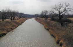
Moreau River
Encyclopedia
Missouri River
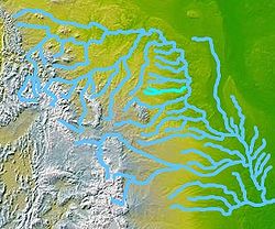
The Missouri River flows through the central United States, and is a tributary of the Mississippi River. It is the longest river in North America and drains the third largest area, though only the thirteenth largest by discharge. The Missouri's watershed encompasses most of the American Great...
, approximately 200 mi (320 km) long, in South Dakota
South Dakota
South Dakota is a state located in the Midwestern region of the United States. It is named after the Lakota and Dakota Sioux American Indian tribes. Once a part of Dakota Territory, South Dakota became a state on November 2, 1889. The state has an area of and an estimated population of just over...
in the United States
United States
The United States of America is a federal constitutional republic comprising fifty states and a federal district...
.
It rises in two forks in northwestern South Dakota, in the Badlands
Badlands
A badlands is a type of dry terrain where softer sedimentary rocks and clay-rich soils have been extensively eroded by wind and water. It can resemble malpaís, a terrain of volcanic rock. Canyons, ravines, gullies, hoodoos and other such geological forms are common in badlands. They are often...
of Harding County
Harding County, South Dakota
As of the census of 2000, there were 1,353 people, 525 households, and 352 families residing in the county. The population density was 0.5 people per square mile . There were 804 housing units at an average density of 0.3 per square mile...
. The North Fork rises approximately 10 mi (16 km) northeast of Crow Buttes. The South Fork rises approximately 20 mi (32 km) west of the headwaters of the North Fork. The two forks flow ESE and unite near Zeona in southern Perkins County
Perkins County, South Dakota
As of the census of 2000, there were 3,363 people, 1,429 households, and 937 families residing in the county. The population density was 1.2 people per square mile . There were 1,854 housing units at an average density of 0.6 per square mile...
. The combined stream flows east, past Usta, and across the Cheyenne River Indian Reservation
Cheyenne River Indian Reservation
The Cheyenne River Indian Reservation was created by the United States in 1889 by breaking up the Great Sioux Reservation, following its victory over the Lakota in a series of wars in the 1870s. The reservation covers almost all of Dewey and Ziebach counties in South Dakota...
, past Iron Lightning, Thunder Butte
Thunder Butte
Thunder Butte is a prominent butte landmark located in the northwest corner of Ziebach County, South Dakota, in the United States...
, Green Grass
Green Grass, South Dakota
Green Grass is a census-designated place in Dewey County, South Dakota, United States. The population was 35 at the 2010 census.-Geography:Green Grass is located at ....
and Whitehorse
Whitehorse, South Dakota
Whitehorse is a census-designated place in Dewey County, South Dakota, United States. The population was 141 at the 2010 census.-Geography:Whitehorse is located at ....
. It joins the Missouri in Lake Oahe
Lake Oahe
Lake Oahe is a large reservoir behind Oahe Dam on the Missouri River beginning in central South Dakota and continuing north into North Dakota in the United States. The lake has an area of and a maximum depth of . By volume, it is the fourth-largest reservoir in the US. Lake Oahe has a length of...
, with the lower 25 mi (40 km) of the river forming an arm of the reservoir.