

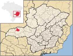
Monte Alegre de Minas
Encyclopedia
Minas Gerais
Minas Gerais is one of the 26 states of Brazil, of which it is the second most populous, the third richest, and the fourth largest in area. Minas Gerais is the Brazilian state with the largest number of Presidents of Brazil, the current one, Dilma Rousseff, being one of them. The capital is the...
. Its population as of 2007 was 18,348 living in a total area of 2,593 km². The city belongs to the statistical mesoregion
Mesoregion (Brazil)
Mesoregions are subdivisions of Brazilian states, grouping together various municipalities in proximity and with common characteristics. They were created by the Brazilian Institute of Geography and Statistics for statistical purposes and do not, therefore, constitute an administrative area....
of Triângulo Mineiro
Triângulo Mineiro
The Triangle Mineiro Portuguese pronunciation: [tɾiɐɡulu minejru] is an officer in the region west of the state of Minas Gerais, Brazil. The area is 93.500 km ² and is limited by the Serra da Canastra and Marcela, east, south of Sao Paulo, Goias in the north and west of the junction of the rivers...
and Alto Paranaíba and to the statistical microregion
Microregion (Brazil)
Microregions are legally defined administrative areas in Brazil consisting of groups of municipalities bordering urban areas. Microregions are grouped together into mesoregions....
of Uberlândia
Uberlândia
Uberlândia is the main town in the Triangle region, west of the state of Minas Gerais, Brazil. With a population of 604,013 inhabitants, according to 2010 estimates, the city is the second largest in the state second only to Belo Horizonte...
. It became a municipality in 1870.
Monte Alegre is located at an elevation of 730 meters in the rich region known as the Triângulo Mineiro
Triângulo Mineiro
The Triangle Mineiro Portuguese pronunciation: [tɾiɐɡulu minejru] is an officer in the region west of the state of Minas Gerais, Brazil. The area is 93.500 km ² and is limited by the Serra da Canastra and Marcela, east, south of Sao Paulo, Goias in the north and west of the junction of the rivers...
. It is east of Uberlândia
Uberlândia
Uberlândia is the main town in the Triangle region, west of the state of Minas Gerais, Brazil. With a population of 604,013 inhabitants, according to 2010 estimates, the city is the second largest in the state second only to Belo Horizonte...
and south of the great hydroelectric station and reservoir of Itumbiara. Federal highway BR-365, which links the state boundary of Goiás
Goiás
Goiás is a state of Brazil, located in the central part of the country. The name Goiás comes from the name of an indigenous community...
to Pirapora
Pirapora
Pirapora is a municipality in northcentral Minas Gerais in Brazil. Its population in 2007 was 51,636 in a total area of 577 km². The name Pirapora comes from the Tupi words for "fish" + "jump", referring to the piracema season when a mass migration of fishes ascends the São Francisco River...
in the north passes on the edge of the town.
The distance to Uberlândia
Uberlândia
Uberlândia is the main town in the Triangle region, west of the state of Minas Gerais, Brazil. With a population of 604,013 inhabitants, according to 2010 estimates, the city is the second largest in the state second only to Belo Horizonte...
is 68 km; the distance to Itumbiara
Itumbiara
Itumbiara is a small city and municipality in the extreme south of the state of Goiás, Brazil. The population was 100,000 in a total area of 2,461,3 km²...
is 80 km; and the distance to Belo Horizonte
Belo Horizonte
Belo Horizonte is the capital of and largest city in the state of Minas Gerais, located in the southeastern region of Brazil. It is the third largest metropolitan area in the country...
is 601 km. Neighboring municipalities are: Araporã
Araporã
Araporã is a Brazilian municipality located in the west of the state of Minas Gerais. Its population as of 2007 was 6,113 people living in a total area of 298 km². The city belongs to the statistical mesoregion of Triângulo Mineiro and Alto Paranaíba and to the microregion of Uberlândia...
and Tupaciguara
Tupaciguara
Tupaciguara is a Brazilian municipality located in the west of the state of Minas Gerais. Its population as of 2007 was 23,076 living in a total area of 1,826 km². The city belongs to the statistical mesoregion of Triângulo Mineiro and Alto Paranaíba and to the statistical microregion of...
(N); Centralina (W) ; Prata(S); Uberlândia
Uberlândia
Uberlândia is the main town in the Triangle region, west of the state of Minas Gerais, Brazil. With a population of 604,013 inhabitants, according to 2010 estimates, the city is the second largest in the state second only to Belo Horizonte...
(E)
The main economic activities are industry, services, and agriculture, especially the growing of pineapple and sugarcane. The GDP in 2005 was R$209,000.00, with 73,000.00 from services, 7,000.00 from industry, and 120,000.00 from agriculture. There were 1,486 rural producers on 205,000 hectares of land. 473 farms had tractors. The main crops were oranges, pineapple, bananas, sugarcane (8,500 hectares), soybeans (30,000 hectares), and corn. There were 132,000 head of cattle (2006) and over one million chickens.
The social indicators rank it in the top tier of municipalities in the state.
- Municipal Human Development IndexHuman Development IndexThe Human Development Index is a composite statistic used to rank countries by level of "human development" and separate "very high human development", "high human development", "medium human development", and "low human development" countries...
: 0.759 (2000) - State ranking: 215 out of 853 municipalities as of 2000
- National ranking: 1,608 out of 5,138 municipalities as of 2000
- Literacy rate: 87%
- Life expectancy: 70 (average of males and females)
The highest ranking municipality in Minas Gerais in 2000 was Poços de Caldas
Poços de Caldas
Poços de Caldas is a city and municipality in south-western Minas Gerais state, Brazil, in the microregion of the same name. Its estimated population in 2009 was 151,449 inhabitants...
with 0.841, while the lowest was Setubinha
Setubinha
Setubinha is a municipality in the northeast of the Brazilian state of Minas Gerais. As of 2007 the population was 10,834 in a total area of 536 km². The elevation is 729 metres. It is part of the IBGE statistical microregion of Teófilo Otoni...
with 0.568. Nationally the highest was São Caetano do Sul
São Caetano do Sul
São Caetano do Sul is a city in São Paulo state in Brazil, located in the Greater São Paulo Metropolitan Area. It is the city with the highest per capita income in Brazil and it also has the highest Human Development Index .-Geography:São Caetano do Sul is located on a plateau that is part of the...
in São Paulo with 0.919, while the lowest was Setubinha. In more recent statistics (considering 5,507 municipalities) Manari in the state of Pernambuco
Pernambuco
Pernambuco is a state of Brazil, located in the Northeast region of the country. To the north are the states of Paraíba and Ceará, to the west is Piauí, to the south are Alagoas and Bahia, and to the east is the Atlantic Ocean. There are about of beaches, some of the most beautiful in the...
has the lowest rating in the country--0,467--putting it in last place.