

Monson, Maine
Encyclopedia
Monson is a town
in Piscataquis County
, Maine
, United States
. As of the 2000 census, the town had a population of 666. The town is located on Route 15
which is a somewhat major route north to the well known Moosehead Lake Region, to which Monson is sometimes considered a gateway. This route ultimately leads to the Canadian Province of Quebec
.
The town is well known in local and state history, but is minimally known elsewhere, although contributions by the town, and its location are notable. It is the last town located on the Appalachian Trail
at the beginning (or end) of the 100-Mile Wilderness
. It is not uncommon to see many hikers in town resting before (or after) their trip into the Wilderness, and several lodging places in town cater directly to these hikers.
Monson was founded on February 8, 1822 by an act of the state legislature. It was named after Monson, Massachusetts
. Previously the town was part of a piece of land granted to both Hebron Academy
and Monson Academy by the state of Massachusetts in 1811. On April 22, 1822, the town had its first town meeting
to form a government. However the first resident first came here in 1816 after being here the previous fall to clear trees out for a settlement. Monson is also referenced in the book The Maine Woods by Henry David Thoreau
wherein a drawing of moose antlers depicting the direction and names of both Blanchard
and Monson, and the town is mentioned in other sections of the book. The antlers have been stolen and replaced several times, but currently they exist in the approximate location on a pole after leaving the town of Abbot
.
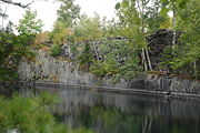
In 1870, slate
was discovered by a resident who had immigrated from Wales, while driving his horse in the countryside of the town. Over the next few decades many slate quarries were created increasing the population of the town, as well as generating a source of income for residents. Large-scale slate operations required construction of the Monson Railroad
in 1883; and two foot gauge locomotives transported slate and passengers to the larger Bangor and Aroostook Railroad
in Abbot until 1943. The slating industry began to decline after World War I
and most of the operations effectively ended. Currently, Sheldon Slate Company is the only operation that exists in the town, although there is a smaller operation selling typically roofing and landscaping slate. The slate from Monson makes up the Kennedy headstones in Washington D.C.
In 1945, after a fire at Greenville
's Moosehead Woodcrafters resulted in the company buying a former slate company's buildings that created a Moosehead Manufacturing, which produced furniture products for over 60 years until its recent closure in 2007. The company had a sister plant located in Dover-Foxcroft, and a store in North Carolina
, and shipped its products all over the state, country, and even as far away as Japan and other countries. The operation created many jobs for several generations, and it was not uncommon that fathers and sons, as well as mothers and daughters would work together. The town was greatly impacted by the revenue and income generated by the company, and had as many as 250 workers who lived either in town or in several communities around the town.
Throughout its history, Monson has been greatly surpassed by its neighbors to the north by means of tourism. The town had a hotel, and even a steamboat that took people on trips on Lake Hebron in the late 19th century and early 20th century, but due to several causes, the hotel and many of the local businesses dealing with tourism in the early 20th century were diminished. Since the 1990s, Monson has increased again in tourism and, with the closure of Moosehead Manufacturing, many consider Monson (as well as much of Piscataquis County), to cater towards tourism. This is evidenced in the rise of antique shops, a new pub and lodging, and several similar businesses increasing on Main Street.
are essentially graduates from Monson Academy, however no degree or ceremony is given for these graduates. There is also a small but remaining Monson Academy Alumni, that consists of mostly people born between 1920 and 1950. The Academy also had won state basketball tournaments in the 1950s and 1960s and many of the trophies, and other memorabilia from the school are held within the Monson Museum, and can be viewed. The school team was known as the Slaters and their colors were orange and black.
Currently, Monson Elementary and the gymnasium which is used for local and private events are still located on the site of the original school buildings as well as a recently restored band stand. Monson Elementary began operations in the 1980s and extension was created in the 1990s that created room for a new library and school rooms. The school only enrolls about 40 pupils, and only holds grades K through 4 as well as a pre-school. The elementary school is currently part of MSAD 68
. Residents of the town due to a ruling by the MSAD 68 Board of Directors decided to close Monson Elementary after the 2008-2009 school year. An effort however has begun to reorganize the school's partnerships with either Union 60 in Greenville or MSAD 4 in Guilford.
, the town has a total area of 49.2 square miles (127.4 km²), of which, 47.1 square miles (122 km²) of it is land and 2.2 square miles (5.7 km²) of it (4.41%) is water.
of 2000, there were 666 people, 295 households, and 179 families residing in the town. The population density
was 14.1 people per square mile (5.5/km²). There were 564 housing units at an average density of 12.0 per square mile (4.6/km²). The racial makeup of the town was 98.20% White, 0.30% Native American, 0.30% from other races
, and 1.20% from two or more races. Hispanic or Latino of any race were 0.45% of the population.
There were 293 households out of which 26.4% had children under the age of 18 living with them, 49.5% were married couples
living together, 7.5% had a female householder with no husband present, and 39.3% were non-families. 34.6% of all households were made up of individuals and 13.9% had someone living alone who was 65 years of age or older. The average household size was 2.25 and the average family size was 2.91.
In the town the population was spread out with 23.4% under the age of 18, 4.4% from 18 to 24, 26.4% from 25 to 44, 28.2% from 45 to 64, and 17.6% who were 65 years of age or older. The median age was 42 years. For every 100 females there were 103.0 males. For every 100 females age 18 and over, there were 102.4 males.
The median income for a household in the town was $26,964, and the median income for a family was $34,271. Males had a median income of $26,667 versus $20,962 for females. The per capita income
for the town was $14,044. About 9.8% of families and 15.7% of the population were below the poverty line, including 12.4% of those under age 18 and 50.8% of those age 65 or over.
New England town
The New England town is the basic unit of local government in each of the six New England states. Without a direct counterpart in most other U.S. states, New England towns are conceptually similar to civil townships in other states, but are incorporated, possessing powers like cities in other...
in Piscataquis County
Piscataquis County, Maine
Piscataquis County is a county located in the U.S. state of Maine. In 2010, its population was 17,535, making it Maine's least-populous county. Its county seat is Dover-Foxcroft....
, Maine
Maine
Maine is a state in the New England region of the northeastern United States, bordered by the Atlantic Ocean to the east and south, New Hampshire to the west, and the Canadian provinces of Quebec to the northwest and New Brunswick to the northeast. Maine is both the northernmost and easternmost...
, United States
United States
The United States of America is a federal constitutional republic comprising fifty states and a federal district...
. As of the 2000 census, the town had a population of 666. The town is located on Route 15
Maine State Route 15
State Route 15 is a numbered state highway in Maine, United States. Route 15 runs over from Stonington in the south to Jackman in the north.-Route description:...
which is a somewhat major route north to the well known Moosehead Lake Region, to which Monson is sometimes considered a gateway. This route ultimately leads to the Canadian Province of Quebec
Quebec
Quebec or is a province in east-central Canada. It is the only Canadian province with a predominantly French-speaking population and the only one whose sole official language is French at the provincial level....
.
The town is well known in local and state history, but is minimally known elsewhere, although contributions by the town, and its location are notable. It is the last town located on the Appalachian Trail
Appalachian Trail
The Appalachian National Scenic Trail, generally known as the Appalachian Trail or simply the AT, is a marked hiking trail in the eastern United States extending between Springer Mountain in Georgia and Mount Katahdin in Maine. It is approximately long...
at the beginning (or end) of the 100-Mile Wilderness
100-Mile Wilderness
The Hundred-Mile Wilderness is the section of the Appalachian Trail running between Abol Bridge just south of Baxter State Park and Monson, Maine, USA. It is generally considered the wildest section of the Appalachian Trail. This section of the A.T. is crossed by several logging roads and is...
. It is not uncommon to see many hikers in town resting before (or after) their trip into the Wilderness, and several lodging places in town cater directly to these hikers.
History
Monson was founded on February 8, 1822 by an act of the state legislature. It was named after Monson, Massachusetts
Monson, Massachusetts
Monson is a town in Hampden County, Massachusetts, United States. The population was 8,560 at the 2010 census. It is part of the Springfield, Massachusetts Metropolitan Statistical Area.The village of Monson Center lies at the center of the town....
. Previously the town was part of a piece of land granted to both Hebron Academy
Hebron Academy
Hebron Academy, founded in 1804, is a small, independent, college preparatory boarding and day school for boys and girls in grades six through postgraduate.-History:...
and Monson Academy by the state of Massachusetts in 1811. On April 22, 1822, the town had its first town meeting
Town meeting
A town meeting is a form of direct democratic rule, used primarily in portions of the United States since the 17th century, in which most or all the members of a community come together to legislate policy and budgets for local government....
to form a government. However the first resident first came here in 1816 after being here the previous fall to clear trees out for a settlement. Monson is also referenced in the book The Maine Woods by Henry David Thoreau
Henry David Thoreau
Henry David Thoreau was an American author, poet, philosopher, abolitionist, naturalist, tax resister, development critic, surveyor, historian, and leading transcendentalist...
wherein a drawing of moose antlers depicting the direction and names of both Blanchard
Blanchard, Maine
Blanchard is an unorganized territory in Piscataquis County, Maine, United States. The population was 83 at the 2000 census.-Geography:...
and Monson, and the town is mentioned in other sections of the book. The antlers have been stolen and replaced several times, but currently they exist in the approximate location on a pole after leaving the town of Abbot
Abbot, Maine
Abbot is a town in Piscataquis County, Maine, United States. The population was 714 at the 2010 census. It was named for the treasurer of Bowdoin College, John Abbot.-Geography:...
.
In 1870, slate
Slate
Slate is a fine-grained, foliated, homogeneous metamorphic rock derived from an original shale-type sedimentary rock composed of clay or volcanic ash through low-grade regional metamorphism. The result is a foliated rock in which the foliation may not correspond to the original sedimentary layering...
was discovered by a resident who had immigrated from Wales, while driving his horse in the countryside of the town. Over the next few decades many slate quarries were created increasing the population of the town, as well as generating a source of income for residents. Large-scale slate operations required construction of the Monson Railroad
Monson Railroad
The Monson Railroad was a gauge narrow gauge railroad which operated between Monson Junction on the Bangor and Aroostook Railroad and Monson, Maine. The primary purpose of this railroad was to serve several slate mines and finishing houses in Monson...
in 1883; and two foot gauge locomotives transported slate and passengers to the larger Bangor and Aroostook Railroad
Bangor and Aroostook Railroad
The Bangor and Aroostook Railroad is a defunct United States railroad company, that brought rail service to Aroostook County, Maine. Brightly painted BAR box cars attracted national attention in the 1950s. First-generation diesel locomotives operated on BAR until they were museum pieces...
in Abbot until 1943. The slating industry began to decline after World War I
World War I
World War I , which was predominantly called the World War or the Great War from its occurrence until 1939, and the First World War or World War I thereafter, was a major war centred in Europe that began on 28 July 1914 and lasted until 11 November 1918...
and most of the operations effectively ended. Currently, Sheldon Slate Company is the only operation that exists in the town, although there is a smaller operation selling typically roofing and landscaping slate. The slate from Monson makes up the Kennedy headstones in Washington D.C.
In 1945, after a fire at Greenville
Greenville, Maine
Greenville is a town in Piscataquis County, Maine, United States. The population was 1,623 at the 2000 census. The town is centered around the lower end of Moosehead Lake, the largest body of fresh water in the state. Greenville is the historic gateway to the north country and a center for...
's Moosehead Woodcrafters resulted in the company buying a former slate company's buildings that created a Moosehead Manufacturing, which produced furniture products for over 60 years until its recent closure in 2007. The company had a sister plant located in Dover-Foxcroft, and a store in North Carolina
North Carolina
North Carolina is a state located in the southeastern United States. The state borders South Carolina and Georgia to the south, Tennessee to the west and Virginia to the north. North Carolina contains 100 counties. Its capital is Raleigh, and its largest city is Charlotte...
, and shipped its products all over the state, country, and even as far away as Japan and other countries. The operation created many jobs for several generations, and it was not uncommon that fathers and sons, as well as mothers and daughters would work together. The town was greatly impacted by the revenue and income generated by the company, and had as many as 250 workers who lived either in town or in several communities around the town.
Throughout its history, Monson has been greatly surpassed by its neighbors to the north by means of tourism. The town had a hotel, and even a steamboat that took people on trips on Lake Hebron in the late 19th century and early 20th century, but due to several causes, the hotel and many of the local businesses dealing with tourism in the early 20th century were diminished. Since the 1990s, Monson has increased again in tourism and, with the closure of Moosehead Manufacturing, many consider Monson (as well as much of Piscataquis County), to cater towards tourism. This is evidenced in the rise of antique shops, a new pub and lodging, and several similar businesses increasing on Main Street.
Schools
Monson had a primary and secondary school known as Monson Academy. Although the school had begun classes in 1847, a longer lasting building did not succeed (due to fires) until 1861. The school remained in session till 1968 when the buildings were remodeled and 7th through 12th grades began to be bussed to Dover-Foxcroft. Graduates from Foxcroft AcademyFoxcroft Academy
Foxcroft Academy located in Dover-Foxcroft, Maine, was established as a private college preparatory school on January 30, 1823. According to its handbook, part of its historic mission as a private school is the education of secondary students from Maine communities who are without a high school...
are essentially graduates from Monson Academy, however no degree or ceremony is given for these graduates. There is also a small but remaining Monson Academy Alumni, that consists of mostly people born between 1920 and 1950. The Academy also had won state basketball tournaments in the 1950s and 1960s and many of the trophies, and other memorabilia from the school are held within the Monson Museum, and can be viewed. The school team was known as the Slaters and their colors were orange and black.
Currently, Monson Elementary and the gymnasium which is used for local and private events are still located on the site of the original school buildings as well as a recently restored band stand. Monson Elementary began operations in the 1980s and extension was created in the 1990s that created room for a new library and school rooms. The school only enrolls about 40 pupils, and only holds grades K through 4 as well as a pre-school. The elementary school is currently part of MSAD 68
Maine School Administrative District 68
Maine School Administrative District 68 consists of two public schools in Dover-Foxcroft, Maine. The district serves the towns of Dover-Foxcroft, Monson, Sebec, Charleston, and smaller communities. Students are often bussed in from these outlying towns. It is the largest of four school districts...
. Residents of the town due to a ruling by the MSAD 68 Board of Directors decided to close Monson Elementary after the 2008-2009 school year. An effort however has begun to reorganize the school's partnerships with either Union 60 in Greenville or MSAD 4 in Guilford.
Geography
According to the United States Census BureauUnited States Census Bureau
The United States Census Bureau is the government agency that is responsible for the United States Census. It also gathers other national demographic and economic data...
, the town has a total area of 49.2 square miles (127.4 km²), of which, 47.1 square miles (122 km²) of it is land and 2.2 square miles (5.7 km²) of it (4.41%) is water.
Demographics
As of the censusCensus
A census is the procedure of systematically acquiring and recording information about the members of a given population. It is a regularly occurring and official count of a particular population. The term is used mostly in connection with national population and housing censuses; other common...
of 2000, there were 666 people, 295 households, and 179 families residing in the town. The population density
Population density
Population density is a measurement of population per unit area or unit volume. It is frequently applied to living organisms, and particularly to humans...
was 14.1 people per square mile (5.5/km²). There were 564 housing units at an average density of 12.0 per square mile (4.6/km²). The racial makeup of the town was 98.20% White, 0.30% Native American, 0.30% from other races
Race (United States Census)
Race and ethnicity in the United States Census, as defined by the Federal Office of Management and Budget and the United States Census Bureau, are self-identification data items in which residents choose the race or races with which they most closely identify, and indicate whether or not they are...
, and 1.20% from two or more races. Hispanic or Latino of any race were 0.45% of the population.
There were 293 households out of which 26.4% had children under the age of 18 living with them, 49.5% were married couples
Marriage
Marriage is a social union or legal contract between people that creates kinship. It is an institution in which interpersonal relationships, usually intimate and sexual, are acknowledged in a variety of ways, depending on the culture or subculture in which it is found...
living together, 7.5% had a female householder with no husband present, and 39.3% were non-families. 34.6% of all households were made up of individuals and 13.9% had someone living alone who was 65 years of age or older. The average household size was 2.25 and the average family size was 2.91.
In the town the population was spread out with 23.4% under the age of 18, 4.4% from 18 to 24, 26.4% from 25 to 44, 28.2% from 45 to 64, and 17.6% who were 65 years of age or older. The median age was 42 years. For every 100 females there were 103.0 males. For every 100 females age 18 and over, there were 102.4 males.
The median income for a household in the town was $26,964, and the median income for a family was $34,271. Males had a median income of $26,667 versus $20,962 for females. The per capita income
Per capita income
Per capita income or income per person is a measure of mean income within an economic aggregate, such as a country or city. It is calculated by taking a measure of all sources of income in the aggregate and dividing it by the total population...
for the town was $14,044. About 9.8% of families and 15.7% of the population were below the poverty line, including 12.4% of those under age 18 and 50.8% of those age 65 or over.