

Mitchell micropolitan area
Encyclopedia
United States Census Bureau
The United States Census Bureau is the government agency that is responsible for the United States Census. It also gathers other national demographic and economic data...
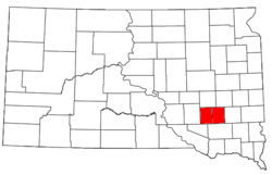
, is an area consisting of two counties in South Dakota
South Dakota
South Dakota is a state located in the Midwestern region of the United States. It is named after the Lakota and Dakota Sioux American Indian tribes. Once a part of Dakota Territory, South Dakota became a state on November 2, 1889. The state has an area of and an estimated population of just over...
, anchored by the city of Mitchell
Mitchell, South Dakota
-Demographics:As of the census of 2000, there were 14,558 people, 6,121 households, and 3,599 families residing in the city. The population density was 1,475.7 people per square mile . There were 6,555 housing units at an average density of 664.4 per square mile...
. As of the 2000 census
United States Census, 2000
The Twenty-second United States Census, known as Census 2000 and conducted by the Census Bureau, determined the resident population of the United States on April 1, 2000, to be 281,421,906, an increase of 13.2% over the 248,709,873 persons enumerated during the 1990 Census...
, the μSA had a population of 21,880 (though a July 1, 2009 estimate placed the population at 22,482).
Communities
- Cities
- AlexandriaAlexandria, South DakotaAlexandria is a city in Hanson County, South Dakota, United States. It is part of the Mitchell, South Dakota Micropolitan Statistical Area. The population was 615 at the 2010 census. It is the county seat of Hanson County.-History:...
- EmeryEmery, South DakotaEmery is a city in Hanson County, South Dakota, United States. It is part of the Mitchell, South Dakota Micropolitan Statistical Area. The population was 447 at the 2010 census.- School :Emery has a K-12 school...
- MitchellMitchell, South Dakota-Demographics:As of the census of 2000, there were 14,558 people, 6,121 households, and 3,599 families residing in the city. The population density was 1,475.7 people per square mile . There were 6,555 housing units at an average density of 664.4 per square mile...
(Principal city) - Mount VernonMount Vernon, South DakotaMount Vernon is a city in Davison County, South Dakota, United States. The population was 462 at the 2010 census. It is part of the Mitchell, South Dakota Micropolitan Statistical Area.-Geography:Mount Vernon is located at ....
- Alexandria
- Towns
- EthanEthan, South DakotaEthan is a town in Davison County, South Dakota, United States. It is part of the Mitchell, South Dakota Micropolitan Statistical Area. The population was 331 at the 2010 census...
- FarmerFarmer, South DakotaFarmer is a town in Hanson County, South Dakota, United States. It is part of the Mitchell, South Dakota Micropolitan Statistical Area. The population was 10 at the 2010 census.-Geography:Farmer is located at ....
- FultonFulton, South DakotaFulton is a town in Hanson County, South Dakota, United States. It is part of the Mitchell, South Dakota Micropolitan Statistical Area. The population was 91 at the 2010 census.-History:...
- Ethan
- Census-designated places
- LoomisLoomis, South DakotaLoomis is a census-designated place in Davison County, South Dakota, United States. The population was 34 at the 2010 census. It is part of the Mitchell, South Dakota Micropolitan Statistical Area.-Geography:...
- Loomis
- Unincorporated places
- Epiphany
Demographics
As of the censusCensus
A census is the procedure of systematically acquiring and recording information about the members of a given population. It is a regularly occurring and official count of a particular population. The term is used mostly in connection with national population and housing censuses; other common...
of 2000, there were 21,880 people, 8,700 households, and 5,618 families residing within the μSA. The racial makeup of the μSA was 96.70% White, 0.23% African American, 1.71% Native American, 0.38% Asian, 0.02% Pacific Islander, 0.26% from other races
Race (United States Census)
Race and ethnicity in the United States Census, as defined by the Federal Office of Management and Budget and the United States Census Bureau, are self-identification data items in which residents choose the race or races with which they most closely identify, and indicate whether or not they are...
, and 0.69% from two or more races. Hispanic or Latino of any race were 0.61% of the population.
The median income for a household in the μSA was $33,263, and the median income for a family was $41,929. Males had a median income of $28,969 versus $20,578 for females. The per capita income
Per capita income
Per capita income or income per person is a measure of mean income within an economic aggregate, such as a country or city. It is calculated by taking a measure of all sources of income in the aggregate and dividing it by the total population...
for the μSA was $16,329.