
Missouri Democratic primary, 2008
Encyclopedia
The Missouri
Democratic
Presidential Primary took place on Super Tuesday, February 5, 2008, with 72 delegates at stake. The winner in each of Missouri's nine congressional districts
was awarded all of that district's delegates, which totaled 47. Another 25 delegates were awarded to the statewide winner, Barack Obama
. The 72 delegates represented Missouri at the Democratic National Convention
in Denver, Colorado
. Sixteen other unpledged delegates, known as superdelegate
s, also attended the convention and cast their votes as well.
 Clinton had a large initial lead as the rural
precincts began reporting, leading several news groups to call the primary for her. However, Obama rallied from behind as the numbers began to come in from the heavily African American precincts in and around St. Louis
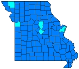
to win by just under 12,000 votes. The pledged delegates were evenly split between the two candidates. Geographically, Clinton won 109 of the 115 counties in the state, while Obama carried St. Louis
, Kansas City
and the areas around the college towns of Columbia
and Maryville
.
just barely nipped Hillary Rodham Clinton, who has roots in neighboring Arkansas
, by fewer than 12,000 votes. The popular vote was so close, however, that both candidates ended up evenly splitting the state’s 72 delegates. According to exit polls, 76 percent of voters in the Missouri Democratic Primary were Caucasians and they opted for Clinton by a margin of 57-39 compared to the 17 percent of African Americans who backed Obama by a margin of 84-15. Regarding age, Obama won younger voters under the age of 40 by a margin of 64-32; Clinton won voters ages 40–49 by a margin of 52-47 and tied Obama among voters 50-64, and she won senior citizens ages 65 and over by a margin of 63-32. Pertaining to socioeconomic class, Clinton won extremely poor voters making less than $15,000 a year by a margin of 52-45 while Obama won voters making $15,000-$30,000 by a margin of 55-42. Clinton won middle class
voters making $30,000-$50,000 by a margin of 49-48, while Obama won upper middle class and more affluent voters making over $50,000 by a margin of 54-43. As it relates to educational attainment, Clinton won less educated voters (those who did not graduate high school backed her by a margin of 55-42 compared to those who at least graduated high school who went for her 53-44) while Obama won more educated voters (those who had some college and/or an associate’s degree backed him 52-45; college graduates went for him 64-30, and those who had a postgraduate degree supported him 67-32). Self-identified Democrats, who made up 73 percent of the total turnout in the Democratic Primary, backed Clinton by a margin of 50-47 compared to the 22 percent of Independents
who supported Obama by a margin of 67-30 and self-identified Republicans
, who comprised 6 percent of the electorate, who supported Obama by a margin of 75-21. Obama won self-identified liberals
by a margin of 58-39 and self-identified conservatives
by a margin of 58-38 while Clinton won moderates by a margin of 49-48. Regarding religion, Obama won almost all major denominations – other Christians backed him by a margin of 63-33; other religions supported him by a margin of 61-36; and atheists
/agnostics
went for him by a margin of 51-46. Ironically, Roman Catholics
in Missouri also supported Obama by a margin of 50-46; this religious bloc solidly favored Clinton nationwide. Conversely, Clinton won Protestants
by a margin of 55-43, again ironic seeing as how most Protestants favored Obama nationwide.
Obama did best in and around St. Louis
, particularly in the urbanized
city with a substantial African American community which gave him 71.09 percent of the vote. He also performed extremely well in St. Louis County
, taking in 62.78 percent of the vote in the most affluent county in Missouri which contains many of the St. Louis Suburbs. Obama also won Jackson County
, which contains Kansas City
, with 55.42 percent of the vote; Obama carried Kansas City but lost the rest of Jackson County. Obama also performed strongly in Boone County
, which contains Columbia
and is home to the University of Missouri-Mizzou
, the flagship of the Missouri public university system. He also won neighboring Cole County, which contains Jefferson City
, as well as Nodaway County
in Northwestern Missouri which contains Northwestern Missouri State University in Maryville
.
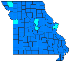
Clinton performed extremely well geographically all throughout the rest of the state, especially in the more rural parts of the state outside of Kansas City and St. Louis. She won the Kansas City Suburbs, including St. Joseph in Buchanan County
and some of the St. Louis Exurbs, including St. Charles County. Her best performance in the state was in Southeast Missouri where eight counties gave her over 70 percent of the vote. This area of the state, most of which is a part of the 8th District in the U.S. Congress, is heavily Democratic at the local level as Democrats control all county offices in all but four of the 28 counties in the congressional district. It is also fairly Democratic-leaning at the state level, going handily to Governor Jay Nixon
in the Missouri Gubernatorial Election of 2008, and while Southeast Missouri was won by Republicans George W. Bush
and John McCain
from 2000–2008, the region gave Bill Clinton
one of his largest margins of victory in 1992 and 1996. The area has many of the demographics in Clinton’s favor – it is predominantly white and made up of working-class individuals who tend to be politically moderate on several issues. She also performed well in Southwest Missouri, the most conservative part of the state, in and around Springfield
and Joplin
. Northern Missouri also strongly backed Clinton.
of the 1st District, who is African American, as well as U.S. Representative Russ Carnahan
of the 3rd District, endorsed Barack Obama. Both of their districts, which take in most and parts of St. Louis, were won by Obama in the Missouri Democratic Primary. U.S. Representative Emanuel Cleaver
of the 5th District, who is African American, as well as U.S. Representative Ike Skelton
of the 4th District, endorsed Hillary Rodham Clinton. Cleaver’s district went for Obama while Skelton’s district was handily won by Clinton.
U.S. Senator Claire McCaskill
came out as an early endorser of Barack Obama as well, citing pressure from her younger daughter as the main reason why she decided to endorse him.
Missouri
Missouri is a US state located in the Midwestern United States, bordered by Iowa, Illinois, Kentucky, Tennessee, Arkansas, Oklahoma, Kansas and Nebraska. With a 2010 population of 5,988,927, Missouri is the 18th most populous state in the nation and the fifth most populous in the Midwest. It...
Democratic
Democratic Party (United States)
The Democratic Party is one of two major contemporary political parties in the United States, along with the Republican Party. The party's socially liberal and progressive platform is largely considered center-left in the U.S. political spectrum. The party has the lengthiest record of continuous...
Presidential Primary took place on Super Tuesday, February 5, 2008, with 72 delegates at stake. The winner in each of Missouri's nine congressional districts
Missouri's Congressional Districts
Missouri used to have as many as sixteen congressional districts. Currently, it has nine.As a result of the 2010 Census it will lose a Congressional seat in 2013. Initial redistricting maps show the biggest impact being in the 3rd Congressional District...
was awarded all of that district's delegates, which totaled 47. Another 25 delegates were awarded to the statewide winner, Barack Obama
Barack Obama
Barack Hussein Obama II is the 44th and current President of the United States. He is the first African American to hold the office. Obama previously served as a United States Senator from Illinois, from January 2005 until he resigned following his victory in the 2008 presidential election.Born in...
. The 72 delegates represented Missouri at the Democratic National Convention
2008 Democratic National Convention
The United States 2008 Democratic National Convention was a quadrennial presidential nominating convention of the Democratic Party where it adopted its national platform and officially nominated its candidates for President and Vice President of the United States. The convention was held in Denver,...
in Denver, Colorado
Denver, Colorado
The City and County of Denver is the capital and the most populous city of the U.S. state of Colorado. Denver is a consolidated city-county, located in the South Platte River Valley on the western edge of the High Plains just east of the Front Range of the Rocky Mountains...
. Sixteen other unpledged delegates, known as superdelegate
Superdelegate
"Superdelegate" is an informal term commonly used for some of the delegates to the Democratic National Convention, the presidential nominating convention of the United States Democratic Party....
s, also attended the convention and cast their votes as well.
Polls
Results
Rural
Rural areas or the country or countryside are areas that are not urbanized, though when large areas are described, country towns and smaller cities will be included. They have a low population density, and typically much of the land is devoted to agriculture...
precincts began reporting, leading several news groups to call the primary for her. However, Obama rallied from behind as the numbers began to come in from the heavily African American precincts in and around St. Louis
St. Louis, Missouri
St. Louis is an independent city on the eastern border of Missouri, United States. With a population of 319,294, it was the 58th-largest U.S. city at the 2010 U.S. Census. The Greater St...
to win by just under 12,000 votes. The pledged delegates were evenly split between the two candidates. Geographically, Clinton won 109 of the 115 counties in the state, while Obama carried St. Louis
St. Louis, Missouri
St. Louis is an independent city on the eastern border of Missouri, United States. With a population of 319,294, it was the 58th-largest U.S. city at the 2010 U.S. Census. The Greater St...
, Kansas City
Kansas City, Missouri
Kansas City, Missouri is the largest city in the U.S. state of Missouri and is the anchor city of the Kansas City Metropolitan Area, the second largest metropolitan area in Missouri. It encompasses in parts of Jackson, Clay, Cass, and Platte counties...
and the areas around the college towns of Columbia
Columbia, Missouri
Columbia is the fifth-largest city in Missouri, and the largest city in Mid-Missouri. With a population of 108,500 as of the 2010 Census, it is the principal municipality of the Columbia Metropolitan Area, a region of 164,283 residents. The city serves as the county seat of Boone County and as the...
and Maryville
Maryville, Missouri
Maryville is a city in Nodaway County, Missouri, United States. The population was 10,581 at the 2000 census. The town, organized on February 14, 1845, was named for Mrs. Mary Graham, wife of Amos Graham, then the county clerk. Mary was the first Caucasian woman to have lived within the boundaries...
.
| Missouri Democratic Presidential Primary Results – 2008 | ||||||
|---|---|---|---|---|---|---|
| Party | Candidate | Votes | Percentage | Delegates | ||
| Democratic Democratic Party (United States) The Democratic Party is one of two major contemporary political parties in the United States, along with the Republican Party. The party's socially liberal and progressive platform is largely considered center-left in the U.S. political spectrum. The party has the lengthiest record of continuous... |
Barack Obama Barack Obama Barack Hussein Obama II is the 44th and current President of the United States. He is the first African American to hold the office. Obama previously served as a United States Senator from Illinois, from January 2005 until he resigned following his victory in the 2008 presidential election.Born in... |
406,917 | 49.32% | 36 | ||
| Democratic Democratic Party (United States) The Democratic Party is one of two major contemporary political parties in the United States, along with the Republican Party. The party's socially liberal and progressive platform is largely considered center-left in the U.S. political spectrum. The party has the lengthiest record of continuous... |
Hillary Rodham Clinton Hillary Rodham Clinton Hillary Diane Rodham Clinton is the 67th United States Secretary of State, serving in the administration of President Barack Obama. She was a United States Senator for New York from 2001 to 2009. As the wife of the 42nd President of the United States, Bill Clinton, she was the First Lady of the... |
395,185 | 47.90% | 36 | ||
| Democratic Democratic Party (United States) The Democratic Party is one of two major contemporary political parties in the United States, along with the Republican Party. The party's socially liberal and progressive platform is largely considered center-left in the U.S. political spectrum. The party has the lengthiest record of continuous... |
John Edwards John Edwards Johnny Reid "John" Edwards is an American politician, who served as a U.S. Senator from North Carolina. He was the Democratic nominee for Vice President in 2004, and was a candidate for the Democratic presidential nomination in 2004 and 2008.He defeated incumbent Republican Lauch Faircloth in... |
16,736 | 2.03% | 0 | ||
| Democratic Democratic Party (United States) The Democratic Party is one of two major contemporary political parties in the United States, along with the Republican Party. The party's socially liberal and progressive platform is largely considered center-left in the U.S. political spectrum. The party has the lengthiest record of continuous... |
Uncommitted | 3,142 | 0.38% | 0 | ||
| Democratic Democratic Party (United States) The Democratic Party is one of two major contemporary political parties in the United States, along with the Republican Party. The party's socially liberal and progressive platform is largely considered center-left in the U.S. political spectrum. The party has the lengthiest record of continuous... |
Dennis Kucinich Dennis Kucinich Dennis John Kucinich is the U.S. Representative for , serving since 1997. He was furthermore a candidate for the Democratic nomination for President of the United States in the 2004 and 2008 presidential elections.... |
820 | 0.10% | 0 | ||
| Democratic Democratic Party (United States) The Democratic Party is one of two major contemporary political parties in the United States, along with the Republican Party. The party's socially liberal and progressive platform is largely considered center-left in the U.S. political spectrum. The party has the lengthiest record of continuous... |
Bill Richardson | 689 | 0.08% | 0 | ||
| Democratic Democratic Party (United States) The Democratic Party is one of two major contemporary political parties in the United States, along with the Republican Party. The party's socially liberal and progressive platform is largely considered center-left in the U.S. political spectrum. The party has the lengthiest record of continuous... |
Joe Biden Joe Biden Joseph Robinette "Joe" Biden, Jr. is the 47th and current Vice President of the United States, serving under President Barack Obama... |
629 | 0.08% | 0 | ||
| Democratic Democratic Party (United States) The Democratic Party is one of two major contemporary political parties in the United States, along with the Republican Party. The party's socially liberal and progressive platform is largely considered center-left in the U.S. political spectrum. The party has the lengthiest record of continuous... |
Mike Gravel Mike Gravel Maurice Robert "Mike" Gravel is a former Democratic United States Senator from Alaska, who served two terms from 1969 to 1981, and a former candidate in the 2008 presidential election.... |
438 | 0.05% | 0 | ||
| Democratic Democratic Party (United States) The Democratic Party is one of two major contemporary political parties in the United States, along with the Republican Party. The party's socially liberal and progressive platform is largely considered center-left in the U.S. political spectrum. The party has the lengthiest record of continuous... |
Christopher Dodd Christopher Dodd Christopher John "Chris" Dodd is an American lawyer, lobbyist, and Democratic Party politician who served as a United States Senator from Connecticut for a thirty-year period ending with the 111th United States Congress.... |
250 | 0.03% | 0 | ||
| Democratic Democratic Party (United States) The Democratic Party is one of two major contemporary political parties in the United States, along with the Republican Party. The party's socially liberal and progressive platform is largely considered center-left in the U.S. political spectrum. The party has the lengthiest record of continuous... |
Ralph Spelbring | 220 | 0.03% | 0 | ||
| Totals | 827,107 | 100.00% | 72 | |||
| Voter turnout | % | — | ||||
Analysis
Elections in Missouri have historically always been rather close, and the Democratic Primary of 2008 proved no exception to that trend as Barack Obama of neighboring IllinoisIllinois
Illinois is the fifth-most populous state of the United States of America, and is often noted for being a microcosm of the entire country. With Chicago in the northeast, small industrial cities and great agricultural productivity in central and northern Illinois, and natural resources like coal,...
just barely nipped Hillary Rodham Clinton, who has roots in neighboring Arkansas
Arkansas
Arkansas is a state located in the southern region of the United States. Its name is an Algonquian name of the Quapaw Indians. Arkansas shares borders with six states , and its eastern border is largely defined by the Mississippi River...
, by fewer than 12,000 votes. The popular vote was so close, however, that both candidates ended up evenly splitting the state’s 72 delegates. According to exit polls, 76 percent of voters in the Missouri Democratic Primary were Caucasians and they opted for Clinton by a margin of 57-39 compared to the 17 percent of African Americans who backed Obama by a margin of 84-15. Regarding age, Obama won younger voters under the age of 40 by a margin of 64-32; Clinton won voters ages 40–49 by a margin of 52-47 and tied Obama among voters 50-64, and she won senior citizens ages 65 and over by a margin of 63-32. Pertaining to socioeconomic class, Clinton won extremely poor voters making less than $15,000 a year by a margin of 52-45 while Obama won voters making $15,000-$30,000 by a margin of 55-42. Clinton won middle class
Middle class
The middle class is any class of people in the middle of a societal hierarchy. In Weberian socio-economic terms, the middle class is the broad group of people in contemporary society who fall socio-economically between the working class and upper class....
voters making $30,000-$50,000 by a margin of 49-48, while Obama won upper middle class and more affluent voters making over $50,000 by a margin of 54-43. As it relates to educational attainment, Clinton won less educated voters (those who did not graduate high school backed her by a margin of 55-42 compared to those who at least graduated high school who went for her 53-44) while Obama won more educated voters (those who had some college and/or an associate’s degree backed him 52-45; college graduates went for him 64-30, and those who had a postgraduate degree supported him 67-32). Self-identified Democrats, who made up 73 percent of the total turnout in the Democratic Primary, backed Clinton by a margin of 50-47 compared to the 22 percent of Independents
Independent (politician)
In politics, an independent or non-party politician is an individual not affiliated to any political party. Independents may hold a centrist viewpoint between those of major political parties, a viewpoint more extreme than any major party, or they may have a viewpoint based on issues that they do...
who supported Obama by a margin of 67-30 and self-identified Republicans
Republican Party (United States)
The Republican Party is one of the two major contemporary political parties in the United States, along with the Democratic Party. Founded by anti-slavery expansion activists in 1854, it is often called the GOP . The party's platform generally reflects American conservatism in the U.S...
, who comprised 6 percent of the electorate, who supported Obama by a margin of 75-21. Obama won self-identified liberals
Liberalism
Liberalism is the belief in the importance of liberty and equal rights. Liberals espouse a wide array of views depending on their understanding of these principles, but generally, liberals support ideas such as constitutionalism, liberal democracy, free and fair elections, human rights,...
by a margin of 58-39 and self-identified conservatives
Conservatism
Conservatism is a political and social philosophy that promotes the maintenance of traditional institutions and supports, at the most, minimal and gradual change in society. Some conservatives seek to preserve things as they are, emphasizing stability and continuity, while others oppose modernism...
by a margin of 58-38 while Clinton won moderates by a margin of 49-48. Regarding religion, Obama won almost all major denominations – other Christians backed him by a margin of 63-33; other religions supported him by a margin of 61-36; and atheists
Atheism
Atheism is, in a broad sense, the rejection of belief in the existence of deities. In a narrower sense, atheism is specifically the position that there are no deities...
/agnostics
Agnosticism
Agnosticism is the view that the truth value of certain claims—especially claims about the existence or non-existence of any deity, but also other religious and metaphysical claims—is unknown or unknowable....
went for him by a margin of 51-46. Ironically, Roman Catholics
Roman Catholic Church
The Catholic Church, also known as the Roman Catholic Church, is the world's largest Christian church, with over a billion members. Led by the Pope, it defines its mission as spreading the gospel of Jesus Christ, administering the sacraments and exercising charity...
in Missouri also supported Obama by a margin of 50-46; this religious bloc solidly favored Clinton nationwide. Conversely, Clinton won Protestants
Protestantism
Protestantism is one of the three major groupings within Christianity. It is a movement that began in Germany in the early 16th century as a reaction against medieval Roman Catholic doctrines and practices, especially in regards to salvation, justification, and ecclesiology.The doctrines of the...
by a margin of 55-43, again ironic seeing as how most Protestants favored Obama nationwide.
Obama did best in and around St. Louis
St. Louis, Missouri
St. Louis is an independent city on the eastern border of Missouri, United States. With a population of 319,294, it was the 58th-largest U.S. city at the 2010 U.S. Census. The Greater St...
, particularly in the urbanized
Urban area
An urban area is characterized by higher population density and vast human features in comparison to areas surrounding it. Urban areas may be cities, towns or conurbations, but the term is not commonly extended to rural settlements such as villages and hamlets.Urban areas are created and further...
city with a substantial African American community which gave him 71.09 percent of the vote. He also performed extremely well in St. Louis County
St. Louis County, Missouri
St. Louis County is a county located in the U.S. state of Missouri. Its county seat is Clayton. St. Louis County is part of the St. Louis Metro Area wherein the independent City of St. Louis and its suburbs in St. Louis County, as well as the surrounding counties in both Missouri and Illinois all...
, taking in 62.78 percent of the vote in the most affluent county in Missouri which contains many of the St. Louis Suburbs. Obama also won Jackson County
Jackson County, Missouri
Jackson County is a county located in the U.S. state of Missouri. With a population of 674,158 in the 2010 census, Jackson County is the second most populous of Missouri's counties, after St. Louis County. Kansas City, the state's most populous city and focus city of the Kansas City Metropolitan...
, which contains Kansas City
Kansas City, Missouri
Kansas City, Missouri is the largest city in the U.S. state of Missouri and is the anchor city of the Kansas City Metropolitan Area, the second largest metropolitan area in Missouri. It encompasses in parts of Jackson, Clay, Cass, and Platte counties...
, with 55.42 percent of the vote; Obama carried Kansas City but lost the rest of Jackson County. Obama also performed strongly in Boone County
Boone County, Missouri
Boone County is a county centrally located in the U.S. state of Missouri. It is the eighth most populous county in Missouri. In 2010, the population was 162,642. Its county seat, Columbia, is the fifth largest city in Missouri and the anchor city of the Columbia Metropolitan Area.-History:Boone...
, which contains Columbia
Columbia, Missouri
Columbia is the fifth-largest city in Missouri, and the largest city in Mid-Missouri. With a population of 108,500 as of the 2010 Census, it is the principal municipality of the Columbia Metropolitan Area, a region of 164,283 residents. The city serves as the county seat of Boone County and as the...
and is home to the University of Missouri-Mizzou
University of Missouri
The University of Missouri System is a state university system providing centralized administration for four universities, a health care system, an extension program, five research and technology parks, and a publishing press. More than 64,000 students are currently enrolled at its four campuses...
, the flagship of the Missouri public university system. He also won neighboring Cole County, which contains Jefferson City
Jefferson City, Missouri
Jefferson City is the capital of the U.S. state of Missouri and the county seat of Cole County. Located in Callaway and Cole counties, it is the principal city of the Jefferson City metropolitan area, which encompasses the entirety of both counties. As of the 2010 census, the population was 43,079...
, as well as Nodaway County
Nodaway County, Missouri
Nodaway County is a county located in the U.S. state of Missouri. The county was organized in 1845 and named for the Nodaway River.As of 2010, the population was 23,370...
in Northwestern Missouri which contains Northwestern Missouri State University in Maryville
Maryville, Missouri
Maryville is a city in Nodaway County, Missouri, United States. The population was 10,581 at the 2000 census. The town, organized on February 14, 1845, was named for Mrs. Mary Graham, wife of Amos Graham, then the county clerk. Mary was the first Caucasian woman to have lived within the boundaries...
.
Clinton performed extremely well geographically all throughout the rest of the state, especially in the more rural parts of the state outside of Kansas City and St. Louis. She won the Kansas City Suburbs, including St. Joseph in Buchanan County
Buchanan County, Missouri
Buchanan County is a county located in the U.S. state of Missouri. As of 2010, the population was 89,201. Its county seat is Saint Joseph. When originally formed in 1838, the county was named Roberts County, after settler Hiram Roberts; it was renamed in 1839 for James Buchanan, then a U.S....
and some of the St. Louis Exurbs, including St. Charles County. Her best performance in the state was in Southeast Missouri where eight counties gave her over 70 percent of the vote. This area of the state, most of which is a part of the 8th District in the U.S. Congress, is heavily Democratic at the local level as Democrats control all county offices in all but four of the 28 counties in the congressional district. It is also fairly Democratic-leaning at the state level, going handily to Governor Jay Nixon
Jay Nixon
Jeremiah Wilson "Jay" Nixon, Sr. is the 55th and current Governor of the U.S. state of Missouri. A member of the Democratic Party, he previously served as Missouri's Attorney General before his election in 2008.-Political career:...
in the Missouri Gubernatorial Election of 2008, and while Southeast Missouri was won by Republicans George W. Bush
George W. Bush
George Walker Bush is an American politician who served as the 43rd President of the United States, from 2001 to 2009. Before that, he was the 46th Governor of Texas, having served from 1995 to 2000....
and John McCain
John McCain
John Sidney McCain III is the senior United States Senator from Arizona. He was the Republican nominee for president in the 2008 United States election....
from 2000–2008, the region gave Bill Clinton
Bill Clinton
William Jefferson "Bill" Clinton is an American politician who served as the 42nd President of the United States from 1993 to 2001. Inaugurated at age 46, he was the third-youngest president. He took office at the end of the Cold War, and was the first president of the baby boomer generation...
one of his largest margins of victory in 1992 and 1996. The area has many of the demographics in Clinton’s favor – it is predominantly white and made up of working-class individuals who tend to be politically moderate on several issues. She also performed well in Southwest Missouri, the most conservative part of the state, in and around Springfield
Springfield, Missouri
Springfield is the third largest city in the U.S. state of Missouri and the county seat of Greene County. According to the 2010 census data, the population was 159,498, an increase of 5.2% since the 2000 census. The Springfield Metropolitan Area, population 436,712, includes the counties of...
and Joplin
Joplin, Missouri
Joplin is a city in southern Jasper County and northern Newton County in the southwestern corner of the US state of Missouri. Joplin is the largest city in Jasper County, though it is not the county seat. As of the 2010 census, the city population was 50,150...
. Northern Missouri also strongly backed Clinton.
Endorsements
Democrats from Missouri’s congressional delegation were evenly split, a true testament to the outcome of the primary. U.S. Representative William Lacy Clay, Jr.William Lacy Clay, Jr.
William Lacy Clay, Jr., usually known as Lacy Clay is the U.S. Representative for , serving since 2001. He is a member of the Democratic Party....
of the 1st District, who is African American, as well as U.S. Representative Russ Carnahan
Russ Carnahan
John Russell "Russ" Carnahan is the U.S. Representative for , serving since 2005. He is a member of the Democratic Party.The district includes the southern third of the city of St. Louis and most of the southern St. Louis suburbs including most of Jefferson County and all of Ste. Genevieve County...
of the 3rd District, endorsed Barack Obama. Both of their districts, which take in most and parts of St. Louis, were won by Obama in the Missouri Democratic Primary. U.S. Representative Emanuel Cleaver
Emanuel Cleaver
Emanuel Cleaver II is a United Methodist pastor and the U.S. Representative for , serving since 2005. He is a member of the Democratic Party, and in January 2010 became chair of the Congressional Black Caucus....
of the 5th District, who is African American, as well as U.S. Representative Ike Skelton
Ike Skelton
Isaac Newton "Ike" Skelton IV is the former U.S. Representative for . During his tenure, he has served as the chairman of the House Armed Services Committee. He is a member for the Democratic Party...
of the 4th District, endorsed Hillary Rodham Clinton. Cleaver’s district went for Obama while Skelton’s district was handily won by Clinton.
U.S. Senator Claire McCaskill
Claire McCaskill
Claire Conner McCaskill is the senior United States Senator from Missouri and a member of the Democratic Party. She defeated Republican incumbent Jim Talent in the 2006 U.S. Senate election, by a margin of 49.6% to 47.3%. She is the first woman elected to the U.S. Senate from Missouri in her own...
came out as an early endorser of Barack Obama as well, citing pressure from her younger daughter as the main reason why she decided to endorse him.
County by County Results
- Hillary Rodham Clinton's strongest performance in Missouri was Dunklin CountyDunklin County, MissouriDunklin County is a county located in the Bootheel of Southeast Missouri in the United States. As of the 2000 U.S. Census, the county's population was 33,155. A 2008 estimate, however, showed the population to be 31,454. The largest city and county seat is Kennett...
, located in the BootheelBootheelThe Missouri Bootheel is the southeasternmost part of the state of Missouri, extending south of 36°30’ north latitude, so called because its shape in relation to the rest of the state resembles the heel of a boot. Strictly speaking, it is composed of the counties of Dunklin, New Madrid, and Pemiscot...
of Southeast Missouri. With its close proximity to ArkansasArkansasArkansas is a state located in the southern region of the United States. Its name is an Algonquian name of the Quapaw Indians. Arkansas shares borders with six states , and its eastern border is largely defined by the Mississippi River...
, Dunklin County backed Clinton with 78.44 percent of the vote while Barack Obama only received 18.31 percent. Dunklin County was also Obama's worst performance in Missouri. - Barack Obama's strongest performance in Missouri was St. Louis CitySt. Louis, MissouriSt. Louis is an independent city on the eastern border of Missouri, United States. With a population of 319,294, it was the 58th-largest U.S. city at the 2010 U.S. Census. The Greater St...
. Predominantly urbanUrban areaAn urban area is characterized by higher population density and vast human features in comparison to areas surrounding it. Urban areas may be cities, towns or conurbations, but the term is not commonly extended to rural settlements such as villages and hamlets.Urban areas are created and further...
with a substantial African American population, St. Louis City backed Obama with 71.09 percent of the vote while Hillary Rodham Clinton only received 27.25 percent. It was both Clinton and John Edwards's worst performance in Missouri. - Although he didn't carry it, Shelby County in Northeast Missouri was John Edwards's strongest performance in Missouri, as he received 7.57 percent of the vote here. Clinton, however, carried Shelby County with 54.37 percent of the vote.
- The closest county in Missouri was Howard County, located just west of Boone CountyBoone County, MissouriBoone County is a county centrally located in the U.S. state of Missouri. It is the eighth most populous county in Missouri. In 2010, the population was 162,642. Its county seat, Columbia, is the fifth largest city in Missouri and the anchor city of the Columbia Metropolitan Area.-History:Boone...
. Clinton won Howard County with 48.37 percent of the vote while Obama received 46.61 percent, a 1.77-percent difference.
| County | Hillary Rodham Clinton | Barack Obama Barack Obama Barack Hussein Obama II is the 44th and current President of the United States. He is the first African American to hold the office. Obama previously served as a United States Senator from Illinois, from January 2005 until he resigned following his victory in the 2008 presidential election.Born in... |
John Edwards John Edwards Johnny Reid "John" Edwards is an American politician, who served as a U.S. Senator from North Carolina. He was the Democratic nominee for Vice President in 2004, and was a candidate for the Democratic presidential nomination in 2004 and 2008.He defeated incumbent Republican Lauch Faircloth in... |
|---|---|---|---|
| Adair Adair County, Missouri Adair County is a county located in northeast Missouri. As of 2010, the population was 25,607. Its county seat is Kirksville. The county was organized in 1841 and is named in honor of Kentucky Governor John Adair.... |
49.50% | 46.88% | 2.74% |
| Andrew Andrew County, Missouri -External links:* from University of Missouri Division of Special Collections, Archives, and Rare Books... |
56.94% | 39.81% | 2.08% |
| Atchison Atchison County, Missouri Atchison County is a county located in the U.S. state of Missouri. As of 2010, the population was 5,685. Its county seat is Rock Port. The county was organized in 1845 and named for David Rice Atchison, U.S... |
54.73% | 41.32% | 2.37% |
| Audrain Audrain County, Missouri Audrain County is a county located in the U.S. state of Missouri. As of 2010, the population was 25,529. Its county seat is Mexico. The county was organized in 1836. Audrain County was named for Col. James Hunter Audrain. Col. Audrain was Colonel of militia in the War of 1812. In 1830 Col... |
57.42% | 39.34% | 2.52% |
| Barry Barry County, Missouri Barry County is a county located in the U.S. state of Missouri. As of 2010, the population was 35,597. Its county seat is Cassville. The county was organized in 1835 and named after William Taylor Barry from Kentucky, a United States Postmaster General.... |
65.52% | 30.47% | 3.08% |
| Barton | 63.43% | 32.85% | 3.00% |
| Bates Bates County, Missouri Bates County is a county located in the U.S. state of Missouri. As of 2000, the population is 16,653. Its county seat is Butler. The county was organized in 1833 and named after Frederick Bates, the second governor of Missouri.... |
63.51% | 30.08% | 4.72% |
| Benton | 68.77% | 26.95% | 3.14% |
| Bollinger Bollinger County, Missouri Bollinger County is a county located in Southeast Missouri in the United States. As of the 2010 U.S. Census, the county's population was 12,363; despite a 2009 estimate that showed the population to be 11,841. The county seat is Marble Hill, which is the only city in Bollinger County... |
74.12% | 22.37% | 2.90% |
| Boone Boone County, Missouri Boone County is a county centrally located in the U.S. state of Missouri. It is the eighth most populous county in Missouri. In 2010, the population was 162,642. Its county seat, Columbia, is the fifth largest city in Missouri and the anchor city of the Columbia Metropolitan Area.-History:Boone... |
36.92% | 60.57% | 1.52% |
| Buchanan Buchanan County, Missouri Buchanan County is a county located in the U.S. state of Missouri. As of 2010, the population was 89,201. Its county seat is Saint Joseph. When originally formed in 1838, the county was named Roberts County, after settler Hiram Roberts; it was renamed in 1839 for James Buchanan, then a U.S.... |
57.09% | 37.78% | 3.52% |
| Butler Butler County, Missouri Butler County is a county located in the southeast Ozark Foothills Region in Southeast Missouri in the United States. As of the 2010 U.S. Census, the county's population was 42,794. The largest city and county seat is Poplar Bluff. The county was officially organized from Wayne County on February... |
69.87% | 26.94% | 2.30% |
| Caldwell Caldwell County, Missouri Caldwell County is a county located in the U.S. state of Missouri. , the population was 8,969. Its county seat is Kingston. The county was organized in 1836 as a haven for the Mormons, who had been previously driven from Jackson County, Missouri in November of 1833 and had been refugees in... |
59.40% | 36.55% | 3.57% |
| Callaway Callaway County, Missouri Callaway County is a county located in the U.S. state of Missouri. It is part of the Jefferson City, Missouri Metropolitan Statistical Area. As of 2010, the population was 44,332. Its county seat is Fulton. The county was organized in 1820. It was named for Capt. James Callaway, a grandson of... |
54.71% | 41.26% | 3.10% |
| Camden Camden County, Missouri Camden County is a county located in the U.S. state of Missouri. As of 2000, the population was 37,051. Its county seat is Camdenton. The county was organized in 1841 as Kinderhook County and renamed in 1843, for Charles Pratt, 1st Earl Camden, Chancellor of England, and leader of the Whig... |
57.99% | 38.75% | 2.68% |
| Cape Girardeau Cape Girardeau County, Missouri Cape Girardeau County is a county located in Southeast Missouri in the United States. As of the 2010 U.S. Census, the county's population was 75,764. While the largest city in the county is Cape Girardeau, the county seat is actually Jackson, which was the first city named in honor of President... |
56.55% | 39.44% | 3.10% |
| Carroll | 62.84% | 34.29% | 2.41% |
| Carter Carter County, Missouri Carter County is a county located in the central western portion of the Ozark Foothills Region in Southeast Missouri in the United States. The county was officially organized on March 10, 1859, and is named after Zimri A. Carter, a pioneer settler who came to Missouri from South Carolina in 1812. ... |
75.24% | 19.05% | 4.45% |
| Cass Cass County, Missouri Cass County is a county located in the U.S. state of Missouri. As of 2010, the population was 99,478. Its county seat is Harrisonville. The county was organized in 1835 as "Van Buren County", renamed in 1848 after Michigan U.S... |
59.76% | 36.73% | 2.78% |
| Cedar Cedar County, Missouri Cedar County is a county located in the U.S. state of Missouri. As of 2000, the population was 13,733. Its county seat is Stockton.- Origin of name :... |
60.30% | 33.00% | 3.91% |
| Chariton Chariton County, Missouri Chariton County is a county located in the U.S. state of Missouri. As of 2000, the population was 8,438. Its county seat is Keytesville. The county was organized in 1820 from part of Howard County and was named from the Chariton River.-History:... |
61.60% | 31.50% | 5.02% |
| Christian Christian County, Missouri Christian County is a county located in Southwest Missouri. The county had a population of 54,285 in 2000 census. According to the 2010 census, the county's population is 77,422 , making it the fastest growing county in Missouri and one of the fastest growing in the nation as the county becomes... |
57.68% | 39.93% | 1.94% |
| Clark Clark County, Missouri Clark County is a county located in the U.S. state of Missouri. As of 2010, the population was 7,139. Its county seat is Kahoka. The county was organized in 1836 and named after William Clark, leader of the Lewis and Clark Expedition and later a Governor of Missouri Territory.Clark County is part... |
63.90% | 30.45% | 4.04% |
| Clay | 55.45% | 41.88% | 2.00% |
| Clinton Clinton County, Missouri As of the census of 2000, there were 18,979 people, 7,152 households, and 5,299 families residing in the county. The population density was 45 people per square mile . There were 7,877 housing units at an average density of 19 per square mile... |
57.07% | 37.57% | 3.83% |
| Cole | 45.07% | 51.16% | 2.91% |
| Cooper Cooper County, Missouri Cooper County is a county located in the U.S. state of Missouri. In 2010, the population was 17,601. Its county seat is Boonville. The county was organized in 1818 and is named for Sarshall Cooper, a frontier settler who was killed by Indians near Arrow Rock in 1814.-Geography:According to the 2000... |
54.96% | 42.18% | 2.27% |
| Crawford Crawford County, Missouri -State:In the Missouri House of Representatives, most of Crawford County is included within the 150th Legislative District and is currently represented by State Representative Jason T. Smith . In 2008, Smith defeated Democratic challenger James D. Ellis 69.97-30.03 percent; the Crawford County... |
66.36% | 30.07% | 2.61% |
| Dade | 62.22% | 33.12% | 3.53% |
| Dallas | 63.75% | 32.01% | 3.03% |
| Daviess | 62.75% | 33.25% | 2.70% |
| DeKalb DeKalb County, Missouri DeKalb County is a county located in the U.S. state of Missouri. As of 2010, the population is 12,892. The county was organized in 1845 and is named after the American Revolutionary War general Johann de Kalb. The county along with Buchanan and Andrew counties in Missouri and Doniphan County,... |
57.86% | 36.12% | 4.95% |
| Dent Dent County, Missouri Dent County is a county located in South Central Missouri in the United States. As of the 2000 U.S. Census, the county's population was 14,927. A 2008 estimate, however, showed the population to be 15,119. The largest city and county seat is Salem... |
62.23% | 31.89% | 4.79% |
| Douglas Douglas County, Missouri Douglas County is a county located in South Central Missouri in the United States. As of the 2010 U.S. Census, the county's population was 13,684. The largest city and county seat is Ava. The county was officially organized on October 29, 1857, and is named after U.S. Senator Stephen A... |
62.32% | 34.21% | 2.94% |
| Dunklin Dunklin County, Missouri Dunklin County is a county located in the Bootheel of Southeast Missouri in the United States. As of the 2000 U.S. Census, the county's population was 33,155. A 2008 estimate, however, showed the population to be 31,454. The largest city and county seat is Kennett... |
78.44% | 18.31% | 2.09% |
| Franklin Franklin County, Missouri Franklin County is a county located in the U.S. state of Missouri on the south side of the Missouri River. Franklin County is part of the St. Louis Metro Area and contains many of the St. Louis exurbs. Census 2010 put the population at 101,492; making it the 10th most populous county in Missouri.... |
55.83% | 40.28% | 2.96% |
| Gasconade Gasconade County, Missouri Gasconade County is a county in the U.S. state of Missouri located on the south side of the Missouri River, which once served as the chief route of transportation in the state. Located in the area called the Missouri Rhineland, the county had a population of 15,342 as of the 2000 U.S. Census. A... |
53.54% | 43.69% | 1.58% |
| Gentry Gentry County, Missouri As of the census of 2000, there were 6,861 people, 2,747 households, and 1,884 families residing in the county. The population density was 14 people per square mile . There were 3,214 housing units at an average density of 6 per square mile... |
53.32% | 40.68% | 4.95% |
| Greene Greene County, Missouri Greene County is a county located in Southwest Missouri. As of 2010, the population was 275,174 making it the fourth most populated county in Missouri. Its county seat is Springfield... |
54.94% | 42.77% | 1.84% |
| Grundy | 57.95% | 38.59% | 2.51% |
| Harrison Harrison County, Missouri As of the census of 2000, there were 8,850 people, 3,658 households, and 2,487 families residing in the county. The population density was 12 people per square mile . There were 4,316 housing units at an average density of 6 per square mile... |
60.81% | 34.73% | 3.35% |
| Henry Henry County, Missouri Henry County is a county located in the U.S. state of Missouri. As of 2000, the population was 21,997. Its county seat is Clinton. The county was organized in 1835 as Rives County, and renamed in 1841 after the American patriot Patrick Henry, of Virginia. The county was originally named after... |
63.18% | 32.10% | 3.67% |
| Hickory | 67.95% | 27.86% | 3.35% |
| Holt Holt County, Missouri Holt County is a county located in the U.S. state of Missouri. The county is in the northwest part of the state. As of 2010, the population was 4,912. Its county seat is Oregon. The county was organized in 1841 and is named after the Missouri state legislator Dr... |
57.99% | 37.91% | 3.28% |
| Howard | 48.38% | 46.61% | 3.53% |
| Howell Howell County, Missouri Howell County is a county located in South Central Missouri in the United States. As of the 2010 U.S. Census, the county's population was 40,400. The largest city and county seat is West Plains... |
64.07% | 32.44% | 2.75% |
| Iron Iron County, Missouri Iron County is a county located in the Lead Belt region in Southeast Missouri in the United States. As of the 2000 U.S. Census, the county's population was 10,697. A 2008 estimate, however, showed the population to be 9,918. The largest city and county seat is Ironton... |
70.53% | 24.27% | 4.30% |
| Jackson Jackson County, Missouri Jackson County is a county located in the U.S. state of Missouri. With a population of 674,158 in the 2010 census, Jackson County is the second most populous of Missouri's counties, after St. Louis County. Kansas City, the state's most populous city and focus city of the Kansas City Metropolitan... |
42.73% | 55.42% | 1.28% |
| Jasper Jasper County, Missouri Jasper County is a county located in the US state of Missouri. It is included in the Joplin, Missouri Metropolitan Statistical Area. The 2010 total population of Jasper County was 117,404. It is the ninth most populous county in Missouri. Its county seat is Carthage, making it one of the few... |
60.42% | 36.39% | 2.27% |
| Jefferson Jefferson County, Missouri Jefferson County is a county located in East Central Missouri in the United States. The county was included as the mean center of U.S. population in 1980. It is the sixth most-populous county in Missouri. Census 2010 put the population at 218,733 Its county seat is Hillsboro. The county was... |
61.32% | 35.02% | 2.74% |
| Johnson Johnson County, Missouri Johnson County is a county located in the U.S. state of Missouri. As of 2010, the population was 52,595. Its county seat is Warrensburg. The county was formed 13 December 1834 from Lafayette County and was named for Vice President Richard M... |
53.22% | 43.07% | 3.07% |
| Knox Knox County, Missouri As of the census of 2010, there are 4,131 people in the county, organized into 1,791 households and 1,217 families. The population density is 9 people per square mile . There are 2,317 housing units at an average density of 5 per square mile... |
61.73% | 30.86% | 5.76% |
| Laclede Laclede County, Missouri Laclede County is a county located in the U.S. state of Missouri. As of 2000, the population was 32,513. Its county seat is Lebanon. The county was organized February 24, 1849, and was named after Pierre Laclède, founder of St... |
62.48% | 33.77% | 2.69% |
| Lafayette | 60.75% | 35.40% | 2.61% |
| Lawrence | 61.58% | 34.86% | 2.81% |
| Lewis | 53.50% | 41.14% | 3.80% |
| Lincoln Lincoln County, Missouri As of the census of 2000, there were 38,944 people, 13,851 households, and 10,554 families residing in the county. The population density was 62 people per square mile . There were 15,511 housing units at an average density of 25 per square mile... |
61.35% | 34.51% | 3.34% |
| Linn Linn County, Missouri As of the census of 2000, there were 13,754 people, 5,697 households, and 3,760 families residing in the county. The population density was 22 people per square mile . There were 6,554 housing units at an average density of 11 per square mile... |
62.20% | 32.81% | 3.98% |
| Livingston | 59.85% | 34.72% | 4.29% |
| McDonald McDonald County, Missouri McDonald County is a county located in Southwest Missouri in the United States of America. As of the 2010 U.S. Census, the population was 23,083. Its county seat is Pineville... |
68.39% | 26.00% | 3.55% |
| Macon Macon County, Missouri Macon County is a county located in the U.S. state of Missouri. As of 2010, the population was 15,566. Its county seat is Macon. The county was organized in 1837 and named for Nathaniel Macon, a North Carolina politician... |
57.73% | 34.94% | 6.02% |
| Madison Madison County, Missouri Madison County is a county located in the Lead Belt region in Southeast Missouri in the United States. As of the 2000 U.S. Census, the county's population was 11,800. A 2008 estimate, however, showed the population to be 12,276. Its county seat and largest city is Fredericktown... |
68.72% | 24.35% | 4.53% |
| Maries | 66.09% | 28.66% | 3.76% |
| Marion | 54.44% | 40.75% | 3.60% |
| Mercer | 60.52% | 34.33% | 4.29% |
| Miller | 63.73% | 32.90% | 2.40% |
| Mississippi Mississippi County, Missouri Mississippi County is a county located in the Bootheel of Southeast Missouri in the United States. As of the 2000 U.S. Census, the county's population was 13,427. A 2008 estimate, however, showed the population to be 13,504. The largest city and county seat is Charleston... |
65.43% | 30.02% | 3.41% |
| Moniteau | 60.38% | 36.38% | 2.11% |
| Monroe | 52.73% | 39.68% | 6.08% |
| Montgomery Montgomery County, Missouri Montgomery County is a county located in the U.S. state of Missouri. It lies in East Central Missouri, approximately halfway between Columbia and St. Louis. As of 2000, the population was 12,136. It was named in honor of Richard Montgomery, an American Revolutionary War general killed in 1775... |
57.38% | 39.61% | 2.40% |
| Morgan Morgan County, Missouri Morgan County is a county located in the U.S. state of Missouri. As of July 2007, the population was 20,820. Its county seat is Versailles.-History :... |
62.05% | 33.58% | 3.38% |
| New Madrid New Madrid County, Missouri New Madrid County is a county located in the Bootheel of southeast Missouri in the United States. As of the 2000 Census, the county's population was 19,760. A 2008 estimate, however, showed the population to be 17,589. The largest city and county seat is New Madrid... |
71.19% | 24.11% | 3.99% |
| Newton | 65.55% | 31.46% | 2.26% |
| Nodaway Nodaway County, Missouri Nodaway County is a county located in the U.S. state of Missouri. The county was organized in 1845 and named for the Nodaway River.As of 2010, the population was 23,370... |
41.99% | 53.32% | 2.93% |
| Oregon Oregon County, Missouri Oregon County is a county located in South Central Missouri in the United States. As of the 2000 U.S. Census, the county's population was 10,344. A 2008 estimate, however, showed the population to be 10,264. Its county seat is Alton... |
71.77% | 24.09% | 3.05% |
| Osage Osage County, Missouri Osage County is a county located in the U.S. state of Missouri. The county was named for the Osage River. As of 2000, the population was 13,062. Its county seat is Linn. The center of population of Missouri is located in Osage County, in the city of Westphalia .Osage County is part of the... |
56.64% | 39.47% | 2.72% |
| Ozark Ozark County, Missouri Ozark County is a county located in South Central Missouri in the United States. As of the 2000 U.S. Census, the county's population was 9,542. A 2008 estimate, however, showed the population to be 9,227. The largest city and county seat is Gainesville. From 1843 to 1845 the county was called... |
65.62% | 31.62% | 1.71% |
| Pemiscot Pemiscot County, Missouri Pemiscot County is a county located in the Bootheel in Southeast Missouri in the United States. As of the 2000 U.S. Census, the county's population was 20,047. A 2008 estimate, however, showed the population to be 18,515. The largest city and county seat is Caruthersville... |
70.83% | 25.99% | 1.90% |
| Perry Perry County, Missouri Perry County is a county located in Southeast Missouri in the United States. As of the 2000 U.S. Census, the county's population was 18,132. In 2008 the population was estimated to be 18,743. Its county seat is Perryville. The county was officially organized on November 16, 1820 from Ste... |
61.24% | 33.73% | 4.20% |
| Pettis Pettis County, Missouri Pettis County is a county located in the U.S. state of Missouri. The county was organized in 1833 and is named for U.S. Congressman Spencer Darwin Pettis. As of 2000, the population was 39,403... |
54.76% | 41.38% | 3.00% |
| Phelps Phelps County, Missouri Phelps County is a county located in south-central Missouri in the United States.According to the U.S. Census Bureau, it includes the mean center of U.S. population in 2000. As of the 2000 U.S. Census, the county's population was 39,825. A 2008 estimate, however, showed the population to be 42,205.... |
53.93% | 42.34% | 2.75% |
| Pike Pike County, Missouri As of the census of 2010, there were 18,516 people, 6,451 households, and 4,476 families residing in the county. The population density was 27 people per square mile . There were 7,493 housing units at an average density of 11 per square mile... |
62.67% | 33.22% | 3.55% |
| Platte Platte County, Missouri As of the census of 2000, there were 73,781 people, 29,278 households, and 20,231 families residing in the county. The population density was 176 people per square mile . There were 30,902 housing units at an average density of 74 per square mile... |
50.07% | 47.53% | 1.77% |
| Polk Polk County, Missouri Polk County is a county located in the U.S. state of Missouri. As of 2010, the population was 31,137. Its county seat is Bolivar.Polk County is part of the Springfield, Missouri, Metropolitan Statistical Area.- History :... |
63.81% | 33.28% | 2.25% |
| Pulaski Pulaski County, Missouri Pulaski County is a county located in the U.S. state of Missouri. The county was organized in 1833 and named for Kazimierz Pułaski, Polish patriot who died fighting in the American Revolution. As of 2010, the population was 52,274, an increase of 27% from the 2000 Census count of 41,165. Its... |
56.07% | 39.35% | 3.16% |
| Putnam | 64.62% | 30.77% | 4.62% |
| Ralls | 57.84% | 35.42% | 5.48% |
| Randolph | 58.23% | 35.65% | 4.75% |
| Ray | 65.29% | 30.31% | 3.10% |
| Reynolds Reynolds County, Missouri Reynolds County is a county located in the northwestern portion of the Ozark Foothills Region in Southeast Missouri in the United States. As of the 2000 U.S. Census, the county's population was 6,689. A 2008 estimate, however, showed the population to be 6,388. Its county seat is Centerville... |
66.22% | 24.75% | 6.26% |
| Ripley Ripley County, Missouri Ripley County is a county located in the Ozarks of Southeast Missouri in the United States. As of the 2000 U.S. Census, the county's population was 13,509. A 2008 estimate, however, showed the population to be 13,485. The largest city and county seat is Doniphan... |
74.20% | 19.50% | 4.98% |
| Saline | 57.46% | 37.85% | 3.57% |
| Schuyler | 61.38% | 31.04% | 5.47% |
| Scotland | 54.03% | 36.41% | 7.38% |
| Scott Scott County, Missouri Scott County is a county located in Southeast Missouri in the United States. As of the 2000 U.S. Census, the population was 40,422; a 2008 estimate, however, showed the population to be 40,673. Its county seat is Benton... |
63.43% | 31.23% | 4.13% |
| Shannon Shannon County, Missouri Shannon County is a county located in South Central Missouri in the United States, and the second-largest by area in Missouri. As of the 2000 U.S. Census, the county's population was 8,324. A 2008 estimate, however, showed the population to be 8,423. Its county seat is Eminence. The county was... |
69.72% | 24.64% | 3.81% |
| Shelby | 54.37% | 35.34% | 7.57% |
| St. Charles | 50.14% | 47.48% | 1.74% |
| St. Clair | 67.52% | 26.12% | 4.54% |
| St. Francois | 70.25% | 25.84% | 2.90% |
| St. Louis County St. Louis County, Missouri St. Louis County is a county located in the U.S. state of Missouri. Its county seat is Clayton. St. Louis County is part of the St. Louis Metro Area wherein the independent City of St. Louis and its suburbs in St. Louis County, as well as the surrounding counties in both Missouri and Illinois all... |
35.50% | 62.78% | 1.26% |
| St. Louis City St. Louis, Missouri St. Louis is an independent city on the eastern border of Missouri, United States. With a population of 319,294, it was the 58th-largest U.S. city at the 2010 U.S. Census. The Greater St... |
27.25% | 71.09% | 0.94% |
| Ste. Genevieve | 62.36% | 34.07% | 2.76% |
| Stoddard Stoddard County, Missouri Stoddard County is a county located in Southeast Missouri in the United States. As of the 2000 U.S. Census, the population was 29,705. A 2008 estimate, however, showed the population to be 29,537. The county seat is Bloomfield while the largest city in the county is Dexter... |
72.95% | 22.43% | 3.67% |
| Stone Stone County, Missouri Stone County is a county located in Southwest Missouri in the United States. As of the 2010 U.S. Census, the county's population was 32,202. Its county seat is Galena... |
61.76% | 35.17% | 2.16% |
| Sullivan Sullivan County, Missouri Sullivan County is a county located in the U.S. state of Missouri. In 2010, the population was 6,714. Its county seat is Milan.-History:Sullivan County, Missouri encompasses of high glaciated prairie covered by steep rolling hills and numerous creeks and streams in north central Missouri... |
71.37% | 24.26% | 3.67% |
| Taney Taney County, Missouri Taney County is a county located in Southwest Missouri in the United States. As of the 2000 U.S. Census, the county's population was 39,703. In the 2010 census the counties population was 51,675 Its county seat is Forsyth.... |
63.69% | 33.74% | 1.89% |
| Texas Texas County, Missouri Texas County is a county located in South Central Missouri in the United States. As of the 2010 census, the county's population was 26,008. It's county seat is Houston. The county was organized in 1843 as Ashley County, changing its name in 1845 to Texas, after the Republic of Texas. The 2010 U.S... |
68.03% | 27.21% | 3.70% |
| Vernon | 61.55% | 31.42% | 5.32% |
| Warren Warren County, Missouri Warren County is a county located in the U.S. state of Missouri. Warren County is part of the St. Louis Metro Area and is located west of the city on the north side of the Missouri River. As of 2008, the population was estimated to be 31,214. Its county seat is Warrenton... |
56.46% | 40.07% | 2.64% |
| Washington Washington County, Missouri Washington County is a county located in East Central Missouri in the United States. As of the 2010 U.S. Census, the county's population was 25,195. The largest city and county seat is Potosi... |
74.63% | 21.32% | 3.18% |
| Wayne Wayne County, Missouri Wayne County is a county located in the Ozark Foothills Region of Southeast Missouri in the United States. As of the 2000 U.S. Census, the population was 13,259. A 2008 estimate, however, showed the population to be 12,652. The county seat is Greenville... |
75.94% | 18.70% | 3.70% |
| Webster Webster County, Missouri Webster County is a county located in Southwest Missouri. As of 2000, the population was 31,045. The population in 2010 was 36,202. Its county seat is Marshfield. The county was organized in 1855 and named for U.S. Senator and U.S... |
61.20% | 34.46% | 3.28% |
| Worth | 57.97% | 35.59% | 5.76% |
| Wright Wright County, Missouri Wright County is a county located in South Central Missouri in the United States. As of the 2010 U.S. Census, the county's population was 18,815. Its county seat is Hartville. The county was officially organized on January 29, 1841, and is named after Silas Wright , a former Congressman, U.S... |
69.48% | 27.48% | 2.19% |
See also
- Democratic Party (United States) presidential primaries, 2008Democratic Party (United States) presidential primaries, 2008The 2008 Democratic presidential primaries were the selection process by which voters of the Democratic Party chose its nominee for President of the United States in the 2008 U.S. presidential election...
- Missouri Republican primary, 2008Missouri Republican primary, 2008The 2008 Missouri Republican Presidential Primary on February 5, 2008 determined the recipient of 55 of the state's 58 delegates to the Republican National Convention in the process to elect the 44th President of the United States. It was an open primary...