

Mission Bend, Texas
Encyclopedia
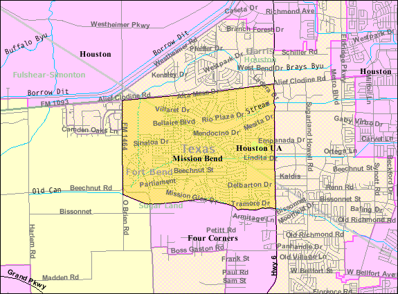
Mission Bend is a census-designated place
(CDP) around Texas State Highway 6 within the extraterritorial jurisdiction
of Houston
in Fort Bend
and Harris
Counties in the U.S. state
of Texas
; Mission Bend is four miles northwest of the city hall of Sugar Land
and twenty miles southwest of Downtown Houston
. The population was 30,831 at the 2000 census.
 Mission Bend is located at 29°41′37"N 95°39′42"W (29.693667, -95.661721).
According to the United States Census Bureau
, the CDP has a total area of 5.3 square miles (13.6 km²), of which, 5.2 square miles (13.5 km²) of it is land and 0.04 square miles (0.1 km²) of it (0.57%) is water.
of 2000, there were 30,831 people, 8,978 households, and 7,864 families residing in the CDP. The population density
was 5,900.1 people per square mile (2,276.1/km²). There were 9,202 housing units at an average density of 1,761.0/sq mi (679.3/km²). The racial makeup of the CDP was 46.32% White, 21.50% African American, 0.31% Native American, 16.96% Asian, 0.08% Pacific Islander, 10.63% from other races
, and 4.20% from two or more races. Hispanic or Latino of any race were 27.06% of the population.
There were 8,978 households out of which 55.7% had children under the age of 18 living with them, 70.5% were married couples
living together, 12.5% had a female householder with no husband present, and 12.4% were non-families. 9.5% of all households were made up of individuals and 1.1% had someone living alone who was 65 years of age or older. The average household size was 3.43 and the average family size was 3.67.
In the CDP the population was spread out with 33.7% under the age of 18, 8.1% from 18 to 24, 32.9% from 25 to 44, 21.4% from 45 to 64, and 3.9% who were 65 years of age or older. The median age was 32 years. For every 100 females there were 97.2 males. For every 100 females age 18 and over, there were 92.2 males.
The median income for a household in the CDP was $60,222, and the median income for a family was $60,999. Males had a median income of $39,323 versus $31,119 for females. The per capita income
for the CDP was $20,029. About 4.5% of families and 5.7% of the population were below the poverty line, including 7.5% of those under age 18 and 8.9% of those age 65 or over.
serves the Harris County side. It operates the Mission Bend Storefront in an unincorporated area
in the International District
adjacent to the CDP.
(METRO) operates public bus services in the area. The agency operates the Mission Bend Park and Ride in an unincorporated area
of Harris County, near Mission Bend.
. Mission Bend CDP residents in Harris County are zoned to schools in the Alief Independent School District
. The Fort Bend County section is within the West Division, controlling school board slots 1 through 3. As of 2008 the board members in the slots are Susan Hohnbaum, Sonal Buchar, and Bob Broxson, respectively.
Elementary schools serving the FBISD section of the Mission Bend CDP and within the Mission Bend CDP include Mission Bend, Mission Glen, and Mission West. Arizona Fleming, located in the Four Corners
CDP, serves a section of the Mission Bend CDP. Hodges Bend Middle School, located in the Four Corners CDP, serves almost all of the FBISD portion of the CDP, while Crockett Middle School, outside of the Mission Bend CDP, serves a small portion. George Bush High School
, located in the Mission Bend CDP, serves the FBISD section of the Mission Bend CDP.
Alief schools that serve Harris County areas in the Mission Bend CDP include Petrosky Elementary School (in the CDP), Miller Intermediate School (outside of the CDP), and Albright Middle School (inside the CDP). Elementary school bilingual students are zoned to Rees Elementary School. Alief ISD students are randomly assigned to either Elsik
, Hastings
, or Taylor
high schools. None of the high schools are within the Mission Bend CDP.
Census-designated place
A census-designated place is a concentration of population identified by the United States Census Bureau for statistical purposes. CDPs are delineated for each decennial census as the statistical counterparts of incorporated places such as cities, towns and villages...
(CDP) around Texas State Highway 6 within the extraterritorial jurisdiction
Extraterritorial jurisdiction
Extraterritorial jurisdiction is the legal ability of a government to exercise authority beyond its normal boundaries.Any authority can, of course, claim ETJ over any external territory they wish...
of Houston
Houston, Texas
Houston is the fourth-largest city in the United States, and the largest city in the state of Texas. According to the 2010 U.S. Census, the city had a population of 2.1 million people within an area of . Houston is the seat of Harris County and the economic center of , which is the ...
in Fort Bend
Fort Bend County, Texas
Fort Bend County is a county located along the Gulf Coast region in the U.S. state of Texas within the Houston–Sugar Land–Baytown metropolitan area. In 2000 its population was 354,452, while the 2010 U.S...
and Harris
Harris County, Texas
As of the 2010 Census, the population of the county was 4,092,459, White Americans made up 56.6% of Harris County's population; non-Hispanic whites represented 33.0% of the population. Black Americans made up 18.9% of the population. Native Americans made up 0.7% of Harris County's population...
Counties in the U.S. state
U.S. state
A U.S. state is any one of the 50 federated states of the United States of America that share sovereignty with the federal government. Because of this shared sovereignty, an American is a citizen both of the federal entity and of his or her state of domicile. Four states use the official title of...
of Texas
Texas
Texas is the second largest U.S. state by both area and population, and the largest state by area in the contiguous United States.The name, based on the Caddo word "Tejas" meaning "friends" or "allies", was applied by the Spanish to the Caddo themselves and to the region of their settlement in...
; Mission Bend is four miles northwest of the city hall of Sugar Land
Sugar Land, Texas
Sugar Land is a city in the U.S. state of Texas within the metropolitan area and Fort Bend County. Sugar Land is one of the most affluent and fastest-growing cities in Texas, having grown more than 158 percent in the last decade. In the time period of 2000–2007, Sugar Land also enjoyed a...
and twenty miles southwest of Downtown Houston
Downtown Houston
Downtown Houston is the largest business district of Houston, Texas, United States. Downtown Houston, the city's central business district, contains the headquarters of many prominent companies. There is an extensive network of pedestrian tunnels and skywalks connecting the buildings of the district...
. The population was 30,831 at the 2000 census.
History
Mission Bend began in the early 1980s. The area gained population between 1980 and 1990. In 1990 the community had 24,945 residents. By 2000 many of the area's residents commuted to Houston.Geography
According to the United States Census Bureau
United States Census Bureau
The United States Census Bureau is the government agency that is responsible for the United States Census. It also gathers other national demographic and economic data...
, the CDP has a total area of 5.3 square miles (13.6 km²), of which, 5.2 square miles (13.5 km²) of it is land and 0.04 square miles (0.1 km²) of it (0.57%) is water.
Demographics
As of the censusCensus
A census is the procedure of systematically acquiring and recording information about the members of a given population. It is a regularly occurring and official count of a particular population. The term is used mostly in connection with national population and housing censuses; other common...
of 2000, there were 30,831 people, 8,978 households, and 7,864 families residing in the CDP. The population density
Population density
Population density is a measurement of population per unit area or unit volume. It is frequently applied to living organisms, and particularly to humans...
was 5,900.1 people per square mile (2,276.1/km²). There were 9,202 housing units at an average density of 1,761.0/sq mi (679.3/km²). The racial makeup of the CDP was 46.32% White, 21.50% African American, 0.31% Native American, 16.96% Asian, 0.08% Pacific Islander, 10.63% from other races
Race (United States Census)
Race and ethnicity in the United States Census, as defined by the Federal Office of Management and Budget and the United States Census Bureau, are self-identification data items in which residents choose the race or races with which they most closely identify, and indicate whether or not they are...
, and 4.20% from two or more races. Hispanic or Latino of any race were 27.06% of the population.
There were 8,978 households out of which 55.7% had children under the age of 18 living with them, 70.5% were married couples
Marriage
Marriage is a social union or legal contract between people that creates kinship. It is an institution in which interpersonal relationships, usually intimate and sexual, are acknowledged in a variety of ways, depending on the culture or subculture in which it is found...
living together, 12.5% had a female householder with no husband present, and 12.4% were non-families. 9.5% of all households were made up of individuals and 1.1% had someone living alone who was 65 years of age or older. The average household size was 3.43 and the average family size was 3.67.
In the CDP the population was spread out with 33.7% under the age of 18, 8.1% from 18 to 24, 32.9% from 25 to 44, 21.4% from 45 to 64, and 3.9% who were 65 years of age or older. The median age was 32 years. For every 100 females there were 97.2 males. For every 100 females age 18 and over, there were 92.2 males.
The median income for a household in the CDP was $60,222, and the median income for a family was $60,999. Males had a median income of $39,323 versus $31,119 for females. The per capita income
Per capita income
Per capita income or income per person is a measure of mean income within an economic aggregate, such as a country or city. It is calculated by taking a measure of all sources of income in the aggregate and dividing it by the total population...
for the CDP was $20,029. About 4.5% of families and 5.7% of the population were below the poverty line, including 7.5% of those under age 18 and 8.9% of those age 65 or over.
Government and infrastructure
The Harris County Sheriff's OfficeHarris County Sheriff's Office
The Harris County Sheriff's Office is a local law enforcement agency serving the over three million citizens of Harris County, Texas, United States. It is headquartered in the 1200 Jail in Downtown Houston.As of the 2000 U.S...
serves the Harris County side. It operates the Mission Bend Storefront in an unincorporated area
Unincorporated area
In law, an unincorporated area is a region of land that is not a part of any municipality.To "incorporate" in this context means to form a municipal corporation, a city, town, or village with its own government. An unincorporated community is usually not subject to or taxed by a municipal government...
in the International District
International District (Greater Houston)
The International Management District is a management district in Harris County and Fort Bend County, Texas. Most of the district is within the city of Houston, while a portion lies within an unincorporated area.-History:...
adjacent to the CDP.
Transportation
Metropolitan Transit Authority of Harris County, TexasMetropolitan Transit Authority of Harris County, Texas
The Metropolitan Transit Authority of Harris County is a major public transportation agency based in Houston . It operates bus, light rail, future commuter rail, and paratransit service in the city as well as most of Harris County...
(METRO) operates public bus services in the area. The agency operates the Mission Bend Park and Ride in an unincorporated area
Unincorporated area
In law, an unincorporated area is a region of land that is not a part of any municipality.To "incorporate" in this context means to form a municipal corporation, a city, town, or village with its own government. An unincorporated community is usually not subject to or taxed by a municipal government...
of Harris County, near Mission Bend.
Public schools
Mission Bend CDP residents in Fort Bend County are zoned to schools in the Fort Bend Independent School DistrictFort Bend Independent School District
The Fort Bend Independent School District, also known as Fort Bend ISD or FBISD, is a school district system in the U.S. state of Texas based in the city of Sugar Land....
. Mission Bend CDP residents in Harris County are zoned to schools in the Alief Independent School District
Alief Independent School District
Alief Independent School District is a school district that is based in southwest Houston, Texas, United States.Alief ISD, which covers of land, covers a small portion of southwest Houston and parts of unincorporated Harris County...
. The Fort Bend County section is within the West Division, controlling school board slots 1 through 3. As of 2008 the board members in the slots are Susan Hohnbaum, Sonal Buchar, and Bob Broxson, respectively.
Elementary schools serving the FBISD section of the Mission Bend CDP and within the Mission Bend CDP include Mission Bend, Mission Glen, and Mission West. Arizona Fleming, located in the Four Corners
Four Corners, Texas
Four Corners is a census-designated place within the extraterritorial jurisdiction of Houston in Fort Bend County, Texas, United States. The population was 2,954 at the 2000 census.-History:Four Corners began as a community of extended families...
CDP, serves a section of the Mission Bend CDP. Hodges Bend Middle School, located in the Four Corners CDP, serves almost all of the FBISD portion of the CDP, while Crockett Middle School, outside of the Mission Bend CDP, serves a small portion. George Bush High School
George Bush High School
George Bush High School is a fully accredited public high school located in unincorporated Fort Bend County, Texas, serving students in grades 9-12. The school is a part of the Fort Bend Independent School District and serves several areas of unincorporated Fort Bend County, including Mission Bend...
, located in the Mission Bend CDP, serves the FBISD section of the Mission Bend CDP.
Alief schools that serve Harris County areas in the Mission Bend CDP include Petrosky Elementary School (in the CDP), Miller Intermediate School (outside of the CDP), and Albright Middle School (inside the CDP). Elementary school bilingual students are zoned to Rees Elementary School. Alief ISD students are randomly assigned to either Elsik
Alief Elsik High School
Alief Elsik High School is a secondary school located in the Alief region of Houston, Texas.Elsik is divided into two campuses: the main campus , and the Alief Elsik Ninth Grade Center , which serves ninth graders...
, Hastings
Alief Hastings High School
Alief Hastings High School is a secondary school in the Alief neighborhood of Houston, Texas, United States. Originally named Alief Junior-Senior High School, the school's present location opened in 1972....
, or Taylor
Alief Taylor High School
Alief Taylor High School is a public high school, located in Alief Independent School District in unincorporated Harris County, Texas. Opened in 2001, Alief Taylor is the newest high school in Alief ISD...
high schools. None of the high schools are within the Mission Bend CDP.