
Missinaibi River
Encyclopedia
Ontario
Ontario is a province of Canada, located in east-central Canada. It is Canada's most populous province and second largest in total area. It is home to the nation's most populous city, Toronto, and the nation's capital, Ottawa....
, Canada
Canada
Canada is a North American country consisting of ten provinces and three territories. Located in the northern part of the continent, it extends from the Atlantic Ocean in the east to the Pacific Ocean in the west, and northward into the Arctic Ocean...
, which flows northeast from Missinaibi Lake
Missinaibi Lake
Missinaibi Lake is a lake in Ontario, Canada, about north of Chapleau. It is the source of the Missinaibi River, which rises from the lake and flows northeastward into the Moose River....
, north of Chapleau
Chapleau, Ontario
Chapleau is a township in Sudbury District, Ontario, Canada. It is home to one of the world's largest wildlife preserves. Chapleau has a population of 2,354 according to the Canada 2006 Census....
, and empties into the Moose River
Moose River (Ontario)
The Moose River is a Canadian river in the Hudson Plains ecozone of northern Ontario which flows 100 km northeast from the junction of the Mattagami and Missinaibi Rivers into James Bay. Its drainage basin is 108,500 km² and it has a mean discharge rate of 1370 m³/s. Its full length...
, which drains into James Bay
James Bay
James Bay is a large body of water on the southern end of Hudson Bay in Canada. Both bodies of water extend from the Arctic Ocean. James Bay borders the provinces of Quebec and Ontario; islands within the bay are part of Nunavut...
. This river (including Missinaibi Lake and Moose River
Moose River (Ontario)
The Moose River is a Canadian river in the Hudson Plains ecozone of northern Ontario which flows 100 km northeast from the junction of the Mattagami and Missinaibi Rivers into James Bay. Its drainage basin is 108,500 km² and it has a mean discharge rate of 1370 m³/s. Its full length...
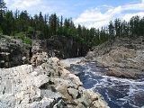
to James Bay) is 755 kilometres (469.1 mi) in length. It is one of the longest free-flowing and undeveloped rivers in Ontario.
The river's name means "pictured waters" in the Cree language
Cree language
Cree is an Algonquian language spoken by approximately 117,000 people across Canada, from the Northwest Territories and Alberta to Labrador, making it the aboriginal language with the highest number of speakers in Canada. It is also spoken in the U.S. state of Montana...
which is thought to refer to the pictographs
Pictogram
A pictograph, also called pictogram or pictogramme is an ideogram that conveys its meaning through its pictorial resemblance to a physical object. Pictographs are often used in writing and graphic systems in which the characters are to considerable extent pictorial in appearance.Pictography is a...
found on rock faces along the river.
At Thunderhouse Falls, which is actually a chain of relatively small waterfalls connected by violent rapids, the river drops 40 metres, part of its descent from the Canadian Shield
Canadian Shield
The Canadian Shield, also called the Laurentian Plateau, or Bouclier Canadien , is a vast geological shield covered by a thin layer of soil that forms the nucleus of the North American or Laurentia craton. It is an area mostly composed of igneous rock which relates to its long volcanic history...
to the Hudson Bay
Hudson Bay
Hudson Bay , sometimes called Hudson's Bay, is a large body of saltwater in northeastern Canada. It drains a very large area, about , that includes parts of Ontario, Quebec, Saskatchewan, Alberta, most of Manitoba, southeastern Nunavut, as well as parts of North Dakota, South Dakota, Minnesota,...
Lowlands.
History
In the days of the fur tradeNorth American Fur Trade
The North American fur trade was the industry and activities related to the acquisition, exchange, and sale of animal furs in the North American continent. Indigenous peoples of different regions traded among themselves in the Pre-Columbian Era, but Europeans participated in the trade beginning...
, this river provided access to James Bay
James Bay
James Bay is a large body of water on the southern end of Hudson Bay in Canada. Both bodies of water extend from the Arctic Ocean. James Bay borders the provinces of Quebec and Ontario; islands within the bay are part of Nunavut...
by way of the Moose River and to Lake Superior
Lake Superior
Lake Superior is the largest of the five traditionally-demarcated Great Lakes of North America. It is bounded to the north by the Canadian province of Ontario and the U.S. state of Minnesota, and to the south by the U.S. states of Wisconsin and Michigan. It is the largest freshwater lake in the...
by way of the Michipicoten River
Michipicoten River
The Michipicoten River is a river in the Algoma District of northern Ontario, Canada, which flows from Dog Lake and joins with the Magpie River to empty into Michipicoten Bay on Lake Superior near the town of Wawa...
. There is also evidence that native peoples used the river as a trading route long before that time. This route was used by traders from both the Hudson's Bay Company
Hudson's Bay Company
The Hudson's Bay Company , abbreviated HBC, or "The Bay" is the oldest commercial corporation in North America and one of the oldest in the world. A fur trading business for much of its existence, today Hudson's Bay Company owns and operates retail stores throughout Canada...
and the North West Company
North West Company
The North West Company was a fur trading business headquartered in Montreal from 1779 to 1821. It competed with increasing success against the Hudson's Bay Company in what was to become Western Canada...
. A number of trading posts were built along the river in the late 18th century and the fur trade continued until the late 19th century.
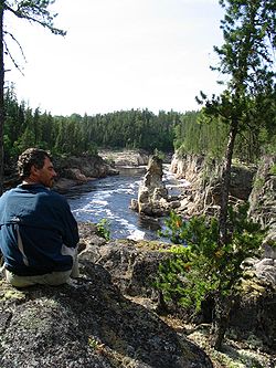
Today, the river is used for canoeing
Canoeing
Canoeing is an outdoor activity that involves a special kind of canoe.Open canoes may be 'poled' , sailed, 'lined and tracked' or even 'gunnel-bobbed'....
, fishing and camping. Recreational use is facilitated by an arrangement which allows canoeists to load their boats on a train so they can be returned south, after canoeing the wild stretches of the river. The river is managed as a provincial waterway park and was designated as a Canadian Heritage River
Canadian Heritage Rivers System
The Canadian Heritage Rivers System was established in 1984 by the federal, provincial and territorial governments to conserve and protect the best examples of Canada's river heritage, to give them national recognition, and to encourage the public to enjoy and appreciate them. It is a cooperative...
in 2004.
Tributaries
- Brunswick River
- Fire River
- Hay River
- Mattawitchewan River
- Albany Forks
- Oba River, Oba Lake
- Albany Forks
- Pivabiska River
- Opasatika River
- Soweska River
Missinaibi Provincial Park
The entire length of the Missinaibi River from Missinaibi Lake to the Moose River is protected and part of the Missinaibi Provincial Park. The park also includes Missinaibi Lake, Brunswick River, Brunswick Lake, Little Missinaibi River, and Little Missinaibi Lake.External links
- Ontario Parks - Missinaibi Prov. Park official website
- Snow Falling on Black Spruce- A Northern Ontario Canoe Sojourn Down the Missinaibi
- Missinaibi Complete - Missinaibi canoe trip July 1-22, 2004