
Minnesota Valley National Wildlife Refuge
Encyclopedia
The Minnesota Valley National Wildlife Refuge is a 14,000 acre (57 km2) National Wildlife Refuge
in central Minnesota
. There are eight refuge units strung along 34 miles (54.7 km) of the Minnesota River
. Located just south of the city of Minneapolis
, this is one of only four American national wildlife refuges in an urban area, and the largest. The visitor center
is located just blocks from the Mall of America
. The parklands stretch southwest through Minneapolis’ outer-ring suburbs to Jordan, Minnesota
. The various refuge units are interspersed with units of the Minnesota Valley State Recreation Area
. Although the national wildlife refuge is managed by the United States Fish and Wildlife Service
and the state recreation area by the Minnesota Department of Natural Resources
, both agencies share a consistent signage to simplify visitation.
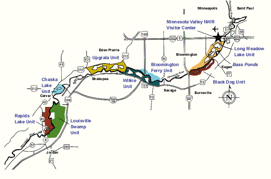 Listed east to west:
, is the most visited in the refuge. Lakes and ponds surrounded by wetlands are bordered by floodplain forest.
11 miles (17.7 km) of trails lead into the valley from the visitor center and three other access points. Pedestrians and bicyclists can cross the Cedar Avenue Bridge
into Fort Snelling State Park
. An interpretive trail circles the man-made Bass Ponds, where the Izaak Walton League
raised several fish species to stock lakes statewide from 1926 to the 1950s. Map
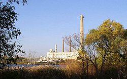 This 1,400 acre (5.7 km2) unit surrounds Black Dog Lake, on the right bank of the Minnesota River in Burnsville
. The lake is named after Chief Black Dog, leader of a band of Mdewakanton Sioux
who formed a permanent summer village here around 1750 and later sold game to American soldiers and settlers at Fort Snelling
. The unit preserves prairie and calcareous fen
. Xcel Energy
’s Black Dog Power Plant rises in the center of the unit. Clean wastewater from the plant is pumped into Black Dog Lake so it may cool before reentering the Minnesota River. Because of this certain waterfowl remain on the lake longer into the winter. The unit was created in 1982 when Xcel Energy agreed to lease the lands to the Fish and Wildlife Service. The southwestern corner of the unit is managed as Black Dog Nature Preserve Scientific and Natural Area by the Minnesota DNR.
A two-mile (3 km) trail runs through wetlands south of the lake. There is parking at either end of the trail, off River Hills Dr and Cliff Rd. There is an observation platform on the north shore of the lake off Black Dog Rd. Map
and Shakopee
, contain marshes, bottomland forest, and three lakes. The state’s largest great blue heron
rookery
, with over 600 nests, is found here. Because disturbances negatively affect the birds’ breeding, the west end of the unit is closed to the public from March 1 to August 31. Five miles of trail and abandoned farm roads are open for hiking and cross-country skiing year-round. Map
.
and Carver
was acquired in 2001. On the left bank of the Minnesota River, this unit contains a marsh-edged lake, floodplain forest, and old fields. The fields are being restored to floodplain forest. A two mile (3 km) trail runs through these habitats. There is parking at either end, at the Chaska Ballpark and Riverside Park in Carver. Map
 The centerpiece of this 2,600 acre (11 km2) unit is the marsh called Louisville Swamp. FWS staff estimate that Louisville Swamp floods three out of every five years, and trail closures are common. A water control structure helps regulate the outflow into Sand Creek, a short course which flows into the Minnesota River. The unit also includes dry lands above the bluffs which bear old fields, prairie, and oak savanna. The unit is located on the right bank of the river just north of Jordan, Minnesota
.
There was once a Wahpeton Sioux
village called Inyan Ceyaka Otonwe
, or Little Rapids, here. The unit’s Mazomani Trail is named after a Wahpeton chief. Jean-Baptiste Faribault
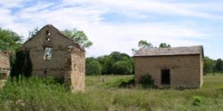
built a fur trading post near the village in 1802 and lived here for seven years. The exact site of the village and trading post are lost, but the remains of two historic farmsteads are still visible. The Ehmiller Farmstead is in ruins, but at the Jabs Farm two buildings have been restored and a third stabilized. The barn was built in 1880 by Robert and Anna Riedel. Frederick Jabs bought the 379 acre (1.5 km2) farmstead in 1905 and his family lived there as subsistence farmers until 1952.
The unit has thirteen miles (19 km) of trail for hiking and cross-country skiing. The parking lot for this unit is a few dozen yards past the Minnesota Renaissance Festival parking. Traffic during the festival (weekends from mid-August through September) significantly impedes access to the Louisville Swamp unit. Map
There are three miles (5 km) of trails in the unit. The two access points are on County Road 45, two miles (3 km) apart.
Long Meadow Lake is spanned by a wood and steel bridge built in 1920. Known as the Old Cedar Avenue Bridge, it was turned over to the city of Bloomington in 1979 when the Minnesota Department of Transportation
constructed a new bridge nearby. In poor repair, the old bridge was closed to vehicle traffic in 1993 but remained a crucial link for pedestrians and cyclists until officials closed the bridge entirely in 2002. The refuge managers, Bloomington and Eagan officials, and public interest groups have all expressed a desire to replace the unsafe bridge, but funds have not been yet been secured to remove the old bridge, much less build a new one.
In the late 1990s the Minneapolis-Saint Paul International Airport
planned a new runway which would route air traffic over parts of the refuge. A real estate appraisal
firm arbitrated a settlement to compensate the refuge for the environmental impact of the noise pollution
. The airport’s commission voted unanimously to accept the settlement in 1998 and ultimately paid $26 million into a trust. Some of that money was used in 2004 and 2005 to purchase 420 acres (1.7 km2) between the Chaska and Rapids Lake Units.
National Wildlife Refuge
National Wildlife Refuge is a designation for certain protected areas of the United States managed by the United States Fish and Wildlife Service. The National Wildlife Refuge System is the world's premiere system of public lands and waters set aside to conserve America's fish, wildlife and plants...
in central Minnesota
Minnesota
Minnesota is a U.S. state located in the Midwestern United States. The twelfth largest state of the U.S., it is the twenty-first most populous, with 5.3 million residents. Minnesota was carved out of the eastern half of the Minnesota Territory and admitted to the Union as the thirty-second state...
. There are eight refuge units strung along 34 miles (54.7 km) of the Minnesota River
Minnesota River
The Minnesota River is a tributary of the Mississippi River, approximately 332 miles long, in the U.S. state of Minnesota. It drains a watershed of nearly , in Minnesota and about in South Dakota and Iowa....
. Located just south of the city of Minneapolis
Minneapolis, Minnesota
Minneapolis , nicknamed "City of Lakes" and the "Mill City," is the county seat of Hennepin County, the largest city in the U.S. state of Minnesota, and the 48th largest in the United States...
, this is one of only four American national wildlife refuges in an urban area, and the largest. The visitor center
Visitor center
A visitor center or centre , visitor information center, tourist information center, is a physical location that provides tourist information to the visitors who tour the place or area locally...
is located just blocks from the Mall of America
Mall of America
The Mall of America, also called MOA and the Megamall, is a shopping mall located in Bloomington, Minnesota, a suburb of the Twin Cities, in the United States. It is located southeast of the junction of Interstate 494 and Minnesota State Highway 77, north of the Minnesota River and is across the...
. The parklands stretch southwest through Minneapolis’ outer-ring suburbs to Jordan, Minnesota
Jordan, Minnesota
Jordan is a city in Scott County, Minnesota, United States. The population was 5,470 at the 2010 census.-Geography:According to the United States Census Bureau, the city has a total area of , of which, of it is land and of it is water. U.S. Highway 169; and State Highways 21 and 282 are three...
. The various refuge units are interspersed with units of the Minnesota Valley State Recreation Area
Minnesota Valley State Recreation Area
Minnesota Valley State Recreation Area is a member of the Minnesota state park system. The park is not continuous but is composed of waysides, four of which are strung along the Minnesota River between Shakopee and Belle Plaine. The various waysides are interspersed with units of the Minnesota...
. Although the national wildlife refuge is managed by the United States Fish and Wildlife Service
United States Fish and Wildlife Service
The United States Fish and Wildlife Service is a federal government agency within the United States Department of the Interior dedicated to the management of fish, wildlife, and natural habitats...
and the state recreation area by the Minnesota Department of Natural Resources
Minnesota Department of Natural Resources
The Minnesota Department of Natural Resources is the agency of the U.S. state of Minnesota charged with conserving and managing the state's natural resources. The agency maintains areas such as state parks, state forests, recreational trails, and recreation areas as well as managing minerals,...
, both agencies share a consistent signage to simplify visitation.
Refuge units
Long Meadow Lake Unit
This 2,400 acre (9.7 km2) unit, on the left bank of the Minnesota River in BloomingtonBloomington, Minnesota
Bloomington is the fifth largest city in the U.S. state of Minnesota in Hennepin County. Located on the north bank of the Minnesota River above its confluence with the Mississippi River, Bloomington lies at the heart of the southern...
, is the most visited in the refuge. Lakes and ponds surrounded by wetlands are bordered by floodplain forest.
11 miles (17.7 km) of trails lead into the valley from the visitor center and three other access points. Pedestrians and bicyclists can cross the Cedar Avenue Bridge
Cedar Avenue Bridge (Minnesota River)
The Cedar Avenue Bridge carries Minnesota State Highway 77 across the Minnesota River between the Minneapolis-St. Paul suburbs of Bloomington and Eagan, Minnesota. The two parallel crossings for northbound and southbound lanes are respectively 5,159 feet and 5,185 feet in length...
into Fort Snelling State Park
Fort Snelling State Park
Fort Snelling State Park is a state park of Minnesota, USA, at the confluence of the Mississippi and Minnesota rivers. Its most notable feature is the historic Fort Snelling, which dates from 1820. The fort itself is operated by the Minnesota Historical Society and requires a separate entrance fee...
. An interpretive trail circles the man-made Bass Ponds, where the Izaak Walton League
Izaak Walton League
The Izaak Walton League is an American environmental organization founded in 1922 that promotes natural resource protection and outdoor recreation. The organization was founded in Chicago, Illinois by a group of sportsmen who wished to protect fishing opportunities for future generations...
raised several fish species to stock lakes statewide from 1926 to the 1950s. Map
Black Dog Preserve
Burnsville, Minnesota
Burnsville is a city south of downtown Minneapolis in Dakota County in the U.S. state of Minnesota. The city lies on the south bank of the Minnesota River, upstream from the confluence with the Mississippi River...
. The lake is named after Chief Black Dog, leader of a band of Mdewakanton Sioux
Sioux
The Sioux are Native American and First Nations people in North America. The term can refer to any ethnic group within the Great Sioux Nation or any of the nation's many language dialects...
who formed a permanent summer village here around 1750 and later sold game to American soldiers and settlers at Fort Snelling
Fort Snelling, Minnesota
Fort Snelling, originally known as Fort Saint Anthony, was a military fortification located at the confluence of the Minnesota River and Mississippi River in Hennepin County, Minnesota...
. The unit preserves prairie and calcareous fen
Fen
A fen is a type of wetland fed by mineral-rich surface water or groundwater. Fens are characterised by their water chemistry, which is neutral or alkaline, with relatively high dissolved mineral levels but few other plant nutrients...
. Xcel Energy
Xcel Energy
Xcel Energy, Inc. is a public utility company based in Minneapolis, Minnesota, serving customers in Colorado, Michigan, Minnesota, New Mexico, North Dakota, South Dakota, Texas, and Wisconsin. Primary services are electricity and natural gas...
’s Black Dog Power Plant rises in the center of the unit. Clean wastewater from the plant is pumped into Black Dog Lake so it may cool before reentering the Minnesota River. Because of this certain waterfowl remain on the lake longer into the winter. The unit was created in 1982 when Xcel Energy agreed to lease the lands to the Fish and Wildlife Service. The southwestern corner of the unit is managed as Black Dog Nature Preserve Scientific and Natural Area by the Minnesota DNR.
A two-mile (3 km) trail runs through wetlands south of the lake. There is parking at either end of the trail, off River Hills Dr and Cliff Rd. There is an observation platform on the north shore of the lake off Black Dog Rd. Map
Bloomington Ferry Unit
The unit, located in the southwest corner of Bloomington, comprises 400 acres (1.6 km2) of marsh and floodplain forest. From a parking area there is a half-mile (800 m) trail along the riverbank and a bridge to the Wilkie Unit. Map
Wilkie Unit
These 2,100 acres (8.5 km2), just south of the river in SavageSavage, Minnesota
Savage is a suburban city south-southwest of downtown Minneapolis in Scott County in the U.S. state of Minnesota. The city is situated on the south bank of the Minnesota River in a region commonly referred to as South of the River, comprising the southern portion of Minneapolis-St. Paul, the...
and Shakopee
Shakopee, Minnesota
Shakopee is a city southwest of downtown Minneapolis in the U.S. state of Minnesota and is the county seat of Scott County. Located on the south bank bend of the Minnesota River, Shakopee and nearby suburbs comprise the southwest portion of Minneapolis-Saint Paul, the thirteenth largest...
, contain marshes, bottomland forest, and three lakes. The state’s largest great blue heron
Great Blue Heron
The Great Blue Heron is a large wading bird in the heron family Ardeidae, common near the shores of open water and in wetlands over most of North and Central America as well as the West Indies and the Galápagos Islands. It is a rare vagrant to Europe, with records from Spain, the Azores and England...
rookery
Rookery
A rookery is a colony of breeding animals, generally birds. A rook is a Northern European and Central Asian member of the crow family, which nest in prominent colonies at the tops of trees. The term is applied to the nesting place of birds, such as crows and rooks, the source of the term...
, with over 600 nests, is found here. Because disturbances negatively affect the birds’ breeding, the west end of the unit is closed to the public from March 1 to August 31. Five miles of trail and abandoned farm roads are open for hiking and cross-country skiing year-round. Map
Upgrala Unit
Although 2,450 acres (9.9 km2) are authorized for this unit, most of the land has not yet been acquired from private owners. There is currently no public access to this mosaic of marshes, ponds, fields, and floodplain forest. The authorized area for this unit stretches from the old Highway 169 bridge (now County Road 101) north of Shakopee and eastward along the bluffs in the southern part of Eden Prairie, MinnesotaEden Prairie, Minnesota
As of the census of 2000, there were 54,901 people, 20,457 households, and 14,579 families residing in the city. The population density was . There were 21,026 housing units at an average density of 649.2 per square mile...
.
Chaska Unit
This 600 acre (2.4 km2) unit between ChaskaChaska, Minnesota
As of 2005, there were 22,467 people and 8,194 households residing in the city. The population density was 1,640 people per square mile . There were 6,235 housing units at an average density of 454.1 per square mile...
and Carver
Carver, Minnesota
As of the census of 2000, there were 1,266 people, 458 households, and 349 families residing in the city. The population density was 328.6 people per square mile . There were 467 housing units at an average density of 121.2 per square mile...
was acquired in 2001. On the left bank of the Minnesota River, this unit contains a marsh-edged lake, floodplain forest, and old fields. The fields are being restored to floodplain forest. A two mile (3 km) trail runs through these habitats. There is parking at either end, at the Chaska Ballpark and Riverside Park in Carver. Map
Louisville Swamp Unit
Jordan, Minnesota
Jordan is a city in Scott County, Minnesota, United States. The population was 5,470 at the 2010 census.-Geography:According to the United States Census Bureau, the city has a total area of , of which, of it is land and of it is water. U.S. Highway 169; and State Highways 21 and 282 are three...
.
There was once a Wahpeton Sioux
Sioux
The Sioux are Native American and First Nations people in North America. The term can refer to any ethnic group within the Great Sioux Nation or any of the nation's many language dialects...
village called Inyan Ceyaka Otonwe
Inyan Ceyaka Otonwe
Inyan Ceyaka Otonwe or Little Rapids is the site of a nineteenth century village of Dakotah people known as Wahpeton or People of Leaves. The site is located near the east bank of the Minnesota River about four miles north of Jordan, Minnesota....
, or Little Rapids, here. The unit’s Mazomani Trail is named after a Wahpeton chief. Jean-Baptiste Faribault
Jean-Baptiste Faribault
Jean-Baptiste Faribault was a trader with the Indians and early settler in Minnesota.His father, Barthélemy Faribault, a lawyer of Paris, France, settled in Canada towards the middle of the 18th century and served as military secretary to the French army in Canada...
built a fur trading post near the village in 1802 and lived here for seven years. The exact site of the village and trading post are lost, but the remains of two historic farmsteads are still visible. The Ehmiller Farmstead is in ruins, but at the Jabs Farm two buildings have been restored and a third stabilized. The barn was built in 1880 by Robert and Anna Riedel. Frederick Jabs bought the 379 acre (1.5 km2) farmstead in 1905 and his family lived there as subsistence farmers until 1952.
The unit has thirteen miles (19 km) of trail for hiking and cross-country skiing. The parking lot for this unit is a few dozen yards past the Minnesota Renaissance Festival parking. Traffic during the festival (weekends from mid-August through September) significantly impedes access to the Louisville Swamp unit. Map
Rapids Lake Unit
This new and relatively undeveloped 1,480 acre (6 km2) unit is on the left bank of the river across from the Louisville Swamp Unit . Old fields are being restored to prairie and oak savanna. There is also bottomland forest and a wetland restored in 1992. Part of the unit was once a turkey farm. The FWS has constructed a new visitor center (for the proposal see: proposal). The center includes a new visitor center, an outdoor education center, and a bunkhouse for interns in this unit.There are three miles (5 km) of trails in the unit. The two access points are on County Road 45, two miles (3 km) apart.
History
Early plans to create a park along the Minnesota River were forestalled by World War II. It wasn’t until the early 1970s that the threat of development inspired concerted efforts to preserve the valley. An act creating the national wildlife refuge was passed in 1976.Long Meadow Lake is spanned by a wood and steel bridge built in 1920. Known as the Old Cedar Avenue Bridge, it was turned over to the city of Bloomington in 1979 when the Minnesota Department of Transportation
Minnesota Department of Transportation
The Minnesota Department of Transportation oversees transportation by land, water, and air in the U.S. state of Minnesota. The cabinet-level agency is responsible for maintaining the state's trunk highway system The Minnesota Department of Transportation (Mn/DOT, pronounced "min-dot") oversees...
constructed a new bridge nearby. In poor repair, the old bridge was closed to vehicle traffic in 1993 but remained a crucial link for pedestrians and cyclists until officials closed the bridge entirely in 2002. The refuge managers, Bloomington and Eagan officials, and public interest groups have all expressed a desire to replace the unsafe bridge, but funds have not been yet been secured to remove the old bridge, much less build a new one.
In the late 1990s the Minneapolis-Saint Paul International Airport
Minneapolis-Saint Paul International Airport
Minneapolis-Saint Paul International Airport is the largest and busiest airport in the five-state upper Midwest region of Minnesota, Iowa, South Dakota, North Dakota, and Wisconsin.-Overview:...
planned a new runway which would route air traffic over parts of the refuge. A real estate appraisal
Real estate appraisal
Real estate appraisal, property valuation or land valuation is the process of valuing real property. The value usually sought is the property's Market Value. Appraisals are needed because compared to, say, corporate stock, real estate transactions occur very infrequently...
firm arbitrated a settlement to compensate the refuge for the environmental impact of the noise pollution
Noise pollution
Noise pollution is excessive, displeasing human, animal or machine-created environmental noise that disrupts the activity or balance of human or animal life...
. The airport’s commission voted unanimously to accept the settlement in 1998 and ultimately paid $26 million into a trust. Some of that money was used in 2004 and 2005 to purchase 420 acres (1.7 km2) between the Chaska and Rapids Lake Units.