

Minnesota State Highway 210
Encyclopedia
Minnesota State Highway 210 is a highway
in west-central, central, and northeast Minnesota
, which runs from North Dakota Highway 210
at the North Dakota
state line (at Breckenridge
), and continues east to its eastern terminus at its intersection
with State Highway 23
in Duluth
(Fond du Lac
) near the Saint Louis River
.
The route runs across Minnesota from west-central to northeast; connecting Fergus Falls
, Brainerd
, and Duluth
.
At the western terminus of Highway 210, upon crossing the Red River
, the roadway becomes North Dakota Highway 210 and feeds into North Dakota Highway 13
.
Highway 210 is 228 miles (366.9 km) in length.
 Highway 210 serves as an east–west route in west-central, central, and northeast Minnesota between Breckenridge
, Fergus Falls
, Staples
, Baxter
, Brainerd
, Carlton
, and Duluth
.
For part of its route (7-miles), Highway 210 is concurrent
with U.S. Highway 10
between Motley
and Staples
in central Minnesota
.
The route crosses the Washington Street Bridge
at the Mississippi River
in Brainerd
.
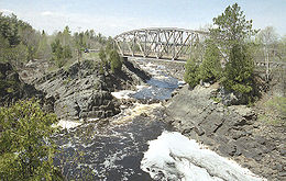
Highway 210 crosses the Saint Louis River
in Thomson
.
The portion of Highway 210 in Aitkin County
is officially designated the Dale Wayrynen
Memorial Highway. This same designation is also signed on Highway 210 in Carlton County
from Cromwell
westbound to the county line with Aitkin County.
Highway 210 passes through the Cuyuna Range
in Crow Wing County
and the Fond du Lac State Forest
in Carlton County
.
Cuyuna Country State Recreation Area
is located on Highway 210 in Crow Wing County
. The park is located near Crosby
and Ironton
; northeast of Brainerd
.
Jay Cooke State Park
is located on Highway 210 in Carlton County
. The park is located between Carlton
and Fond du Lac
(Duluth
).
Highway 210 is also known as:
(now Highway 45
) in Carlton and Highway 23
in Duluth, acting as an eastern extension of U.S. Highway 210. Circa 1955, the highway was expanded on the west end of U.S. 210, replacing former State Highway 3 from Staples to the North Dakota state line at Breckenridge. The original eastern segment was subsequently renumbered as part of Highway 39
in 1956.
When U.S. 210 was removed in 1970, the highway was redesignated State Highway 210. The historic original route of Minnesota 210 between Carlton and Duluth was changed back at this time as well.
 Minnesota 210 from Carlton to Motley, the eastern portion of the present day highway, was originally part of U.S. Route 210 from 1926 to 1970.
During 1970, U.S. Route 210 was decommissioned
from Carlton to Motley and re-designated Minnesota 210 that same year.
U.S. Route 210 was originally commissioned in 1926 by AASHTO, the American Association of State Highway and Transportation Officials, as one of the original U.S. Routes.
). Ultimately, U.S. Route 10 was routed along former U.S. Route 10N in Minnesota. U.S. Route 208 was shown on some maps in the mid 1930s running from Carlton to Motley in Minnesota, but the number was not officially commissioned or signed, and Highway 210 kept its number.
as built westward from Carlton to Staples
. Between Henning
and Breckenridge
, the highway runs along a former branch line of the Northern Pacific Railway. Most of the branch line has since been abandoned.
The western section of the highway, between Breckenridge and Fergus Falls
, was originally part of Minnesota Constitutional Route 3. Between Fergus Falls and Henning, the highway was part of Constitutional Route 36. The section between Carlton and Motley was part of Constitutional Route 2.
|colspan=2|Red River of the North
|0.000
|
|
|-
|-
|rowspan=3|Brainerd
|122.095-122.215
|colspan=2|Washington Street Bridge
over the Mississippi River
Highway
A highway is any public road. In American English, the term is common and almost always designates major roads. In British English, the term designates any road open to the public. Any interconnected set of highways can be variously referred to as a "highway system", a "highway network", or a...
in west-central, central, and northeast Minnesota
Minnesota
Minnesota is a U.S. state located in the Midwestern United States. The twelfth largest state of the U.S., it is the twenty-first most populous, with 5.3 million residents. Minnesota was carved out of the eastern half of the Minnesota Territory and admitted to the Union as the thirty-second state...
, which runs from North Dakota Highway 210
North Dakota Highway 210
North Dakota Highway 210 is a short highway that serves as a bypass of the Wahpeton, North Dakota and Breckenridge, Minnesota.-Route Description:The western terminus is located near Wahpeton, with Highway 13 traveling west and north of the city...
at the North Dakota
North Dakota
North Dakota is a state located in the Midwestern region of the United States of America, along the Canadian border. The state is bordered by Canada to the north, Minnesota to the east, South Dakota to the south and Montana to the west. North Dakota is the 19th-largest state by area in the U.S....
state line (at Breckenridge
Breckenridge, Minnesota
As of the census of 2000, there were 3,559 people, 1,438 households, and 911 families residing in the city. The population density was 1,516.4 people per square mile . There were 1,582 housing units at an average density of 674.0 per square mile...
), and continues east to its eastern terminus at its intersection
Intersection (road)
An intersection is a road junction where two or more roads either meet or cross at grade . An intersection may be 3-way - a T junction or fork, 4-way - a crossroads, or 5-way or more...
with State Highway 23
Minnesota State Highway 23
Minnesota State Highway 23 is a state highway that stretches from southwest to northeast Minnesota. At in length, it is the second longest state route in Minnesota, after MN 1....
in Duluth
Duluth, Minnesota
Duluth is a port city in the U.S. state of Minnesota and is the county seat of Saint Louis County. The fourth largest city in Minnesota, Duluth had a total population of 86,265 in the 2010 census. Duluth is also the second largest city that is located on Lake Superior after Thunder Bay, Ontario,...
(Fond du Lac
Fond du Lac (Duluth)
Fond du Lac is a neighborhood in Duluth, Minnesota, United States.Evergreen Memorial Highway serves as a main arterial route in the community.-History:...
) near the Saint Louis River
Saint Louis River
The St. Louis River is a river in the U.S. states of Minnesota and Wisconsin that flows into Lake Superior. The largest U.S. river to flow into the lake, it is 179 miles in length and starts near Hoyt Lakes, Minnesota. The river's watershed is in area...
.
The route runs across Minnesota from west-central to northeast; connecting Fergus Falls
Fergus Falls, Minnesota
Fergus Falls is a city in and the county seat of Otter Tail County, Minnesota, United States. The population was 13,138 at the 2010 census.-Today:...
, Brainerd
Brainerd, Minnesota
Brainerd is a city in Crow Wing County, Minnesota, United States. The population was 13,590 at the 2010 census. It is the county seat of Crow Wing County and one of the largest cities in Central Minnesota...
, and Duluth
Duluth, Minnesota
Duluth is a port city in the U.S. state of Minnesota and is the county seat of Saint Louis County. The fourth largest city in Minnesota, Duluth had a total population of 86,265 in the 2010 census. Duluth is also the second largest city that is located on Lake Superior after Thunder Bay, Ontario,...
.
At the western terminus of Highway 210, upon crossing the Red River
Red River of the North
The Red River is a North American river. Originating at the confluence of the Bois de Sioux and Otter Tail rivers in the United States, it flows northward through the Red River Valley and forms the border between the U.S. states of Minnesota and North Dakota before continuing into Manitoba, Canada...
, the roadway becomes North Dakota Highway 210 and feeds into North Dakota Highway 13
North Dakota Highway 13
North Dakota Highway 13 is an long highway that serves southeast North Dakota. For the most part, the highway is a rural 2-lane road, but the final east of I-29 is a four-lane divided road. Its eastern terminus is located at its junction with ND 210...
.
Highway 210 is 228 miles (366.9 km) in length.
Route description
Breckenridge, Minnesota
As of the census of 2000, there were 3,559 people, 1,438 households, and 911 families residing in the city. The population density was 1,516.4 people per square mile . There were 1,582 housing units at an average density of 674.0 per square mile...
, Fergus Falls
Fergus Falls, Minnesota
Fergus Falls is a city in and the county seat of Otter Tail County, Minnesota, United States. The population was 13,138 at the 2010 census.-Today:...
, Staples
Staples, Minnesota
As of the census of 2000, there were 3,104 people, 1,278 households, and 732 families residing in the city. The population density was 684.5 people per square mile . There were 1,436 housing units at an average density of 316.7 per square mile...
, Baxter
Baxter, Minnesota
As of the census of 2000, there were 5,555 people, 1,921 households, and 1,586 families residing in the city. The population density was 320.7 people per square mile . There were 1,979 housing units at an average density of 114.3 per square mile...
, Brainerd
Brainerd, Minnesota
Brainerd is a city in Crow Wing County, Minnesota, United States. The population was 13,590 at the 2010 census. It is the county seat of Crow Wing County and one of the largest cities in Central Minnesota...
, Carlton
Carlton, Minnesota
Carlton is a city in Carlton County, Minnesota, United States. The population was 862 at the 2010 census. It is the county seat of Carlton County.Minnesota State Highways 45 and 210; and County Roads 1 and 3 are four of the main routes in the community....
, and Duluth
Duluth, Minnesota
Duluth is a port city in the U.S. state of Minnesota and is the county seat of Saint Louis County. The fourth largest city in Minnesota, Duluth had a total population of 86,265 in the 2010 census. Duluth is also the second largest city that is located on Lake Superior after Thunder Bay, Ontario,...
.
For part of its route (7-miles), Highway 210 is concurrent
Concurrency (road)
A concurrency, overlap, or coincidence in a road network is an instance of one physical road bearing two or more different highway, motorway, or other route numbers...
with U.S. Highway 10
U.S. Route 10 in Minnesota
U.S. Route 10 is a major divided highway for almost all of its length in the U.S. state of Minnesota. The route runs through the central portion of the state, following closely the alignment of the former Northern Pacific Railway and connects the cities of Moorhead, Detroit Lakes, Wadena, Little...
between Motley
Motley, Minnesota
As of the census of 2000, there were 585 people, 258 households, and 167 families residing in the city. The population density was 442.7 people per square mile . There were 270 housing units at an average density of 204.3 per square mile...
and Staples
Staples, Minnesota
As of the census of 2000, there were 3,104 people, 1,278 households, and 732 families residing in the city. The population density was 684.5 people per square mile . There were 1,436 housing units at an average density of 316.7 per square mile...
in central Minnesota
Central Minnesota
Central Minnesota is the name of the region consisting of the central portion of the state of Minnesota. Although no specific boundaries of the region exist, most definitions of what makes up the region would generally consist of the vast swath of land north of Interstate 94, east of U.S. Highway...
.
The route crosses the Washington Street Bridge
Washington Street Bridge
The Washington Street Bridge was built 1932-1934 in Brainerd in the U.S. state of Minnesota. It carries four lanes of Minnesota State Highway 210 across the Upper Mississippi River....
at the Mississippi River
Mississippi River
The Mississippi River is the largest river system in North America. Flowing entirely in the United States, this river rises in western Minnesota and meanders slowly southwards for to the Mississippi River Delta at the Gulf of Mexico. With its many tributaries, the Mississippi's watershed drains...
in Brainerd
Brainerd, Minnesota
Brainerd is a city in Crow Wing County, Minnesota, United States. The population was 13,590 at the 2010 census. It is the county seat of Crow Wing County and one of the largest cities in Central Minnesota...
.
Highway 210 crosses the Saint Louis River
Saint Louis River
The St. Louis River is a river in the U.S. states of Minnesota and Wisconsin that flows into Lake Superior. The largest U.S. river to flow into the lake, it is 179 miles in length and starts near Hoyt Lakes, Minnesota. The river's watershed is in area...
in Thomson
Thomson, Minnesota
Thomson is a city in Carlton County, Minnesota, USA, along the St. Louis River. The population was 159 at the 2010 census.Thomson is adjacent to Jay Cooke State Park and is located on the Willard Munger State Trail....
.
The portion of Highway 210 in Aitkin County
Aitkin County, Minnesota
Aitkin County is a county located in the U.S. state of Minnesota. As of 2010, the population is 16,202. Its county seat is Aitkin. A portion of the Mille Lacs Indian Reservation is in the county.-History:...
is officially designated the Dale Wayrynen
Dale Eugene Wayrynen
Dale Eugene Wayrynen was a United States Army enlisted soldier and a recipient of America's highest military decoration — the Medal of Honor — for his actions in the Vietnam War.-Biography:...
Memorial Highway. This same designation is also signed on Highway 210 in Carlton County
Carlton County, Minnesota
As of the census of 2000, there were 31,671 people, 12,064 households, and 8,408 families residing in the county. The population density was 37 people per square mile . There were 13,721 housing units at an average density of 16 per square mile...
from Cromwell
Cromwell, Minnesota
Cromwell is a city in Carlton County, Minnesota, United States. The population was 234 at the 2010 census.Minnesota State Highways 73 and 210 are two of the main arterial routes in the community.-Geography:...
westbound to the county line with Aitkin County.
Highway 210 passes through the Cuyuna Range
Cuyuna Range
The Cuyuna Range is an iron range to the southwest of the Mesabi Range, largely within Crow Wing County, Minnesota. It lies along a line between Brainerd and Aitkin, although those communities are not mining towns....
in Crow Wing County
Crow Wing County, Minnesota
Crow Wing County is a county located in the U.S. state of Minnesota. As of 2010, the population was 62,500. Its county seat is Brainerd.-Geography:...
and the Fond du Lac State Forest
Fond du Lac State Forest
The Fond du Lac State Forest is a state forest in Minnesota, USA, principally managed by the Minnesota Department of Natural Resources . The main segment of the forest is located between the towns of Sawyer and Cromwell, in Carlton County. The boundaries of the forest overlap with those of the Fond...
in Carlton County
Carlton County, Minnesota
As of the census of 2000, there were 31,671 people, 12,064 households, and 8,408 families residing in the county. The population density was 37 people per square mile . There were 13,721 housing units at an average density of 16 per square mile...
.
Cuyuna Country State Recreation Area
Cuyuna Country State Recreation Area
Cuyuna Country State Recreation Area is a state park unit of Minnesota, USA, being developed to rehabilitate a portion of the Cuyuna Range where mining pits and piles of waste rock were left behind after decades of open-pit mining for iron ore...
is located on Highway 210 in Crow Wing County
Crow Wing County, Minnesota
Crow Wing County is a county located in the U.S. state of Minnesota. As of 2010, the population was 62,500. Its county seat is Brainerd.-Geography:...
. The park is located near Crosby
Crosby, Minnesota
As of the census of 2000, there were 2,299 people, 989 households, and 554 families residing in the city. The population density was 755.0 people per square mile . There were 1,081 housing units at an average density of 355.0 per square mile...
and Ironton
Ironton, Minnesota
As of the census of 2000, there were 498 people, 231 households, and 130 families residing in the city. The population density was 333.2 people per square mile . There were 263 housing units at an average density of 176.0 per square mile . The racial makeup of the city was 99.40% White, 0.40%...
; northeast of Brainerd
Brainerd, Minnesota
Brainerd is a city in Crow Wing County, Minnesota, United States. The population was 13,590 at the 2010 census. It is the county seat of Crow Wing County and one of the largest cities in Central Minnesota...
.
Jay Cooke State Park
Jay Cooke State Park
Jay Cooke State Park is a Minnesota state park located about ten miles southwest of Duluth, just outside the small town of Thomson. Jay Cooke is situated on the St...
is located on Highway 210 in Carlton County
Carlton County, Minnesota
As of the census of 2000, there were 31,671 people, 12,064 households, and 8,408 families residing in the county. The population density was 37 people per square mile . There were 13,721 housing units at an average density of 16 per square mile...
. The park is located between Carlton
Carlton, Minnesota
Carlton is a city in Carlton County, Minnesota, United States. The population was 862 at the 2010 census. It is the county seat of Carlton County.Minnesota State Highways 45 and 210; and County Roads 1 and 3 are four of the main routes in the community....
and Fond du Lac
Fond du Lac (Duluth)
Fond du Lac is a neighborhood in Duluth, Minnesota, United States.Evergreen Memorial Highway serves as a main arterial route in the community.-History:...
(Duluth
Duluth, Minnesota
Duluth is a port city in the U.S. state of Minnesota and is the county seat of Saint Louis County. The fourth largest city in Minnesota, Duluth had a total population of 86,265 in the 2010 census. Duluth is also the second largest city that is located on Lake Superior after Thunder Bay, Ontario,...
).
Highway 210 is also known as:
- Second Avenue North and Sixth Street in StaplesStaples, MinnesotaAs of the census of 2000, there were 3,104 people, 1,278 households, and 732 families residing in the city. The population density was 684.5 people per square mile . There were 1,436 housing units at an average density of 316.7 per square mile...
. - Washington Street in BrainerdBrainerd, MinnesotaBrainerd is a city in Crow Wing County, Minnesota, United States. The population was 13,590 at the 2010 census. It is the county seat of Crow Wing County and one of the largest cities in Central Minnesota...
. - Chestnut Avenue in CarltonCarlton, MinnesotaCarlton is a city in Carlton County, Minnesota, United States. The population was 862 at the 2010 census. It is the county seat of Carlton County.Minnesota State Highways 45 and 210; and County Roads 1 and 3 are four of the main routes in the community....
. - Rushing Rapids Parkway (for 9-miles) between CarltonCarlton, MinnesotaCarlton is a city in Carlton County, Minnesota, United States. The population was 862 at the 2010 census. It is the county seat of Carlton County.Minnesota State Highways 45 and 210; and County Roads 1 and 3 are four of the main routes in the community....
and Fond du LacFond du Lac (Duluth)Fond du Lac is a neighborhood in Duluth, Minnesota, United States.Evergreen Memorial Highway serves as a main arterial route in the community.-History:...
(DuluthDuluth, MinnesotaDuluth is a port city in the U.S. state of Minnesota and is the county seat of Saint Louis County. The fourth largest city in Minnesota, Duluth had a total population of 86,265 in the 2010 census. Duluth is also the second largest city that is located on Lake Superior after Thunder Bay, Ontario,...
).
History
State Highway 210 was authorized on July 1, 1949 between then-U.S. 61U.S. Route 61 in Minnesota
U.S. Highway 61 is a highway in southeast and east-central Minnesota, which runs from the River Bridge over the Mississippi River at La Crescent and continues north to its northern terminus at its junction with Interstate 35 at the city of Wyoming....
(now Highway 45
Minnesota State Highway 45
Minnesota State Highway 45 is a short highway in northeast Minnesota, which runs from its intersection with State Highway 210 and Carlton County Road 1 in the city of Carlton and continues north to its northern terminus at its interchange with Interstate 35 and Carlton County Highway 45 in the...
) in Carlton and Highway 23
Minnesota State Highway 23
Minnesota State Highway 23 is a state highway that stretches from southwest to northeast Minnesota. At in length, it is the second longest state route in Minnesota, after MN 1....
in Duluth, acting as an eastern extension of U.S. Highway 210. Circa 1955, the highway was expanded on the west end of U.S. 210, replacing former State Highway 3 from Staples to the North Dakota state line at Breckenridge. The original eastern segment was subsequently renumbered as part of Highway 39
Minnesota State Highway 39
Minnesota State Highway 39 is a short highway in northeast Minnesota, which runs from its intersection with State Highway 23 in Duluth and continues east to its eastern terminus at the Wisconsin state line , where it becomes Wisconsin Highway 105 upon entering the village of Oliver, Wisconsin.The...
in 1956.
When U.S. 210 was removed in 1970, the highway was redesignated State Highway 210. The historic original route of Minnesota 210 between Carlton and Duluth was changed back at this time as well.
U.S. 210
During 1970, U.S. Route 210 was decommissioned
Decommissioned highway
A decommissioned highway is a highway that has been removed from service, shut down or has had its authorization as a federal or state highway removed. Decommissioning can include the complete or partial demolition or abandonment of an old highway structure because the old roadway has lost its...
from Carlton to Motley and re-designated Minnesota 210 that same year.
U.S. Route 210 was originally commissioned in 1926 by AASHTO, the American Association of State Highway and Transportation Officials, as one of the original U.S. Routes.
U.S. 210 and U.S. 208
Originally, U.S. Route 210 from Carlton to Motley was slated to be re-numbered U.S. Route 208 in the 1934 numbering plan. The road was almost re-numbered because of a routing change in its parent road (U.S. Route 10U.S. Route 10 in Minnesota
U.S. Route 10 is a major divided highway for almost all of its length in the U.S. state of Minnesota. The route runs through the central portion of the state, following closely the alignment of the former Northern Pacific Railway and connects the cities of Moorhead, Detroit Lakes, Wadena, Little...
). Ultimately, U.S. Route 10 was routed along former U.S. Route 10N in Minnesota. U.S. Route 208 was shown on some maps in the mid 1930s running from Carlton to Motley in Minnesota, but the number was not officially commissioned or signed, and Highway 210 kept its number.
Route Description History
Highway 210 runs along the original mainline of the Northern Pacific RailwayNorthern Pacific Railway
The Northern Pacific Railway was a railway that operated in the west along the Canadian border of the United States. Construction began in 1870 and the main line opened all the way from the Great Lakes to the Pacific when former president Ulysses S. Grant drove in the final "golden spike" in...
as built westward from Carlton to Staples
Staples, Minnesota
As of the census of 2000, there were 3,104 people, 1,278 households, and 732 families residing in the city. The population density was 684.5 people per square mile . There were 1,436 housing units at an average density of 316.7 per square mile...
. Between Henning
Henning, Minnesota
Henning is a city in Otter Tail County, Minnesota, United States. The population was 802 at the 2010 census.-Geography:According to the United States Census Bureau, the city has a total area of , all of it land....
and Breckenridge
Breckenridge, Minnesota
As of the census of 2000, there were 3,559 people, 1,438 households, and 911 families residing in the city. The population density was 1,516.4 people per square mile . There were 1,582 housing units at an average density of 674.0 per square mile...
, the highway runs along a former branch line of the Northern Pacific Railway. Most of the branch line has since been abandoned.
The western section of the highway, between Breckenridge and Fergus Falls
Fergus Falls, Minnesota
Fergus Falls is a city in and the county seat of Otter Tail County, Minnesota, United States. The population was 13,138 at the 2010 census.-Today:...
, was originally part of Minnesota Constitutional Route 3. Between Fergus Falls and Henning, the highway was part of Constitutional Route 36. The section between Carlton and Motley was part of Constitutional Route 2.
Major intersections
|-|colspan=2|Red River of the North
Red River of the North
The Red River is a North American river. Originating at the confluence of the Bois de Sioux and Otter Tail rivers in the United States, it flows northward through the Red River Valley and forms the border between the U.S. states of Minnesota and North Dakota before continuing into Manitoba, Canada...
|0.000
|
|
|-
|-
|rowspan=3|Brainerd
Brainerd, Minnesota
Brainerd is a city in Crow Wing County, Minnesota, United States. The population was 13,590 at the 2010 census. It is the county seat of Crow Wing County and one of the largest cities in Central Minnesota...
|122.095-122.215
|colspan=2|Washington Street Bridge
Washington Street Bridge
The Washington Street Bridge was built 1932-1934 in Brainerd in the U.S. state of Minnesota. It carries four lanes of Minnesota State Highway 210 across the Upper Mississippi River....
over the Mississippi River
Mississippi River
The Mississippi River is the largest river system in North America. Flowing entirely in the United States, this river rises in western Minnesota and meanders slowly southwards for to the Mississippi River Delta at the Gulf of Mexico. With its many tributaries, the Mississippi's watershed drains...