
.gif)
Milton Keynes (borough)
Encyclopedia
The Borough of Milton Keynes is a unitary authority
and borough
in south central England
, at the northern tip of the South East England
Region
. For ceremonial purposes
, it is in the county of Buckinghamshire
. It is the most northerly district of the South East region.
It borders the non-metropolitan counties of Buckinghamshire (the area under the control of Buckinghamshire County Council), Bedfordshire
and Northamptonshire
. The principal settlement in the borough is Milton Keynes
itself, which accounts for about 33% of its area and 90% of its population.
, by the merger of Bletchley Urban District
, Newport Pagnell Urban District
and Wolverton Urban District
, Newport Pagnell Rural District
and that part of Wing Rural District
within the designated New Town area. The district council applied for and received borough status
that year.
It was originally one of five non-metropolitan district
s of Buckinghamshire
, but on 1 April 1997, under a recommendation of the Local Government Commission for England
it became a self-governing unitary authority
, independent from Buckinghamshire County Council
. The borough however remains part of Buckinghamshire for ceremonial purposes
.
and is currently governed by a Conservative minority administration. The Liberal Democrats party is currently the main opposition group.
The political composition for the council is as follows.
(GVA) of Milton Keynes at current basic prices published (pp. 240–253) by Office for National Statistics with figures in millions of British Pounds Sterling (except GVA index).
1 Components may not sum to totals due to rounding
2 includes hunting and forestry
3 includes energy and construction
4 includes financial intermediation services indirectly measured
5 UK average index base = 100
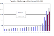
estimated the Borough's population at 224,500, making it the 54th-largest authority in England by population. Using Census 2001
data the ONS estimated the population of the contiguous built-up area to be 184,506.
New 2009 population estimates have been released by the Office for National Statistics. They show that the Milton Keynes population was estimated to be 236,700 in 2009.
By 2026, the population of the borough is projected to be 323,146.
In the 2001 census 90.72% of the population described their ethnic origin as white (nationally 90.92%), 3.66% as South Asian (4.58%), 2.41% as black (2.30%), 1.79% as mixed race (1.31%), 1.42% as Chinese and other (0.89%). In the same census, 66% of the Borough's population registered their religion as Christianity
and 30% as not religious or none given, compared to 72% and 22% nationally. A little over two percent of the population follow Islam
(3% nationally) and a little over 1% are Hindu
(1%), with no other religion above one percent.
The borough’s population age profile is younger than that for England as a whole, with half of the borough’s population aged under 35 years old (the median
age). [Nationally, half of the population is aged less than 38]. The 35-44 year olds in Milton Keynes Borough can be seen as the largest 10-year age group of the population with 35-39 year olds being the largest 5-year age group.
.
 The Borough of Milton Keynes is fully parished
. These are the parishes, and the districts they contain, that are now elements of Milton Keynes as a whole.
Unitary authority
A unitary authority is a type of local authority that has a single tier and is responsible for all local government functions within its area or performs additional functions which elsewhere in the relevant country are usually performed by national government or a higher level of sub-national...
and borough
Borough
A borough is an administrative division in various countries. In principle, the term borough designates a self-governing township although, in practice, official use of the term varies widely....
in south central England
England
England is a country that is part of the United Kingdom. It shares land borders with Scotland to the north and Wales to the west; the Irish Sea is to the north west, the Celtic Sea to the south west, with the North Sea to the east and the English Channel to the south separating it from continental...
, at the northern tip of the South East England
South East England
South East England is one of the nine official regions of England, designated in 1994 and adopted for statistical purposes in 1999. It consists of Berkshire, Buckinghamshire, East Sussex, Hampshire, Isle of Wight, Kent, Oxfordshire, Surrey and West Sussex...
Region
Regions of England
In England, the region is the highest tier of sub-national division used by central Government. Between 1994 and 2011, the nine regions had an administrative role in the implementation of UK Government policy, and as the areas covered by elected bodies...
. For ceremonial purposes
Ceremonial counties of England
The ceremonial counties are areas of England to which are appointed a Lord Lieutenant, and are defined by the government as counties and areas for the purposes of the Lieutenancies Act 1997 with reference to the metropolitan and non-metropolitan counties of England and Lieutenancies Act 1997...
, it is in the county of Buckinghamshire
Buckinghamshire
Buckinghamshire is a ceremonial and non-metropolitan home county in South East England. The county town is Aylesbury, the largest town in the ceremonial county is Milton Keynes and largest town in the non-metropolitan county is High Wycombe....
. It is the most northerly district of the South East region.
It borders the non-metropolitan counties of Buckinghamshire (the area under the control of Buckinghamshire County Council), Bedfordshire
Bedfordshire
Bedfordshire is a ceremonial county of historic origin in England that forms part of the East of England region.It borders Cambridgeshire to the north-east, Northamptonshire to the north, Buckinghamshire to the west and Hertfordshire to the south-east....
and Northamptonshire
Northamptonshire
Northamptonshire is a landlocked county in the English East Midlands, with a population of 629,676 as at the 2001 census. It has boundaries with the ceremonial counties of Warwickshire to the west, Leicestershire and Rutland to the north, Cambridgeshire to the east, Bedfordshire to the south-east,...
. The principal settlement in the borough is Milton Keynes
Milton Keynes
Milton Keynes , sometimes abbreviated MK, is a large town in Buckinghamshire, in the south east of England, about north-west of London. It is the administrative centre of the Borough of Milton Keynes...
itself, which accounts for about 33% of its area and 90% of its population.
History
The district was created on 1 April 1974 under the Local Government Act 1972Local Government Act 1972
The Local Government Act 1972 is an Act of Parliament in the United Kingdom that reformed local government in England and Wales on 1 April 1974....
, by the merger of Bletchley Urban District
Bletchley Urban District
Fenny Stratford Urban District was from 1895 to 1911 the name of a local government authority in the administrative county of Buckinghamshire, England. In 1911 the urban district was renamed Bletchley Urban District....
, Newport Pagnell Urban District
Newport Pagnell Urban District
Newport Pagnell Urban District was a local government authority in the administrative county of Buckinghamshire, England, from 1897 to 1974....
and Wolverton Urban District
Wolverton Urban District
Stratford and Wolverton Rural District , Stratford and Wolverton Urban District and Wolverton Urban District were local government districts in Buckinghamshire, England, covering the town of Wolverton and its environs.It was created as a rural district in 1894 and took over the responsibility for...
, Newport Pagnell Rural District
Newport Pagnell Rural District
Newport Pagnell was a rural district in the administrative county of Buckinghamshire, England, from 1894 to 1974. The rural district took over the responsibilities of the disbanded Newport Pagnell Rural Sanitary District...
and that part of Wing Rural District
Wing Rural District
Wing Rural District was a rural district in the administrative county of Buckinghamshire, England from 1894 to 1974.It was created under the Local Government Act 1894 from the parts of both the Leighton Buzzard and the Berkhampstead Rural Sanitary Districts that were in Buckinghamshire...
within the designated New Town area. The district council applied for and received borough status
Borough status in the United Kingdom
Borough status in the United Kingdom is granted by royal charter to local government districts in England, Wales and Northern Ireland. The status is purely honorary, and does not give any additional powers to the council or inhabitants of the district...
that year.
It was originally one of five non-metropolitan district
Non-metropolitan district
Non-metropolitan districts, or colloquially shire districts, are a type of local government district in England. As created, they are sub-divisions of non-metropolitan counties in a so-called "two-tier" arrangement...
s of Buckinghamshire
Buckinghamshire
Buckinghamshire is a ceremonial and non-metropolitan home county in South East England. The county town is Aylesbury, the largest town in the ceremonial county is Milton Keynes and largest town in the non-metropolitan county is High Wycombe....
, but on 1 April 1997, under a recommendation of the Local Government Commission for England
Local Government Commission for England (1992)
The Local Government Commission for England was the body responsible for reviewing the structure of local government in England from 1992 to 2002. It was established under the Local Government Act 1992, replacing the Local Government Boundary Commission for England...
it became a self-governing unitary authority
Unitary authority
A unitary authority is a type of local authority that has a single tier and is responsible for all local government functions within its area or performs additional functions which elsewhere in the relevant country are usually performed by national government or a higher level of sub-national...
, independent from Buckinghamshire County Council
Buckinghamshire County Council
Buckinghamshire County Council is the upper-tier local authority for the non-metropolitan county of Buckinghamshire, in England, the United Kingdom. Its area of control does not include Milton Keynes, which is a unitary authority...
. The borough however remains part of Buckinghamshire for ceremonial purposes
Ceremonial counties of England
The ceremonial counties are areas of England to which are appointed a Lord Lieutenant, and are defined by the government as counties and areas for the purposes of the Lieutenancies Act 1997 with reference to the metropolitan and non-metropolitan counties of England and Lieutenancies Act 1997...
.
Local government
Milton Keynes council is under no overall controlNo overall control
Within the context of local councils of the United Kingdom, the term No Overall Control refers to a situation in which no single party achieves a majority of seats and is analogous to a hung parliament...
and is currently governed by a Conservative minority administration. The Liberal Democrats party is currently the main opposition group.
The political composition for the council is as follows.
| Date | Conservatives Conservative Party (UK) The Conservative Party, formally the Conservative and Unionist Party, is a centre-right political party in the United Kingdom that adheres to the philosophies of conservatism and British unionism. It is the largest political party in the UK, and is currently the largest single party in the House... | Liberal Democrats | Labour Labour Party (UK) The Labour Party is a centre-left democratic socialist party in the United Kingdom. It surpassed the Liberal Party in general elections during the early 1920s, forming minority governments under Ramsay MacDonald in 1924 and 1929-1931. The party was in a wartime coalition from 1940 to 1945, after... | Independents Independent (politician) In politics, an independent or non-party politician is an individual not affiliated to any political party. Independents may hold a centrist viewpoint between those of major political parties, a viewpoint more extreme than any major party, or they may have a viewpoint based on issues that they do... |
|---|---|---|---|---|
| 6 May 2011 | 21 | 17 | 9 | 4 |
Economy
This is a table of trend of regional gross value addedGross value added
Gross Value Added ' is a measure in economics of the value of goods and services produced in an area, industry or sector of an economy...
(GVA) of Milton Keynes at current basic prices published (pp. 240–253) by Office for National Statistics with figures in millions of British Pounds Sterling (except GVA index).
| Year | Regional Gross Value Added | Agriculture | Industry | Services | GVA index per person |
|---|---|---|---|---|---|
| 1995 | 2,834 | 7 | 751 | 2,075 | 135 |
| 2000 | 4,166 | 5 | 805 | 3,356 | 141 |
| 2003 | 5,203 | 7 | 852 | 4,344 | 147 |
1 Components may not sum to totals due to rounding
2 includes hunting and forestry
3 includes energy and construction
4 includes financial intermediation services indirectly measured
5 UK average index base = 100
Demographics
In 2006 the Office for National StatisticsOffice for National Statistics
The Office for National Statistics is the executive office of the UK Statistics Authority, a non-ministerial department which reports directly to the Parliament of the United Kingdom.- Overview :...
estimated the Borough's population at 224,500, making it the 54th-largest authority in England by population. Using Census 2001
United Kingdom Census 2001
A nationwide census, known as Census 2001, was conducted in the United Kingdom on Sunday, 29 April 2001. This was the 20th UK Census and recorded a resident population of 58,789,194....
data the ONS estimated the population of the contiguous built-up area to be 184,506.
New 2009 population estimates have been released by the Office for National Statistics. They show that the Milton Keynes population was estimated to be 236,700 in 2009.
By 2026, the population of the borough is projected to be 323,146.
In the 2001 census 90.72% of the population described their ethnic origin as white (nationally 90.92%), 3.66% as South Asian (4.58%), 2.41% as black (2.30%), 1.79% as mixed race (1.31%), 1.42% as Chinese and other (0.89%). In the same census, 66% of the Borough's population registered their religion as Christianity
Christianity
Christianity is a monotheistic religion based on the life and teachings of Jesus as presented in canonical gospels and other New Testament writings...
and 30% as not religious or none given, compared to 72% and 22% nationally. A little over two percent of the population follow Islam
Islam
Islam . The most common are and . : Arabic pronunciation varies regionally. The first vowel ranges from ~~. The second vowel ranges from ~~~...
(3% nationally) and a little over 1% are Hindu
Hindu
Hindu refers to an identity associated with the philosophical, religious and cultural systems that are indigenous to the Indian subcontinent. As used in the Constitution of India, the word "Hindu" is also attributed to all persons professing any Indian religion...
(1%), with no other religion above one percent.
The borough’s population age profile is younger than that for England as a whole, with half of the borough’s population aged under 35 years old (the median
Median
In probability theory and statistics, a median is described as the numerical value separating the higher half of a sample, a population, or a probability distribution, from the lower half. The median of a finite list of numbers can be found by arranging all the observations from lowest value to...
age). [Nationally, half of the population is aged less than 38]. The 35-44 year olds in Milton Keynes Borough can be seen as the largest 10-year age group of the population with 35-39 year olds being the largest 5-year age group.
Milton Keynes (urban area)
The urban area accounts for about 33% of the Borough by area and 90% by population. This is a partial list of the districts of Milton Keynes itself. For a discussion of the usage of the term "city" in Milton Keynes, see History of Milton KeynesHistory of Milton Keynes
Milton Keynes is a large town in South East England, founded in 1967. This history of Milton Keynes details its development from the earliest human settlements, through the plans for a 'new city' for 250,000 people in south central England, its subsequent urban design and development, to the...
.
Civil parish
In England, a civil parish is a territorial designation and, where they are found, the lowest tier of local government below districts and counties...
. These are the parishes, and the districts they contain, that are now elements of Milton Keynes as a whole.
- Bletchley and Fenny StratfordBletchley and Fenny StratfordBletchley and Fenny Stratford is a civil parish with a town council, in Milton Keynes, Buckinghamshire, England. It was formed in 2001 from the unparished area of Milton Keynes, and according to the 2001 census had a population of 13,971....
: Brickfields, Central Bletchley, Denbigh, Mount Farm, Fenny Lock, Granby, Fenny StratfordFenny StratfordFenny Stratford is a constituent town of Milton Keynes, ceremonial county of Buckinghamshire, England and in the Civil Parish of Bletchley and Fenny Stratford. Originally an independent town, it was included in the Milton Keynes "designated area" area in 1967...
, Water EatonWater Eaton, Milton KeynesWater Eaton is an area of Milton Keynes, Buckinghamshire, England and in the civil parish of Bletchley and Fenny Stratford. It is to the south of Fenny Stratford, and is one of the ancient villages of Buckinghamshire that became incorporated as part of Milton Keynes in 1967.By the date of... - BradwellBradwell, Milton KeynesBradwell is an ancient village and modern civil parish that is part of Milton Keynes . For a time, although it predates it, Bradwell was the supporting village for Bradwell Abbey, a Benedictine priory, founded in 1155 and dissolved in about 1540.The village name is an Old English language word...
: Bradwell, Bradwell Common, Bradwell village, Heelands, Rooksley - Bradwell AbbeyBradwell AbbeyBradwell Abbey or Bradwell Priory is a Scheduled Ancient Monument, urban studies site, district and civil parish in Milton Keynes, ceremonial Buckinghamshire, England. The site was once the location of a Benedictine priory, founded in 1155....
: Bradwell Abbey, Kiln Farm, Stacey Bushes, Two Mile Ash, Wymbush - BroughtonBroughton, Milton KeynesBroughton is a historic village in North Buckinghamshire that has been a constituent element of Milton Keynes since the latter's designation in 1967; a civil parish; and modernly a suburb and new district of the 'city'.-History and Location:...
and Milton Keynes (the Village) a shared parish council: Atterbury, Brook Furlong, BroughtonBroughton, Milton KeynesBroughton is a historic village in North Buckinghamshire that has been a constituent element of Milton Keynes since the latter's designation in 1967; a civil parish; and modernly a suburb and new district of the 'city'.-History and Location:...
, Fox Milne, Middleton, Milton KeynesMiddleton, Milton KeynesMiddleton is a district in Milton Keynes, Buckinghamshire, England. The district is centred on Milton Keynes Village, the village that gave its name to the 'New City' of Milton Keynes, which began to be developed during the late 1960s...
, Milton Keynes Village, Northfield, Oakgrove, Pineham - Campbell ParkCampbell ParkCampbell Park is a district in east-central and south-central Milton Keynes, Buckinghamshire, England, the central park for Milton Keynes, and a civil parish that includes other districts. According to the 2001 census the parish had a population of 13,364...
: Campbell Park, Elfield Park, Fishermead, Newlands, Oldbrook, Springfield, Willen and Willen LakeWillenWillen is a district of Milton Keynes, England and is also one of the ancient villages of Buckinghamshire to have been included in the designated area of the New City in1967...
, Winterhill - Central Milton KeynesCentral Milton KeynesCentral Milton Keynes is the central business district of Milton Keynes, Buckinghamshire, England and a civil parish in its own right.The district is approximately 2.5 km long by 1 km wide and occupies some of the highest land in Milton Keynes...
- Great LinfordGreat LinfordGreat Linford is a historic village, district and civil parish in the northern part of Milton Keynes, England, between Wolverton and Newport Pagnell.-Great Linford village:...
: Blakelands, Conniburrow, Downs Barn, Downhead Park, Giffard Park, Great Linford, Neath Hill, PennylandPennyland projectThe Pennyland project was one of a series of low-energy building experiments sparked by the 1973 oil crisis. It involved the construction of an estate of 177 houses in the Pennyland area of Milton Keynes, Buckinghamshire, United Kingdom...
, Tongwell, Willen Park - Kents Hill, Monkston and BrinklowKents Hill, Monkston and BrinklowKents Hill, Monkston and Brinklow is a civil parish in Milton Keynes, Buckinghamshire, England. It was formed in 2001 as part of a general parishing of the Borough. The population according to the 2001 census was 4,545....
: Brinklow, Kents Hill, Kingston, Monkston - LoughtonLoughton, Milton KeynesLoughton is an ancient village, modern district and civil parish in Milton Keynes, Buckinghamshire, England. The village spreads between Watling Street and the modern A5 road, to the west of, and about 1 mile from, the city centre....
: Loughton, Loughton Lodge, Great Holm, the BowlNational BowlThe National Bowl is an entertainment venue in Milton Keynes, Buckinghamshire, England. The site was a former clay-pit , filled in and raised to form an amphitheatre using sub-soil excavated by the many new developments in the area and it has a current maximum capacity of 65,000... - New BradwellNew BradwellNew Bradwell is a Victorian era new village, modern district and civil parish that is now part of Milton Keynes , on its northern edge...
- Shenley Brook EndShenley Brook EndShenley Brook End is a village, district and civil parish in Milton Keynes, Buckinghamshire, England. Together with its neighbouring parish, Shenley Church End and the districts of Shenley Wood and Shenley Lodge, the districts are collectively known as "The Shenleys".The name 'Shenley' is an Old...
: Emerson Valley, FurztonFurztonFurzton is a district in West Milton Keynes, Buckinghamshire, England and in the civil parish of Shenley Brook End. The man-made Furzton Lake is a balancing lake that covers approximately half of the district.-History:...
, Kingsmead, Shenley Brook End, Snelshall, TattenhoeTattenhoeTattenhoe and Tattenhoe Park are adjacent districts of Milton Keynes, England, in the ancient parish of Tattenhoe. It is located at the south-western edge of the city, not far from the ruins of Snelshall Priory...
, Tattenhoe Park, WestcroftWestcroftWestcroft is a district in the west side of Milton Keynes, in the civil parish of Shenley Brook End.Westcroft District Centre is a large retail development that serves this side of Milton Keynes... - Shenley Church EndShenley Church EndShenley Church End is a village, district and civil parish in Milton Keynes England. Together with its neighbouring parish, Shenley Brook End and the districts of Shenley Wood and Shenley Lodge, the districts are collectively known as "The Shenleys".-History:...
: Crownhill, Grange Farm, Hazeley, Medbourne, Oakhill, Oxley, Shenley Church End, Woodhill - SimpsonSimpson, Milton KeynesSimpson is a village and civil parish in Milton Keynes, Buckinghamshire, England. It was one of the former villages of Buckinghamshire that was included in the New City in 1967. It is located south of the centre, just north of Fenny Stratford, near Walton....
: Ashland, Simpson, West Ashland - StantonburyStantonburyStantonbury is a district of Milton Keynes, ceremonial Buckinghamshire, England. It is situated at the northern edge, between Great Linford and Wolverton...
: BancroftBancroft-People:*The Bancroft family, previous owners of Dow Jones & Company*Aaron Bancroft , Colonial American clergyman and Revolutionary War soldier*Ann Bancroft -People:*The Bancroft family, previous owners of Dow Jones & Company*Aaron Bancroft (1755-1839), Colonial American clergyman and Revolutionary...
/Bancroft Park, Blue Bridge, Bradville, Linford Wood, Stantonbury, Stantonbury Fields - Stony StratfordStony StratfordStony Stratford is a constituent town of Milton Keynes and is a civil parish with a town council within the Borough of Milton Keynes. It is in the north west corner of Milton Keynes, bordering Northamptonshire and separated from it by the River Great Ouse...
: Fullers Slade, Galley Hill, Stony Stratford - Walton: Caldecotte, Old Farm Park, Tilbrook, Tower Gate, Walnut Tree, Walton, Walton HallWalton Hall, Milton KeynesWalton Hall is a district in Milton Keynes, in the English county of Buckinghamshire, and is the location of the campus and offices of The Open University. The University campus covers 48 hectares and the first buildings were designed by Maxwell Fry & Jane Drew in 1969.It is in the ancient parish...
, Walton Park, Wavendon Gate - West BletchleyWest BletchleyWest Bletchley is a district and civil parish that covers the western part of Bletchley, a constituent town of Milton Keynes in Buckinghamshire, England. The parish covers that part of Bletchley that is south of Standing Way , west of the West Coast Main Line and north of Water Eaton Brook...
: Far Bletchley, Old Bletchley, West Bletchley. - Wolverton and GreenleysWolverton and GreenleysWolverton and Greenleys is a civil parish with a Town Council in the borough of Milton Keynes, England. It is north-west of central Milton Keynes, and according to the 2001 census had a population of 8,253...
: Greenleys, Stonebridge, WolvertonWolvertonWolverton is part of Milton Keynes, Buckinghamshire, England.Wolverton may also refer to:Places in England:*Wolverton, Dorset*Wolverton, Kent*Wolverton, Hampshire*Wolverton, Shropshire*Wolverton, WarwickshirePlaces in the United States:...
, Old Wolverton - WoughtonWoughtonWoughton is a civil parish in south central Milton Keynes, ceremonial county of Buckinghamshire, England. It takes its name from the original ecclesiastic parish of Woughton and its original village, Woughton on the Green....
: Beanhill, Bleak Hall, Coffee Hall, Eaglestone, Leadenhall, Netherfield, Peartree Bridge, Redmoor, Tinkers Bridge, Woughton on the Green, Woughton Park, Woughton village.
- Newport PagnellNewport PagnellNewport Pagnell is a town in the Borough of Milton Keynes , England. It is separated by the M1 motorway from Milton Keynes itself, though part of the same urban area...
lies within the Milton Keynes urban areaMilton Keynes urban areaMilton Keynes is a large town in Buckinghamshire. The Milton Keynes urban area is a designation established by the United Kingdom's Office of National Statistics. As with other urban areas, it includes settlements that regard themselves as being outside Milton Keynes...
as defined by the Office of National Statistics but is outside the 1967 'designated area' and is thus generally accepted as separate.
Rest of the borough
The rural area accounts for about 66% of the Borough by area and about 10% by population. These are the extra-urban civil parishes:- AstwoodAstwoodAstwood is a village and civil parish in the Borough of Milton Keynes, ceremonial Buckinghamshire, England, on the border with Bedfordshire.The village name is Anglo Saxon and means Eastern Wood....
- Bow BrickhillBow BrickhillBow Brickhill is a village and civil parish in the Borough of Milton Keynes, Buckinghamshire, England. It is a short distance south east of Milton Keynes itself....
- CaldecoteCaldecote, Milton KeynesCaldecote is a tiny hamlet in Newport Pagnell parish in the Borough of Milton Keynes and ceremonial county of Buckinghamshire, England.The place name is fairly common in England, and is Old English meaning "cold cottage". This refers to a resting place for travellers or other strangers on the...
, CastlethorpeCastlethorpeCastlethorpe is a village and civil parish with a population of about 1000 in the Borough of Milton Keynes , England. It is about north-east of Stony Stratford, north-west of Newport Pagnell and north of Central Milton Keynes...
, ChicheleyChicheleyChicheley is a village and civil parish in the Borough of Milton Keynes, Buckinghamshire, England. The village is about 2½ miles north east of Newport Pagnell.The village name is Anglo Saxon in origin, and means Cicca's clearing...
, Clifton ReynesClifton ReynesClifton Reynes is a village in the Borough of Milton Keynes, in the ceremonial county of Buckinghamshire, England. It is about a mile east of Olney...
, Cold BrayfieldCold BrayfieldCold Brayfield is a village and civil parish in the Borough of Milton Keynes, Buckinghamshire, England. It is about three miles east of Olney, on the Bedfordshire border. Nearby places are Lavendon and Turvey .Cold Brayfield is probably the place named as 'Bragenfelda' in a charter of 967... - EmbertonEmbertonEmberton is a village and civil parish in the Borough of Milton Keynes, ceremonial county of Buckinghamshire in England. The village is near the border with Northamptonshire, just to the south of Olney and four miles north of Newport Pagnell....
- FilgraveFilgraveFilgrave is a village in the Borough of Milton Keynes and ceremonial Buckinghamshire, England. It is about three miles north of Newport Pagnell.The village name is an Old English language word, and means 'Fygla's grove'...
- GayhurstGayhurstGayhurst is a village and civil parish in the Borough of Milton Keynes, ceremonial Buckinghamshire in England. It is about two and a half miles NNW of Newport Pagnell....
- HanslopeHanslopeHanslope is a village in the Borough of Milton Keynes and is the centre of a Civil Parish of the same name. It is about 4 miles WNW of Newport Pagnell, about 4 miles north of Stony Stratford, about 8 miles north of Central Milton Keynes and just south of Northamptonshire. For ceremonial...
, HardmeadHardmeadHardmead is a small village and civil parish in the Borough of Milton Keynes and ceremonial county of Buckinghamshire, England. It is in the north of the Borough, about seven miles west of Bedford, five miles north east of Newport Pagnell...
, HavershamHavershamHaversham is a village in the Borough of Milton Keynes, Buckinghamshire, England. It is situated just north of Milton Keynes near Wolverton and lies between Newport Pagnell and Stony Stratford. Haversham-cum-Little Linford is a civil parish in the Borough of Milton Keynes.The village has two... - LathburyLathburyLathbury is a village and civil parish in the Borough of Milton Keynes and ceremonial county of Buckinghamshire, England. It is just to the north of Newport Pagnell....
, LavendonLavendonLavendon is a village and civil parish in the Borough of Milton Keynes and ceremonial county of Buckinghamshire, England. It is the northernmost village in the Borough, near Olney, eight miles WNW of Bedford, eight miles NNE of Newport Pagnell....
, Little BrickhillLittle BrickhillLittle Brickhill is a village and civil parish in the Borough of Milton Keynes and ceremonial county of Buckinghamshire, England. It is just outside and overlooking Milton Keynes itself, two and a half miles west of Woburn in Bedfordshire....
, Little LinfordLittle LinfordLittle Linford is a village in the Borough of Milton Keynes and ceremonial county of Buckinghamshire, England. It is about a mile west of Newport Pagnell, near the M1 motorway. Unlike its neighbour and namesake Great Linford it has yet to be joined up with Milton Keynes.Little Linford was...
, Long StreetLong StreetLong Street is a hamlet in the parish of Hanslope, in the Borough of Milton Keynes, ceremonial Buckinghamshire, England. It is located on the road that leads from Hanslope to Northampton. The hamlet is named for the road on which the hamlet is located....
, - MoulsoeMoulsoeMoulsoe is a village and civil parish in the Borough of Milton Keynes and ceremonial county of Buckinghamshire, England. It is on the border with Bedfordshire, just across the M1 from Milton Keynes itself, and about two and a half miles ESE of Newport Pagnell....
- Newton BlossomvilleNewton BlossomvilleNewton Blossomville is a village in the Borough of Milton Keynes and ceremonial county of Buckinghamshire, England. It is a civil parish, sharing a joint parish council with Clifton Reynes...
, North CrawleyNorth CrawleyNorth Crawley is a village and civil parish in the Borough of Milton Keynes and ceremonial county of Buckinghamshire, England. It is located near the border with Bedfordshire, about three and a half miles east of Newport Pagnell.... - Olney
- Ravenstone
- SheringtonSheringtonSherington is a village and civil parish in the Borough of Milton Keynes and ceremonial county of Buckinghamshire, England. It is located just north west of Newport Pagnell, by the A509....
, Stoke GoldingtonStoke GoldingtonStoke Goldington is a village and civil parish in the Borough of Milton Keynes and ceremonial county of Buckinghamshire, England. It is located about four miles NNW of Newport Pagnell, on the B526, the old road to Northampton....
, - TyringhamTyringhamTyringham is a village in the Borough of Milton Keynes and ceremonial county of Buckinghamshire, England. It is located about a mile and a half north of Newport Pagnell.The village name is an Old English language word, and means 'Tir's home'...
- Warrington, Weston Underwood, Woburn SandsWoburn SandsWoburn Sands is a small town and civil parish that is mainly located in the Borough of Milton Keynes, England, and to the south-east of Milton Keynes itself, near Wavendon...