
.gif)
Military Demarcation Line (Korea)
Encyclopedia
The Military Demarcation Line (MDL), sometimes referred to as the Armistice Line, is the land border or demarcation line
between North Korea
and South Korea
. On either side of the line is the Korean Demilitarized Zone
(DMZ). The MDL and DMZ were established by the Armistice at the end of Korean War
in 1953.
In the Yellow Sea, the two Koreas are divided by a de facto maritime "military demarcation line" and maritime boundary called the Northern Limit Line
(NLL) drawn by the United Nations Command in 1953. The NLL is not described by the Korean Armistice Agreement.
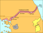
 The DMZ runs near the 38th parallel, covering roughly 248 kilometers. American
and South Korea
n soldiers patrol this line along the South Korean side while North Korea
n soldiers patrol along the North Korean side.
In Korean
, the line is called the Hyujeonseon (휴전선), meaning "armistice line." It is also sometimes called the Gunsa Bungye-seon (군사분계선), which literally means "military demarcation line." However, in colloquial usage, the dividing line is more often called the Sampalseon (삼팔선, "38th parallel
"), a name likely coined at the end of World War II, when it would have been an accurate description of the North-South border.
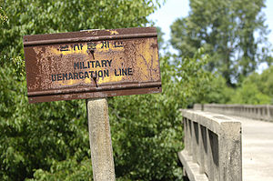
The line itself is marked off by a series of 1,292 identical signs which are placed at intervals across the peninsula. The north facing side of the signs are written in Chosongul and Chinese, and in Hangul and English on the south facing side. The signs are aging and rusting.
.
which defines the MDL; and 21st century scholarly/academic secondary source
s continue to recognize this as fundamental. The Armistice is monitored by members of the Neutral Nations Supervisory Commission
composed of members from the Swiss and Swedish Armed Forces.
Military Demarcation Line is a de jure
term and MDL is an explicit acronym which remain valid today because no mutually acceptable changes have been made. The use of the term or acronym or line which is not explicitly mentioned in the 1953 KAA is not verifiable within the ambit of the primary source text.
The unresolved aftermath of the Korean War has revealed unique, region-specific facets of this conflict. Although the Korean Armistice Agreement specifies where the demarcation line
and demilitarized zone are located on land, the agreement does not mention lines or zones in adjacent ocean waters.
In 1999, North Korea unilaterally asserted its own "North Korean Military Demarcation Line in the West Sea (Yellow Sea)", also called the "Inter-Korean MDL in the Yellow Sea".
The 1953 MDL is a demarcation line, and the 1953 NLL is a demarcation line as well; however, the MDL is a different line than the NLL. The 1999 North Korean MDL is also distinct. Across a span of decades, precision has been blurred by conventional usage and reports in the popular press.
After more than fifty years, the South Koreans have come to construe a de-facto western inter-Korean border which has remained unchanged since 1953. The map at the right shows that the ambits of the NLL and North Korea's maritime MDL represent overlapping jurisdictional claims. The DPRK rejected the NLL and only recognized the demarcation line it drew in 1999, which was further south of the NLL.
Demarcation line
A demarcation line means simply a boundary around a specific area, but is commonly used to denote a temporary geopolitical border, often agreed upon as part of an armistice or ceasefire.See the following examples:...
between North Korea
North Korea
The Democratic People’s Republic of Korea , , is a country in East Asia, occupying the northern half of the Korean Peninsula. Its capital and largest city is Pyongyang. The Korean Demilitarized Zone serves as the buffer zone between North Korea and South Korea...
and South Korea
South Korea
The Republic of Korea , , is a sovereign state in East Asia, located on the southern portion of the Korean Peninsula. It is neighbored by the People's Republic of China to the west, Japan to the east, North Korea to the north, and the East China Sea and Republic of China to the south...
. On either side of the line is the Korean Demilitarized Zone
Korean Demilitarized Zone
The Korean Demilitarized Zone is a strip of land running across the Korean Peninsula that serves as a buffer zone between North and South Korea. The DMZ cuts the Korean Peninsula roughly in half, crossing the 38th parallel on an angle, with the west end of the DMZ lying south of the parallel and...
(DMZ). The MDL and DMZ were established by the Armistice at the end of Korean War
Korean War
The Korean War was a conventional war between South Korea, supported by the United Nations, and North Korea, supported by the People's Republic of China , with military material aid from the Soviet Union...
in 1953.
In the Yellow Sea, the two Koreas are divided by a de facto maritime "military demarcation line" and maritime boundary called the Northern Limit Line
Northern Limit Line
The Northern Limit Line or North Limit Line is a disputed inter-Korea maritime demarcation line in the Yellow Sea between the Democratic People's Republic of Korea on the north, and the Republic of Korea on the south...
(NLL) drawn by the United Nations Command in 1953. The NLL is not described by the Korean Armistice Agreement.
Demarcation on land
United States
The United States of America is a federal constitutional republic comprising fifty states and a federal district...
and South Korea
South Korea
The Republic of Korea , , is a sovereign state in East Asia, located on the southern portion of the Korean Peninsula. It is neighbored by the People's Republic of China to the west, Japan to the east, North Korea to the north, and the East China Sea and Republic of China to the south...
n soldiers patrol this line along the South Korean side while North Korea
North Korea
The Democratic People’s Republic of Korea , , is a country in East Asia, occupying the northern half of the Korean Peninsula. Its capital and largest city is Pyongyang. The Korean Demilitarized Zone serves as the buffer zone between North Korea and South Korea...
n soldiers patrol along the North Korean side.
In Korean
Korean language
Korean is the official language of the country Korea, in both South and North. It is also one of the two official languages in the Yanbian Korean Autonomous Prefecture in People's Republic of China. There are about 78 million Korean speakers worldwide. In the 15th century, a national writing...
, the line is called the Hyujeonseon (휴전선), meaning "armistice line." It is also sometimes called the Gunsa Bungye-seon (군사분계선), which literally means "military demarcation line." However, in colloquial usage, the dividing line is more often called the Sampalseon (삼팔선, "38th parallel
38th parallel north
The 38th parallel north is a circle of latitude that is 38 degrees north of the Earth's equatorial plane. It crosses Europe, the Mediterranean Sea, Asia, the Pacific Ocean, North America, and the Atlantic Ocean...
"), a name likely coined at the end of World War II, when it would have been an accurate description of the North-South border.
The line itself is marked off by a series of 1,292 identical signs which are placed at intervals across the peninsula. The north facing side of the signs are written in Chosongul and Chinese, and in Hangul and English on the south facing side. The signs are aging and rusting.
Military incidents
There have been frequent skirmishes along the line since the armistice ended the fighting of the Korean WarKorean War
The Korean War was a conventional war between South Korea, supported by the United Nations, and North Korea, supported by the People's Republic of China , with military material aid from the Soviet Union...
.
Usage and conventional misuse
The Korean Armistice Agreement is the primary sourcePrimary source
Primary source is a term used in a number of disciplines to describe source material that is closest to the person, information, period, or idea being studied....
which defines the MDL; and 21st century scholarly/academic secondary source
Secondary source
In scholarship, a secondary source is a document or recording that relates or discusses information originally presented elsewhere. A secondary source contrasts with a primary source, which is an original source of the information being discussed; a primary source can be a person with direct...
s continue to recognize this as fundamental. The Armistice is monitored by members of the Neutral Nations Supervisory Commission
Neutral Nations Supervisory Commission
The Neutral Nations Supervisory Commission was established by the Korean Armistice Agreement signed July 27, 1953, ending the Korean War...
composed of members from the Swiss and Swedish Armed Forces.
Military Demarcation Line is a de jure
De jure
De jure is an expression that means "concerning law", as contrasted with de facto, which means "concerning fact".De jure = 'Legally', De facto = 'In fact'....
term and MDL is an explicit acronym which remain valid today because no mutually acceptable changes have been made. The use of the term or acronym or line which is not explicitly mentioned in the 1953 KAA is not verifiable within the ambit of the primary source text.
The unresolved aftermath of the Korean War has revealed unique, region-specific facets of this conflict. Although the Korean Armistice Agreement specifies where the demarcation line
Demarcation line
A demarcation line means simply a boundary around a specific area, but is commonly used to denote a temporary geopolitical border, often agreed upon as part of an armistice or ceasefire.See the following examples:...
and demilitarized zone are located on land, the agreement does not mention lines or zones in adjacent ocean waters.
Historical context
Shortly after the signing of the Armistice, a line in the sea was drawn unilaterally by the United Nations Command (UNC). The contrived Northern Limit Line or North Limit Line (NLL) represents the northern limit of the area in which South Korean vessels may navigate, not a demarcation line on which the two Koreas agreed. The Korean Armistice Agreement (KAA) provisions regarding the MDL and DMZ do not extend into the Yellow Sea or Sea of Japan.In 1999, North Korea unilaterally asserted its own "North Korean Military Demarcation Line in the West Sea (Yellow Sea)", also called the "Inter-Korean MDL in the Yellow Sea".
The 1953 MDL is a demarcation line, and the 1953 NLL is a demarcation line as well; however, the MDL is a different line than the NLL. The 1999 North Korean MDL is also distinct. Across a span of decades, precision has been blurred by conventional usage and reports in the popular press.
Maritime demarcation
Some now construe the existence of a de facto or "practical" extension of the 1953 MDL.After more than fifty years, the South Koreans have come to construe a de-facto western inter-Korean border which has remained unchanged since 1953. The map at the right shows that the ambits of the NLL and North Korea's maritime MDL represent overlapping jurisdictional claims. The DPRK rejected the NLL and only recognized the demarcation line it drew in 1999, which was further south of the NLL.
See also
- List of Korea-related topics
- Aftermath of the Korean War
- Military of North Korea
- Military of South KoreaMilitary of South KoreaThe Republic of Korea Armed Forces or ROK Armed Forces, is the armed forces of the Republic of Korea...
- Division of KoreaDivision of KoreaThe division of Korea into North Korea and South Korea stems from the 1945 Allied victory in World War II, ending Japan's 35-year colonial rule of Korea. In a proposal opposed by nearly all Koreans, the United States and the Soviet Union agreed to temporarily occupy the country as a trusteeship...
- Geography of North KoreaGeography of North KoreaNorth Korea is located in east Asia on the northern half of the Korean Peninsula. North Korea shares a border with three states, including China along the Amnok River, Russia along the Duman River, and South Korea along the Korean Demilitarized Zone...
- Geography of South KoreaGeography of South KoreaSouth Korea is located in East Asia, on the southern half of the Korean Peninsula jutting out from the far east of the Asian land mass. The only country with a land border to South Korea is North Korea, lying to the north with of border running along the DMZ. South Korea is mostly surrounded by...
- Panmunjom
- Camp BonifasCamp BonifasCamp Bonifas is a United Nations Command military post located 400 meters south of the southern boundary of the Korean Demilitarized Zone. It is 2400 meters south of the military demarcation line and lies within the Joint Security Area , also known as Panmunjom...