
Metropolitan Borough of Walsall
Encyclopedia
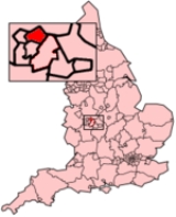
The Metropolitan Borough of Walsall is a local government district in the Black Country part of the West Midlands
, England, with the status of a metropolitan borough
. It is named after its largest settlement, Walsall
, but covers a larger area which also includes the towns of Aldridge
, Brownhills
, Darlaston
, Streetly
and Willenhall
. For Eurostat
purposes Walsall and Wolverhampton is a NUTS 3 region (code UKG35) and is one of five boroughs or unitary districts that comprise the "West Midlands" NUTS 2 region
. The borough had an estimated population of 254,500 in 2007.
The current boundaries were set as part of the provisions of the Local Government Act 1972
, with a change to the north of the borough in 1994. It is bounded on the west by the City of Wolverhampton
, the south by the Metropolitan Borough of Sandwell
, to the south east by the City of Birmingham
, and by the Staffordshire
districts of Lichfield
, Cannock Chase
and South Staffordshire
to the east, north and northwest respectively. Most of the borough is highly industrialised and densely populated, but areas around the north and east of the borough are open space.
In 1986 the borough became an effective unitary authority
when the West Midlands County Council
was abolished. However it remains part of the West Midlands for ceremonial purposes
, and for functions such as policing, fire and public transport.
MP (Labour
). Walsall South is represented by Valerie Vaz
MP (Labour). Aldridge-Brownhills
is represented by Richard Shepherd
MP (Conservative
). The borough is part of the West Midlands
constituency in the European Parliament
. The West Midlands region elects six MEPs, as at 2009 made up of two Conservatives, one from the Labour Party, one Liberal Democrat
, and two members of the United Kingdom Independence Party
.
take place in three out of every four years, with one-third of the seats being contested at each election. Between its formation in 1974 and the 2003 election
, the council varied between control by the Labour Party
, and where no one party had an overall majority. From 2003 to 2011 the Conservative Party
then held a majority of councillors. However at the 2011 election
the Conservative Party lost five seats, while Labour gained eight, and afterwards no party held a majority
.
The Metropolitan Borough of Walsall is based on an amalgamation
of two former local government districts, Walsall County Borough
and Aldridge-Brownhills Urban District.
At the time of the United Kingdom Census 2001
, according to the Office for National Statistics
, the Metropolitan Borough of Walsall had a total resident population of 253,499, of which 123,189 (48.6%) were male and 130,310 (51.4%) were female, with 101,333 households. The Borough occupied 10395 hectares (40.1 sq mi) at the time of the 2001 census.
Its population density was 24.39 people per hectare compared with an average of 28.41 across the West Midlands metropolitan county. The median age of the population was 37, compared with 36 within the West Midlands metropolitan county and 37 across England and Wales.
The majority of the population of the Metropolitan Borough of Walsall were born in England (91.77%); 1.42% were born elsewhere within the United Kingdom
, 0.82% within the rest of the European Union
, and 6.00% elsewhere in the world.
Data on religious beliefs across the borough in the 2001 census show that 72.1% declared themselves to be Christian
, 10.0% said they held no religion, and 5.4% reported themselves as Muslim
.
Within the Metropolitan Borough, 42.84% of households owned a single car or van, with 31.05% owning none. The average car ownership per household was 1.01, compared with 0.96 across the West Midlands metropolitan county.
At the time of the 2001 Census, there were 105,590 people (41.7%) in employment who were resident within Walsall Metropolitan Borough. Of these, 18.60% worked within the wholesale and retail trade, including repair of motor vehicles; 26.44% worked within manufacturing industry; and 9.85% worked within the health and social work sector.
As of the 2001 UK census, Walsall Metropolitan Borough had 180,623 residents aged 16 to 74. 2.3% of these people were students with jobs, 6.0% looking after home or family, 6.8% permanently sick or disabled and 2.4% economically inactive for other reasons. These figures are roughly in line with the averages for England
, though Metropolitan Borough of Walsall has a higher rate of people who are permanently sick and disabled, where the national average is 5.3%.
The Metropolitan Borough of Walsall is split between several Travel to Work Area
s (TTWA). The central and northern areas of the borough (including the towns of Walsall
, Bloxwich
and Brownhills
) are within the Walsall
& Cannock
TTWA, whilst the majority of the area west of the M6 motorway
(including the towns of Willenhall
and Darlaston
) is within the Wolverhampton
TTWA. The southeast of the Metropolitan Borough (including Streetly
) is within the Birmingham
TTWA. The entire borough is within the Birmingham Larger Urban Zone.
Average house prices in the Metropolitan Borough of Walsall were fourth out of the metropolitan boroughs in the West Midlands county
, with the average house price within the borough being £131,131 during the period April - June 2009, compared with the average across the Metropolitan County of £128,142.
to Land's End
by foot or other method.
An elevated section of the M6 Motorway
built in 1968 half circles around Walsall to the West of the town. There can be increased congestion on the local A roads whenever the motorway is temporarily closed or in a state of serious delay as road users try to bypass the problem. Junctions (North to South) 11, 10, 9 and 7 allow access to and from various parts of the town. The M6 and M5 join at junction 8. Local folklore carries the rumour that the Kray Twins disposed of a body within one of the enormous concrete pillars supporting the motorway.
The A454 runs through Walsall on its way to Sutton Coldfield
from Bridgnorth
.
The borough's education format is a traditional 5-7 infant, 7-11 junior and 11-16/18 secondary school system, with some infant and junior schools being combined single site primary schools, while others have infant and junior schools on separate sites. The towns of Walsall, Bloxwich, Darlaston and Willenhall have always used these age ranges, but the Aldridge, Brownhills and Streetly areas (which became part of the Metropolitan Borough of Walsall in 1974) adopted 5-9 first, 9-13 middle and 13-16/18 secondary schools in September 1972. However, this system was discontinued and replaced with the traditional age ranges in September 1986 to fit in with the other schools in the Walsall borough.
West Midlands (county)
The West Midlands is a metropolitan county in western central England with a 2009 estimated population of 2,638,700. It came into existence as a metropolitan county in 1974 after the passage of the Local Government Act 1972, formed from parts of Staffordshire, Worcestershire and Warwickshire. The...
, England, with the status of a metropolitan borough
Metropolitan borough
A metropolitan borough is a type of local government district in England, and is a subdivision of a metropolitan county. Created in 1974 by the Local Government Act 1972, metropolitan boroughs are defined in English law as metropolitan districts, however all of them have been granted or regranted...
. It is named after its largest settlement, Walsall
Walsall
Walsall is a large industrial town in the West Midlands of England. It is located northwest of Birmingham and east of Wolverhampton. Historically a part of Staffordshire, Walsall is a component area of the West Midlands conurbation and part of the Black Country.Walsall is the administrative...
, but covers a larger area which also includes the towns of Aldridge
Aldridge
Aldridge is a town within the Metropolitan Borough of Walsall, in the West Midlands, England. Historically it was part of the county of Staffordshire, but in 1974 it was incorporated into the Walsall borough as well as the West Midlands county.- History :...
, Brownhills
Brownhills
Brownhills is a town in the West Midlands, England. Located on the edge of Cannock Chase near the large artificial lake Chasewater, it is north-east of Walsall and a similar distance south-west of Lichfield. It is part of the Metropolitan Borough of Walsall and the Aldridge-Brownhills...
, Darlaston
Darlaston
Darlaston is a town in the Metropolitan Borough of Walsall in the West Midlands of England.-History:Archaeological evidence of the history of Darlaston has been destroyed by The de Darlaston family owned Darlaston and lived in the manor between the 12th century and 15th century. When the de...
, Streetly
Streetly
Streetly is an area which lies mainly in the Metropolitan Borough of Walsall, England around 8 miles to the north of Birmingham. Streetly lies on the border of Birmingham and Walsall and is part of the West Midlands conurbation. It is adjacent to Aldridge, Sutton Coldfield, Great Barr and Four...
and Willenhall
Willenhall
Willenhall is a town in the Black Country area of the West Midlands of England, with a population of approximately 40,000. It is situated between Wolverhampton and Walsall, historically in the county of Staffordshire...
. For Eurostat
Eurostat
Eurostat is a Directorate-General of the European Commission located in Luxembourg. Its main responsibilities are to provide the European Union with statistical information at European level and to promote the integration of statistical methods across the Member States of the European Union,...
purposes Walsall and Wolverhampton is a NUTS 3 region (code UKG35) and is one of five boroughs or unitary districts that comprise the "West Midlands" NUTS 2 region
NUTS 2 statistical regions of the United Kingdom
In the NUTS codes of the United Kingdom of Great Britain and Northern Ireland , there are 38 level 2 statistical regions.-List of NUTS 2 statistical regions:-See also:* NUTS of the United Kingdom...
. The borough had an estimated population of 254,500 in 2007.
The current boundaries were set as part of the provisions of the Local Government Act 1972
Local Government Act 1972
The Local Government Act 1972 is an Act of Parliament in the United Kingdom that reformed local government in England and Wales on 1 April 1974....
, with a change to the north of the borough in 1994. It is bounded on the west by the City of Wolverhampton
Wolverhampton
Wolverhampton is a city and metropolitan borough in the West Midlands, England. For Eurostat purposes Walsall and Wolverhampton is a NUTS 3 region and is one of five boroughs or unitary districts that comprise the "West Midlands" NUTS 2 region...
, the south by the Metropolitan Borough of Sandwell
Sandwell
Sandwell is a metropolitan borough of the West Midlands with a population of around 289,100, and an area of . The borough is named after Sandwell Priory, and spans a densely populated part of both the Black Country, and the West Midlands conurbation, encompassing the urban towns of Blackheath,...
, to the south east by the City of Birmingham
Birmingham
Birmingham is a city and metropolitan borough in the West Midlands of England. It is the most populous British city outside the capital London, with a population of 1,036,900 , and lies at the heart of the West Midlands conurbation, the second most populous urban area in the United Kingdom with a...
, and by the Staffordshire
Staffordshire
Staffordshire is a landlocked county in the West Midlands region of England. For Eurostat purposes, the county is a NUTS 3 region and is one of four counties or unitary districts that comprise the "Shropshire and Staffordshire" NUTS 2 region. Part of the National Forest lies within its borders...
districts of Lichfield
Lichfield (district)
Lichfield is a local government district in Staffordshire, England. It is administered by Lichfield District Council, based in Lichfield.The dignity and privileges of the City of Lichfield are vested in the parish council of the 14 km² Lichfield civil parish...
, Cannock Chase
Cannock Chase (district)
Cannock Chase is a local government district in England. It covers a large part of Cannock Chase forest and the towns of Cannock, Rugeley and Hednesford.There are several parish and town councils in the district:* Rugeley* Hednesford...
and South Staffordshire
South Staffordshire
South Staffordshire is a local government district in Staffordshire, England. The district lies to the north and west of Wolverhampton and the West Midlands, bordering Shropshire to the west and Worcestershire to the south...
to the east, north and northwest respectively. Most of the borough is highly industrialised and densely populated, but areas around the north and east of the borough are open space.
In 1986 the borough became an effective unitary authority
Unitary authority
A unitary authority is a type of local authority that has a single tier and is responsible for all local government functions within its area or performs additional functions which elsewhere in the relevant country are usually performed by national government or a higher level of sub-national...
when the West Midlands County Council
West Midlands County Council
The West Midlands County Council was, from 1974 to 1986, the upper-tier administrative body for the West Midlands county, a metropolitan county in England....
was abolished. However it remains part of the West Midlands for ceremonial purposes
Ceremonial counties of England
The ceremonial counties are areas of England to which are appointed a Lord Lieutenant, and are defined by the government as counties and areas for the purposes of the Lieutenancies Act 1997 with reference to the metropolitan and non-metropolitan counties of England and Lieutenancies Act 1997...
, and for functions such as policing, fire and public transport.
Parliamentary constituencies
The residents of the Metropolitan Borough of Walsall are represented in the British Parliament by Members of Parliament (MPs) for three separate parliamentary constituencies. Walsall North is represented by David WinnickDavid Winnick
David Julian Winnick is a British Labour Party politician who has been the Member of Parliament for Walsall North since 1979....
MP (Labour
Labour Party (UK)
The Labour Party is a centre-left democratic socialist party in the United Kingdom. It surpassed the Liberal Party in general elections during the early 1920s, forming minority governments under Ramsay MacDonald in 1924 and 1929-1931. The party was in a wartime coalition from 1940 to 1945, after...
). Walsall South is represented by Valerie Vaz
Valerie Vaz
Valerie Carol Marian Vaz is a British politician and lawyer. A member of the Labour Party, she has served as the Member of Parliament for Walsall South since the 2010 general election.-Background:Vaz was born in Aden, Yemen...
MP (Labour). Aldridge-Brownhills
Aldridge-Brownhills (UK Parliament constituency)
Aldridge-Brownhills is a borough constituency represented in the House of Commons of the Parliament of the United Kingdom. It elects one Member of Parliament by the first past the post system of election...
is represented by Richard Shepherd
Richard Shepherd
Richard Charles Scrimgeour Shepherd is a Conservative politician in the United Kingdom. He is currently a Member of Parliament, having represented the constituency of Aldridge-Brownhills since 1979....
MP (Conservative
Conservative Party (UK)
The Conservative Party, formally the Conservative and Unionist Party, is a centre-right political party in the United Kingdom that adheres to the philosophies of conservatism and British unionism. It is the largest political party in the UK, and is currently the largest single party in the House...
). The borough is part of the West Midlands
West Midlands (European Parliament constituency)
West Midlands is a constituency of the European Parliament. For 2009 it elected 6 MEPs using the d'Hondt method of party-list proportional representation. The constituency will also elect a "virtual MEP" who will be able to sit in the Parliament if the Treaty of Lisbon comes into effect...
constituency in the European Parliament
European Parliament
The European Parliament is the directly elected parliamentary institution of the European Union . Together with the Council of the European Union and the Commission, it exercises the legislative function of the EU and it has been described as one of the most powerful legislatures in the world...
. The West Midlands region elects six MEPs, as at 2009 made up of two Conservatives, one from the Labour Party, one Liberal Democrat
Liberal Democrats
The Liberal Democrats are a social liberal political party in the United Kingdom which supports constitutional and electoral reform, progressive taxation, wealth taxation, human rights laws, cultural liberalism, banking reform and civil liberties .The party was formed in 1988 by a merger of the...
, and two members of the United Kingdom Independence Party
United Kingdom Independence Party
The United Kingdom Independence Party is a eurosceptic and right-wing populist political party in the United Kingdom. Whilst its primary goal is the UK's withdrawal from the European Union, the party has expanded beyond its single-issue image to develop a more comprehensive party platform.UKIP...
.
Council
In 1974, Walsall Metropolitan Borough Council was created to administer the newly formed metropolitan borough. Elections to the councilWalsall local elections
One third of Walsall Metropolitan Borough Council in the West Midlands, England is elected each year, followed by one year without election. Since the last boundary changes in 2004, 60 councillors have been elected from 20 wards.-Political control:...
take place in three out of every four years, with one-third of the seats being contested at each election. Between its formation in 1974 and the 2003 election
Walsall Council election, 2003
The 2003 Walsall Council election took place on 1 May 2003 to elect members of Walsall Metropolitan Borough Council in the West Midlands, England...
, the council varied between control by the Labour Party
Labour Party (UK)
The Labour Party is a centre-left democratic socialist party in the United Kingdom. It surpassed the Liberal Party in general elections during the early 1920s, forming minority governments under Ramsay MacDonald in 1924 and 1929-1931. The party was in a wartime coalition from 1940 to 1945, after...
, and where no one party had an overall majority. From 2003 to 2011 the Conservative Party
Conservative Party (UK)
The Conservative Party, formally the Conservative and Unionist Party, is a centre-right political party in the United Kingdom that adheres to the philosophies of conservatism and British unionism. It is the largest political party in the UK, and is currently the largest single party in the House...
then held a majority of councillors. However at the 2011 election
Walsall Council election, 2011
The 2011 Walsall Council election took place on 5 May 2011 to elect members of Walsall Metropolitan Borough Council in the West Midlands, England...
the Conservative Party lost five seats, while Labour gained eight, and afterwards no party held a majority
No overall control
Within the context of local councils of the United Kingdom, the term No Overall Control refers to a situation in which no single party achieves a majority of seats and is analogous to a hung parliament...
.
The Metropolitan Borough of Walsall is based on an amalgamation
Amalgamation (politics)
A merger or amalgamation in a political or administrative sense is the combination of two or more political or administrative entities such as municipalities , counties, districts, etc. into a single entity. This term is used when the process occurs within a sovereign entity...
of two former local government districts, Walsall County Borough
Walsall
Walsall is a large industrial town in the West Midlands of England. It is located northwest of Birmingham and east of Wolverhampton. Historically a part of Staffordshire, Walsall is a component area of the West Midlands conurbation and part of the Black Country.Walsall is the administrative...
and Aldridge-Brownhills Urban District.
Demography
| Walsall MBC Compared | ||||
|---|---|---|---|---|
| 2001 UK Census United Kingdom Census 2001 A nationwide census, known as Census 2001, was conducted in the United Kingdom on Sunday, 29 April 2001. This was the 20th UK Census and recorded a resident population of 58,789,194.... |
Walsall MBC | West Midlands county West Midlands (county) The West Midlands is a metropolitan county in western central England with a 2009 estimated population of 2,638,700. It came into existence as a metropolitan county in 1974 after the passage of the Local Government Act 1972, formed from parts of Staffordshire, Worcestershire and Warwickshire. The... |
England England England is a country that is part of the United Kingdom. It shares land borders with Scotland to the north and Wales to the west; the Irish Sea is to the north west, the Celtic Sea to the south west, with the North Sea to the east and the English Channel to the south separating it from continental... |
|
| Total population | 253,499 | 2,555,592 | 49,138,831 | |
| White | 86.4% | 79.9% | 90.9% | |
| Asian | 10.5% | 13.4% | 4.6% | |
| Black | 1.4% | 3.7% | 2.3% | |
| Source: Office for National Statistics | ||||
At the time of the United Kingdom Census 2001
United Kingdom Census 2001
A nationwide census, known as Census 2001, was conducted in the United Kingdom on Sunday, 29 April 2001. This was the 20th UK Census and recorded a resident population of 58,789,194....
, according to the Office for National Statistics
Office for National Statistics
The Office for National Statistics is the executive office of the UK Statistics Authority, a non-ministerial department which reports directly to the Parliament of the United Kingdom.- Overview :...
, the Metropolitan Borough of Walsall had a total resident population of 253,499, of which 123,189 (48.6%) were male and 130,310 (51.4%) were female, with 101,333 households. The Borough occupied 10395 hectares (40.1 sq mi) at the time of the 2001 census.
Its population density was 24.39 people per hectare compared with an average of 28.41 across the West Midlands metropolitan county. The median age of the population was 37, compared with 36 within the West Midlands metropolitan county and 37 across England and Wales.
The majority of the population of the Metropolitan Borough of Walsall were born in England (91.77%); 1.42% were born elsewhere within the United Kingdom
United Kingdom
The United Kingdom of Great Britain and Northern IrelandIn the United Kingdom and Dependencies, other languages have been officially recognised as legitimate autochthonous languages under the European Charter for Regional or Minority Languages...
, 0.82% within the rest of the European Union
European Union
The European Union is an economic and political union of 27 independent member states which are located primarily in Europe. The EU traces its origins from the European Coal and Steel Community and the European Economic Community , formed by six countries in 1958...
, and 6.00% elsewhere in the world.
Data on religious beliefs across the borough in the 2001 census show that 72.1% declared themselves to be Christian
Christian
A Christian is a person who adheres to Christianity, an Abrahamic, monotheistic religion based on the life and teachings of Jesus of Nazareth as recorded in the Canonical gospels and the letters of the New Testament...
, 10.0% said they held no religion, and 5.4% reported themselves as Muslim
Muslim
A Muslim, also spelled Moslem, is an adherent of Islam, a monotheistic, Abrahamic religion based on the Quran, which Muslims consider the verbatim word of God as revealed to prophet Muhammad. "Muslim" is the Arabic term for "submitter" .Muslims believe that God is one and incomparable...
.
Within the Metropolitan Borough, 42.84% of households owned a single car or van, with 31.05% owning none. The average car ownership per household was 1.01, compared with 0.96 across the West Midlands metropolitan county.
Population change
The table below details the population change in the area since 1801. Although the Metropolitan Borough of Walsall has existed as a metropolitan borough only since 1974, figures have been generated by combining data from the towns, villages, and civil parishes that would later be constituent parts of the borough.| Historical population of area now covered by the Metropolitan Borough of Walsall | |||||||||||
| Year | 1801 | 1811 | 1821 | 1831 | 1841 | 1851 | 1861 | 1871 | 1881 | 1891 | |
|---|---|---|---|---|---|---|---|---|---|---|---|
| Population | 17,615 | 20,329 | 22,309 | 27,640 | 37,670 | 46,597 | 67,260 | 87,923 | 108,586 | 125,317 | |
| Year | 1901 | 1911 | 1921 | 1931 | 1941 | 1951 | 1961 | 1971 | 1981 | 1991 | 2001 |
| Population | 140,919 | 158,465 | 169,406 | 181,114 | 194,983 | 209,918 | 239,729 | 273,794 | 265,908 | 263,399 | 253,502 |
| Source: Vision of Britain | |||||||||||
Economy
| Walsall MBC Compared | ||||
|---|---|---|---|---|
| 2001 UK Census United Kingdom Census 2001 A nationwide census, known as Census 2001, was conducted in the United Kingdom on Sunday, 29 April 2001. This was the 20th UK Census and recorded a resident population of 58,789,194.... |
Walsall MBC | West Midlands county West Midlands (county) The West Midlands is a metropolitan county in western central England with a 2009 estimated population of 2,638,700. It came into existence as a metropolitan county in 1974 after the passage of the Local Government Act 1972, formed from parts of Staffordshire, Worcestershire and Warwickshire. The... |
England England England is a country that is part of the United Kingdom. It shares land borders with Scotland to the north and Wales to the west; the Irish Sea is to the north west, the Celtic Sea to the south west, with the North Sea to the east and the English Channel to the south separating it from continental... |
|
| Population (16-74) | 180,623 | 1,807,918 | 35,532,091 | |
| Full time employment | 39.1% | 38.6% | 40.8% | |
| Part time employment | 11.9% | 11.1% | 11.8% | |
| Self employed | 6.0% | 5.7% | 8.3% | |
| Unemployed | 4.4% | 4.6% | 3.3% | |
| Retired | 14.8% | 13.5% | 13.5% | |
| Source: Office for National Statistics | ||||
At the time of the 2001 Census, there were 105,590 people (41.7%) in employment who were resident within Walsall Metropolitan Borough. Of these, 18.60% worked within the wholesale and retail trade, including repair of motor vehicles; 26.44% worked within manufacturing industry; and 9.85% worked within the health and social work sector.
As of the 2001 UK census, Walsall Metropolitan Borough had 180,623 residents aged 16 to 74. 2.3% of these people were students with jobs, 6.0% looking after home or family, 6.8% permanently sick or disabled and 2.4% economically inactive for other reasons. These figures are roughly in line with the averages for England
England
England is a country that is part of the United Kingdom. It shares land borders with Scotland to the north and Wales to the west; the Irish Sea is to the north west, the Celtic Sea to the south west, with the North Sea to the east and the English Channel to the south separating it from continental...
, though Metropolitan Borough of Walsall has a higher rate of people who are permanently sick and disabled, where the national average is 5.3%.
The Metropolitan Borough of Walsall is split between several Travel to Work Area
Travel to Work Area
A Travel to Work Area or TTWA is a statistical tool used by UK Government agencies and local authorities, especially by the Department for Work and Pensions and Job Centres, to indicate an area where the population would generally commute to a larger town, city or conurbation for the purposes of...
s (TTWA). The central and northern areas of the borough (including the towns of Walsall
Walsall
Walsall is a large industrial town in the West Midlands of England. It is located northwest of Birmingham and east of Wolverhampton. Historically a part of Staffordshire, Walsall is a component area of the West Midlands conurbation and part of the Black Country.Walsall is the administrative...
, Bloxwich
Bloxwich
Bloxwich is a town in the Metropolitan Borough of Walsall, West Midlands, England, with a population of around 40,000 people.-Early history:Bloxwich has its origins at least as early as the Anglo-Saxon period, when the place name evidence suggests it was a small Mercian settlement named after the...
and Brownhills
Brownhills
Brownhills is a town in the West Midlands, England. Located on the edge of Cannock Chase near the large artificial lake Chasewater, it is north-east of Walsall and a similar distance south-west of Lichfield. It is part of the Metropolitan Borough of Walsall and the Aldridge-Brownhills...
) are within the Walsall
Walsall
Walsall is a large industrial town in the West Midlands of England. It is located northwest of Birmingham and east of Wolverhampton. Historically a part of Staffordshire, Walsall is a component area of the West Midlands conurbation and part of the Black Country.Walsall is the administrative...
& Cannock
Cannock
Cannock is the most populous of three towns in the district of Cannock Chase in the central southern part of the county of Staffordshire in the West Midlands region of England....
TTWA, whilst the majority of the area west of the M6 motorway
M6 motorway
The M6 motorway runs from junction 19 of the M1 at the Catthorpe Interchange, near Rugby via Birmingham then heads north, passing Stoke-on-Trent, Manchester, Preston, Carlisle and terminating at the Gretna junction . Here, just short of the Scottish border it becomes the A74 which continues to...
(including the towns of Willenhall
Willenhall
Willenhall is a town in the Black Country area of the West Midlands of England, with a population of approximately 40,000. It is situated between Wolverhampton and Walsall, historically in the county of Staffordshire...
and Darlaston
Darlaston
Darlaston is a town in the Metropolitan Borough of Walsall in the West Midlands of England.-History:Archaeological evidence of the history of Darlaston has been destroyed by The de Darlaston family owned Darlaston and lived in the manor between the 12th century and 15th century. When the de...
) is within the Wolverhampton
Wolverhampton
Wolverhampton is a city and metropolitan borough in the West Midlands, England. For Eurostat purposes Walsall and Wolverhampton is a NUTS 3 region and is one of five boroughs or unitary districts that comprise the "West Midlands" NUTS 2 region...
TTWA. The southeast of the Metropolitan Borough (including Streetly
Streetly
Streetly is an area which lies mainly in the Metropolitan Borough of Walsall, England around 8 miles to the north of Birmingham. Streetly lies on the border of Birmingham and Walsall and is part of the West Midlands conurbation. It is adjacent to Aldridge, Sutton Coldfield, Great Barr and Four...
) is within the Birmingham
Birmingham
Birmingham is a city and metropolitan borough in the West Midlands of England. It is the most populous British city outside the capital London, with a population of 1,036,900 , and lies at the heart of the West Midlands conurbation, the second most populous urban area in the United Kingdom with a...
TTWA. The entire borough is within the Birmingham Larger Urban Zone.
Average house prices in the Metropolitan Borough of Walsall were fourth out of the metropolitan boroughs in the West Midlands county
West Midlands (county)
The West Midlands is a metropolitan county in western central England with a 2009 estimated population of 2,638,700. It came into existence as a metropolitan county in 1974 after the passage of the Local Government Act 1972, formed from parts of Staffordshire, Worcestershire and Warwickshire. The...
, with the average house price within the borough being £131,131 during the period April - June 2009, compared with the average across the Metropolitan County of £128,142.
Transport
The A34 trunk road runs directly through the middle of Walsall and is often used by persons traveling from John o' GroatsJohn o' Groats
John o' Groats is a village in the Highland council area of Scotland. Part of the county of Caithness, John o' Groats is popular with tourists because it is usually regarded as the most northerly settlement of mainland Great Britain, although this is not a claim made by the inhabitants...
to Land's End
Land's End
Land's End is a headland and small settlement in west Cornwall, England, within the United Kingdom. It is located on the Penwith peninsula approximately eight miles west-southwest of Penzance....
by foot or other method.
An elevated section of the M6 Motorway
M6 motorway
The M6 motorway runs from junction 19 of the M1 at the Catthorpe Interchange, near Rugby via Birmingham then heads north, passing Stoke-on-Trent, Manchester, Preston, Carlisle and terminating at the Gretna junction . Here, just short of the Scottish border it becomes the A74 which continues to...
built in 1968 half circles around Walsall to the West of the town. There can be increased congestion on the local A roads whenever the motorway is temporarily closed or in a state of serious delay as road users try to bypass the problem. Junctions (North to South) 11, 10, 9 and 7 allow access to and from various parts of the town. The M6 and M5 join at junction 8. Local folklore carries the rumour that the Kray Twins disposed of a body within one of the enormous concrete pillars supporting the motorway.
The A454 runs through Walsall on its way to Sutton Coldfield
Sutton Coldfield
Sutton Coldfield is a suburb of Birmingham, in the West Midlands of England. Sutton is located about from central Birmingham but has borders with Erdington and Kingstanding. Sutton is in the northeast of Birmingham, with a population of 105,000 recorded in the 2001 census...
from Bridgnorth
Bridgnorth
Bridgnorth is a town in Shropshire, England, along the Severn Valley. It is split into Low Town and High Town, named on account of their elevations relative to the River Severn, which separates the upper town on the right bank from the lower on the left...
.
Education
45% of pupils in the Borough of Walsall achieved five GCSEs with grades of A*-C, below the national average of 56%.The borough's education format is a traditional 5-7 infant, 7-11 junior and 11-16/18 secondary school system, with some infant and junior schools being combined single site primary schools, while others have infant and junior schools on separate sites. The towns of Walsall, Bloxwich, Darlaston and Willenhall have always used these age ranges, but the Aldridge, Brownhills and Streetly areas (which became part of the Metropolitan Borough of Walsall in 1974) adopted 5-9 first, 9-13 middle and 13-16/18 secondary schools in September 1972. However, this system was discontinued and replaced with the traditional age ranges in September 1986 to fit in with the other schools in the Walsall borough.