
Merrimack, New Hampshire
Encyclopedia
Merrimack is a town in Hillsborough County
, New Hampshire
, United States
. The population was 25,494 at the 2010 census, making it the eighth-largest municipality in New Hampshire.
There are four villages in the town: Merrimack Village (formerly known as Souhegan Village), Thornton's Ferry, Reed's Ferry, and South Merrimack.
 Human beings began to settle the area currently known as Merrimack sometime after the recession of the glaciers that had spread over much of New England during the last ice age
. European settlers first came to the area in the late 17th century when the area was still in dispute between the Province of New Hampshire
and Massachusetts Bay Colony
.
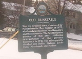
Merrimack was officially incorporated in 1746, a year largely regarded as Merrimack's birthday, although only the southern portion (primarily what is known as Thornton's Ferry) of the current boundaries of town was included in the original town, with the northern portion of what is now Merrimack (primarily what is known as Reed's Ferry) being added a few years later.
The Boston and Maine Railroad
laid tracks through the town in the 19th century, with several stations operating until the mid-20th century when the advent of the automobile transformed Merrimack from a largely agricultural community to a bedroom community of Boston
and nearby cities in New Hampshire
. Since 1970 it has been the home of an Anheuser-Busch
brewery
, their easternmost, and one of their smallest plants in the United States. It is home to a brewery tour and one of the five stables for the Budweiser Clydesdales
.
The Merrimack School Board attracted national attention in 1995 when it passed a "prohibition of alternative lifestyle instruction" act, which resulted in the removal of a work by William Shakespeare
from the school curriculum. The board members who supported the act were voted out in the subsequent board election.
, the town has a total area of 33.4 square miles (86.5 km²), of which 32.6 sq mi (84.4 km²) is land and 0.8 sq mi (2.1 km²) (2.48%) is water. The highest point in Merrimack is an unnamed hill in the northwestern part of town that reaches 512 feet (156.1 m) above sea level
.
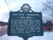
, one of the signers of the Declaration of Independence
who lived in Merrimack and is now buried in a cemetery
near the intersection of Daniel Webster Highway
(U.S. Route 3
) and Greeley Street. Thornton's Ferry Elementary School is located on Camp Sargent Road.
is not traditionally considered a portion of Reed's Ferry. While as a defined village it was located mostly near the Merrimack River
, it may now possibly be seen as part of Reed's Ferry. Reed's Ferry Elementary School is located on Lyons Road.
, Merrimack Village was built along the Souhegan River
that roughly cuts the current town in half. The elementary school in this part of town is named after James Mastricola, who deeded the land to the town upon his death. The lower and upper elementary schools, the middle school, Merrimack High School, the library, and the current town hall, among other buildings, are all located on the land formerly owned by Mastricola.
The "village" is considered to extend westward to the Amherst
border. This is due in large part to the former Town Meetinghouse, which was located on the corner of Turkey Hill Road and Meetinghouse Road.
of 2000, there were 25,119 people, 8,832 households, and 6,986 families residing in the town. The population density
was 770.6 people per square mile (297.5/km²). There were 8,959 housing units at an average density of 274.8 per square mile (106.1/km²). The racial makeup of the town was 96.58% White, 0.73% African American, 0.19% Native American, 1.50% Asian, 0.04% Pacific Islander, 0.21% from other races
, and 0.74% from two or more races. Hispanic or Latino of any race were 1.08% of the population.
There were 8,832 households out of which 41.9% had children under the age of 18 living with them, 68.1% were married couples
living together, 7.8% had a female householder with no husband present, and 20.9% were non-families. 15.8% of all households were made up of individuals and 3.8% had someone living alone who was 65 years of age or older. The average household size was 2.84 and the average family size was 3.19.
In the town the population was spread out with 29.0% under the age of 18, 5.8% from 18 to 24, 34.2% from 25 to 44, 24.7% from 45 to 64, and 6.4% who were 65 years of age or older. The median age was 36 years. For every 100 females there were 99.3 males. For every 100 females age 18 and over, there were 96.7 males.
The median income for a household in the town was $68,817, and the median income for a family was $72,011. Males had a median income of $51,725 versus $31,528 for females. The per capita income
for the town was $27,748. About 1.2% of families and 1.9% of the population were below the poverty line, including 2.9% of those under age 18 and 3.1% of those age 65 or over.
. In addition, there is a charter school
, the Academy for Science and Design
, established for the 2007-08 academic year, which is New Hampshire's first charter school to concentrate on science, math, engineering, and design and is free of tuition fees. Merrimack High School has won one state championship in baseball (2007), three in softball (1980, 1988, 2001), one in football (1987), two in soccer (1998 girls, 2007 boys), three in indoor track (1999, 2007, 2008), four in outdoor track (2003, 2004, 2006, 2007), one in cross-country (2006), one in skiing (1979), one in volleyball (2001), and three in basketball (1967, 2003, 2004).
Four schools in Merrimack, along with 174 others statewide, were listed by the New Hampshire Department of Education as "Schools in Need of Improvement" for the 2008-2009 school year. However, this cloud was lifted in 2009 and Merrimack is no longer declared as a "District in Need of Improvement".
, Manchester
and Nashua
, Merrimack plays a disproportionate role to its size every four years in the New Hampshire primary
; in almost every Fourth of July preceding a presidential election, every presidential candidate will march or have a float in the town's Fourth of July parade.
Traditionally, in state and national politics, the town has been dominated by Republicans, who currently hold seven of the town's eight seats in the General Court
. The current General Court district of Merrimack is Hillsborough
19.
. This form of government was recently adopted by a ballot measure on May 25, 2006. More information on Merrimack's government can be found at Charter commission website.
Each March, the town conducts two deliberative sessions (school and general) to decide what warrant articles will be on the Town General Election ballot in April, one of which is always election of town officers, and another is the budget. If the budget is not approved by the voters, the town's governing council either holds an emergency hearing regarding a new budget or goes forward with the priors years' budget, amended with any time sensitive information pending upon the current year.
The Merrimack Village District administers the water system that serves the central area of the town.
Hillsborough County, New Hampshire
-Demographics:As of the census of 2000, there were 380,841 people, 144,455 households, and 98,807 families residing in the county. The population density was 435 people per square mile . There were 149,961 housing units at an average density of 171 per square mile...
, New Hampshire
New Hampshire
New Hampshire is a state in the New England region of the northeastern United States of America. The state was named after the southern English county of Hampshire. It is bordered by Massachusetts to the south, Vermont to the west, Maine and the Atlantic Ocean to the east, and the Canadian...
, United States
United States
The United States of America is a federal constitutional republic comprising fifty states and a federal district...
. The population was 25,494 at the 2010 census, making it the eighth-largest municipality in New Hampshire.
There are four villages in the town: Merrimack Village (formerly known as Souhegan Village), Thornton's Ferry, Reed's Ferry, and South Merrimack.
History
Ice age
An ice age or, more precisely, glacial age, is a generic geological period of long-term reduction in the temperature of the Earth's surface and atmosphere, resulting in the presence or expansion of continental ice sheets, polar ice sheets and alpine glaciers...
. European settlers first came to the area in the late 17th century when the area was still in dispute between the Province of New Hampshire
Province of New Hampshire
The Province of New Hampshire is a name first given in 1629 to the territory between the Merrimack and Piscataqua rivers on the eastern coast of North America. It was formally organized as an English royal colony on October 7, 1691, during the period of English colonization...
and Massachusetts Bay Colony
Massachusetts Bay Colony
The Massachusetts Bay Colony was an English settlement on the east coast of North America in the 17th century, in New England, situated around the present-day cities of Salem and Boston. The territory administered by the colony included much of present-day central New England, including portions...
.
Merrimack was officially incorporated in 1746, a year largely regarded as Merrimack's birthday, although only the southern portion (primarily what is known as Thornton's Ferry) of the current boundaries of town was included in the original town, with the northern portion of what is now Merrimack (primarily what is known as Reed's Ferry) being added a few years later.
The Boston and Maine Railroad
Boston and Maine Railroad
The Boston and Maine Corporation , known as the Boston and Maine Railroad until 1964, was the dominant railroad of the northern New England region of the United States for a century...
laid tracks through the town in the 19th century, with several stations operating until the mid-20th century when the advent of the automobile transformed Merrimack from a largely agricultural community to a bedroom community of Boston
Boston
Boston is the capital of and largest city in Massachusetts, and is one of the oldest cities in the United States. The largest city in New England, Boston is regarded as the unofficial "Capital of New England" for its economic and cultural impact on the entire New England region. The city proper had...
and nearby cities in New Hampshire
New Hampshire
New Hampshire is a state in the New England region of the northeastern United States of America. The state was named after the southern English county of Hampshire. It is bordered by Massachusetts to the south, Vermont to the west, Maine and the Atlantic Ocean to the east, and the Canadian...
. Since 1970 it has been the home of an Anheuser-Busch
Anheuser-Busch
Anheuser-Busch Companies, Inc. , is an American brewing company. The company operates 12 breweries in the United States and 18 in other countries. It was, until December 2009, also one of America's largest theme park operators; operating ten theme parks across the United States through the...
brewery
Brewery
A brewery is a dedicated building for the making of beer, though beer can be made at home, and has been for much of beer's history. A company which makes beer is called either a brewery or a brewing company....
, their easternmost, and one of their smallest plants in the United States. It is home to a brewery tour and one of the five stables for the Budweiser Clydesdales
Budweiser Clydesdales
The Budweiser Clydesdales are a group of Clydesdale horses used for promotions and commercials by the Anheuser-Busch Brewing Company. There are six "hitches" or teams of horses, five that travel around the United States and one that remains in their official home at the company headquarters at the...
.
The Merrimack School Board attracted national attention in 1995 when it passed a "prohibition of alternative lifestyle instruction" act, which resulted in the removal of a work by William Shakespeare
William Shakespeare
William Shakespeare was an English poet and playwright, widely regarded as the greatest writer in the English language and the world's pre-eminent dramatist. He is often called England's national poet and the "Bard of Avon"...
from the school curriculum. The board members who supported the act were voted out in the subsequent board election.
Notable inhabitants
- Walter KittredgeWalter KittredgeWalter Kittredge , was a famous musician during the American Civil War.Born in Merrimack, New Hampshire, the tenth of eleven children, Kittredge was a talented self-taught musician who played the seraphine, the melodeon , and the violin. Kittredge toured solo and with the Hutchinson Family, a...
, Civil War-era musician - PassaconawayPassaconawayPassaconaway, a name which translates to "Child of the Bear", was a chieftain in the Pennacook tribe.-Life:One of the key native figures in the colonial history of New Hampshire, Passaconaway was believed to have been born between 1550 and 1570, and is said to have died in 1679...
, chieftain in the PennacookPennacookThe Pennacook, also known by the names Merrimack and Pawtucket, were a North American people that primarily inhabited the Merrimack River valley of present-day New Hampshire and Massachusetts, as well as portions of southern Maine...
tribe - Forrest ShermanForrest ShermanForrest Percival Sherman was an admiral in the United States Navy and the youngest man to serve as Chief of Naval Operations until Admiral Elmo Zumwalt became Chief of Naval Operations in 1970....
, admiral in the United States NavyUnited States NavyThe United States Navy is the naval warfare service branch of the United States Armed Forces and one of the seven uniformed services of the United States. The U.S. Navy is the largest in the world; its battle fleet tonnage is greater than that of the next 13 largest navies combined. The U.S...
who served as Chief of Naval OperationsChief of Naval OperationsThe Chief of Naval Operations is a statutory office held by a four-star admiral in the United States Navy, and is the most senior uniformed officer assigned to serve in the Department of the Navy. The office is a military adviser and deputy to the Secretary of the Navy... - Matthew ThorntonMatthew ThorntonMatthew Thornton , was a signer of the United States Declaration of Independence as a representative of New Hampshire.- Background and Early Life :He was born in Ireland, the son of James Thornton and Elizabeth Malone...
, signer of the United States Declaration of IndependenceUnited States Declaration of IndependenceThe Declaration of Independence was a statement adopted by the Continental Congress on July 4, 1776, which announced that the thirteen American colonies then at war with Great Britain regarded themselves as independent states, and no longer a part of the British Empire. John Adams put forth a...
Geography
According to the United States Census BureauUnited States Census Bureau
The United States Census Bureau is the government agency that is responsible for the United States Census. It also gathers other national demographic and economic data...
, the town has a total area of 33.4 square miles (86.5 km²), of which 32.6 sq mi (84.4 km²) is land and 0.8 sq mi (2.1 km²) (2.48%) is water. The highest point in Merrimack is an unnamed hill in the northwestern part of town that reaches 512 feet (156.1 m) above sea level
Sea level
Mean sea level is a measure of the average height of the ocean's surface ; used as a standard in reckoning land elevation...
.
Areas of Merrimack
Shadows of the former villages that now make Merrimack still exist. However, the boundaries and exact definitions are unclear due to the expansion of suburban development in the town during the latter half of the 20th century.Thornton's Ferry
The area of town near Naticook Lake and Continental Boulevard, the name of this area comes from Matthew ThorntonMatthew Thornton
Matthew Thornton , was a signer of the United States Declaration of Independence as a representative of New Hampshire.- Background and Early Life :He was born in Ireland, the son of James Thornton and Elizabeth Malone...
, one of the signers of the Declaration of Independence
Declaration of independence
A declaration of independence is an assertion of the independence of an aspiring state or states. Such places are usually declared from part or all of the territory of another nation or failed nation, or are breakaway territories from within the larger state...
who lived in Merrimack and is now buried in a cemetery
Signer's House and Matthew Thornton Cemetery
Signer's House and Matthew Thornton Cemetery is a historic site in Merrimack, New Hampshire that was home to Matthew Thornton, a signer of the Declaration of Independence....
near the intersection of Daniel Webster Highway
Daniel Webster Highway
Daniel Webster Highway is the name for several sections of U.S. Route 3 in New Hampshire. The highway is named after 19th century statesman Daniel Webster, a New Hampshire native.-Extent:...
(U.S. Route 3
U.S. Route 3
U.S. Route 3 is a north–south United States highway that runs from its southern terminus in Cambridge, Massachusetts through New Hampshire to its terminus near Third Connecticut Lake at the Canadian border, where the road continues north as Quebec Route 257.In New Hampshire parts of US 3 are...
) and Greeley Street. Thornton's Ferry Elementary School is located on Camp Sargent Road.
Reed's Ferry
The northern portion of the town, Reed's Ferry is centered around the current intersection of Bedford Road and Daniel Webster Highway. The boundaries of the area are unclear, as the northwestern part of town near Baboosic LakeBaboosic Lake
Baboosic Lake is a lake located on the border of Amherst and Merrimack, in Hillsborough County, New Hampshire. The lake drains into Baboosic Brook....
is not traditionally considered a portion of Reed's Ferry. While as a defined village it was located mostly near the Merrimack River
Merrimack River
The Merrimack River is a river in the northeastern United States. It rises at the confluence of the Pemigewasset and Winnipesaukee rivers in Franklin, New Hampshire, flows southward into Massachusetts, and then flows northeast until it empties into the Atlantic Ocean at Newburyport...
, it may now possibly be seen as part of Reed's Ferry. Reed's Ferry Elementary School is located on Lyons Road.
South Merrimack
Centered around Pennichuck Square on Rte. 101A and Continental Boulevard, South Merrimack is usually considered to be the southwestern part of town near Rte. 101A and Boston Post Road. However, the southeastern portion of town near Harris Pond might also be considered part of South Merrimack or Thornton's Ferry.Merrimack Village
The center of town is not known as "Merrimack Village" per se, but constitutes the area between the more defined Reed's Ferry and Thornton's Ferry areas. Largely considered to be located at the Public Library on the corner of Baboosic Lake Road and Daniel Webster HighwayDaniel Webster Highway
Daniel Webster Highway is the name for several sections of U.S. Route 3 in New Hampshire. The highway is named after 19th century statesman Daniel Webster, a New Hampshire native.-Extent:...
, Merrimack Village was built along the Souhegan River
Souhegan River
The Souhegan River is a tributary of the Merrimack River in the northeastern United States. long with a drainage area of , it flows north and east through southern New Hampshire to the Merrimack River....
that roughly cuts the current town in half. The elementary school in this part of town is named after James Mastricola, who deeded the land to the town upon his death. The lower and upper elementary schools, the middle school, Merrimack High School, the library, and the current town hall, among other buildings, are all located on the land formerly owned by Mastricola.
The "village" is considered to extend westward to the Amherst
Amherst, New Hampshire
Amherst is a town in Hillsborough County, New Hampshire, United States. The population was 11,201 at the 2010 census. Amherst is home to Ponemah Bog Wildlife Sanctuary, Hodgman State Forest, the Joe English Reservation and Baboosic Lake....
border. This is due in large part to the former Town Meetinghouse, which was located on the corner of Turkey Hill Road and Meetinghouse Road.
Neighboring cities and towns
Demographics
As of the censusCensus
A census is the procedure of systematically acquiring and recording information about the members of a given population. It is a regularly occurring and official count of a particular population. The term is used mostly in connection with national population and housing censuses; other common...
of 2000, there were 25,119 people, 8,832 households, and 6,986 families residing in the town. The population density
Population density
Population density is a measurement of population per unit area or unit volume. It is frequently applied to living organisms, and particularly to humans...
was 770.6 people per square mile (297.5/km²). There were 8,959 housing units at an average density of 274.8 per square mile (106.1/km²). The racial makeup of the town was 96.58% White, 0.73% African American, 0.19% Native American, 1.50% Asian, 0.04% Pacific Islander, 0.21% from other races
Race (United States Census)
Race and ethnicity in the United States Census, as defined by the Federal Office of Management and Budget and the United States Census Bureau, are self-identification data items in which residents choose the race or races with which they most closely identify, and indicate whether or not they are...
, and 0.74% from two or more races. Hispanic or Latino of any race were 1.08% of the population.
There were 8,832 households out of which 41.9% had children under the age of 18 living with them, 68.1% were married couples
Marriage
Marriage is a social union or legal contract between people that creates kinship. It is an institution in which interpersonal relationships, usually intimate and sexual, are acknowledged in a variety of ways, depending on the culture or subculture in which it is found...
living together, 7.8% had a female householder with no husband present, and 20.9% were non-families. 15.8% of all households were made up of individuals and 3.8% had someone living alone who was 65 years of age or older. The average household size was 2.84 and the average family size was 3.19.
In the town the population was spread out with 29.0% under the age of 18, 5.8% from 18 to 24, 34.2% from 25 to 44, 24.7% from 45 to 64, and 6.4% who were 65 years of age or older. The median age was 36 years. For every 100 females there were 99.3 males. For every 100 females age 18 and over, there were 96.7 males.
The median income for a household in the town was $68,817, and the median income for a family was $72,011. Males had a median income of $51,725 versus $31,528 for females. The per capita income
Per capita income
Per capita income or income per person is a measure of mean income within an economic aggregate, such as a country or city. It is calculated by taking a measure of all sources of income in the aggregate and dividing it by the total population...
for the town was $27,748. About 1.2% of families and 1.9% of the population were below the poverty line, including 2.9% of those under age 18 and 3.1% of those age 65 or over.
Education
The six public schools in Merrimack are managed by the Merrimack School District and include Thorntons Ferry Elementary School, Reeds Ferry Elementary School, James Mastricola Elementary School, James Mastricola Upper Elementary School, Merrimack Middle School and Merrimack High SchoolMerrimack High School
Merrimack High School is the public secondary school of the town of Merrimack, New Hampshire. It is located in a central area of town on 38 McElwain Street. About 1,600 students from grades 9 through 12 attend the school each year....
. In addition, there is a charter school
Charter school
Charter schools are primary or secondary schools that receive public money but are not subject to some of the rules, regulations, and statutes that apply to other public schools in exchange for some type of accountability for producing certain results, which are set forth in each school's charter...
, the Academy for Science and Design
Academy for Science and Design
The Academy for Science and Design is a public charter school located in Merrimack, New Hampshire, USA. This is New Hampshire's first charter school to concentrate on science, math, engineering, and design and is free of tuition fees....
, established for the 2007-08 academic year, which is New Hampshire's first charter school to concentrate on science, math, engineering, and design and is free of tuition fees. Merrimack High School has won one state championship in baseball (2007), three in softball (1980, 1988, 2001), one in football (1987), two in soccer (1998 girls, 2007 boys), three in indoor track (1999, 2007, 2008), four in outdoor track (2003, 2004, 2006, 2007), one in cross-country (2006), one in skiing (1979), one in volleyball (2001), and three in basketball (1967, 2003, 2004).
Four schools in Merrimack, along with 174 others statewide, were listed by the New Hampshire Department of Education as "Schools in Need of Improvement" for the 2008-2009 school year. However, this cloud was lifted in 2009 and Merrimack is no longer declared as a "District in Need of Improvement".
State and federal
As a large, suburban community located directly between the state's two largest citiesCity
A city is a relatively large and permanent settlement. Although there is no agreement on how a city is distinguished from a town within general English language meanings, many cities have a particular administrative, legal, or historical status based on local law.For example, in the U.S...
, Manchester
Manchester, New Hampshire
Manchester is the largest city in the U.S. state of New Hampshire, the tenth largest city in New England, and the largest city in northern New England, an area comprising the states of Maine, New Hampshire, and Vermont. It is in Hillsborough County along the banks of the Merrimack River, which...
and Nashua
Nashua, New Hampshire
-Climate:-Demographics:As of the census of 2010, there were 86,494 people, 35,044 households, and 21,876 families residing in the city. The population density was 2,719.9 people per square mile . There were 37,168 housing units at an average density of 1,202.8 per square mile...
, Merrimack plays a disproportionate role to its size every four years in the New Hampshire primary
New Hampshire primary
The New Hampshire primary is the first in a series of nationwide political party primary elections held in the United States every four years , as part of the process of choosing the Democratic and Republican nominees for the presidential elections to be held the subsequent November.Although only a...
; in almost every Fourth of July preceding a presidential election, every presidential candidate will march or have a float in the town's Fourth of July parade.
Traditionally, in state and national politics, the town has been dominated by Republicans, who currently hold seven of the town's eight seats in the General Court
New Hampshire General Court
The General Court of New Hampshire is the bicameral state legislature of the U.S. state of New Hampshire. The lower house is the New Hampshire House of Representatives with 400 members. The upper house is the New Hampshire Senate with 24 members...
. The current General Court district of Merrimack is Hillsborough
Hillsborough County, New Hampshire
-Demographics:As of the census of 2000, there were 380,841 people, 144,455 households, and 98,807 families residing in the county. The population density was 435 people per square mile . There were 149,961 housing units at an average density of 171 per square mile...
19.
Local
The town government consists of a 7-member Town CouncilTown council
A town council is a democratically elected form of government for small municipalities or civil parishes. A council may serve as both the representative and executive branch....
. This form of government was recently adopted by a ballot measure on May 25, 2006. More information on Merrimack's government can be found at Charter commission website.
Each March, the town conducts two deliberative sessions (school and general) to decide what warrant articles will be on the Town General Election ballot in April, one of which is always election of town officers, and another is the budget. If the budget is not approved by the voters, the town's governing council either holds an emergency hearing regarding a new budget or goes forward with the priors years' budget, amended with any time sensitive information pending upon the current year.
The Merrimack Village District administers the water system that serves the central area of the town.