
Melton Hill Dam
Encyclopedia
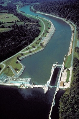
Melton Hill Dam is a hydroelectric dam on the Clinch River
just south of Oak Ridge, Tennessee
, USA. The dam is operated by the Tennessee Valley Authority
, which built the dam in the early 1960s to extend the Tennessee Valley's continuous navigation channel up the Clinch as far as Clinton
and to increase TVA's overall power-generating capacity. The dam impounds the 5470 acres (2,213.6 ha) Melton Hill Lake, and is the only TVA tributary dam serviced by a navigation lock
. Melton Hill Dam was named for Melton Hill, a knob atop nearby Copper Ridge where the U.S. Coast and Geodetic Survey
established a triangulation station
in 1884.
through the hills of northeastern Tennessee before emptying into the Tennessee River
at Kingston
. Melton Hill Dam is located 23 miles (37 km) upstream from the mouth of the Clinch, stretching across the Roane-Loudon county line. Melton Hill's tailwaters are part of Watts Bar Lake
, a main Tennessee River channel impoundment that extends across the lower 23 miles (37 km) of the Clinch. Melton Hill is the newer of two dams on the lower Clinch, the other being Norris Dam
, located 56 miles (90.1 km) upstream from Melton Hill.
capacity of 72 megawatts. The dam is 103 feet (31 m) high and stretches 1,020 feet (311 m) across the Clinch River. The dam is equipped with a 3-bay spillway that has a total discharge of 118,000 cubic feet (3,341 cubic meters) per second.
Melton Hill Lake provides nearly 193 miles (311 km) of shoreline and 5,470 acres (22 km²) of water surface for navigation and recreation, and includes parts of Loudon, Roane, Anderson
, and Knox
counties. The reservoir stretches 56 miles (90.1 km) up the Clinch from the dam to the base of Norris Dam
, and is navigable for 38 miles (61.2 km) from Melton Hill Dam to Clinton.
Melton Hill is the only TVA dam on a tributary stream (i.e., not on the Tennessee River
) with a navigation lock. The lock is 75 feet (22.9 m) x 400 feet (121.9 m), and lowers and raises vessels 60 feet (18.3 m) between Melton Hill Lake and Watts Bar Lake and vice-versa.
 The U.S. Army Corps of Engineers recognized the dam potential of the Melton Hill site as early as the 1920s, and the Tennessee Valley Authority began investigating the site as part of its lower Clinch Valley surveys in the late 1930s. TVA first proposed the Melton Hill project in 1957, and after several years of lobbying, Congress agreed to fund the dam's construction. President Dwight D. Eisenhower
signed the funding bill into law on September 2, 1960, and TVA began building the dam on September 6, 1960.
The construction of Melton Hill Dam and its reservoir required the purchase of 6182 acres (2,501.8 ha) of land, 2182 acres (883 ha) of which— mostly situated along the river's west bank immediately upstream from the dam site— were in possession of the Atomic Energy Commission
. The commission agreed to give this land to TVA in exchange for lands further downstream along Watts Bar Lake. The AEC also agreed to pay for the reconstruction of Oak Ridge's raw water intake after TVA accused them of building it without their approval, in violation of the TVA Act. 89 families and 12.5 miles (20.1 km) of roads were relocated. The project's most problematic relocation issue involved an experimental farm operated by the Agricultural Research Laboratory, a joint initiative of the AEC and the University of Tennessee
. To replace the farm, TVA purchased and paid for the re-seeding of an 886 acres (358.6 ha) plot nearby above reservoir operating levels.
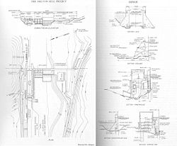
Melton Hill Dam was completed and its gates closed on May 1, 1963. Its first generator went online July 3, 1964, and its second generator went online November 11, 1964. The dam's lock was designed by the Army Corps of Engineers, which based the design on the Corps' Old Hickory Dam
lock in Middle Tennessee. The Melton Hill lock is bigger than the typical 60x360-foot locks used by TVA's Tennessee River dams, allowing Melton Hill to accommodate several barges simultaneously. The lock was placed in service June 10, 1963.
Clinch River
The Clinch River rises in Southwest Virginia near Tazewell, Virginia and flows southwest through the Great Appalachian Valley, gathering various tributaries including the Powell River before joining the Tennessee River in East Tennessee.-Course:...
just south of Oak Ridge, Tennessee
Oak Ridge, Tennessee
Oak Ridge is a city in Anderson and Roane counties in the eastern part of the U.S. state of Tennessee, about west of Knoxville. Oak Ridge's population was 27,387 at the 2000 census...
, USA. The dam is operated by the Tennessee Valley Authority
Tennessee Valley Authority
The Tennessee Valley Authority is a federally owned corporation in the United States created by congressional charter in May 1933 to provide navigation, flood control, electricity generation, fertilizer manufacturing, and economic development in the Tennessee Valley, a region particularly affected...
, which built the dam in the early 1960s to extend the Tennessee Valley's continuous navigation channel up the Clinch as far as Clinton
Clinton, Tennessee
Clinton is a city in Anderson County, Tennessee, United States. Its population was 9,409 at the United States Census, 2000. It is the county seat of Anderson County. Clinton is included in the "Knoxville, Tennessee Metropolitan Statistical Area".-Geography:...
and to increase TVA's overall power-generating capacity. The dam impounds the 5470 acres (2,213.6 ha) Melton Hill Lake, and is the only TVA tributary dam serviced by a navigation lock
Lock (water transport)
A lock is a device for raising and lowering boats between stretches of water of different levels on river and canal waterways. The distinguishing feature of a lock is a fixed chamber in which the water level can be varied; whereas in a caisson lock, a boat lift, or on a canal inclined plane, it is...
. Melton Hill Dam was named for Melton Hill, a knob atop nearby Copper Ridge where the U.S. Coast and Geodetic Survey
U.S. National Geodetic Survey
National Geodetic Survey, formerly called the U.S. Coast and Geodetic Survey , is a United States federal agency that defines and manages a national coordinate system, providing the foundation for transportation and communication; mapping and charting; and a large number of applications of science...
established a triangulation station
Triangulation station
A triangulation station, also known as a triangulation pillar, trigonometrical station, trigonometrical point, trig station, trig beacon or trig point, and sometimes informally as a trig, is a fixed surveying station, used in geodetic surveying and other surveying projects in its vicinity...
in 1884.
Location
The Clinch River flows southwestward for 300 miles (482.8 km) from its source in southwestern VirginiaVirginia
The Commonwealth of Virginia , is a U.S. state on the Atlantic Coast of the Southern United States. Virginia is nicknamed the "Old Dominion" and sometimes the "Mother of Presidents" after the eight U.S. presidents born there...
through the hills of northeastern Tennessee before emptying into the Tennessee River
Tennessee River
The Tennessee River is the largest tributary of the Ohio River. It is approximately 652 miles long and is located in the southeastern United States in the Tennessee Valley. The river was once popularly known as the Cherokee River, among other names...
at Kingston
Kingston, Tennessee
Kingston is a city in and the county seat of Roane County, Tennessee, United States, and is adjacent to Watts Bar Lake. Kingston, with a population of 5,264 at the 2000 United States census, is included in the Harriman, Tennessee Micropolitan Statistical Area....
. Melton Hill Dam is located 23 miles (37 km) upstream from the mouth of the Clinch, stretching across the Roane-Loudon county line. Melton Hill's tailwaters are part of Watts Bar Lake
Watts Bar Lake
Watts Bar Lake is a reservoir on the Tennessee River created by Watts Bar Dam as part of the Tennessee Valley Authority system.-Geography:Located about midway between Chattanooga and Knoxville, the lake begins as the Tennessee River below Fort Loudon Dam in Lenoir City, Tennessee and stretches...
, a main Tennessee River channel impoundment that extends across the lower 23 miles (37 km) of the Clinch. Melton Hill is the newer of two dams on the lower Clinch, the other being Norris Dam
Norris Dam
Norris Dam is a hydroelectric and flood control structure located on the Clinch River in Anderson County and Campbell County, Tennessee, USA. Its construction in the mid-1930s was the first major project for the Tennessee Valley Authority, which had been created in 1933 to bring economic...
, located 56 miles (90.1 km) upstream from Melton Hill.
Capacity
Melton Hill is a concrete gravity-type dam with an electric power generationElectricity generation
Electricity generation is the process of generating electric energy from other forms of energy.The fundamental principles of electricity generation were discovered during the 1820s and early 1830s by the British scientist Michael Faraday...
capacity of 72 megawatts. The dam is 103 feet (31 m) high and stretches 1,020 feet (311 m) across the Clinch River. The dam is equipped with a 3-bay spillway that has a total discharge of 118,000 cubic feet (3,341 cubic meters) per second.
Melton Hill Lake provides nearly 193 miles (311 km) of shoreline and 5,470 acres (22 km²) of water surface for navigation and recreation, and includes parts of Loudon, Roane, Anderson
Anderson County, Tennessee
Anderson County is a U.S. county located in the U.S. state of Tennessee. As of the 2010 census, its population is 75,129. Its county seat is Clinton.It is included in the Knoxville, Tennessee, Metropolitan Statistical Area.-Geography:...
, and Knox
Knox County, Tennessee
Knox County is a county in the U.S. state of Tennessee. Its 2007 population was estimated at 423,874 by the United States Census Bureau. Its county seat is Knoxville, as it has been since the creation of the county. The county is at the geographical center of the Great Valley of East Tennessee...
counties. The reservoir stretches 56 miles (90.1 km) up the Clinch from the dam to the base of Norris Dam
Norris Dam
Norris Dam is a hydroelectric and flood control structure located on the Clinch River in Anderson County and Campbell County, Tennessee, USA. Its construction in the mid-1930s was the first major project for the Tennessee Valley Authority, which had been created in 1933 to bring economic...
, and is navigable for 38 miles (61.2 km) from Melton Hill Dam to Clinton.
Melton Hill is the only TVA dam on a tributary stream (i.e., not on the Tennessee River
Tennessee River
The Tennessee River is the largest tributary of the Ohio River. It is approximately 652 miles long and is located in the southeastern United States in the Tennessee Valley. The river was once popularly known as the Cherokee River, among other names...
) with a navigation lock. The lock is 75 feet (22.9 m) x 400 feet (121.9 m), and lowers and raises vessels 60 feet (18.3 m) between Melton Hill Lake and Watts Bar Lake and vice-versa.
Background and construction
Dwight D. Eisenhower
Dwight David "Ike" Eisenhower was the 34th President of the United States, from 1953 until 1961. He was a five-star general in the United States Army...
signed the funding bill into law on September 2, 1960, and TVA began building the dam on September 6, 1960.
The construction of Melton Hill Dam and its reservoir required the purchase of 6182 acres (2,501.8 ha) of land, 2182 acres (883 ha) of which— mostly situated along the river's west bank immediately upstream from the dam site— were in possession of the Atomic Energy Commission
United States Atomic Energy Commission
The United States Atomic Energy Commission was an agency of the United States government established after World War II by Congress to foster and control the peace time development of atomic science and technology. President Harry S...
. The commission agreed to give this land to TVA in exchange for lands further downstream along Watts Bar Lake. The AEC also agreed to pay for the reconstruction of Oak Ridge's raw water intake after TVA accused them of building it without their approval, in violation of the TVA Act. 89 families and 12.5 miles (20.1 km) of roads were relocated. The project's most problematic relocation issue involved an experimental farm operated by the Agricultural Research Laboratory, a joint initiative of the AEC and the University of Tennessee
University of Tennessee
The University of Tennessee is a public land-grant university headquartered at Knoxville, Tennessee, United States...
. To replace the farm, TVA purchased and paid for the re-seeding of an 886 acres (358.6 ha) plot nearby above reservoir operating levels.
Melton Hill Dam was completed and its gates closed on May 1, 1963. Its first generator went online July 3, 1964, and its second generator went online November 11, 1964. The dam's lock was designed by the Army Corps of Engineers, which based the design on the Corps' Old Hickory Dam
Old Hickory Lock and Dam
Old Hickory Lock and Dam is a dam located in middle Tennessee on the Cumberland River at mile 216.2 in Sumner and Davidson Counties, approximately upstream from Nashville. The reservoir behind the dam is Old Hickory Lake...
lock in Middle Tennessee. The Melton Hill lock is bigger than the typical 60x360-foot locks used by TVA's Tennessee River dams, allowing Melton Hill to accommodate several barges simultaneously. The lock was placed in service June 10, 1963.
External links
- Melton Hill Reservoir — official TVA site
- Pellissippi Blueway