
Megatsunami
Encyclopedia
Tsunami
A tsunami is a series of water waves caused by the displacement of a large volume of a body of water, typically an ocean or a large lake...
that has initial wave height
Wave height
In fluid dynamics, the wave height of a surface wave is the difference between the elevations of a crest and a neighbouring trough. Wave height is a term used by mariners, as well as in coastal, ocean and naval engineering....
s that are much larger than normal tsunamis. Unlike usual tsunamis, which originate from tectonic activity and the raising or lowering of the sea floor, known megatsunamis have originated from large scale landslide
Landslide
A landslide or landslip is a geological phenomenon which includes a wide range of ground movement, such as rockfalls, deep failure of slopes and shallow debris flows, which can occur in offshore, coastal and onshore environments...
s or impact event
Impact event
An impact event is the collision of a large meteorite, asteroid, comet, or other celestial object with the Earth or another planet. Throughout recorded history, hundreds of minor impact events have been reported, with some occurrences causing deaths, injuries, property damage or other significant...
s.
Concept
A megatsunami is meant to refer to a tsunami with an initial waveWave
In physics, a wave is a disturbance that travels through space and time, accompanied by the transfer of energy.Waves travel and the wave motion transfers energy from one point to another, often with no permanent displacement of the particles of the medium—that is, with little or no associated mass...
amplitude
Amplitude
Amplitude is the magnitude of change in the oscillating variable with each oscillation within an oscillating system. For example, sound waves in air are oscillations in atmospheric pressure and their amplitudes are proportional to the change in pressure during one oscillation...
(height
Wave height
In fluid dynamics, the wave height of a surface wave is the difference between the elevations of a crest and a neighbouring trough. Wave height is a term used by mariners, as well as in coastal, ocean and naval engineering....
) measured in several tens, hundreds, or possibly thousands of meters.
Normal tsunamis generated at sea result from movement of the sea floor. They have a small wave height offshore, and a very long wavelength
Wavelength
In physics, the wavelength of a sinusoidal wave is the spatial period of the wave—the distance over which the wave's shape repeats.It is usually determined by considering the distance between consecutive corresponding points of the same phase, such as crests, troughs, or zero crossings, and is a...
(often hundreds of kilometers long), and generally pass unnoticed at sea, forming only a slight swell usually of the order of 30 cm (11.8 in) above the normal sea surface. When they reach land the wave height increases dramatically as the base of the wave pushes the water column above it upwards.
By contrast, megatsunamis are caused by giant landslides and other impact events. Underwater earthquake
Earthquake
An earthquake is the result of a sudden release of energy in the Earth's crust that creates seismic waves. The seismicity, seismism or seismic activity of an area refers to the frequency, type and size of earthquakes experienced over a period of time...
s or volcanic eruptions
Volcanic Eruptions
Volcanic Eruptions is a company owned by Crispin Glover. The company produces and issues Glover's work: It has released two films to date, What Is It? and its sequel, It is Fine! EVERYTHING IS FINE . Its current plans include releasing the final film in the trilogy titled It Is Mine...
do not normally generate such large tsunamis, but landslide
Landslide
A landslide or landslip is a geological phenomenon which includes a wide range of ground movement, such as rockfalls, deep failure of slopes and shallow debris flows, which can occur in offshore, coastal and onshore environments...
s next to bodies of water resulting from earthquakes can, since they cause a massive amount of displacement
Displacement field (mechanics)
A displacement field is an assignment of displacement vectors for all points in a region or body that is displaced from one state to another. A displacement vector specifies the position of a point or a particle in reference to an origin or to a previous position...
. If the landslide or impact occurs in a limited body of water, as happened at the Vajont Dam
Vajont Dam
The Vajont Dam is a disused dam, completed in 1959 in the valley of the Vajont river under Monte Toc, 100 km north of Venice, Italy...
(1963) and Lituya Bay
1958 Lituya Bay megatsunami
The 1958 Lituya Bay megatsunami occurred on July 9, 1958, when an earthquake triggered a landslide that caused 30 million cubic meters of rock and ice to fall into the narrow inlet of Lituya Bay, Alaska...
(1958) then the water may be unable to disperse and one or more exceedingly large waves may result.
Two heights are sometimes quoted for megatsunamis - the height of the wave itself (in water), and the height to which it washes when it reaches land, which depending upon the locale, can be several times larger.
History of the hypothesis
Geologists searching for oil in AlaskaAlaska
Alaska is the largest state in the United States by area. It is situated in the northwest extremity of the North American continent, with Canada to the east, the Arctic Ocean to the north, and the Pacific Ocean to the west and south, with Russia further west across the Bering Strait...
in 1953 observed that in Lituya Bay
Lituya Bay
Lituya Bay is a fjord located on the coast of the Southeast part of the U.S. state of Alaska. It is long and wide at its widest point. The bay was noted in 1786 by Jean-François de La Pérouse, who named it Port des Français...
, mature tree growth did not extend to the shoreline as it did in many other bays in the region. Rather, there was a band of younger trees closer to the shore. Forestry workers, glaciologists, and geographers call the boundary between these bands a trim line
Trim line
A trim line, also written as trimline, is a clear line on the side of a valley formed by a glacier. The line marks the most recent highest extent of the glacier...
. Trees just above the trim line showed severe scarring on their seaward side, whilst those from below the trim line did not. The scientists hypothesized that there had been an unusually large wave or waves in the deep inlet. Because this is a recently deglaciated fjord
Fjord
Geologically, a fjord is a long, narrow inlet with steep sides or cliffs, created in a valley carved by glacial activity.-Formation:A fjord is formed when a glacier cuts a U-shaped valley by abrasion of the surrounding bedrock. Glacial melting is accompanied by rebound of Earth's crust as the ice...
with steep slopes and crossed by a major fault, one possibility was a landslide-generated tsunami.
On 9 July 1958, an earthquake of magnitude 7.7 (on the Richter scale), caused 90 million tonnes of rock and ice to drop into the deep water at the head of Lituya Bay. The block fell almost vertically and hit the water with sufficient force to create a wave
1958 Lituya Bay megatsunami
The 1958 Lituya Bay megatsunami occurred on July 9, 1958, when an earthquake triggered a landslide that caused 30 million cubic meters of rock and ice to fall into the narrow inlet of Lituya Bay, Alaska...
approximately 524 metres (1,719.2 ft) high. Howard Ulrich and his son, Howard Jr., were in the bay in their fishing boat when they saw the wave. They both survived and reported that the wave carried their boat "over the trees" on one of the initial waves which washed them back into the bay, though the larger wave did not harm them much. A similar tsunami out at sea could come tens of kilometers inland.
This event and evidence of a potentially similar past event at the same location inspired the term megatsunami.
Prehistoric
- The asteroidAsteroidAsteroids are a class of small Solar System bodies in orbit around the Sun. They have also been called planetoids, especially the larger ones...
which created the Chicxulub craterChicxulub CraterThe Chicxulub crater is an ancient impact crater buried underneath the Yucatán Peninsula in Mexico. Its center is located near the town of Chicxulub, after which the crater is named...
in YucatanYucatánYucatán officially Estado Libre y Soberano de Yucatán is one of the 31 states which, with the Federal District, comprise the 32 Federal Entities of Mexico. It is divided in 106 municipalities and its capital city is Mérida....
approximately 65 million years ago would have generated megatsunamis as high as 3 kilometres (1.9 mi); enough to completely inundate even large islands such as MadagascarMadagascarThe Republic of Madagascar is an island country located in the Indian Ocean off the southeastern coast of Africa...
. - A series of megatsunami were generated by the bolide impact that created the Chesapeake Bay impact craterChesapeake Bay impact craterThe Chesapeake Bay impact crater was formed by a bolide that impacted the eastern shore of North America about 35 million years ago, in the late Eocene epoch. It is one of the best-preserved "wet-target" or marine impact craters, and the largest known impact crater in the U.S...
, about 35.5 million years ago. - At Seton Portage, British ColumbiaSeton Portage, British ColumbiaSeton Portage is a historic rural community in British Columbia, Canada, that is about 25 km west of Lillooet, located between Seton Lake and Anderson Lake. "The Portage" was formed about 10,000 years ago when the flank of the Cayoosh Range, which is the south flank of the valley, let go and...
, Canada, a freshwater megatsunami may have occurred approximately 10,000 years ago. A huge block of the Cayoosh RangeCayoosh RangeThe Cayoosh Range is the northernmost section of the Lillooet Ranges, which are a subrange of the Pacific Ranges of the Coast Mountains in British Columbia. The range is c...
suddenly slid northwards into what had been a large lake spanning the area from Lillooet, British ColumbiaLillooet, British ColumbiaLillooet is a community on the Fraser River in western Canada, about up the British Columbia Railway line from Vancouver. Situated at an intersection of deep gorges in the lee of the Coast Mountains, it has a dry climate- of precipitation is recorded annually at the town's weather station,...
to near Birken, in the Gates Valley or Pemberton Pass to the southwest. The event has not been studied in detail, but the proto-lake (freshwater fjordFjordGeologically, a fjord is a long, narrow inlet with steep sides or cliffs, created in a valley carved by glacial activity.-Formation:A fjord is formed when a glacier cuts a U-shaped valley by abrasion of the surrounding bedrock. Glacial melting is accompanied by rebound of Earth's crust as the ice...
) may have been at least as deep as the two present-day halves, SetonSeton LakeSeton Lake is a freshwater fjord draining east via the Seton River into the Fraser River at the town of Lillooet, British Columbia, about 22 km long and 243 m in elevation and 26.2 square kilometres in area...
and Anderson Lakes, on either side of the PortageSeton Portage, British ColumbiaSeton Portage is a historic rural community in British Columbia, Canada, that is about 25 km west of Lillooet, located between Seton Lake and Anderson Lake. "The Portage" was formed about 10,000 years ago when the flank of the Cayoosh Range, which is the south flank of the valley, let go and...
, suggesting that the surge generated by the giant landslideLandslideA landslide or landslip is a geological phenomenon which includes a wide range of ground movement, such as rockfalls, deep failure of slopes and shallow debris flows, which can occur in offshore, coastal and onshore environments...
in the narrow mountain confines of the fjordFjordGeologically, a fjord is a long, narrow inlet with steep sides or cliffs, created in a valley carved by glacial activity.-Formation:A fjord is formed when a glacier cuts a U-shaped valley by abrasion of the surrounding bedrock. Glacial melting is accompanied by rebound of Earth's crust as the ice...
valley may have been comparable in scale to Lituya BayLituya BayLituya Bay is a fjord located on the coast of the Southeast part of the U.S. state of Alaska. It is long and wide at its widest point. The bay was noted in 1786 by Jean-François de La Pérouse, who named it Port des Français...
. Another more recent landslide on the south shore of Anderson Lake dropped a large portion of high mountainside down a debris chute, creating a rockwall "fan" which may have made a megatsunami-type wave, though not as large as the main one at the Portage. - Approximately 8,000 years ago, a massive volcanic landslide off of Mt. Etna, SicilySicilySicily is a region of Italy, and is the largest island in the Mediterranean Sea. Along with the surrounding minor islands, it constitutes an autonomous region of Italy, the Regione Autonoma Siciliana Sicily has a rich and unique culture, especially with regard to the arts, music, literature,...
caused a megatsunami which devastated the eastern Mediterranean coastline on three continents. - In the Norwegian SeaNorwegian SeaThe Norwegian Sea is a marginal sea in the North Atlantic Ocean, northwest of Norway. It is located between the North Sea and the Greenland Sea and adjoins the North Atlantic Ocean to the west and the Barents Sea to the northeast. In the southwest, it is separated from the Atlantic Ocean by a...
, the Storegga SlideStoregga SlideThe three Storegga Slides are considered to be amongst the largest known landslides. They occurred under water, at the edge of Norway's continental shelf , in the Norwegian Sea, 100 km north-west of the Møre coast, causing a very large tsunami in the North Atlantic Ocean...
caused a megatsunami approximately 7,000 years ago. - Approximately 6000 years ago, a landslide on RéunionRéunionRéunion is a French island with a population of about 800,000 located in the Indian Ocean, east of Madagascar, about south west of Mauritius, the nearest island.Administratively, Réunion is one of the overseas departments of France...
island, to the east of MadagascarMadagascarThe Republic of Madagascar is an island country located in the Indian Ocean off the southeastern coast of Africa...
, may have caused a megatsunami. - Evidence for large landslides has been found in the form of extensive underwater debris aprons around many volcanic ocean islands which are composed of the material which has slid into the ocean. The island of MolokaiMolokaiMolokai or Molokai is an island in the Hawaiian archipelago. It is 38 by 10 miles in size with a land area of , making it the fifth largest of the main Hawaiian Islands and the 27th largest island in the United States. It lies east of Oahu across the 25-mile wide Kaiwi Channel and north of...
had a catastrophic collapse over a million years ago; this underwater landslide likely caused large tsunamis. In recent years, five such debris aprons have been found around the Hawaiian IslandsHawaiian IslandsThe Hawaiian Islands are an archipelago of eight major islands, several atolls, numerous smaller islets, and undersea seamounts in the North Pacific Ocean, extending some 1,500 miles from the island of Hawaii in the south to northernmost Kure Atoll...
. The Canary IslandsCanary IslandsThe Canary Islands , also known as the Canaries , is a Spanish archipelago located just off the northwest coast of mainland Africa, 100 km west of the border between Morocco and the Western Sahara. The Canaries are a Spanish autonomous community and an outermost region of the European Union...
have at least 14 such debris aprons associated with the archipelagoArchipelagoAn archipelago , sometimes called an island group, is a chain or cluster of islands. The word archipelago is derived from the Greek ἄρχι- – arkhi- and πέλαγος – pélagos through the Italian arcipelago...
.
1792: Mount Unzen, Japan
In 1792, Mount UnzenMount Unzen
is an active volcanic group of several overlapping stratovolcanoes, near the city of Shimabara, Nagasaki Prefecture, on the island of Kyūshū, Japan’s southernmost main island....
in Japan
Japan
Japan is an island nation in East Asia. Located in the Pacific Ocean, it lies to the east of the Sea of Japan, China, North Korea, South Korea and Russia, stretching from the Sea of Okhotsk in the north to the East China Sea and Taiwan in the south...
erupted , causing part of the volcano
Volcano
2. Bedrock3. Conduit 4. Base5. Sill6. Dike7. Layers of ash emitted by the volcano8. Flank| 9. Layers of lava emitted by the volcano10. Throat11. Parasitic cone12. Lava flow13. Vent14. Crater15...
to collapse into the sea. The landslide caused a megatsunami that reached 100 metres (328.1 ft) high and killed 15,000 people in the local fishing villages.
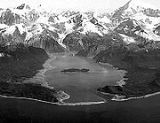
1958: Lituya Bay, Alaska, USA

Lituya Bay
Lituya Bay is a fjord located on the coast of the Southeast part of the U.S. state of Alaska. It is long and wide at its widest point. The bay was noted in 1786 by Jean-François de La Pérouse, who named it Port des Français...
in Alaska, caused by an earthquake, generated a wave with an initial amplitude of 524 metres (1,719.2 ft). This is the highest wave ever recorded, and surged over the headland opposite, stripping trees and soil down to bedrock, and surged along the fjord
Fjord
Geologically, a fjord is a long, narrow inlet with steep sides or cliffs, created in a valley carved by glacial activity.-Formation:A fjord is formed when a glacier cuts a U-shaped valley by abrasion of the surrounding bedrock. Glacial melting is accompanied by rebound of Earth's crust as the ice...
which forms Lituya Bay, destroying a fishing boat anchored there and killing two people. Howard Ulrich and his son managed to ride the wave in their boat, and both survived.
1963: Vajont Dam, Italy
On 9 October 1963, a landslideLandslide
A landslide or landslip is a geological phenomenon which includes a wide range of ground movement, such as rockfalls, deep failure of slopes and shallow debris flows, which can occur in offshore, coastal and onshore environments...
above Vajont Dam
Vajont Dam
The Vajont Dam is a disused dam, completed in 1959 in the valley of the Vajont river under Monte Toc, 100 km north of Venice, Italy...
in Italy
Italy
Italy , officially the Italian Republic languages]] under the European Charter for Regional or Minority Languages. In each of these, Italy's official name is as follows:;;;;;;;;), is a unitary parliamentary republic in South-Central Europe. To the north it borders France, Switzerland, Austria and...
produced a 250 m (820.2 ft) surge that overtopped the dam and destroyed the villages of Longarone
Longarone
Longarone is a town and comune on the banks of the Piave in the province of Belluno, in North-East Italy. It is situated 35 kilometers from Belluno....
, Pirago, Rivalta, Villanova and Faè
FAE
The acronym FAE may refer to:In the arts:* The 'F-A-E' Sonata, jointly written by Robert Schumann, Johannes Brahms, and Albert Dietrich* First Among Equals , a 1984 novel by Jeffrey Archer...
, killing nearly 2,000 people.
1980: Spirit Lake, Washington, USA
On May 18, 1980, the upper 460 meters (1,509 feet) of Mount St. HelensMount St. Helens
Mount St. Helens is an active stratovolcano located in Skamania County, Washington, in the Pacific Northwest region of the United States. It is south of Seattle, Washington and northeast of Portland, Oregon. Mount St. Helens takes its English name from the British diplomat Lord St Helens, a...
failed and detached in a massive landslide
Landslide
A landslide or landslip is a geological phenomenon which includes a wide range of ground movement, such as rockfalls, deep failure of slopes and shallow debris flows, which can occur in offshore, coastal and onshore environments...
. This released the pressure on the magma trapped beneath the summit bulge which exploded as a lateral blast
Lateral eruption
A lateral eruption, also called a flank eruption or lateral blast if explosive, is a volcanic eruption that takes place on the flanks of a volcano instead of at the summit. Lateral eruptions are typical at rift zones where a volcano is breaking apart...
, which then released the over-pressure on the magma chamber and resulted in a plinian eruption
Plinian eruption
Plinian eruptions, also known as 'Vesuvian eruptions', are volcanic eruptions marked by their similarity to the eruption of Mount Vesuvius in AD 79 ....
.
One lobe of the avalanche surged onto Spirit Lake
Spirit Lake (Washington)
Spirit Lake is a lake north of Mount St. Helens in Washington State. The lake was a popular tourist destination for many years until the 1980 eruption of Mount St. Helens. With the eruption and resulting megatsunami, thousands of trees were torn from the surrounding hillside after lake water was...
, causing a megatsunami which pushed the lake waters in a series of surges, which reached a maximum height of 260 meters (853 feet) above the pre-eruption water level (~975 m asl/3,199 ft). Above the upper limit of the tsunami, trees lie where they were knocked down by the pyroclastic surge
Pyroclastic surge
A pyroclastic surge is a fluidized mass of turbulent gas and rock fragments which is ejected during some volcanic eruptions. It is similar to a pyroclastic flow but it has a lower density or contains a much higher proportion of gas to rock ratio, which makes it more turbulent and allows it to rise...
; below the limit, the fallen trees and the surge deposits were removed by the megatsunami and deposited in Spirit Lake.
Potential future megatsunami
Experts interviewed by the BBC think that a massive landslide on a volcanic ocean island is the most likely future cause of a megatsunami. The size and power of a wave generated by such means could produce devastating effects, travelling across oceans and inundating up to 25 kilometres (16 mi) inland from the coast.British Columbia
Some geologists consider an unstable rock face at Mount BreakenridgeMount Breakenridge
Mount Breakenridge, , is a mountain in the Lillooet Ranges of southwestern British Columbia, Canada, located on the east side of upper Harrison Lake in the angle of mountains formed by that lake and the Big Silver River.-Name:...
, above the north end of the giant fresh-water fjord of Harrison Lake
Harrison Lake
Harrison Lake is the largest lake in the southern Coast Mountains of Canada, being about 250 square kilometres in area. It is about 60 km in length and at its widest almost 9 km across. Its southern end, at the resort community of Harrison Hot Springs, is c. 95 km east of...
in the Fraser Valley
Fraser Valley
The Fraser Valley is the section of the Fraser River basin in southwestern British Columbia downstream of the Fraser Canyon. The term is sometimes used to refer to the Fraser Canyon and stretches upstream from there, but in general British Columbian usage of the term refers to the stretch of the...
of southwestern British Columbia
British Columbia
British Columbia is the westernmost of Canada's provinces and is known for its natural beauty, as reflected in its Latin motto, Splendor sine occasu . Its name was chosen by Queen Victoria in 1858...
, Canada, to be unstable enough to collapse into the lake, generating a megatsunami that might destroy the town of Harrison Hot Springs
Harrison Hot Springs, British Columbia
The Village of Harrison Hot Springs is a small community at the southern end of Harrison Lake in the Fraser Valley of British Columbia. It is a member of the Fraser Valley Regional District; its immediate neighbour is the District of Kent and included in it, the town of Agassiz. It is a resort...
(located at its south end).
Canary Islands
Geologists S. Day and S. Ward consider that a megatsunami could be generated during a future eruption involving the Cumbre ViejaCumbre Vieja
Cumbre Vieja is an active volcanic ridge on the volcanic ocean island of Isla de La Palma in the Canary Islands.This ridge trends in an approximate north-south direction and covers the southern third of the island. It is lined by several volcanic craters....
on the volcanic ocean island of La Palma
La Palma
La Palma is the most north-westerly of the Canary Islands. La Palma has an area of 706 km2 making it the fifth largest of the seven main Canary Islands...
, in the Canary Islands
Canary Islands
The Canary Islands , also known as the Canaries , is a Spanish archipelago located just off the northwest coast of mainland Africa, 100 km west of the border between Morocco and the Western Sahara. The Canaries are a Spanish autonomous community and an outermost region of the European Union...
, Spain.
In 1949, the Cumbre Vieja volcano erupted at its Duraznero, Hoyo Negro and San Juan vents. During this eruption, an earthquake with an epicentre near the village of Jedy occurred. The following day Rubio Bonelli, a local geologist, visited the summit area and discovered that a fissure about 2.5 kilometres (1.6 mi) long had opened on the eastern side of the summit. As a result, the western half of the Cumbre Vieja (which is the volcanically active arm of a triple-armed rift) had slipped about 2 metres (6.6 ft) downwards and 1 metres (3.3 ft) westwards towards the Atlantic Ocean
Atlantic Ocean
The Atlantic Ocean is the second-largest of the world's oceanic divisions. With a total area of about , it covers approximately 20% of the Earth's surface and about 26% of its water surface area...
.
The Cumbre Vieja volcano is currently in a dormant stage, but will almost certainly erupt again in the future. Day and Ward hypothesize that if such an eruption causes the western flank to fail, a megatsunami will be generated.
La Palma
La Palma
La Palma is the most north-westerly of the Canary Islands. La Palma has an area of 706 km2 making it the fifth largest of the seven main Canary Islands...
is currently the most volcanically active island in the Canary Islands
Canary Islands
The Canary Islands , also known as the Canaries , is a Spanish archipelago located just off the northwest coast of mainland Africa, 100 km west of the border between Morocco and the Western Sahara. The Canaries are a Spanish autonomous community and an outermost region of the European Union...
Archipelago
Archipelago
An archipelago , sometimes called an island group, is a chain or cluster of islands. The word archipelago is derived from the Greek ἄρχι- – arkhi- and πέλαγος – pélagos through the Italian arcipelago...
. It is likely that several eruptions would be required before failure would occur on Cumbre Vieja. However, the western half of the volcano has an approximate volume of 500 cubic kilometres (120 cu mi) and an estimated mass of 1500000000000 metric tons (1,653,466,966,386.6 ST) If it were to catastrophically slide into the ocean, it could generate a wave with an initial height of about 1000 metres (3,280.8 ft) at the island, and a likely height of around 50 metres (164 ft) at the Caribbean
Caribbean
The Caribbean is a crescent-shaped group of islands more than 2,000 miles long separating the Gulf of Mexico and the Caribbean Sea, to the west and south, from the Atlantic Ocean, to the east and north...
and the Eastern North America
North America
North America is a continent wholly within the Northern Hemisphere and almost wholly within the Western Hemisphere. It is also considered a northern subcontinent of the Americas...
n seaboard when it runs ashore eight or more hours later. Tens of millions of lives would be lost as New York, Boston, Baltimore, Washington, D.C., Miami, Havana, and many other cities near the Atlantic coast are leveled. The likelihood of this happening is a matter of vigorous debate.
The last Cumbre Vieja eruption occurred in 1971 at the southern end of the sub-aerial section without any movement. The section affected by the 1949 eruption is currently stationary and does not appear to have moved since the initial rupture.
Geologists and volcanologist
Volcanologist
A volcanologist is a person who studies the formation of volcanoes, and their current and historic eruptions. Volcanologists frequently visit volcanoes, especially active ones, to observe volcanic eruptions, collect eruptive products including tephra , rock and lava samples...
s also disagree about whether an eruption on the Cumbre Vieja would cause a single large gravitational landslide or a series of smaller landslides.
Hawaii
Prehistoric sedimentary deposits on the Kohala VolcanoKohala (mountain)
Kohala is the oldest of five volcanoes that make up the island of Hawaii. Kohala is an estimated one million years old—so old that it experienced, and recorded, a reversal of magnetic field 780,000 years ago. It is believed to have breached sea level more than 500,000 years ago and to...
, Lanai
Lanai
Lānai or Lanai is the sixth-largest of the Hawaiian Islands. It is also known as the Pineapple Island because of its past as an island-wide pineapple plantation. The only town is Lānai City, a small settlement....
and Molokai
Molokai
Molokai or Molokai is an island in the Hawaiian archipelago. It is 38 by 10 miles in size with a land area of , making it the fifth largest of the main Hawaiian Islands and the 27th largest island in the United States. It lies east of Oahu across the 25-mile wide Kaiwi Channel and north of...
controversially indicates that landslides from the flank of the Kilauea
Kilauea
Kīlauea is a volcano in the Hawaiian Islands, and one of five shield volcanoes that together form the island of Hawaii. Kīlauea means "spewing" or "much spreading" in the Hawaiian language, referring to its frequent outpouring of lava. The Puu Ōō cone has been continuously erupting in the eastern...
and Mauna Loa
Mauna Loa
Mauna Loa is one of five volcanoes that form the Island of Hawaii in the U.S. state of Hawaii in the Pacific Ocean, and the largest on Earth in terms of volume and area covered. It is an active shield volcano, with a volume estimated at approximately , although its peak is about lower than that...
volcanoes in Hawaii
Hawaii
Hawaii is the newest of the 50 U.S. states , and is the only U.S. state made up entirely of islands. It is the northernmost island group in Polynesia, occupying most of an archipelago in the central Pacific Ocean, southwest of the continental United States, southeast of Japan, and northeast of...
may have triggered past megatsunamis, most recently at 120,000 BP
Before Present
Before Present years is a time scale used in archaeology, geology, and other scientific disciplines to specify when events in the past occurred. Because the "present" time changes, standard practice is to use AD 1950 as the origin of the age scale, reflecting the fact that radiocarbon...
. A future tsunami event is also possible, with the tsunami potentially reaching up to about 1 kilometres (3,280.8 ft) in height. According to a documentary called National Geographic's Ultimate Disaster: Tsunami, if a big landslide occurred at Mauna Loa, a 30 metres (98.4 ft) tsunami would take only thirty minutes to reach Honolulu, Hawaii
Honolulu, Hawaii
Honolulu is the capital and the most populous city of the U.S. state of Hawaii. Honolulu is the southernmost major U.S. city. Although the name "Honolulu" refers to the urban area on the southeastern shore of the island of Oahu, the city and county government are consolidated as the City and...
. There, hundreds of thousands of people would be killed as the tsunami leveled Honolulu and traveled 25 kilometres (15.5 mi) inland.
See also
- TsunamiTsunamiA tsunami is a series of water waves caused by the displacement of a large volume of a body of water, typically an ocean or a large lake...
- Historic tsunamisHistoric tsunamisThis article lists notable historic tsunamis, which are sorted by the date and location that the tsunami occurred, the earthquake that generated it, or both....
- La PalmaLa PalmaLa Palma is the most north-westerly of the Canary Islands. La Palma has an area of 706 km2 making it the fifth largest of the seven main Canary Islands...
- Cumbre ViejaCumbre ViejaCumbre Vieja is an active volcanic ridge on the volcanic ocean island of Isla de La Palma in the Canary Islands.This ridge trends in an approximate north-south direction and covers the southern third of the island. It is lined by several volcanic craters....
- Minoan eruption
- 2004 Indian Ocean Earthquake2004 Indian Ocean earthquakeThe 2004 Indian Ocean earthquake was an undersea megathrust earthquake that occurred at 00:58:53 UTC on Sunday, December 26, 2004, with an epicentre off the west coast of Sumatra, Indonesia. The quake itself is known by the scientific community as the Sumatra-Andaman earthquake...
- Tsunamis in lakesTsunamis in lakesA tsunami is defined as a series of water waves caused by the displacement of a large volume of a body of water, such as an ocean. This is misleading as destructive water waves are not restricted to the ocean, in the case of this article the body of water being investigated will be a lake rather...
Further reading
- BBC 2 TV; 2000. Transcript “Mega-tsunami; Wave of Destruction”, Horizon. First screened 21.30 hrs, Thursday, 12 October 2000.
- Rihm, R; Krastel, S. & CD109 Shipboard Scientific Party; 1998. Volcanoes and landslides in the Canaries. National Environment Research Council News. Summer, 16-17.
- Sandom, J.G., 2010, The Wave — A John Decker Thriller, Cornucopia Press, 2010. A thriller in which a megatsunami is intentionally created when a terrorist detonates a nuclear bomb on La Palma in the Canary Islands.
External links
- Mader, Charles L. Mega-Tsunamis Description of the Lituya Bay event.
- World's Biggest Tsunami: The largest recorded tsunami with a wave 1720 feet tall in Lituya Bay, Alaska.
- Benfield Hazard Research Centre
- Science of Tsunami Hazards A more skeptical view from The Tsunami Society.
- BBC — Mega-tsunami: Wave of Destruction BBC Two program broadcast 12 October 2000
- La Palma threat "over-hyped", BBC NewsBBC NewsBBC News is the department of the British Broadcasting Corporation responsible for the gathering and broadcasting of news and current affairs. The department is the world's largest broadcast news organisation and generates about 120 hours of radio and television output each day, as well as online...
, 29 October 2004 - Mega-hyped Tsunami story A detailed of analysis demolishing the La Palma Tsunami speculation.