

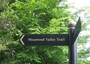
Meanwood Valley Trail
Encyclopedia

Leeds
Leeds is a city and metropolitan borough in West Yorkshire, England. In 2001 Leeds' main urban subdivision had a population of 443,247, while the entire city has a population of 798,800 , making it the 30th-most populous city in the European Union.Leeds is the cultural, financial and commercial...
, West Yorkshire
West Yorkshire
West Yorkshire is a metropolitan county within the Yorkshire and the Humber region of England with a population of 2.2 million. West Yorkshire came into existence as a metropolitan county in 1974 after the passage of the Local Government Act 1972....
, England
England
England is a country that is part of the United Kingdom. It shares land borders with Scotland to the north and Wales to the west; the Irish Sea is to the north west, the Celtic Sea to the south west, with the North Sea to the east and the English Channel to the south separating it from continental...
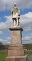
. It runs for a distance of 7 miles (11.3 km) from the statue of (former Leeds mayor) Henry Rowland Marsden
Henry Rowland Marsden
Henry Rowland Marsden was a philanthropist and Mayor of Leeds for 1873 to 1875, said to be the most popular Victorian mayor of Leeds....
, 1878, on Woodhouse Moor
Woodhouse Moor
Woodhouse Moor is an open space approximately one mile from Leeds city centre, West Yorkshire, England. Today it consists of 3 parts: a formal park, Woodhouse Moor , of around 26 hectares in area on the west of Woodhouse Lane , and two other open areas on the east of it...
, close to the University of Leeds
University of Leeds
The University of Leeds is a British Redbrick university located in the city of Leeds, West Yorkshire, England...
, through Headingley
Headingley
Headingley is a suburb of Leeds in West Yorkshire, England. It is approximately two miles out of the city centre, to the north west along the A660 road...
, Meanwood
Meanwood
Meanwood is a suburb and former village of north-west Leeds, West Yorkshire, England.-Origins and History:The name Meanwood goes back to the 12th century, and is of Anglo-Saxon derivation: the Meene wude was the boundary wood of the Manor of Alreton, the woods to the east of Meanwood Beck...
and Adel
Adel, Leeds
Adel is a suburb in North Leeds, West Yorkshire, England. It is situated between Cookridge, Holt Park, Weetwood and Alwoodley. To the north are the villages of Arthington and Bramhope and the market town of Otley...
to Breary Marsh
Breary Marsh
Breary Marsh is a nature reserve and Site of Special Scientific Interest situated adjacent to Golden Acre Park in Leeds, .As the name suggests, it includes an area of marshland, but also a wet alder valley wood. Wooden walkways are provided over marsh area...
, Golden Acre Park
Golden Acre Park
Golden Acre Park is a public park between Adel and Bramhope, Leeds, West Yorkshire, England , administered by Leeds City Council. It is on the A660 Otley Road and covers an area of ....
, where it meets the Leeds Country Way
Leeds Country Way
The Leeds Country Way is a circular long-distance footpath of 62 miles around Leeds, West Yorkshire, England. It is never more than 7 miles from Leeds City Square, but is mainly rural with extensive views in the outlying areas of the Leeds metropolitan district...
. For most of its route (to King Lane) it is the official Leeds link to the Dales Way
Dales Way
The Dales Way is an 84-mile Long Distance Footpath in Northern England, from Ilkley, West Yorkshire to Bowness-on-Windermere, Cumbria....
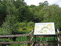
. Along the way are signs giving information about the local wildlife.
The trail is used for an annual trail running
Trail running
Trail running is a variant on running that differs markedly from road running and track running. Trail running generally takes place on hiking trails, most commonly single track trails, although fire roads are not uncommon. A distinguishing characteristic of the trails is that they are often...
race each March/April, organised by local running club the Valley Striders. This race has over 300 participants each year and is part of the Airedale Triple which also includes the Baildon
Baildon (ward)
Baildon is a civil parish and village north of Bradford in Northern England. It is part of the Bradford Metropolitan District in the metropolitan county of West Yorkshire and within the historic boundaries of the West Riding of Yorkshire. It lies north of Bradford and northwest of Leeds city...
Boundary Way and the Guiseley
Guiseley
Guiseley is a small town in the City of Leeds metropolitan borough in West Yorkshire, England. Situated south of Otley and Menston, it is a suburb of north west Leeds. At the 2001 census, Guiseley together with Rawdon had a population of over 21,000. The A65, which passes through the town, is the...
Gallop.
Route
The path is waymarked in both directions and can be started at any point, but is described here Northwards from the Marsden Statue on Woodhouse Moor divided into parts and sections which correspond with the official map leaflet.Stage 1 - Woodhouse Moor to Meanwood Beck
Section 1: At the junction of Woodhouse Lane and Raglan Road, the statue of Henry Marsden is visible 100 m NNW. By this is a map sign (currently vandalised) and an arrow pointing to Raglan Road. Follow Raglan Road north to junction with Rampart Road, turn right, continue over crossroads and head up Delph Lane.Section 2: At the end of Delph Lane turn left on a footpath. You are now on Woodhouse Ridge
Woodhouse Ridge
Woodhouse Ridge is a strip of woodland on the South West hillside of the Meanwood valley in urban area of Leeds, West Yorkshire, England. Locally known as 'the Ridge', the area is notable as a significant area of mature woodland in an otherwise highly developed urban area...
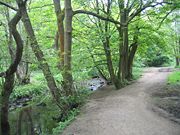
. Follow the top path keeping the stone wall to your left. At a metal gate, go down the steps ahead and bear right on the path until you come to Meanwood Beck
Meanwood Beck
The Meanwood Beck is a stream in West Yorkshire, England, which flows through Adel, Meanwood and Sheepscar into the River Aire in central Leeds. In older texts it was sometimes referred to as the Sheepscar Beck, however that term has fallen out of use....
. Turn left (with the stream on your right) until you leave the Ridge and cross a main road, Grove Lane.
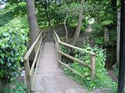
Section 3: The foot path continues behind some back gardens on your left to another road, Monkbridge Road. Cross over turning right, and take the first left, Mill Pond Lane, then take the footpath immediately to the left. After a bridge over Meanwood Beck, turn right for approx 50 metres then turn left, following the path round the millpond, which served the former Meanwood Tannery, now converted to residential flats. The path goes sharp right through some allotments, then reaches housing and just before reaching the road at Hollin Drive turn right to cross Meanwood Beck at a wayymarker post.You pass the disused cricket ground of Highbury CC on your right and turn left on a small bridge over the Beck to enter the picnic area of Meanwood Park.
Stage 2 - Meanwood Park to the Outer Ring Road
Section 5: Keep to the right hand side of Meanwood Beck (though you can cross and re-cross the many little bridges) going upstream and north until you pass through an arch in a stone wall. (If you take the left side of the Beck, there is a big stone arched bridge just before this point.) Turn left across a wooden bridge, then right into woods.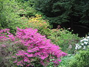
Stage 3 - Ring Road to Stairfoot Lane
Section 7: Turn left and cross the road. Follow it almost to the Ring RoadLeeds Outer Ring Road
The Leeds Outer Ring Road is a main road that runs around most of the perimeter of the city of Leeds, West Yorkshire, England. The ring road is approximately long and consists of single and dual carriageways....
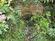
. There is a footpath on the right which eventually runs to a tunnel under the Ring Road. Coming out of this, turn right up some steps and follow the path with the Beck on your right, entering Scotland Woods. Turn right to cross the Beck over a stone bridge. (Note: as an alternative, at the junction to turn right, you could keep left and simply follow the high route until reaching the Seven Arches Aqueduct)
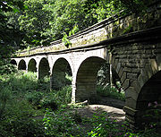
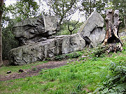
Section 8:Once over the beck turn right for approx 100 metres uphill to reach a wide track and turn left to follow the high path through the woods. Pass under the Seven Arches Aqueduct (built 1840, but disused) and bear right through Adel Woods keeping to the higher path with the beck (now Adel Beck) to your left.
Stage 4 - Stairfoot Lane to Golden Acre Park
Section 10: Cross Stairfoot Lane and join a bridleway opposite the car park, continue along the obvious path as it rises uphill avoiding any deviations to reach a waymarker post indicating bridleway directions. At this point the old gateway is long since missing (and the stile to the right inevitabley unused). Go through the gap and enter the grassy field to follow the field edge on your right to reach a wide, tree/bush lined track (with Headingley Golf Course on your left) to reach King Lane at Golf Farm. Cross the road and turn left following King Lane. Do not walk the main road (it can be very busy), instead take the obvious path that uses the road verge.Section 11: At a junction of 5 roads, carry on ahead (with the narrow woodland briefly on your right), again following the verge path up King Lane. At the next junction a gate ahead across the road leads into Golden Acre Park
Golden Acre Park
Golden Acre Park is a public park between Adel and Bramhope, Leeds, West Yorkshire, England , administered by Leeds City Council. It is on the A660 Otley Road and covers an area of ....
. Follow the path to reach the lake and go either left or right around the lake to reach an underpass which goes under the Otley Road. You will find yourself on raised wooded paths over Breary Marsh
Breary Marsh
Breary Marsh is a nature reserve and Site of Special Scientific Interest situated adjacent to Golden Acre Park in Leeds, .As the name suggests, it includes an area of marshland, but also a wet alder valley wood. Wooden walkways are provided over marsh area...
, and the end of the trail. The Golden Acre car park is immediately adjacent, and the main Otley Road has bus services to Leeds, Otley, Ilkley or Skipton (the latter Mon-Sat). To the north west of the main lake there are toilets & a cafe.
External links
- Meanwood Valley Local Nature Reserve on Leeds City Council website
- Meanwood Valley Trail map (large pdf file) from Leeds City Council website
- Woodhouse Ridge Action Group