
Mattagami River
Encyclopedia
The Mattagami River is a river in the James Bay
drainage basin
in Cochrane District, Timiskaming District and Sudbury District in Northeastern
Ontario
, Canada
.
The Mattagami flows 443 kilometres (275 mi) from its source at Mattagami Lake in geographic Gouin Township in the Unorganized North Part of Sudbury District, on the Canadian Shield
southwest of Timmins
, to Portage Island in geographic Gardiner Township in the Unorganized North Part
of Cochrane District, in the Hudson Bay Lowlands
. Here the Mattagami's confluence with the Missinaibi River
forms the Moose River
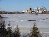
, about 100 kilometres (62.1 mi) from that river's tidewater outlet at James Bay. The Mattagami River flows through the city of Timmins as well as the town of Smooth Rock Falls and its drainage basin encompasses 37000 square kilometres (14,285.8 sq mi).
The Mattagami's name comes from the Ojibwe
and means either "the start of water" (maadaagami) or "turbulent water" (madaagami).
operates the Little Long Generating Station, with a dam just over 5 km in length.
James Bay
James Bay is a large body of water on the southern end of Hudson Bay in Canada. Both bodies of water extend from the Arctic Ocean. James Bay borders the provinces of Quebec and Ontario; islands within the bay are part of Nunavut...
drainage basin
Drainage basin
A drainage basin is an extent or an area of land where surface water from rain and melting snow or ice converges to a single point, usually the exit of the basin, where the waters join another waterbody, such as a river, lake, reservoir, estuary, wetland, sea, or ocean...
in Cochrane District, Timiskaming District and Sudbury District in Northeastern
Northeastern Ontario
Northeastern Ontario is the region within the Canadian province of Ontario which lies north and east of Lakes Superior and Huron.Northeastern Ontario consists of the districts of Algoma, Sudbury, Cochrane, Timiskaming, Nipissing and Manitoulin; and the single-tier municipality of Greater...
Ontario
Ontario
Ontario is a province of Canada, located in east-central Canada. It is Canada's most populous province and second largest in total area. It is home to the nation's most populous city, Toronto, and the nation's capital, Ottawa....
, Canada
Canada
Canada is a North American country consisting of ten provinces and three territories. Located in the northern part of the continent, it extends from the Atlantic Ocean in the east to the Pacific Ocean in the west, and northward into the Arctic Ocean...
.
The Mattagami flows 443 kilometres (275 mi) from its source at Mattagami Lake in geographic Gouin Township in the Unorganized North Part of Sudbury District, on the Canadian Shield
Canadian Shield
The Canadian Shield, also called the Laurentian Plateau, or Bouclier Canadien , is a vast geological shield covered by a thin layer of soil that forms the nucleus of the North American or Laurentia craton. It is an area mostly composed of igneous rock which relates to its long volcanic history...
southwest of Timmins
Timmins
Timmins is a city in northeastern Ontario, Canada on the Mattagami River. At the time of the Canada 2006 Census, Timmins' population was 42,997...
, to Portage Island in geographic Gardiner Township in the Unorganized North Part
Unorganized North Cochrane District
Unorganized Cochrane North Part is an unorganized area in the District of Cochrane in northeastern Ontario, Canada. It comprises all parts of the district north of Timmins and Iroquois Falls which are not part of an incorporated municipality.-Communities:...
of Cochrane District, in the Hudson Bay Lowlands
Hudson Bay Lowlands
The Hudson Bay Lowlands is a large, poorly drained piece of wetlands wedged between the Canadian Shield and southern shores of Hudson Bay and James Bay. Many wide and slow-moving rivers flow through this area toward the salt water of Hudson Bay. Mosquitoes and black flies thrive here. This is a...
. Here the Mattagami's confluence with the Missinaibi River
Missinaibi River
The Missinaibi River is a river in northern Ontario, Canada, which flows northeast from Missinaibi Lake, north of Chapleau, and empties into the Moose River, which drains into James Bay. This river is in length...
forms the Moose River
Moose River (Ontario)
The Moose River is a Canadian river in the Hudson Plains ecozone of northern Ontario which flows 100 km northeast from the junction of the Mattagami and Missinaibi Rivers into James Bay. Its drainage basin is 108,500 km² and it has a mean discharge rate of 1370 m³/s. Its full length...
, about 100 kilometres (62.1 mi) from that river's tidewater outlet at James Bay. The Mattagami River flows through the city of Timmins as well as the town of Smooth Rock Falls and its drainage basin encompasses 37000 square kilometres (14,285.8 sq mi).
The Mattagami's name comes from the Ojibwe
Ojibwe language
Ojibwe , also called Anishinaabemowin, is an indigenous language of the Algonquian language family. Ojibwe is characterized by a series of dialects that have local names and frequently local writing systems...
and means either "the start of water" (maadaagami) or "turbulent water" (madaagami).
Course
For a map showing the river course, see this reference.Economy
Where the Groundhog and Kapuskasing Rivers flow into the Mattagami, Ontario Power GenerationOntario Power Generation
Ontario Power Generation is a public company wholly owned by the Government of Ontario. OPG is responsible for approximately 70% of the electricity generation in the Province of Ontario, Canada. Sources of electricity include nuclear, hydroelectric, solar, wind, and fossil fuel...
operates the Little Long Generating Station, with a dam just over 5 km in length.
Tributaries
Tributaries include the:- Kapuskasing RiverKapuskasing RiverThe Kapuskasing River is a river in the James Bay drainage basin in Cochrane District and Algoma District in northeastern Ontario, Canada. The river is a left tributary of the Mattagami River.-Course:...
- Nemegosenda River
- Chapleau River
- Nemegosenda River
- Groundhog RiverGroundhog RiverThe Groundhog River is a river in Cochrane District and Sudbury District in Northeastern Ontario, Canada. The river is in the James Bay drainage basin and is a left tributary of the Mattagami River.-Course:...
- Ivanhoe RiverIvanhoe RiverThe Ivanhoe River is a river in Cochrane District and Sudbury District in Northeastern Ontario, Canada. The river is in the James Bay drainage basin and is a left tributary of the Groundhog River.-Course:For a map showing the river course, see this reference....
- Nat River
- Ivanhoe River
- Kamiskotia River
- Grassy River
- Tatachikapika River
- Mattagami Lake
- Minisinakwa River
- Nabakwasi River
- Opikinimika River
- Noble River
- Nabakwasi River
- Minisinakwa River