
Matamoras, Pennsylvania
Encyclopedia
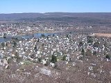
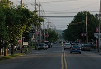
Matamoras is a borough in Pike County
, Pennsylvania
, United States
. The population was 2,469 at the 2010 census. It is the easternmost town in Pennsylvania.
. Its name came from the Mexican town of Matamoros, which was the first to be occupied by U.S. troops during the Mexican-American War. It was incorporated as a borough
on January 18, 1905.
are Port Jervis, New York
and Montague, New Jersey.
According to the United States Census Bureau
, the borough has a total area of 0.8 sq mi. 0.7 sq mi (1.8 km²) of it is land and 0.1 sq mi (0.258998811 km²) of it (11.54%) is water.
of 2010, there were 2,469 people, 955 households, and 665 families residing in the borough. The population density
was 3,527.1/sq mi. There were 1,020 housing units at an average density of 1,457.1 per square mile. The racial makeup of the borough was 93.3% White, 1.4% African American, 0.3% Native American, 1.8% Asian, 0.6% from other races
, and 2.7% from two or more races. Hispanic or Latino of any race were 5.5% of the population.
There were 955 households out of which 33.7% had children under the age of 18 living with them, 48.5% were married couples
living together, 14.6% had a female householder with no husband present, and 30.4% were non-families. 24.9% of all households were made up of individuals and 12.4% had someone living alone who was 65 years of age or older. The average household size was 2.59 and the average family size was 3.09.
In the borough the population was spread out with 26.2% under the age of 18, 57.8% from 18 to 64, and 16% who were 65 years of age or older. The median age was 39 years.
The median income for a household in the borough was $37,361, and the median income for a family was $45,917. Males had a median income of $32,875 versus $26,176 for females. The per capita income
for the borough was $18,946. About 2.4% of families and 4.0% of the population were below the poverty line, including 1.9% of those under age 18 and 7.4% of those age 65 or over.
Pike County, Pennsylvania
-National protected areas:* Delaware Water Gap National Recreation Area * Middle Delaware National Scenic River * Upper Delaware Scenic and Recreational River -Demographics:...
, Pennsylvania
Pennsylvania
The Commonwealth of Pennsylvania is a U.S. state that is located in the Northeastern and Mid-Atlantic regions of the United States. The state borders Delaware and Maryland to the south, West Virginia to the southwest, Ohio to the west, New York and Ontario, Canada, to the north, and New Jersey to...
, United States
United States
The United States of America is a federal constitutional republic comprising fifty states and a federal district...
. The population was 2,469 at the 2010 census. It is the easternmost town in Pennsylvania.
History
Matamoras was originally part of Westfall TownshipWestfall Township, Pennsylvania
Westfall Township is a township in Pike County, Pennsylvania, United States. The population was 2,323 at the 2010 census.-Geography:According to the United States Census Bureau, the township has a total area of 29.4 square miles , of which, 28.8 square miles of it is land and...
. Its name came from the Mexican town of Matamoros, which was the first to be occupied by U.S. troops during the Mexican-American War. It was incorporated as a borough
Borough
A borough is an administrative division in various countries. In principle, the term borough designates a self-governing township although, in practice, official use of the term varies widely....
on January 18, 1905.
Geography
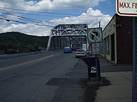
Matamoras is located at 41°22′4"N 74°42′7"W (41.367818, −74.701831). It is the easternmost point in Pennsylvania. Across the Delaware RiverDelaware River
The Delaware River is a major river on the Atlantic coast of the United States.A Dutch expedition led by Henry Hudson in 1609 first mapped the river. The river was christened the South River in the New Netherland colony that followed, in contrast to the North River, as the Hudson River was then...
are Port Jervis, New York
Port Jervis, New York
Port Jervis is a city on the Delaware River in western Orange County, New York, with a population of 8,860 at the 2000 census. The communities of Deerpark, Huguenot, Sparrowbush, and Greenville are adjacent to Port Jervis, and the towns of Montague, New Jersey and Matamoras, Pennsylvania face the...
and Montague, New Jersey.
According to the United States Census Bureau
United States Census Bureau
The United States Census Bureau is the government agency that is responsible for the United States Census. It also gathers other national demographic and economic data...
, the borough has a total area of 0.8 sq mi. 0.7 sq mi (1.8 km²) of it is land and 0.1 sq mi (0.258998811 km²) of it (11.54%) is water.
Demographics
As of the censusCensus
A census is the procedure of systematically acquiring and recording information about the members of a given population. It is a regularly occurring and official count of a particular population. The term is used mostly in connection with national population and housing censuses; other common...
of 2010, there were 2,469 people, 955 households, and 665 families residing in the borough. The population density
Population density
Population density is a measurement of population per unit area or unit volume. It is frequently applied to living organisms, and particularly to humans...
was 3,527.1/sq mi. There were 1,020 housing units at an average density of 1,457.1 per square mile. The racial makeup of the borough was 93.3% White, 1.4% African American, 0.3% Native American, 1.8% Asian, 0.6% from other races
Race (United States Census)
Race and ethnicity in the United States Census, as defined by the Federal Office of Management and Budget and the United States Census Bureau, are self-identification data items in which residents choose the race or races with which they most closely identify, and indicate whether or not they are...
, and 2.7% from two or more races. Hispanic or Latino of any race were 5.5% of the population.
There were 955 households out of which 33.7% had children under the age of 18 living with them, 48.5% were married couples
Marriage
Marriage is a social union or legal contract between people that creates kinship. It is an institution in which interpersonal relationships, usually intimate and sexual, are acknowledged in a variety of ways, depending on the culture or subculture in which it is found...
living together, 14.6% had a female householder with no husband present, and 30.4% were non-families. 24.9% of all households were made up of individuals and 12.4% had someone living alone who was 65 years of age or older. The average household size was 2.59 and the average family size was 3.09.
In the borough the population was spread out with 26.2% under the age of 18, 57.8% from 18 to 64, and 16% who were 65 years of age or older. The median age was 39 years.
The median income for a household in the borough was $37,361, and the median income for a family was $45,917. Males had a median income of $32,875 versus $26,176 for females. The per capita income
Per capita income
Per capita income or income per person is a measure of mean income within an economic aggregate, such as a country or city. It is calculated by taking a measure of all sources of income in the aggregate and dividing it by the total population...
for the borough was $18,946. About 2.4% of families and 4.0% of the population were below the poverty line, including 1.9% of those under age 18 and 7.4% of those age 65 or over.