
Masovian Voivodeship
Encyclopedia
Administrative division
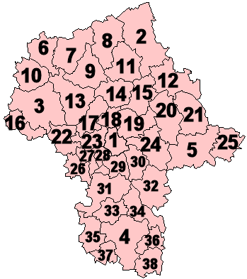
Masovian Voivodeship is divided into 42 counties (powiatPowiat
A powiat is the second-level unit of local government and administration in Poland, equivalent to a county, district or prefecture in other countries. The term powiat is most often translated into English as "county", although other terms are also sometimes used...
s): 5 city counties (miasto na prawach powiatu) and 37 "land counties" (powiat ziemski). These are subdivided into 314 gmina
Gmina
The gmina is the principal unit of administrative division of Poland at its lowest uniform level. It is often translated as "commune" or "municipality." As of 2010 there were 2,479 gminas throughout the country...
s, which include 85 "urban gminas".
The counties, shown on the numbered map, are described in the table below.
 |
|||||||
| Map ref. |
English and Polish names |
Area | Population (2006) |
Seat | Other towns | Total gmina Gmina The gmina is the principal unit of administrative division of Poland at its lowest uniform level. It is often translated as "commune" or "municipality." As of 2010 there were 2,479 gminas throughout the country... s |
|
| (km²) | (sq mi) | ||||||
| City counties | |||||||
| 1 | Warsaw Warsaw Warsaw is the capital and largest city of Poland. It is located on the Vistula River, roughly from the Baltic Sea and from the Carpathian Mountains. Its population in 2010 was estimated at 1,716,855 residents with a greater metropolitan area of 2,631,902 residents, making Warsaw the 10th most... Warszawa |
517 | 200 | 1,700,536 | 1 | ||
| (2) | Ostrołęka | 29 | 11 | 53,758 | 1 | ||
| (3) | Płock | 88 | 34 | 127,307 | 1 | ||
| (4) | Radom Radom Radom is a city in central Poland with 223,397 inhabitants . It is located on the Mleczna River in the Masovian Voivodeship , having previously been the capital of Radom Voivodeship ; 100 km south of Poland's capital, Warsaw.It is home to the biennial Radom Air Show, the largest and... |
112 | 43 | 226,372 | 1 | ||
| (5) | Siedlce Siedlce Siedlce ) is a city in eastern Poland with 77,392 inhabitants . Situated in the Masovian Voivodeship , previously the city was the capital of a separate Siedlce Voivodeship .... |
32 | 12 | 77,047 | 1 | ||
| Land counties | |||||||
| 2 | Ostrołęka County powiat ostrołęcki |
2099 | 810 | 84,344 | Ostrołęka * | Myszyniec Myszyniec Myszyniec is a town in Ostrołęka County, Masovian Voivodeship, Poland, with 3,032 inhabitants .... |
11 |
| 3 | Płock County powiat płocki |
1799 | 695 | 106,455 | Płock * | Gąbin Gabin Gąbin is a small town in Płock County, Masovian Voivodeship, Poland, with 4,230 inhabitants . It is an ancient town, having been founded in the 13th century.-Current events:... , Drobin Drobin Drobin is a town in Płock County, Masovian Voivodeship, Poland, with 3,016 inhabitants .... , Wyszogród Wyszogród Wyszogród is a town in Poland, in Masovian Voivodship, in Płock County, by the Vistula River. The population of Wyszogród was 2,793 in 2004.-History:... |
15 |
| 4 | Radom County Radom County Radom County is a unit of territorial administration and local government in Masovian Voivodeship, east-central Poland. It came into being on January 1, 1999, as a result of the Polish local government reforms passed in 1998. Its administrative seat is the city of Radom, although the city is not... powiat radomski |
1530 | 591 | 145,232 | Radom Radom Radom is a city in central Poland with 223,397 inhabitants . It is located on the Mleczna River in the Masovian Voivodeship , having previously been the capital of Radom Voivodeship ; 100 km south of Poland's capital, Warsaw.It is home to the biennial Radom Air Show, the largest and... * |
Pionki Pionki Pionki is a town in Radom County, Masovian Voivodeship, central Poland with 20 063 inhabitants . Previously it was in Radom Voivodeship and in Kielce Voivodeship .Punk rock band The Bill comes from Pionki... , Iłża, Skaryszew Skaryszew Skaryszew is a town in Radom County, Masovian Voivodeship, Poland, with 3,922 inhabitants .... |
13 |
| 5 | Siedlce County Siedlce County Siedlce County is a unit of territorial administration and local government in Masovian Voivodeship, east-central Poland. It came into being on January 1, 1999, as a result of the Polish local government reforms passed in 1998. Its administrative seat is the city of Siedlce, although the city is... powiat siedlecki |
1603 | 619 | 80,560 | Siedlce Siedlce Siedlce ) is a city in eastern Poland with 77,392 inhabitants . Situated in the Masovian Voivodeship , previously the city was the capital of a separate Siedlce Voivodeship .... * |
Mordy Mordy Mordy is a town in Siedlce County, Masovian Voivodeship, Poland, with 1,831 inhabitants . Its name means Muzzles.... |
13 |
| 6 | Żuromin County Zuromin County Żuromin County is a unit of territorial administration and local government in Masovian Voivodeship, east-central Poland. It came into being on January 1, 1999, as a result of the Polish local government reforms passed in 1998. Its administrative seat and largest town is Żuromin, which lies ... powiat żuromiński |
805 | 311 | 40,078 | Żuromin Zuromin Żuromin is a town in Poland, in Masovian Voivodeship, about 120 km northwest of Warsaw. It is the capital of Żuromin County. Its population is 8,724 .-External links:* *... |
Bieżuń Biezun Bieżuń is a town in Żuromin County, Masovian Voivodeship, Poland, with 1,903 inhabitants on the Wkra River. Jedrzej of Golczew, castellan of Płock, estaqblished the town at the end of the 14th century. Prince Siemowit IV, Duke of Masovia granted the city rights charter in 1406 and in 1869,... |
6 |
| 7 | Mława County powiat mławski |
1182 | 456 | 73,355 | Mława | 10 | |
| 8 | Przasnysz County Przasnysz County Przasnysz County is a unit of territorial administration and local government in Masovian Voivodeship, east-central Poland. It came into being on January 1, 1999, as a result of the Polish local government reforms passed in 1998. Its administrative seat and largest town is Przasnysz, which lies ... powiat przasnyski |
1218 | 470 | 52,948 | Przasnysz Przasnysz Przasnysz is a town in Poland. Located in the Masovian Voivodship, about 110 km north of Warsaw and about 115 km south of Olsztyn, it's the capital of Przasnysz County. It has 18,093 inhabitants . One of the most important towns in Mazovia during the Middle Ages. City laws - 1427.-Famous... |
Chorzele Chorzele Chorzele is a town in Przasnysz County, Masovian Voivodeship, Poland, with 2,799 inhabitants .-External links:*... |
7 |
| 9 | Ciechanów County Ciechanów County Ciechanów County is a unit of territorial administration and local government in Masovian Voivodeship, east-central Poland. It came into being on January 1, 1999, as a result of the Polish local government reforms passed in 1998. Its administrative seat and largest town is Ciechanów, which lies ... powiat ciechanowski |
1063 | 410 | 91,050 | Ciechanów Ciechanów Ciechanów is a town in north-central Poland with 45,900 inhabitants . It is situated in Masovian Voivodeship . It was previously the capital of Ciechanów Voivodeship.-History:The grad numbered approximately 3,000 armed men.... |
Glinojeck Glinojeck Glinojeck is a town in Poland, with 3,087 inhabitants .... |
9 |
| 10 | Sierpc County Sierpc County Sierpc County is a unit of territorial administration and local government in Masovian Voivodeship, east-central Poland. It came into being on January 1, 1999, as a result of the Polish local government reforms passed in 1998. Its administrative seat and only town is Sierpc, which lies ... powiat sierpecki |
853 | 329 | 53,811 | Sierpc Sierpc Sierpc is a town in Poland, in the north-west part of the Masovian Voivodeship, about 125 km northwest of Warsaw. It is the capital of Sierpc County. Its population is 18,777 . It is located near the national road No 10, which connects Warsaw and Toruń... |
7 | |
| 11 | Maków County Maków County Maków County is a unit of territorial administration and local government in Masovian Voivodeship, east-central Poland. It came into being on January 1, 1999, as a result of the Polish local government reforms passed in 1998. Its administrative seat and largest town is Maków Mazowiecki, which... powiat makowski |
1065 | 411 | 46,474 | Maków Mazowiecki Maków Mazowiecki Maków Mazowiecki is a town in Poland, in the Masovian Voivodship. It is the powiat capital of Maków County . Its population is 10,850.... |
Różan Rózan Różan is a town in Mazovian Voivodeship, Poland. It is located at around . Narew River flows through the town.... |
10 |
| 12 | Ostrów Mazowiecka County Ostrów Mazowiecka County Ostrów Mazowiecka County is a unit of territorial administration and local government in Masovian Voivodeship, east-central Poland. It came into being on January 1, 1999, as a result of the Polish local government reforms passed in 1998. Its administrative seat and largest town is Ostrów... powiat ostrowski |
1218 | 470 | 75,073 | Ostrów Mazowiecka Ostrów Mazowiecka Ostrów Mazowiecka is a town in northeastern Poland with 23,486 inhabitants . Situated in the Masovian Voivodeship , previously in Ostroleka Voivodeship . It is the capital of Ostrów Mazowiecka County.... |
Brok Brok Brok is a town in Ostrów Mazowiecka County, Masovian Voivodeship, Poland, with 1,882 inhabitants .-External links:*... |
11 |
| 13 | Płońsk County powiat płoński |
1384 | 534 | 87,430 | Płońsk | Raciąż Raciaz Raciąż is a town in Płońsk County, Masovian Voivodeship, Poland, with 4,585 inhabitants . Its history dates to 10th century.... |
12 |
| 14 | Pułtusk County powiat pułtuski |
829 | 320 | 51,033 | Pułtusk | 7 | |
| 15 | Wyszków County Wyszków County Wyszków County is a unit of territorial administration and local government in Masovian Voivodeship, east-central Poland. It originally existed from 1956 until the abolition of the powiats in 1975, but was re-created on January 1, 1999, as a result of the Polish local government reforms passed in... powiat wyszkowski |
876 | 338 | 71,558 | Wyszków Wyszków Wyszków is a town in northeastern Poland with 26,500 inhabitants . It is the capital of Wyszków County . Wyszków is situated in the Masovian Voivodeship ; previously it was in Warsaw Voivodeship and Ostrołęka Voivodeship .-Description:The village of Wyszków was first documented in 1203. The town... |
6 | |
| 16 | Gostynin County Gostynin County Gostynin County is a unit of territorial administration and local government in Masovian Voivodeship, east-central Poland. It came into being on January 1, 1999, as a result of the Polish local government reforms passed in 1998. Its administrative seat and only town is Gostynin, which lies west... powiat gostyniński |
616 | 238 | 47,034 | Gostynin Gostynin Gostynin is a town in Central Poland with 19,414 inhabitants . It is situated in the Masovian Voivodship since 1999 and was previously in the Płock Voivodship from 1975 to 1998. It is the capital of Gostynin County.-External links:*... |
5 | |
| 17 | Nowy Dwór Mazowiecki County Nowy Dwór Mazowiecki County Nowy Dwór Mazowiecki County is a unit of territorial administration and local government in Masovian Voivodeship, east-central Poland. It came into being on January 1, 1999, as a result of the Polish local government reforms passed in 1998. Its administrative seat and largest town is Nowy Dwór... powiat nowodworski |
692 | 267 | 75,736 | Nowy Dwór Mazowiecki Nowy Dwór Mazowiecki Nowy Dwór Mazowiecki is a town in central Poland with ca. 42500 inhabitants . It is situated in the Masovian Voivodeship ; previously, it was in Warszawa Voivodeship... |
Nasielsk Nasielsk Nasielsk is a small town in Masovian Voivodeship, Poland. It is located on a major Warsaw-Gdańsk rail line and serves as a junction, with an additional connection to Sierpc.... , Zakroczym Zakroczym Zakroczym is a small town in the Masovian Voivodeship, Poland. It is located at around . The Vistula River flows through the town.... |
6 |
| 18 | Legionowo County Legionowo County Legionowo County is a unit of territorial administration and local government in Masovian Voivodeship, east-central Poland. It came into being on January 1, 1999, as a result of the Polish local government reforms passed in 1998. Its administrative seat and largest town is Legionowo, which lies ... powiat legionowski |
390 | 151 | 96,497 | Legionowo Legionowo Legionowo is a town in Masovia . According to the 2004 Census estimate the town has a total population of 50,759.Legionowo is located ca. 23 km to the north-east of the center of Warsaw and only 7 km to the south of Zegrze Reservoir , near the Warsaw-Gdańsk railroad and Warsaw-Suwałki... |
Serock Serock Serock is a town at the north bank of the Zegrze lake in the Legionowo County, Masovian Voivodeship, Poland, with 3,616 inhabitants .... |
5 |
| 19 | Wołomin County powiat wołomiński |
955 | 369 | 202,444 | Wołomin | Ząbki Zabki Ząbki is a town in central Poland with 23,277 inhabitants . It is situated in the Masovian Voivodeship, bordering Warsaw from the north-east. Its name means Toothies or Teeth.- History :... , Marki Marki Marki is a town in central Poland, just to the north-east of the Polish capital Warsaw.Marki, a Warsaw suburb, was incorporated in 1967. While by Polish standards Marki is a relatively young town, with approximately 23,000 residents, it is one of the fastest growing cities in the Masovian... , Kobyłka, Zielonka Zielonka Zielonka is a town in Wołomin County, Masovian Voivodeship, Poland, with 17,075 inhabitants . It is located about 13 km to the north-east of the centre of Warsaw.City rights since 1960.-Objects:3 primary schoolsa junior high school... , Radzymin Radzymin Radzymin is a town in Poland and is one of the distant suburbs of the city of Warsaw. It is located in the powiat of Wołomin of the Masovian Voivodeship. The town has 8,818 inhabitants .Radzymin was located by Bolesław IV of Warsaw in 1440... , Tłuszcz |
12 |
| 20 | Węgrów County Wegrów County Węgrów County is a unit of territorial administration and local government in Masovian Voivodeship, east-central Poland. It came into being on January 1, 1999, as a result of the Polish local government reforms passed in 1998. Its administrative seat and largest town is Węgrów, which lies east... powiat węgrowski |
1219 | 471 | 67,823 | Węgrów Wegrów Węgrów is a town in eastern Poland with 12,561 inhabitants . Situated in the Masovian Voivodeship , it is the capital of Węgrów County.First mentioned in historical records in 1414, it received its citycharter in 1441... |
Łochów | 9 |
| 21 | Sokołów County powiat sokołowski |
1131 | 437 | 56,823 | Sokołów Podlaski | Kosów Lacki Kosów Lacki Kosów Lacki is a town in Sokołów County, Masovian Voivodeship, Poland, with 2,152 inhabitants .-History:*1202 - First mention of a village Kossów found in documents belonging to prince Konrad Mazowiecki.... |
9 |
| 22 | Sochaczew County Sochaczew County Sochaczew County is a unit of territorial administration and local government in Masovian Voivodeship, east-central Poland. It came into being on January 1, 1999, as a result of the Polish local government reforms passed in 1998. Its administrative seat and only town is Sochaczew, which lies ... powiat sochaczewski |
731 | 282 | 83,318 | Sochaczew Sochaczew Sochaczew is a town in central Poland, with 38,300 inhabitants . Situated in the Masovian Voivodeship , previously in Skierniewice Voivodeship . It is the capital of Sochaczew County.... |
8 | |
| 23 | Warsaw West County Warsaw West County Warsaw West County is a unit of territorial administration and local government in Masovian Voivodeship, east-central Poland. It came into being on January 1, 1999, as a result of the Polish local government reforms passed in 1998... powiat warszawski zachodni |
533 | 206 | 100,965 | Ożarów Mazowiecki Ozarów Mazowiecki Ożarów Mazowiecki is a town in Poland, just to the west of Warsaw, in Mazowsze Voivodship.It is the capital of Warsaw West County . Its population numbers 8,227 .-External links:*... |
Łomianki, Błonie | 7 |
| 24 | Mińsk County Minsk County Mińsk County is a unit of territorial administration and local government in Masovian Voivodeship, east-central Poland. It was created on January 1, 1999, as a result of the Polish local government reforms passed in 1998. Its administrative seat and largest town is Mińsk Mazowiecki, which lies ... powiat miński |
1164 | 449 | 141,048 | Mińsk Mazowiecki Minsk Mazowiecki Mińsk Mazowiecki is a town in central Poland with 38 181 inhabitants . It is situated in the Masovian Voivodeship , previously in Siedlce Voivodeship... |
Sulejówek Sulejówek Sulejówek is a town in Poland, about 18 km east of Warsaw city centre and part of its metropolitan area. It is located in Masovian Voivodeship, in Mińsk County... , Halinów Halinów Halinów is a town in Mińsk County, Masovian Voivodeship, Poland, with 3,369 inhabitants .Halinów – miasto we wschodniej Polsce, w woj. mazowieckim, w powiecie mińskim, siedziba gminy miejsko-wiejskiej Halinów, położone nad rzeką Długą. W latach 1975–1998 miasto administracyjnie należało do woj.... , Kałuszyn |
13 |
| 25 | Łosice County powiat łosicki |
772 | 298 | 32,769 | Łosice | 6 | |
| 26 | Żyrardów County Zyrardów County Żyrardów County is a unit of territorial administration and local government in Masovian Voivodeship, east-central Poland. It came into being on January 1, 1999, as a result of the Polish local government reforms passed in 1998. Its administrative seat and largest town is Żyrardów, which lies ... powiat żyrardowski |
533 | 206 | 74,662 | Żyrardów Zyrardów Żyrardów is a town in central Poland with 41,400 inhabitants . It is situated in the Masovian Voivodship ; previously, it was in Skierniewice Voivodship 45 km West of Warsaw. It is the capital of Żyrardów County... |
Mszczonów Mszczonów Mszczonów is a town in Żyrardów County, Masovian Voivodeship, Poland, with 6,310 inhabitants .The town had a Jewish community, and it was once the center of the Hasidic Amshinov dynasty... |
5 |
| 27 | Grodzisk Mazowiecki County Grodzisk Mazowiecki County Grodzisk Mazowiecki County is a unit of territorial administration and local government in Masovian Voivodeship, east-central Poland. It came into being on January 1, 1999, as a result of the Polish local government reforms passed in 1998. Its administrative seat and largest town is Grodzisk... powiat grodziski |
367 | 142 | 78,208 | Grodzisk Mazowiecki Grodzisk Mazowiecki Grodzisk Mazowiecki is a town in central Poland with 26,881 inhabitants in 2006. It is 30 km. southwest of Warsaw.Between 1975 and 1998 it was situated in the Warszawa Voivodeship but since 1999 it has been situated in the Masovian Voivodeship. It is the capital of Grodzisk Mazowiecki... |
Milanówek Milanówek Milanówek is a town and a seat of a separate commune in Poland. Located in the Grodzisk Mazowiecki County near Warsaw, it is often considered an outlying suburb of the capital of Poland but is in fact an independent entity administratively and culturally. Milanówek is however part of wider Warsaw... , Podkowa Leśna Podkowa Lesna Podkowa Leśna is a town in Grodzisk Mazowiecki County of Poland and located on the Łowicko–Błońska Plain within the territory of the Młochowskie Forests. City status - from January 1, 1969. The city also has the status of gmina, meaning "commune"... |
6 |
| 28 | Pruszków County Pruszków County Pruszków County is a unit of territorial administration and local government in Masovian Voivodeship, east-central Poland. It came into being on January 1, 1999, as a result of the Polish local government reforms passed in 1998. Its administrative seat and largest town is Pruszków, which lies ... powiat pruszkowski |
246 | 95 | 145,870 | Pruszków Pruszków Pruszków is a town in central Poland, situated in the Masovian Voivodeship since 1999. It was previously in Warszawa Voivodeship . Pruszków is the capital of Pruszków County, located along the western edge of the Warsaw urban area... |
Piastów Piastów Piastów is a town in central Poland, near Warsaw, with 23,331 inhabitants . It is situated in the Masovian Voivodship ; previously, it was in Warszawa Voivodship... , Brwinów Brwinów Brwinów is a town in Pruszków County, Masovian Voivodeship, Poland, about 25 km from the centre of Warsaw; according to the 2008 records Brwinów has 12131 inhabitants.... |
6 |
| 29 | Piaseczno County Piaseczno County Piaseczno County is a unit of territorial administration and local government in Masovian Voivodeship, east-central Poland. It came into being on January 1, 1999, as a result of the Polish local government reforms passed in 1998. Its administrative seat and largest town is Piaseczno, which lies ... powiat piaseczyński |
621 | 240 | 145,276 | Piaseczno Piaseczno Piaseczno is a town in central Poland with 32,610 inhabitants .It is situated in the Masovian Voivodeship, approximately 16 kilometers south of Warsaw. It is a popular residential area and a suburb of Warsaw and is strongly linked to the capital, both economically and culturally... |
Konstancin-Jeziorna Konstancin-Jeziorna Konstancin-Jeziorna is a town in Piaseczno County, Masovian Voivodeship, Poland, with 16,963 inhabitants . It is located about 20 km south of downtown Warsaw and is a part of the metropolitan area of that city.... , Góra Kalwaria Góra Kalwaria Góra Kalwaria is a town on the Vistula River in the Mazovian Voivodship, Poland, about 25 km southeast of Warsaw. It has a population of about 11,000 . The town has significance for both Catholic Christians and Hasidic Jews... , Tarczyn Tarczyn Tarczyn is a town in Poland, located in Masovian Voivodeship, about 30 km south of Warsaw. There were 3,869 inhabitants living there in 2004... |
6 |
| 30 | Otwock County Otwock County Otwock County is a unit of territorial administration and local government in Masovian Voivodeship, east-central Poland. It came into being on January 1, 1999, as a result of the Polish local government reforms passed in 1998. Its administrative seat and largest town is Otwock, which lies ... powiat otwocki |
615 | 237 | 116,086 | Otwock Otwock Otwock is a town in central Poland, some southeast of Warsaw, with 42,765 inhabitants . It is situated on the right bank of Vistula River below the mouth of Swider River. Otwock is home to a unique architectural style called Swidermajer.... |
Józefów Józefów Józefów is a very common placename in Poland.Towns:* Józefów in Masovian Voivodeship, near Warsaw*Józefów, Biłgoraj County in Lublin Voivodeship Villages:... , Karczew Karczew Karczew is a town in Otwock County, Masovian Voivodeship, Poland, with 10,271 inhabitants .-References:... |
8 |
| 31 | Grójec County Grójec County Grójec County is a unit of territorial administration and local government in Masovian Voivodeship, east-central Poland. It came into being on January 1, 1999, as a result of the Polish local government reforms passed in 1998. Its administrative seat and largest town is Grójec, which lies south... powiat grójecki |
1269 | 490 | 96,489 | Grójec Grójec Grójec is a town in Poland. Located in the Masovian Voivodeship, about 40 km south of Warsaw, it is the capital of Grójec County. It has about 14,875 inhabitants . Grójec surroundings are considered to be the biggest apple-growing area of Poland. It is said, that the region makes up also for... |
Warka Warka Warka is a town in central Poland, located on the left bank of the Pilica river , with 11,035 inhabitants . It has been situated in Grójec County, in the Masovian Voivodeship, since 1999; previously it was in the Radom Voivodeship from 1975 to 1998.Warka obtained its city charter in 1321... , Nowe Miasto nad Pilicą Nowe Miasto nad Pilica Nowe Miasto nad Pilicą is a town in Grójec County, Masovian Voivodeship, Poland, with 3,885 inhabitants .... , Mogielnica Mogielnica Mogielnica is a town in Grójec County in Masovian Voivodeship, Poland, with 2,475 inhabitants . It is a seat of Gmina Mogielnica with an area of 141.56 square kilometres .-Modern history:... |
10 |
| 32 | Garwolin County Garwolin County Garwolin County is a unit of territorial administration and local government in Masovian Voivodeship, east-central Poland. It came into being on January 1, 1999, as a result of the Polish local government reforms passed in 1998. Its administrative seat and largest town is Garwolin, which lies ... powiat garwoliński |
1284 | 496 | 106,227 | Garwolin Garwolin Garwolin is a town on the Wilga river in eastern Poland, capital of Garwolin County, situated in the southeast part of the Garwolin plateau in Masovian Voivodeship , 62 km southeast of Warsaw, 100 km northwest of Lublin... |
Łaskarzew, Pilawa Pilawa Pilawa is a town in Garwolin County, Masovian Voivodeship, Poland, with 4,121 inhabitants , 59 km southeast of Warsaw. Previously it was situated in Siedlce Voivodeship .-Transport:... , Żelechów Zelechów Żelechów is a town in east Poland in Masovian Voivodeship in Garwolin County. It is the seat of Gmina Żelechów. Żelechów is 85 km from Warsaw and 85 km far from Lublin. More than 4000 people live in the town... |
14 |
| 33 | Białobrzegi County powiat białobrzeski |
639 | 247 | 33,545 | Białobrzegi | Wyśmierzyce Wysmierzyce Wyśmierzyce is a town in Białobrzegi County, Masovian Voivodeship, Poland, with 884 inhabitants . As of 2006 it is the smallest town in Poland.-External links:*... |
6 |
| 34 | Kozienice County Kozienice County Kozienice County is a unit of territorial administration and local government in Masovian Voivodeship, east-central Poland. It came into being on January 1, 1999, as a result of the Polish local government reforms passed in 1998. Its administrative seat and only town is Kozienice, which lies ... powiat kozienicki |
917 | 354 | 61,614 | Kozienice Kozienice Kozienice is a town in central Poland with 21,500 inhabitants . It is the capital of Kozienice County .-Description:... |
7 | |
| 35 | Przysucha County Przysucha County Przysucha County is a unit of territorial administration and local government in Masovian Voivodeship, east-central Poland. It came into being on January 1, 1999, as a result of the Polish local government reforms passed in 1998. Its administrative seat and only town is Przysucha, which lies ... powiat przysuski |
801 | 309 | 43,822 | Przysucha Przysucha Przysucha is a town in Poland. Located in the Masovian Voivodeship, about 100 km southwest of Warsaw, it is the capital of Przysucha County. It has 6,762 inhabitants . Its name in Yiddish is פשיסחא or פשיסכא . It was home to a number of prominent Hasidic Rabbis, such as The Holy Jew and... |
8 | |
| 36 | Zwoleń County Zwolen County Zwoleń County is a unit of territorial administration and local government in Masovian Voivodeship, east-central Poland. It came into being on January 1, 1999, as a result of the Polish local government reforms passed in 1998. Its administrative seat and only town is Zwoleń, which lies ... powiat zwoleński |
571 | 220 | 37,183 | Zwoleń Zwolen Zwoleń is a town in Poland, in Mazowsze Voivodeship, about 30 km east of Radom. It is the capital of Zwoleń County. Population is 8048 .- People :* Stanisław Chomętowski* Jan Karol Tarło* Stanisław Tarło... |
5 | |
| 37 | Szydłowiec County powiat szydłowiecki |
452 | 175 | 40,083 | Szydłowiec | 5 | |
| 38 | Lipsko County Lipsko County Lipsko County is a unit of territorial administration and local government in Masovian Voivodeship, east-central Poland. It came into being on January 1, 1999, as a result of the Polish local government reforms passed in 1998. Its administrative seat and only town is Lipsko, which lies south of... powiat lipski |
748 | 289 | 36,669 | Lipsko Lipsko Lipsko is a town in Poland, in Mazowsze Voivodship. It is the capital of Lipsko County. The population is 5,895 .-External links:**... |
6 | |
| * seat not part of the county | |||||||
Protected areas
Protected areaProtected area
Protected areas are locations which receive protection because of their recognised natural, ecological and/or cultural values. There are several kinds of protected areas, which vary by level of protection depending on the enabling laws of each country or the regulations of the international...
s in Masovian Voivodeship include one National Park
National park
A national park is a reserve of natural, semi-natural, or developed land that a sovereign state declares or owns. Although individual nations designate their own national parks differently A national park is a reserve of natural, semi-natural, or developed land that a sovereign state declares or...
and nine Landscape Parks
Landscape Park (Poland)
A Landscape Park is the name given in Poland to a type of protected area, of lower status than a National Park and with less stringent restrictions on development and economic use....
. These are listed below.
- Kampinos National ParkKampinos National ParkKampinos National Park is a National Park in east-central Poland, in Masovian Voivodeship, on the north-west outskirts of Warsaw. It has a sister park agreement with Indiana Dunes National Lakeshore, Indiana, United States....
(a UNESCOUNESCOThe United Nations Educational, Scientific and Cultural Organization is a specialized agency of the United Nations...
-designated biosphere reserveBiosphere reserveThe Man and the Biosphere Programme of UNESCO was established in 1971 to promote interdisciplinary approaches to management, research and education in ecosystem conservation and sustainable use of natural resources.-Development:...
) - Bolimów Landscape ParkBolimów Landscape ParkBolimów Landscape Park is a protected area in central Poland, established in 1986, covering an area of ....
(partly in Łódź Voivodeship) - Brudzeń Landscape ParkBrudzen Landscape ParkBrudzeń Landscape Park is a protected area in east-central Poland, established in 1988, covering an area of ....
- Bug Landscape ParkBug Landscape ParkBug Landscape Park is a protected area in east-central Poland, and one of over a hundred Polish Landscape Parks. The Park lies within Masovian Voivodeship, on the Bug River...
- Chojnów Landscape ParkChojnów Landscape ParkChojnów Landscape Park is a protected area in east-central Poland, established in 1993, covering an area of...
- Górzno-Lidzbark Landscape ParkGórzno-Lidzbark Landscape ParkGórzno-Lidzbark Landscape Park is a protected area in north-central Poland, established in 1990, covering an area of ....
(partly in Kuyavian-PomeranianKuyavian-Pomeranian Voivodeship-Transportation:Transportation infrastructure is of critical importance to the voivodeship's economy. Kuyavia-Pomerania is a major node point in the Polish transportation system. Railway lines from the South and East pass through Bydgoszcz in order to reach the major ports on the Baltic Sea...
and Warmian-Masurian VoivodeshipWarmian-Masurian VoivodeshipWarmian-Masurian Voivodeship, or Warmia-Masuria Province , is a voivodeship in northeastern Poland. Its capital and largest city is Olsztyn...
s) - Gostynin-Włocławek Landscape Park (partly in Kuyavian-Pomeranian Voivodeship)
- Kozienice Landscape ParkKozienice Landscape ParkKozienice Landscape Park is a protected area in east-central Poland, established in 1983, covering an area of .The Park lies within Masovian Voivodeship. It takes its name from the town of Kozienice....
- Masovian Landscape ParkMasovian Landscape ParkMasovian Landscape Park is a protected area in east-central Poland, established in 1986, covering an area of ....
- Podlaskie Bug Gorge Landscape Park (partly in Lublin VoivodeshipLublin Voivodeship- Administrative division :Lublin Voivodeship is divided into 24 counties : 4 city counties and 20 land counties. These are further divided into 213 gminas....
)
Most popular surnames in the region
- KowalskiKowalskiKowalski is the second most common surname in Poland . During the previous century it was the most common name. Jan Kowalski are synonymous with John Doe or John Smith in English-speaking countries....
: 26,270 - WiśniewskiWisniewskiWiśniewski is the third most common surname in Poland . The name roughly translates to "from the town of the cherry tree."-Surname in voivodships:Wiśniewski surname in voivodships:* Wiśniewski: 1st in Warmia-Masuria ,...
: 21,940 - KowalczykKowalczykKowalczyk is the 5th most common surname in Poland.-Notable people:The surname may refer to:* Ed Kowalczyk , American rock singer* Józef Kowalczyk , Polish clergyman, archbishop of Gniezno...
: 21,586 - MazurkiewiczMazurkiewiczMazurkiewicz is a Polish or Belorussian surname.Notable people with this surname include:* Jan Mazurkiewicz, Polish underground soldier during WW2 and later a general* Ladislao Mazurkiewicz, Uruguayan goalkeeper...
: Founding of Masovia Name.
----
Masovian Voivodeship (1526–1795)
Masovia Voivodeship, 1526–1795 was an administrative region of the Kingdom of Poland, and of the Polish-Lithuanian CommonwealthPolish-Lithuanian Commonwealth
The Polish–Lithuanian Commonwealth was a dualistic state of Poland and Lithuania ruled by a common monarch. It was the largest and one of the most populous countries of 16th- and 17th‑century Europe with some and a multi-ethnic population of 11 million at its peak in the early 17th century...
, from the 15th century until the partitions of the Polish-Lithuanian Commonwealth
Partitions of Poland
The Partitions of Poland or Partitions of the Polish–Lithuanian Commonwealth took place in the second half of the 18th century and ended the existence of the Polish–Lithuanian Commonwealth, resulting in the elimination of sovereign Poland for 123 years...
(1795). Together with Płock and Rawa Voivodeship
Rawa Voivodeship
Rawa Voivodeship was a unit of administrative division and local government in the Kingdom of Poland since 15th century till the partitions of Poland in 1795. It was part of the Greater Polish prowincja...
s, it formed the province (prowincja
Prowincja
A prowincja , or Region, was the largest territorial subdivision in medieval and Renaissance-era Poland, and later in the Polish-Lithuanian Commonwealth...
) of Masovia.
Masovian Voivodeship (1816–1837)
Masovian Voivodeship was one of the voivodeships of Congress PolandAdministrative division of Congress Poland
The administrative division of Congress Poland changed several times. Immediately after its creation, 1815-1816, the Congress Kingdom of Poland was divided into departments, a relic from the times of the French-dominated Duchy of Warsaw. In 1816 the administrative divisions were reformed into the...
. It was formed from Warsaw Department
Warsaw Department
Warsaw Department was a unit of administrative division and local government in Polish Duchy of Warsaw in years 1806-1815.Capital city: Warsaw-Administrative division: 10 counties:*Błońsk County*Brzezin County...
, and transformed into Masovia Governorate
Masovia Governorate
Masovia Governorate was an administrative unit of the Congress Poland.It was created in 1837 from the Masovia Voivodeship; in 1844 it was merged into a larger Warsaw Governorate....
.
Transport
There are three main road routes that pass through the voivodship: Cork-Berlin-Poznań-Warszawa-Minsk-Moscow-OmskEuropean route E30
European route E 30 is an A-Class West-East European route, extending from the southern Irish port of Cork in the west to the Russian city of Omsk in the east...
, Prague-Wrocław-Warsaw-Białystok-Helsinki
European route E67
European route E 67 is a E-road running from Prague in the Czech Republic to Helsinki in Finland by way of Poland, Lithuania, Latvia, and Estonia....
and Pskov-Gdańsk-Warsaw-Kraków-Budapest
European route E77
European route E 77 is a part of the inter-European road system. This Class A intermediate north-south route is long and it connects the Baltic Sea with the central part of the continent.-Itinerary:...
.
Currently there are only small stretches of freeway in the area. However, upon completion the A2 freeway
A2 autostrada (Poland)
The autostrada A2 in Poland is a motorway which, when completed, will run from west to east through central Poland, from the Polish-German border in Świecko/Frankfurt , through Poznań, Łódź and Warsaw to the Polish-Belarusian border in Terespol/Brest...
will be the first freeway to connect the region, and therefore the capital city, with the rest Europe. The freeway will pass directly through the voivodship from east to west connecting it with Belarus and Germany.
The railroad system is based on Koleje Mazowieckie
Koleje Mazowieckie
Koleje Mazowieckie is a regional rail operator in the Masovian Voivodeship of Poland.- History :The company was founded in 2004 as a joint venture of the Masovian Voivodeship, with 51% shares, and the, then government-owned, PKP Przewozy Regionalne, with 49% shares, to handle local passenger...
and PKP Intercity
PKP Intercity
PKP Intercity is a company of PKP Group responsible for long-distance passenger transport. It runs about 350 trains daily, connecting mainly large aglomerations and smaller towns, also servicing most of the international trains....
.
The main international airport in the region is Warsaw Frederic Chopin Airport
Warsaw Frederic Chopin Airport
Warsaw Chopin Airport is an international airport located in the Włochy district of Warsaw, Poland. Poland's busiest airport, Warsaw Chopin handles just under 50% of the country's air passenger traffic....
.
Economy
Due to it's central location and the fact that it contains the capital city of WarsawWarsaw
Warsaw is the capital and largest city of Poland. It is located on the Vistula River, roughly from the Baltic Sea and from the Carpathian Mountains. Its population in 2010 was estimated at 1,716,855 residents with a greater metropolitan area of 2,631,902 residents, making Warsaw the 10th most...
, the Masovian Voivodeship is the wealthiest in Poland in terms of GDP per capita. In 2008 it stood at 22,200 Euro (PPP),
which is 89% of EU27 average.
See also
- Second Polish RepublicSecond Polish RepublicThe Second Polish Republic, Second Commonwealth of Poland or interwar Poland refers to Poland between the two world wars; a period in Polish history in which Poland was restored as an independent state. Officially known as the Republic of Poland or the Commonwealth of Poland , the Polish state was...
's Warsaw Voivodeship (1919–1939)
External links
- Mazowiecki Urząd Marszałkowski Official website