
Marys Peak
Encyclopedia
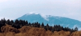
Marys Peak is a mountain in Benton County
, Oregon
, United States
, just southwest of Philomath
. It is the highest peak in the Oregon Coast Range
. It is also the highest point in Benton County,
and ranks eleventh in the state for prominence.
On a clear day at the top of the peak, facing east, northeast, and southeast, one can see the cities and suburbs of the Willamette Valley
, as well as the Cascade Range
. To the west, the Pacific Ocean is visible on clear days.
The road to the peak now remains open in the winter. During the 2010-2011 winter the Forest Service announced they will leave the gates open to facilitate travel to the summit. The road will not be maintained so a lifted 4x4 or 4 wheel chains are required for access during the winter months. ttp://www.fs.usda.gov/wps/portal/fsinternet/!ut/p/c5/04_SB8K8xLLM9MSSzPy8xBz9CP0os3gDfxMDT8MwRydLA1cj72DTgBAjAwgAykeaxcN4jhYG_h4eYX5hPgYwefy6w0H24dcPNgEHcDTQ9_PIz03VL8iNMMgycVQEAObEnGA!/dl3/d3/L2dJQSEvUUt3QS9ZQnZ3LzZfME80MEkxVkFCOTBFMktTNUJIMjAwMDAwMDA!/?navtype=BROWSEBYSUBJECT&recid=42311&actid=&navid=110000000000000&pnavid=&ss=110612&position=&ttype=recarea&pname=Siuslaw%20National%20Forest%20-%20Marys%20]
Benton County, Oregon
-National protected areas:*Siuslaw National Forest *William L. Finley National Wildlife Refuge-Demographics:As of the census of 2000, there were 78,153 people, 30,145 households, and 18,237 families residing in the county. The population density was 116 people per square mile . There were 31,980...
, Oregon
Oregon
Oregon is a state in the Pacific Northwest region of the United States. It is located on the Pacific coast, with Washington to the north, California to the south, Nevada on the southeast and Idaho to the east. The Columbia and Snake rivers delineate much of Oregon's northern and eastern...
, United States
United States
The United States of America is a federal constitutional republic comprising fifty states and a federal district...
, just southwest of Philomath
Philomath, Oregon
Philomath is a city in Benton County, Oregon, United States. It was named for Philomath College. The population was 3,838 at the 2000 census. It is part of the Corvallis, Oregon Metropolitan Statistical Area.- History :...
. It is the highest peak in the Oregon Coast Range
Oregon Coast Range
The Oregon Coast Range, often called simply the Coast Range and sometimes the Pacific Coast Range, is a mountain range, in the Pacific Coast Ranges physiographic region, in the U.S. state of Oregon along the Pacific Ocean...
. It is also the highest point in Benton County,
and ranks eleventh in the state for prominence.
On a clear day at the top of the peak, facing east, northeast, and southeast, one can see the cities and suburbs of the Willamette Valley
Willamette Valley
The Willamette Valley is the most populated region in the state of Oregon of the United States. Located in the state's northwest, the region is surrounded by tall mountain ranges to the east, west and south and the valley's floor is broad, flat and fertile because of Ice Age conditions...
, as well as the Cascade Range
Cascade Range
The Cascade Range is a major mountain range of western North America, extending from southern British Columbia through Washington and Oregon to Northern California. It includes both non-volcanic mountains, such as the North Cascades, and the notable volcanoes known as the High Cascades...
. To the west, the Pacific Ocean is visible on clear days.
The road to the peak now remains open in the winter. During the 2010-2011 winter the Forest Service announced they will leave the gates open to facilitate travel to the summit. The road will not be maintained so a lifted 4x4 or 4 wheel chains are required for access during the winter months. ttp://www.fs.usda.gov/wps/portal/fsinternet/!ut/p/c5/04_SB8K8xLLM9MSSzPy8xBz9CP0os3gDfxMDT8MwRydLA1cj72DTgBAjAwgAykeaxcN4jhYG_h4eYX5hPgYwefy6w0H24dcPNgEHcDTQ9_PIz03VL8iNMMgycVQEAObEnGA!/dl3/d3/L2dJQSEvUUt3QS9ZQnZ3LzZfME80MEkxVkFCOTBFMktTNUJIMjAwMDAwMDA!/?navtype=BROWSEBYSUBJECT&recid=42311&actid=&navid=110000000000000&pnavid=&ss=110612&position=&ttype=recarea&pname=Siuslaw%20National%20Forest%20-%20Marys%20]