
Maryland Route 650
Encyclopedia
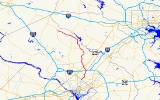
Maryland Route 650 is a state highway
in the U.S. state
of Maryland
. Known as New Hampshire Avenue for most of its length, the state highway runs 25.89 mi (41.7 km) from Eastern Avenue
at the Washington, D.C.
border north to MD 108
in Etchison. MD 650 serves as a major north-south commuter route in southwestern Prince George's County
and eastern Montgomery County
, connecting the District of Columbia with the residential suburbs of Takoma Park
, Langley Park, Maryland
, Adelphi
, Hillandale
, White Oak
, and Colesville
. By contrast, the part of MD 650 north of Spencerville
is a quiet rural road connecting several small communities along the northeastern fringe of Montgomery County.
MD 650 was originally built between Takoma Park and Adelphi in the late 1930s as an extension of New Hampshire Avenue
out of Washington. In the 1950s, the state highway was extended north, taking over portions of MD 320
and U.S. Route 29
(US 29) and all of MD 116. Beginning in the 1950s and continuing through the 1990s, MD 650 has been expanded to a multi-lane divided highway in stages from its southern terminus north to Spencerville.
on the border of Washington, D.C.
. New Hampshire Avenue
continues south into the District of Columbia. MD 650 heads northeast as a six-lane divided highway with a speed limit of 35 mph (56.3 km/h) lined with shopping centers. The state highway straddles the border between Prince George's County on the east and Montgomery County on the west, as well as the eastern border of the city of Takoma Park
. MD 650 intersects Poplar Avenue and Ray Road, which were formerly MD 204, before the present state highway meets MD 410
, which heads west as Philadelphia Avenue and east as East–West Highway. After crossing MD 410, MD 650 fully enters both Takoma Park and Montgomery County. The state highway heads into a forested area with some residences, where it intersects Sligo Creek Parkway
and the Sligo Creek Trail
on a bridge crossing Sligo Creek
. MD 650 continues into an area of apartment buildings and single family residences, then passes between a couple of shopping centers before intersecting MD 193
(University Boulevard) in Langley Park.
MD 650 continues north into Prince George's County for the second time. After passing more shopping centers and apartment complexes, the state highway crosses Northwest Branch
and then immediately meets MD 320 at its eastern terminus. The speed limit increases to 40 mph (64.4 km/h) as the highway enters Adelphi. MD 650 continues through apartment complexes and passes Metzerott Road on the east and Northampton Drive on the west, where the route enters Montgomery County for good. The state highway heads past residences on service roads and intersects Adelphi Road, which heads toward the University of Maryland
. MD 650 meets the Capital Beltway
at a cloverleaf interchange
in Hillandale. After passing a shopping center on the right, the state highway reaches an intersection with the National Labor College
on the west and Powder Mill Road, which heads east toward MD 212
.
 MD 650 turns northwest through residential areas in White Oak. The northbound direction gains a fourth lane ahead of passing the former Naval Ordnance Laboratory
campus to the east, which is now occupied by the Food and Drug Administration
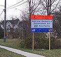
. After passing the federal research center, MD 650 enters a commercial area and intersects Lockwood Drive, which was formerly Maryland Route 895. The state highway then meets US 29 at a cloverleaf interchange where the northbound direction reduces back to three lanes. The stretch of road north of US 29 includes the first official infrastructure repair project started under the American Recovery and Reinvestment Act of 2009
, a repaving job and sidewalk improvements between Milestone Drive and Venice Drive. MD 650 then enters a commercial area in Colesville, where the highway intersects Randolph Road
. The speed limit then increases to 45 mph (72.4 km/h) as MD 650 continues through residential areas north of Colesville. The state highway comes to the interchange with MD 200 (Intercounty Connector), after which the road slims down to a four-lane divided highway ahead of the intersection with Good Hope Road and Bonifant Road. MD 650 then enters Cloverly
, which features intersections with Norwood Road, which leads west to MD 182
, and Briggs Chaney Road, which leads east back to US 29. After leaving Cloverly, the state highway continues through a forested area with scattered subdivisions before reaching the intersection of MD 198
(Spencerville Road) and Norbeck Road, which leads west to MD 28
.
 North of Spencerville, MD 650 becomes a two-lane road with a speed limit of 50 mph (80.5 km/h) passing several churches, subdivisions, and the Hampshire Greens Golf Course to the west. The state highway passes through the hamlet of Ednor
, where it intersects Ednor Road and passes by the historic home Clifton
. After Ednor Road, the speed limit drops to 40 mph (64.4 km/h) as MD 650 continues through forested areas with scattered residential subdivisions. As the state highway approaches the community of Ashton
, the speed limit drops to 30 mph (48.3 km/h). MD 650 meets MD 108
, which is named Olney Sandy Spring Road headed west and Ashton Road headed east at an intersection surrounded by a few small shopping centers.
MD 650 turns north and the speed limit increases to 40 mph (64.4 km/h) as the route heads through a mix of farms and scattered residences on large lots. After passing through the hamlet of Brinklow
, the state highway turns to the northwest as it crosses the Hawlings River
. MD 650 intersects Brighton Dam Road, which heads west toward Brookeville
. After passing several subdivisions of large houses and under some transmission lines, the speed limit drops to 30 mph (48.3 km/h) and MD 650 enters the hamlet of Sunshine, where the road intersects Maryland Route 97
(Georgia Avenue). After crossing MD 97, MD 650 changes its name to Damascus Road. The next hamlet is Unity, where Sundown Road splits to the west toward Laytonsville
. After leaving Unity, the speed limit returns to 40 mph (64.4 km/h) and the state highway continues northwest through scattered subdivisions and farmland. The speed limit again drops to 30 mph (48.3 km/h) as MD 650 enters the unincorporated community of Etchison, where the state highway reaches its northern terminus at its second meeting with MD 108. MD 108 heads south and east toward Laytonsville
as Laytonsville Road, while that state highway takes over Damascus Road toward Damascus
.
The remainder of the current alignment resulted from MD 650 taking over parts of three other routes between 1955 and 1960: MD 320, US 29, and Maryland Route 116 (Damascus Road). MD 320 continued north from its eastern terminus to the current intersection with Lockwood Drive in White Oak. From there, US 29 used Colesville Road through the namesake village up to Ashton, where the federal highway used the route of present-day MD 108 east to Ellicott City
. MD 116 continued north and west to the present northern terminus of MD 650. MD 116 originally only went from Ashton north to Brighton in 1930, but the former state highway was extended north to Sunshine in 1949 and Etchison in 1956.
MD 650 assumed MD 320's route north to White Oak in 1955. The next year, the original portion of MD 650 was rebuilt as a multi-lane divided highway. In 1960, MD 650 took over the old route of US 29 between White Oak and Ashton when US 29 was shifted to the new Columbia Pike, then took over all of MD 116. The divided highway was extended to White Oak in the 1960s, to Colesville in the 1970s, and to Spencerville in the 1990s.
State highway
State highway, state road or state route can refer to one of three related concepts, two of them related to a state or provincial government in a country that is divided into states or provinces :#A...
in the U.S. state
U.S. state
A U.S. state is any one of the 50 federated states of the United States of America that share sovereignty with the federal government. Because of this shared sovereignty, an American is a citizen both of the federal entity and of his or her state of domicile. Four states use the official title of...
of Maryland
Maryland
Maryland is a U.S. state located in the Mid Atlantic region of the United States, bordering Virginia, West Virginia, and the District of Columbia to its south and west; Pennsylvania to its north; and Delaware to its east...
. Known as New Hampshire Avenue for most of its length, the state highway runs 25.89 mi (41.7 km) from Eastern Avenue
Eastern Avenue (Washington, D.C.)
Eastern Avenue is one of three boundary streets between Washington, D.C., and the state of Maryland. It follows a northwest-to-southeast line, beginning at the intersection of 16th Street NW and Colesville Road...
at the Washington, D.C.
Washington, D.C.
Washington, D.C., formally the District of Columbia and commonly referred to as Washington, "the District", or simply D.C., is the capital of the United States. On July 16, 1790, the United States Congress approved the creation of a permanent national capital as permitted by the U.S. Constitution....
border north to MD 108
Maryland Route 108
Maryland Route 108 is a suburban state highway in the central part of the U.S. state of Maryland, starting in Damascus and ending near Columbia.-Route description:...
in Etchison. MD 650 serves as a major north-south commuter route in southwestern Prince George's County
Prince George's County, Maryland
Prince George's County is a county located in the U.S. state of Maryland, immediately north, east, and south of Washington, DC. As of 2010, it has a population of 863,420 and is the wealthiest African-American majority county in the nation....
and eastern Montgomery County
Montgomery County, Maryland
Montgomery County is a county in the U.S. state of Maryland, situated just to the north of Washington, D.C., and southwest of the city of Baltimore. It is one of the most affluent counties in the United States, and has the highest percentage of residents over 25 years of age who hold post-graduate...
, connecting the District of Columbia with the residential suburbs of Takoma Park
Takoma Park, Maryland
Takoma Park is a city in Montgomery County, Maryland, United States. It is a suburb of Washington, D.C., and part of the Washington Metropolitan Area. Founded in 1883 and incorporated in 1890, Takoma Park, informally called "Azalea City," is a Tree City USA and a nuclear-free zone...
, Langley Park, Maryland
Langley Park, Maryland
Langley Park is an unincorporated area and census-designated place in the Washington, D.C. metro area. It is located inside the Capital Beltway, on the northwest edge of Prince George's County, Maryland, bordering Montgomery County, Maryland....
, Adelphi
Adelphi, Maryland
Adelphi is an unincorporated area and census-designated place in Prince George's County, Maryland, United States. The population was 14,998 at the 2000 census...
, Hillandale
Hillandale, Maryland
Hillandale is an unincorporated area located on the boundary between Montgomery and Prince George's Counties, Maryland.-Geography:As an unincorporated area, Hillandale's boundaries are not officially defined...
, White Oak
White Oak, Maryland
White Oak is a census-designated place and an unincorporated area in Montgomery County, Maryland, United States.-Geography:As an unincorporated area, White Oak's boundaries are not officially defined...
, and Colesville
Colesville, Maryland
Colesville is a census-designated place and an unincorporated area in Montgomery County, Maryland in the USA.-Geography:As an unincorporated area, Colesville's boundaries are not officially defined. Also, many residents consider the town to be one of the many neighborhoods of Silver Spring, Maryland...
. By contrast, the part of MD 650 north of Spencerville
Spencerville, Maryland
Spencerville is an unincorporated community in Montgomery County, Maryland, United States. Spencerville is north of Cloverly. Spencerville has a post office with ZIP code 20868....
is a quiet rural road connecting several small communities along the northeastern fringe of Montgomery County.
MD 650 was originally built between Takoma Park and Adelphi in the late 1930s as an extension of New Hampshire Avenue
New Hampshire Avenue
New Hampshire Avenue is a diagonal street in Washington, D.C., beginning at the Kennedy Center and extending northeast for about 5 miles and then continuing into Maryland where it is designated Maryland Route 650. New Hampshire Avenue, however, is not contiguous...
out of Washington. In the 1950s, the state highway was extended north, taking over portions of MD 320
Maryland Route 320
Maryland Route 320 is a state highway in the U.S. state of Maryland. Known as Piney Branch Road, the route runs from Eastern Avenue at the Washington, D.C. border north to Maryland Route 650 in Adelphi.-Route description:...
and U.S. Route 29
U.S. Route 29 in Maryland
U.S. Route 29 is a north–south United States highway that runs for from the western suburbs of Baltimore, Maryland, to Pensacola, Florida. In the U.S. state of Maryland, US 29 is a major highway that emerges from Washington D.C. and runs north into eastern Montgomery County, stretching...
(US 29) and all of MD 116. Beginning in the 1950s and continuing through the 1990s, MD 650 has been expanded to a multi-lane divided highway in stages from its southern terminus north to Spencerville.
Route description
MD 650 begins at Eastern AvenueEastern Avenue (Washington, D.C.)
Eastern Avenue is one of three boundary streets between Washington, D.C., and the state of Maryland. It follows a northwest-to-southeast line, beginning at the intersection of 16th Street NW and Colesville Road...
on the border of Washington, D.C.
Washington, D.C.
Washington, D.C., formally the District of Columbia and commonly referred to as Washington, "the District", or simply D.C., is the capital of the United States. On July 16, 1790, the United States Congress approved the creation of a permanent national capital as permitted by the U.S. Constitution....
. New Hampshire Avenue
New Hampshire Avenue
New Hampshire Avenue is a diagonal street in Washington, D.C., beginning at the Kennedy Center and extending northeast for about 5 miles and then continuing into Maryland where it is designated Maryland Route 650. New Hampshire Avenue, however, is not contiguous...
continues south into the District of Columbia. MD 650 heads northeast as a six-lane divided highway with a speed limit of 35 mph (56.3 km/h) lined with shopping centers. The state highway straddles the border between Prince George's County on the east and Montgomery County on the west, as well as the eastern border of the city of Takoma Park
Takoma Park, Maryland
Takoma Park is a city in Montgomery County, Maryland, United States. It is a suburb of Washington, D.C., and part of the Washington Metropolitan Area. Founded in 1883 and incorporated in 1890, Takoma Park, informally called "Azalea City," is a Tree City USA and a nuclear-free zone...
. MD 650 intersects Poplar Avenue and Ray Road, which were formerly MD 204, before the present state highway meets MD 410
Maryland Route 410
Maryland Route 410 is a state highway in the U.S. state of Maryland. Known for most of its length as East–West Highway, the highway runs from MD 355 in Bethesda east to Pennsy Drive in Landover Hills...
, which heads west as Philadelphia Avenue and east as East–West Highway. After crossing MD 410, MD 650 fully enters both Takoma Park and Montgomery County. The state highway heads into a forested area with some residences, where it intersects Sligo Creek Parkway
Sligo Creek Parkway
Sligo Creek Parkway is two-lane at-grade automobile parkway in Montgomery County in the U.S. state of Maryland. The two-lane parkway runs from Maryland Route 650 in Takoma Park through Silver Spring north to MD 193 in Maryland...
and the Sligo Creek Trail
Sligo Creek Trail
Sligo Creek Trail is a paved hiker-biker trail running along Sligo Creek in the suburbs of Washington, D.C. Most of the trail passes through tree-filled parkland. The trail and surrounding park is a popular place for locals to jog, walk, bicycle, roller-skate, and take their children to the...
on a bridge crossing Sligo Creek
Sligo Creek
Sligo Creek is a free-flowing tributary of the Northwest Branch of the Anacostia River in Maryland. The creek is approximately long, with a drainage area of about .- Geography :The creek rises in the Kemp Mill section of Silver Spring in Montgomery County and...
. MD 650 continues into an area of apartment buildings and single family residences, then passes between a couple of shopping centers before intersecting MD 193
Maryland Route 193
Maryland Route 193 is a state highway in the U.S. state of Maryland. Known for most of its length as University Boulevard and Greenbelt Road, the state highway runs from MD 185 in Kensington east to MD 202 in Greater Upper Marlboro...
(University Boulevard) in Langley Park.
MD 650 continues north into Prince George's County for the second time. After passing more shopping centers and apartment complexes, the state highway crosses Northwest Branch
Northwest Branch Anacostia River
Northwest Branch Anacostia River is a free-flowing stream in Montgomery County and Prince George's County, Maryland. It is a tributary of the Anacostia River, which flows to the Potomac River and the Chesapeake Bay.-Course:...
and then immediately meets MD 320 at its eastern terminus. The speed limit increases to 40 mph (64.4 km/h) as the highway enters Adelphi. MD 650 continues through apartment complexes and passes Metzerott Road on the east and Northampton Drive on the west, where the route enters Montgomery County for good. The state highway heads past residences on service roads and intersects Adelphi Road, which heads toward the University of Maryland
University of Maryland, College Park
The University of Maryland, College Park is a top-ranked public research university located in the city of College Park in Prince George's County, Maryland, just outside Washington, D.C...
. MD 650 meets the Capital Beltway
Interstate 495 (Capital Beltway)
Interstate 495 is a Interstate Highway that surrounds the United States' capital of Washington, D.C., and its inner suburbs in adjacent Maryland and Virginia. I-495 is widely known as the Capital Beltway or simply the Beltway, especially when the context of Washington, D.C., is clear...
at a cloverleaf interchange
Cloverleaf interchange
A cloverleaf interchange is a two-level interchange in which left turns, reverse direction in left-driving regions, are handled by ramp roads...
in Hillandale. After passing a shopping center on the right, the state highway reaches an intersection with the National Labor College
National Labor College
The National Labor College is the only accredited higher education institution in the United States devoted exclusively to educating union members, leaders and staff. It was established as a training center by the AFL-CIO in 1969 to strengthen union member education and organizing skills...
on the west and Powder Mill Road, which heads east toward MD 212
Maryland Route 212
Maryland Route 212, also known as Riggs Road south of MD 193 and Powder Mill Road to its northern end, is a state highway which crosses northern Prince George's County.-Route description:...
.
Naval Ordnance Laboratory
The Naval Ordnance Laboratory , now disestablished, formerly located in White Oak, Maryland was the site of considerable work that had practical impact upon world technology. The White Oak site of NOL has now been taken over by the Food and Drug Administration.-History:The U.S...
campus to the east, which is now occupied by the Food and Drug Administration
Food and Drug Administration
The Food and Drug Administration is an agency of the United States Department of Health and Human Services, one of the United States federal executive departments...
. After passing the federal research center, MD 650 enters a commercial area and intersects Lockwood Drive, which was formerly Maryland Route 895. The state highway then meets US 29 at a cloverleaf interchange where the northbound direction reduces back to three lanes. The stretch of road north of US 29 includes the first official infrastructure repair project started under the American Recovery and Reinvestment Act of 2009
American Recovery and Reinvestment Act of 2009
The American Recovery and Reinvestment Act of 2009, abbreviated ARRA and commonly referred to as the Stimulus or The Recovery Act, is an economic stimulus package enacted by the 111th United States Congress in February 2009 and signed into law on February 17, 2009, by President Barack Obama.To...
, a repaving job and sidewalk improvements between Milestone Drive and Venice Drive. MD 650 then enters a commercial area in Colesville, where the highway intersects Randolph Road
Randolph Road
Randolph Road is a major cross-county road in Montgomery County, Maryland, and is part of a longer road that runs across Montgomery and Prince George's counties. The full road, which is also known as Montrose Road on the western end and Cherry Hill Road at the southeast, runs between the Potomac...
. The speed limit then increases to 45 mph (72.4 km/h) as MD 650 continues through residential areas north of Colesville. The state highway comes to the interchange with MD 200 (Intercounty Connector), after which the road slims down to a four-lane divided highway ahead of the intersection with Good Hope Road and Bonifant Road. MD 650 then enters Cloverly
Cloverly, Maryland
Cloverly is a census-designated place and an unincorporated town in Montgomery County, Maryland, United States.-Geography:As an unincorporated area, Cloverly's boundaries are not officially defined. Many residents consider themselves to live in a neighborhood of Silver Spring, Maryland, the...
, which features intersections with Norwood Road, which leads west to MD 182
Maryland Route 182
Maryland Route 182 is a road that runs between Olney and Glenmont, Maryland. The road is first known as Dr. Bird Road for a short distance before becoming Norwood Road. When the road reaches Norwood, a right turn is required to stay on the route, which for its remainder is known as Layhill Road...
, and Briggs Chaney Road, which leads east back to US 29. After leaving Cloverly, the state highway continues through a forested area with scattered subdivisions before reaching the intersection of MD 198
Maryland Route 198
Maryland Route 198 is an east–west state highway in the central part of the U.S. state of Maryland that connects Fort Meade at Maryland Route 32 to Maryland Route 28 and Maryland Route 650 near Spencerville.-Spencerville Road:...
(Spencerville Road) and Norbeck Road, which leads west to MD 28
Maryland Route 28
Maryland Route 28 is a state highway in the U.S. state of Maryland. The state highway runs from U.S. Route 15 in Point of Rocks east to MD 182 in Norwood. The western portion of MD 28 is a rural highway connecting several villages in southern Frederick County and western Montgomery County...
.
Ednor, Maryland
Ednor is an unincorporated community in Montgomery County, Maryland, United States.-References:...
, where it intersects Ednor Road and passes by the historic home Clifton
Clifton (Ednor, Maryland)
Clifton is a historic home located at Ednor, Montgomery County, Maryland, United States. It is a -story gambrel-roofed brick structure with a lower north wing, also with a gambrel roof. Outbuildings on the property include a wood-frame shed and a guest house or cottage...
. After Ednor Road, the speed limit drops to 40 mph (64.4 km/h) as MD 650 continues through forested areas with scattered residential subdivisions. As the state highway approaches the community of Ashton
Ashton, Maryland
Ashton is an unincorporated area in Montgomery County, Maryland. The commercial center of Ashton lies at the junction of Route 108 and New Hampshire Avenue ....
, the speed limit drops to 30 mph (48.3 km/h). MD 650 meets MD 108
Maryland Route 108
Maryland Route 108 is a suburban state highway in the central part of the U.S. state of Maryland, starting in Damascus and ending near Columbia.-Route description:...
, which is named Olney Sandy Spring Road headed west and Ashton Road headed east at an intersection surrounded by a few small shopping centers.
MD 650 turns north and the speed limit increases to 40 mph (64.4 km/h) as the route heads through a mix of farms and scattered residences on large lots. After passing through the hamlet of Brinklow
Brinklow, Maryland
Brinklow is an unincorporated community in Montgomery County, Maryland, United States. Brinklow is located on Maryland Route 650 northeast of Olney. Brinklow has a post office with ZIP code 20862....
, the state highway turns to the northwest as it crosses the Hawlings River
Hawlings River
Hawlings River is a tributary of the Patuxent River in Montgomery County, Maryland. The watershed covers an area of about . The headwaters of the river originate in the area north of Laytonsville, and the river flows southeast, entering the Patuxent about below the Triadelphia Reservoir. Portions...
. MD 650 intersects Brighton Dam Road, which heads west toward Brookeville
Brookeville, Maryland
Brookeville is a town located twenty miles north of Washington, D.C. and two miles north of Olney in northeastern Montgomery County, Maryland. Brookeville was settled by Quakers late in the 18th century, and was formally incorporated as a town in 1808...
. After passing several subdivisions of large houses and under some transmission lines, the speed limit drops to 30 mph (48.3 km/h) and MD 650 enters the hamlet of Sunshine, where the road intersects Maryland Route 97
Maryland Route 97
Maryland Route 97 is a state highway in the U.S. state of Maryland. The route runs from U.S. Route 29 in Silver Spring, Montgomery County north to the Pennsylvania border in Carroll County, where the road continues into that state as Pennsylvania Route 97...
(Georgia Avenue). After crossing MD 97, MD 650 changes its name to Damascus Road. The next hamlet is Unity, where Sundown Road splits to the west toward Laytonsville
Laytonsville, Maryland
Laytonsville is a town in Montgomery County, Maryland, United States. The population was 277 at the 2000 census. Laytonsville was originally known as Cracklintown. This name originated from the popular cracklin bread, which was baked in the locale. This recipe, essentially a bacon corn bread, also...
. After leaving Unity, the speed limit returns to 40 mph (64.4 km/h) and the state highway continues northwest through scattered subdivisions and farmland. The speed limit again drops to 30 mph (48.3 km/h) as MD 650 enters the unincorporated community of Etchison, where the state highway reaches its northern terminus at its second meeting with MD 108. MD 108 heads south and east toward Laytonsville
Laytonsville, Maryland
Laytonsville is a town in Montgomery County, Maryland, United States. The population was 277 at the 2000 census. Laytonsville was originally known as Cracklintown. This name originated from the popular cracklin bread, which was baked in the locale. This recipe, essentially a bacon corn bread, also...
as Laytonsville Road, while that state highway takes over Damascus Road toward Damascus
Damascus, Maryland
Damascus is a census-designated place and an unincorporated area in Montgomery County, Maryland, United States.In the early part of the 20th century, there was an incorporated municipality there for about a quarter century, but it no longer exists...
.
History
MD 650 began as a continuation of New Hampshire Avenue out of Washington. The state highway was planned by 1935 roughly following Sligo Mill Road to the site of the defunct mill at the current intersection with Sligo Creek Parkway, then east to near the intersection of MD 193 and MD 212 in Langley Park. By 1939, MD 650 was complete between Eastern Avenue and MD 193, but along its present alignment. The segment between MD 193 and MD 320 had also started construction, which was complete by 1946.The remainder of the current alignment resulted from MD 650 taking over parts of three other routes between 1955 and 1960: MD 320, US 29, and Maryland Route 116 (Damascus Road). MD 320 continued north from its eastern terminus to the current intersection with Lockwood Drive in White Oak. From there, US 29 used Colesville Road through the namesake village up to Ashton, where the federal highway used the route of present-day MD 108 east to Ellicott City
Ellicott City, Maryland
Ellicott City is an unincorporated community and census-designated place in Howard County, Maryland, United States. It is part of the Baltimore-Washington Metropolitan Area. The population was 65,834 at the 2010 census. It is the county seat of Howard County...
. MD 116 continued north and west to the present northern terminus of MD 650. MD 116 originally only went from Ashton north to Brighton in 1930, but the former state highway was extended north to Sunshine in 1949 and Etchison in 1956.
MD 650 assumed MD 320's route north to White Oak in 1955. The next year, the original portion of MD 650 was rebuilt as a multi-lane divided highway. In 1960, MD 650 took over the old route of US 29 between White Oak and Ashton when US 29 was shifted to the new Columbia Pike, then took over all of MD 116. The divided highway was extended to White Oak in the 1960s, to Colesville in the 1970s, and to Spencerville in the 1990s.
Junction list
| County | Location | Mile |
Destinations | Notes |
|---|---|---|---|---|
| Prince George's Prince George's County, Maryland Prince George's County is a county located in the U.S. state of Maryland, immediately north, east, and south of Washington, DC. As of 2010, it has a population of 863,420 and is the wealthiest African-American majority county in the nation.... 0.81 miles (1.3 km) |
Takoma Park Takoma Park, Maryland Takoma Park is a city in Montgomery County, Maryland, United States. It is a suburb of Washington, D.C., and part of the Washington Metropolitan Area. Founded in 1883 and incorporated in 1890, Takoma Park, informally called "Azalea City," is a Tree City USA and a nuclear-free zone... |
0.00 | New Hampshire Avenue New Hampshire Avenue New Hampshire Avenue is a diagonal street in Washington, D.C., beginning at the Kennedy Center and extending northeast for about 5 miles and then continuing into Maryland where it is designated Maryland Route 650. New Hampshire Avenue, however, is not contiguous... south / Eastern Avenue Eastern Avenue (Washington, D.C.) Eastern Avenue is one of three boundary streets between Washington, D.C., and the state of Maryland. It follows a northwest-to-southeast line, beginning at the intersection of 16th Street NW and Colesville Road... – Washington Washington, D.C. Washington, D.C., formally the District of Columbia and commonly referred to as Washington, "the District", or simply D.C., is the capital of the United States. On July 16, 1790, the United States Congress approved the creation of a permanent national capital as permitted by the U.S. Constitution.... |
Southern terminus |
| 0.43 | Ray Road east / Poplar Avenue west – Chillum Chillum, Maryland Chillum is an unincorporated area and census-designated place in Prince George's County, Maryland, United States. The population was 34,252 at the 2000 census... , Takoma Park Takoma Park, Maryland Takoma Park is a city in Montgomery County, Maryland, United States. It is a suburb of Washington, D.C., and part of the Washington Metropolitan Area. Founded in 1883 and incorporated in 1890, Takoma Park, informally called "Azalea City," is a Tree City USA and a nuclear-free zone... |
Former MD 204 | ||
| 0.81 | ||||
| Montgomery Montgomery County, Maryland Montgomery County is a county in the U.S. state of Maryland, situated just to the north of Washington, D.C., and southwest of the city of Baltimore. It is one of the most affluent counties in the United States, and has the highest percentage of residents over 25 years of age who hold post-graduate... 1.04 miles (1.7 km) |
Sligo Creek Parkway Sligo Creek Parkway Sligo Creek Parkway is two-lane at-grade automobile parkway in Montgomery County in the U.S. state of Maryland. The two-lane parkway runs from Maryland Route 650 in Takoma Park through Silver Spring north to MD 193 in Maryland... west – Takoma Park Takoma Park, Maryland Takoma Park is a city in Montgomery County, Maryland, United States. It is a suburb of Washington, D.C., and part of the Washington Metropolitan Area. Founded in 1883 and incorporated in 1890, Takoma Park, informally called "Azalea City," is a Tree City USA and a nuclear-free zone... |
|||
| Prince George's Prince George's County, Maryland Prince George's County is a county located in the U.S. state of Maryland, immediately north, east, and south of Washington, DC. As of 2010, it has a population of 863,420 and is the wealthiest African-American majority county in the nation.... 1.31 miles (2.1 km) |
Langley Park Langley Park, Maryland Langley Park is an unincorporated area and census-designated place in the Washington, D.C. metro area. It is located inside the Capital Beltway, on the northwest edge of Prince George's County, Maryland, bordering Montgomery County, Maryland.... |
1.85 | ||
| Adelphi Adelphi, Maryland Adelphi is an unincorporated area and census-designated place in Prince George's County, Maryland, United States. The population was 14,998 at the 2000 census... |
2.78 | |||
| Montgomery Montgomery County, Maryland Montgomery County is a county in the U.S. state of Maryland, situated just to the north of Washington, D.C., and southwest of the city of Baltimore. It is one of the most affluent counties in the United States, and has the highest percentage of residents over 25 years of age who hold post-graduate... 22.73 miles (36.6 km) |
Adelphi Road east – University of Maryland University of Maryland, College Park The University of Maryland, College Park is a top-ranked public research university located in the city of College Park in Prince George's County, Maryland, just outside Washington, D.C... |
|||
| Hillandale Hillandale, Maryland Hillandale is an unincorporated area located on the boundary between Montgomery and Prince George's Counties, Maryland.-Geography:As an unincorporated area, Hillandale's boundaries are not officially defined... |
, Northern Virginia Northern Virginia Northern Virginia consists of several counties and independent cities in the Commonwealth of Virginia, in a widespread region generally radiating southerly and westward from Washington, D.C... |
I-495 Interchange 28 | ||
| Powder Mill Road east to – Calverton Calverton, Maryland Calverton is an unincorporated area and Census-designated place located on the boundary between Montgomery and Prince George's Counties, Maryland.-Geography:As an unincorporated area, Calverton's boundaries are not officially defined... |
||||
| White Oak White Oak, Maryland White Oak is a census-designated place and an unincorporated area in Montgomery County, Maryland, United States.-Geography:As an unincorporated area, White Oak's boundaries are not officially defined... |
0 | Lockwood Drive | Former MD 895 | |
| Cloverleaf interchange | ||||
| Colesville Colesville, Maryland Colesville is a census-designated place and an unincorporated area in Montgomery County, Maryland in the USA.-Geography:As an unincorporated area, Colesville's boundaries are not officially defined. Also, many residents consider the town to be one of the many neighborhoods of Silver Spring, Maryland... |
Randolph Road Randolph Road Randolph Road is a major cross-county road in Montgomery County, Maryland, and is part of a longer road that runs across Montgomery and Prince George's counties. The full road, which is also known as Montrose Road on the western end and Cherry Hill Road at the southeast, runs between the Potomac... – Glenmont Glenmont, Maryland Glenmont is an unincorporated community in Montgomery County, Maryland, USA. The U.S. Census Bureau combines Glenmont with nearby Wheaton to create the Census Designated Place of Wheaton-Glenmont.- Location :... , Calverton Calverton, Maryland Calverton is an unincorporated area and Census-designated place located on the boundary between Montgomery and Prince George's Counties, Maryland.-Geography:As an unincorporated area, Calverton's boundaries are not officially defined... |
Randolph Road west is former MD 183 | ||
| Single-Point Urban Interchange; Opened November 22, 2011 | ||||
| Cloverly Cloverly, Maryland Cloverly is a census-designated place and an unincorporated town in Montgomery County, Maryland, United States.-Geography:As an unincorporated area, Cloverly's boundaries are not officially defined. Many residents consider themselves to live in a neighborhood of Silver Spring, Maryland, the... |
Norwood Road north to – Sandy Spring Sandy Spring, Maryland Sandy Spring, Maryland is an unincorporated community in Montgomery County, Maryland.The community was founded by Quakers who arrived in the early 18th century searching for land where they could grow tobacco and corn. One of the very early land owners in the Sandy Spring area was Richard Snowden,... |
|||
| Spencerville Spencerville, Maryland Spencerville is an unincorporated community in Montgomery County, Maryland, United States. Spencerville is north of Cloverly. Spencerville has a post office with ZIP code 20868.... |
/ Norbeck Road west to – Burtonsville Burtonsville, Maryland Burtonsville is a census-designated place and an unincorporated area in Montgomery County, Maryland, United States.-History:In colonial times, the area was referred to as the Patuxent Hundred and later the Eastern Branch Hundred, a community comprising about 100 inhabitants... , Laurel Laurel, Maryland Laurel is a city in northern Prince George's County, Anne Arundel County, and Howard County, Maryland, United States, located midway between Washington, D.C. and Baltimore. Incorporated in 1870, the city maintains a historic district including its Main Street... , Norbeck Norbeck, Maryland Norbeck is the area of Montgomery County, Maryland around Norbeck Road east of Georgia Avenue to Layhill Road.A museum in Sandy Spring, Maryland provides the information that Norbeck is the:Southwestern outpost of the greater Sandy Spring neighborhood [and] put down roots as a free-black community... |
|||
| Ashton Ashton, Maryland Ashton is an unincorporated area in Montgomery County, Maryland. The commercial center of Ashton lies at the junction of Route 108 and New Hampshire Avenue .... |
||||
| Sunshine | ||||
| Unity | Sundown Road west – Laytonsville Laytonsville, Maryland Laytonsville is a town in Montgomery County, Maryland, United States. The population was 277 at the 2000 census. Laytonsville was originally known as Cracklintown. This name originated from the popular cracklin bread, which was baked in the locale. This recipe, essentially a bacon corn bread, also... |
Former MD 701 | ||
| Etchison | Northern terminus | |||