
Maryland Route 45
Encyclopedia
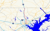
Maryland Route 45 is a state highway
in the U.S. state of Maryland
. Known for most of its length as York Road, the state highway runs 30.06 miles (48.4 km) from U.S. Route 1
(US 1) in Baltimore north to the Pennsylvania
state line in Maryland Line
, where the highway continues as SR 3001. MD 45 is the primary highway between Downtown Baltimore
and Towson
, the county seat
of Baltimore County
. North of Interstate 695
, the state highway parallels I-83
and serves the suburban communities of Lutherville, Timonium, Cockeysville
, and Hunt Valley
. MD 45 also connects the northern Baltimore County communities of Hereford
and Parkton
. The state highway is maintained by the Maryland State Highway Administration
in Baltimore County and by the Baltimore City Department of Transportation in the city, where the highway also follows Greenmount Avenue.
York Road, which follows the path of an 18th century wagon road and 19th century turnpike, was one of the original state roads marked for improvement by the Maryland State Roads Commission in 1909. The state highway was constructed as an all-weather road in the mid-1910s from Baltimore to Hereford. The remainder of York Road to Maryland Line was built in the late 1910s and early 1920s. York Road was designated US 111
in 1927 and widened to handle the increasing traffic load in the late 1920s. York Road became a secondary route when a freeway was constructed from Baltimore to York
and Harrisburg
in the 1950s. US 111 was moved to this freeway as sections opened; the old road became MD 45. MD 45 fully replaced US 111 on York Road when the U.S. Highway was replaced by I-83 in the early 1960s.
. MD 45 heads north as a four-lane undivided street between the Barclay
and East Baltimore Midway
neighborhoods and crosses over CSX
's Baltimore Terminal Subdivision. The state highway continues north through Waverly
, where the street passes St. John's Episcopal Church and intersects 33rd Street. MD 45 is paralleled to the east by Old York Road through Waverly and Pen Lucy
. At 43rd Street, MD 45's name changes to York Road. The name change occurs where the highway exited the city limits of Baltimore between 1888 and 1917. MD 45 continues north as a five-lane road with center turn lane. Between Cold Spring Lane and Northern Parkway, the state highway passes through Mid-Govans
, which is home to the Senator Theater.
MD 45 leaves the city limits and passes through the Baltimore County community of Rodgers Forge
. The state highway passes along the eastern margin of Towson University before reaching the southern edge of downtown Towson, where MD 45 Bypass splits to the northwest along Burke Avenue. In the center of the county seat adjacent to Towson Town Center
, MD 45 passes through the racetrack-shaped Towson Roundabout, where the state highway meets the southern end of MD 146
(Dulaney Valley Road) and east–west Joppa Road. On either side of the roundabout
, the state highway narrows to two lanes for on-street parking. MD 45 heads northwest from the roundabout and meets the northern end of MD 45 Bypass (Bosley Avenue) and has a partial cloverleaf interchange with I-695 (Baltimore Beltway). The state highway continues north through the densely-populated suburban area of Lutherville where the highway intersects Seminary Road, which heads west as MD 131
. The west side of MD 45 is lined with commercial and industrial parks as it passes through Timonium. Between Timonium Road and Padonia Road, both of which head west to interchanges with I-83, the state highway passes along the edge of the Timonium Fairgrounds, home of the Maryland State Fair
. The industrial parks continue past Warren Road in Cockeysville, where the highway crosses Beaver Dam Run. MD 45 meets the western end of MD 145
(Ashland Road) before arriving in Hunt Valley, where the highway intersects Shawan Road at Hunt Valley Town Center.
North of Shawan Road, MD 45 becomes a two-lane road that crosses Western Run and curves northeast before resuming its northward course through the community of Sparks, where the highway has an intersection with Belfast Road and passes several industrial parks. The state highway continues through the village of Hereford, which contains the western terminus of MD 138
(Monkton Road) and the eastern terminus of MD 137
(Mount Carmel Road) one block apart. North of Hereford, MD 45 descends into the valley of Gunpowder Falls, where the highway closely parallels I-83. The two highways separate, with the state highway passing by the Half-Way House, a preserved toll house from the 19th century turnpike that is halfway between Baltimore and York. In Parkton, MD 45 intersects Middletown Road and passes over the Northern Central Railroad Trail
and Little Gunpowder Falls. North of the village, the state highway crosses to the west side of I-83 at a diamond interchange
with the Interstate. The state highway intersects MD 439
(Old York Road) and Freeland Road in the community of Maryland Line before reaching its northern terminus at the Pennsylvania state line. The roadway continues north as SR 3001 (Susquehanna Trail) toward the borough of Shrewsbury.
Early improvements to York Road included the construction of new bridges over Western Run and Gunpowder Falls in 1918 and 1924; these bridges remain in use. Other bridges included grade separations at the crossings of the Northern Central Railway at Cockeysville and Parkton built around 1930. US 111 was widened with concrete shoulders in much of Baltimore County in the mid- to late 1920s. York Road and Greenmount Avenue were widened and reconstructed in Baltimore in 1929 and 1930. By 1930, US 111 had a width of 40 feet (12.2 m) from inside Baltimore to Towson, 20 feet (6.1 m) from Towson to Parkton, and 18 feet (5.5 m) from Parkton to the Pennsylvania state line. By 1934, the Maryland State Roads Commission recommended widening the U.S. Highway to 40 feet (12.2 m) from Towson to Cockeysville and to 20 feet (6.1 m) from Parkton to the Pennsylvania state line. The latter stretch was widened to 24 feet (7.3 m) in 1946 and 1947.
Further widening of US 111 was not planned because York Road was to be bypassed by a freeway between Baltimore and Harrisburg. Construction on the Baltimore–Harrisburg Expressway got underway in 1948 between Timonium and Hunt Valley. The first portion of the freeway opened from Towson to Belfast Road north of Hunt Valley in December 1955, concurrent with the opening of the portion of the Baltimore Beltway between Falls Road and York Road. US 111 was moved to the freeway when the Baltimore–Harrisburg Expressway was completed to north of Hereford in 1957; MD 45 was assigned to York Road between the Beltway and the northern end of the freeway. A second, disjoint portion of MD 45 was assigned from north of Parkton to the Pennsylvania state line when the Baltimore–Harrisburg Expressway was completed between Parkton and the York area in 1959. When the final section of the US 111 freeway was completed between Hereford and Parkton in 1960, MD 45 was assigned to the stretch of York Road between those communities. US 111 and I-83 were co-signed on the freeway between Towson and Harrisburg until US 111 was decommissioned in 1963; the MD 45 designation was extended south into Baltimore to US 1 at that time.
!County
!Location
!Mile
!Destinations
!Notes
|-
|colspan=2 rowspan=4|Baltimore City
|0.00
|
|Southern terminus
|-
|1.19
|33rd Street
|
|-
|2.42
|Cold Spring Lane
|
|-
|3.74
|Northern Parkway
|
|-
|rowspan=11|Baltimore
|rowspan=4|Towson
|5.89
|
|Southern terminus of MD 45 Bypass
|-
|6.36
|
|Towson Roundabout
|-
|6.82
|
|Northern terminus of MD 45 Bypass
|-
|7.36
|
|I-695 Exit 26
|-
|Lutherville
|7.90
|
|
|-
|Cockeysville
|13.12
|
|
|-
|rowspan=2|Hereford
|20.33
|
|
|-
|20.43
|
|
|-
|Parkton
|25.35
|
|I-83 Exit 33
|-
|rowspan=2|Maryland Line
|28.81
|
|
|-
|30.06
|
|Northern terminus; Pennsylvania
state line
State highway
State highway, state road or state route can refer to one of three related concepts, two of them related to a state or provincial government in a country that is divided into states or provinces :#A...
in the U.S. state of Maryland
Maryland
Maryland is a U.S. state located in the Mid Atlantic region of the United States, bordering Virginia, West Virginia, and the District of Columbia to its south and west; Pennsylvania to its north; and Delaware to its east...
. Known for most of its length as York Road, the state highway runs 30.06 miles (48.4 km) from U.S. Route 1
U.S. Route 1 in Maryland
U.S. Route 1 is the easternmost and longest of the major north–south routes of the United States Numbered Highway System, running from Key West, Florida to Fort Kent, Maine. In the U.S...
(US 1) in Baltimore north to the Pennsylvania
Pennsylvania
The Commonwealth of Pennsylvania is a U.S. state that is located in the Northeastern and Mid-Atlantic regions of the United States. The state borders Delaware and Maryland to the south, West Virginia to the southwest, Ohio to the west, New York and Ontario, Canada, to the north, and New Jersey to...
state line in Maryland Line
Maryland Line, Maryland
Maryland Line is an unincorporated town in Baltimore County, Maryland just south of the Mason-Dixon Line below York County, Pennsylvania after Exit 35. It is accessible from exits 36 and 37 off I-83....
, where the highway continues as SR 3001. MD 45 is the primary highway between Downtown Baltimore
Downtown Baltimore
Downtown Baltimore is the section of Baltimore traditionally bounded by Martin Luther King, Jr. Boulevard to the west, Mt. Royal Avenue to the north, President Street to the east and the Inner Harbor area to the south. It consists of four neighborhoods: Westside, City Centre, Inner Harbor, and...
and Towson
Towson, Maryland
Towson is an unincorporated community and a census-designated place in Baltimore County, Maryland, United States. The population was 55,197 at the 2010 census...
, the county seat
County seat
A county seat is an administrative center, or seat of government, for a county or civil parish. The term is primarily used in the United States....
of Baltimore County
Baltimore County, Maryland
Baltimore County is a county located in the northern part of the US state of Maryland. In 2010, its population was 805,029. It is part of the Baltimore-Washington Metropolitan Area. Its county seat is Towson. The name of the county was derived from the barony of the Proprietor of the Maryland...
. North of Interstate 695
Interstate 695 (Maryland)
Interstate 695 is a -long full beltway Interstate Highway extending around Baltimore, Maryland, USA. I-695 is officially designated the McKeldin Beltway, but is colloquially referred to as either the Baltimore Beltway or 695...
, the state highway parallels I-83
Interstate 83
Interstate 83 is an Interstate Highway in the eastern United States. Its southern terminus is in Baltimore, Maryland at the Fayette Street exit; its northern terminus is in Harrisburg, Pennsylvania at Interstate 81....
and serves the suburban communities of Lutherville, Timonium, Cockeysville
Cockeysville, Maryland
Cockeysville is a census-designated place in Baltimore County, Maryland, United States. The population was 19,388 at the 2000 census.-History:...
, and Hunt Valley
Hunt Valley, Maryland
Hunt Valley is an affluent unincorporated community in Baltimore County, Maryland, United States. It lies just north of the city of Baltimore, along Highway 145 off Interstate 83. Loch Raven Reservoir...
. MD 45 also connects the northern Baltimore County communities of Hereford
Hereford, Maryland
Hereford is an unincorporated community in Baltimore County, Maryland, United States....
and Parkton
Parkton, Maryland
Parkton is a rural area in the northern part of Baltimore County, Maryland, USA. It borders southern York County, PA, and this border forms part of The Mason-Dixon Line...
. The state highway is maintained by the Maryland State Highway Administration
Maryland State Highway Administration
The Maryland State Highway Administration is the state agency responsible for maintaining Maryland numbered highways outside of Baltimore City...
in Baltimore County and by the Baltimore City Department of Transportation in the city, where the highway also follows Greenmount Avenue.
York Road, which follows the path of an 18th century wagon road and 19th century turnpike, was one of the original state roads marked for improvement by the Maryland State Roads Commission in 1909. The state highway was constructed as an all-weather road in the mid-1910s from Baltimore to Hereford. The remainder of York Road to Maryland Line was built in the late 1910s and early 1920s. York Road was designated US 111
U.S. Route 111
U.S. Route 111 was a U.S. Route that ran from Baltimore, Maryland north to the Harrisburg, Pennsylvania area. It replaced part of the Susquehanna Trail and was in turn replaced by Interstate 83. Portions of its pre-freeway alignment are now Maryland Route 45 and Interstate 83 Business...
in 1927 and widened to handle the increasing traffic load in the late 1920s. York Road became a secondary route when a freeway was constructed from Baltimore to York
York, Pennsylvania
York, known as the White Rose City , is a city located in York County, Pennsylvania, United States which is in the South Central region of the state. The population within the city limits was 43,718 at the 2010 census, which was a 7.0% increase from the 2000 count of 40,862...
and Harrisburg
Harrisburg, Pennsylvania
Harrisburg is the capital of Pennsylvania. As of the 2010 census, the city had a population of 49,528, making it the ninth largest city in Pennsylvania...
in the 1950s. US 111 was moved to this freeway as sections opened; the old road became MD 45. MD 45 fully replaced US 111 on York Road when the U.S. Highway was replaced by I-83 in the early 1960s.
Route description
MD 45 begins at an intersection with US 1 (North Avenue) at the northwest corner of Green Mount Cemetery in Baltimore. Greenmount Avenue continues south as a city street to Forrest Street and Monument Street east of Downtown BaltimoreDowntown Baltimore
Downtown Baltimore is the section of Baltimore traditionally bounded by Martin Luther King, Jr. Boulevard to the west, Mt. Royal Avenue to the north, President Street to the east and the Inner Harbor area to the south. It consists of four neighborhoods: Westside, City Centre, Inner Harbor, and...
. MD 45 heads north as a four-lane undivided street between the Barclay
Barclay, Baltimore
The Barclay neighborhood, as defined by the Baltimore City Planning Department, is bounded by North Avenue, Greenmount Avenue, Saint Paul and 25th Streets. The neighborhood lies north of Greenmount West, south of Charles Village, west of East Baltimore Midway, and east of Charles North...
and East Baltimore Midway
East Baltimore Midway, Baltimore
East Baltimore Midway is a neighborhood in the Eastern district of Baltimore, Maryland. Its boundaries are the south side of 25th Street, the east side of Greenmount Avenue, the west side of Harford Road, and the north side of North Avenue. The neighborhood lies East of Barclay, North of Oliver,...
neighborhoods and crosses over CSX
CSX Transportation
CSX Transportation operates a Class I railroad in the United States known as the CSX Railroad. It is the main subsidiary of the CSX Corporation. The company is headquartered in Jacksonville, Florida, and owns approximately 21,000 route miles...
's Baltimore Terminal Subdivision. The state highway continues north through Waverly
Waverly, Baltimore
Waverly is a historic village in Baltimore, Maryland, United States. Located near I-83, York Road and major bus connections, Waverly provides access to downtown Baltimore, Towson, and the Baltimore Beltway...
, where the street passes St. John's Episcopal Church and intersects 33rd Street. MD 45 is paralleled to the east by Old York Road through Waverly and Pen Lucy
Pen Lucy, Baltimore
Pen Lucy is a small community in the North District of Baltimore and part of the development of York Road, a historic Baltimore route to Pennsylvania. The Pen Lucy neighborhood is predominately African American and features many different housing types. The neighborhood is bounded by Argonne Drive...
. At 43rd Street, MD 45's name changes to York Road. The name change occurs where the highway exited the city limits of Baltimore between 1888 and 1917. MD 45 continues north as a five-lane road with center turn lane. Between Cold Spring Lane and Northern Parkway, the state highway passes through Mid-Govans
Mid-Govans, Baltimore
Mid-Govans is a community in northeast Baltimore, Maryland and part of the development of York Road, a historic Baltimore route to Pennsylvania.-Points of interest:...
, which is home to the Senator Theater.
MD 45 leaves the city limits and passes through the Baltimore County community of Rodgers Forge
Rodgers Forge, Maryland
Rodgers Forge is a neighborhood located in the unincorporated Towson area of Baltimore County, Maryland, just north of the Baltimore City/County line. It is mostly a residential area, with rowhouses, apartments, single family dwellings, and a new complex of luxury garaged townhomes. The area also...
. The state highway passes along the eastern margin of Towson University before reaching the southern edge of downtown Towson, where MD 45 Bypass splits to the northwest along Burke Avenue. In the center of the county seat adjacent to Towson Town Center
Towson Town Center
Towson Town Center is a large indoor shopping mall located in Towson, Maryland. It was the largest indoor shopping mall in Maryland prior to the completion of Arundel Mills in late 2000 in Hanover and the 2007 expansion of the Annapolis Mall.- History :...
, MD 45 passes through the racetrack-shaped Towson Roundabout, where the state highway meets the southern end of MD 146
Maryland Route 146
Maryland Route 146 is a state highway in the U.S. state of Maryland. The state highway runs from MD 45 in Towson north to MD 23 near Jarrettsville. MD 146 connects Towson with Loch Raven Reservoir, an impoundment of Gunpowder Falls. The state highway also serves the northern Baltimore County...
(Dulaney Valley Road) and east–west Joppa Road. On either side of the roundabout
Roundabout
A roundabout is the name for a road junction in which traffic moves in one direction around a central island. The word dates from the early 20th century. Roundabouts are common in many countries around the world...
, the state highway narrows to two lanes for on-street parking. MD 45 heads northwest from the roundabout and meets the northern end of MD 45 Bypass (Bosley Avenue) and has a partial cloverleaf interchange with I-695 (Baltimore Beltway). The state highway continues north through the densely-populated suburban area of Lutherville where the highway intersects Seminary Road, which heads west as MD 131
Maryland Route 131
Maryland Route 131 , identified locally as Seminary Avenue, is a route in Baltimore County that runs from the area of Lutherville known as Brooklandville to Providence Road in Parkville. The route runs east–west, parallel to and just slightly north of the Baltimore Beltway, and is used by...
. The west side of MD 45 is lined with commercial and industrial parks as it passes through Timonium. Between Timonium Road and Padonia Road, both of which head west to interchanges with I-83, the state highway passes along the edge of the Timonium Fairgrounds, home of the Maryland State Fair
Maryland State Fair
The Maryland State Fair is the annual state fair for the state of Maryland. It is held at the Maryland State Fairgrounds located near the intersection of York and Timonium Roads in Timonium. As of 2006, the fair is an 11-day event customarily beginning in late August and ending around Labor Day.-...
. The industrial parks continue past Warren Road in Cockeysville, where the highway crosses Beaver Dam Run. MD 45 meets the western end of MD 145
Maryland Route 145
Maryland Route 145 is a state highway in the U.S. state of Maryland. The state highway runs from MD 45 in Hunt Valley east to MD 165 near Baldwin. MD 145 connects the north-central and eastern portions of Baltimore County via Jacksonville. The first section of the highway was built from Loch...
(Ashland Road) before arriving in Hunt Valley, where the highway intersects Shawan Road at Hunt Valley Town Center.
North of Shawan Road, MD 45 becomes a two-lane road that crosses Western Run and curves northeast before resuming its northward course through the community of Sparks, where the highway has an intersection with Belfast Road and passes several industrial parks. The state highway continues through the village of Hereford, which contains the western terminus of MD 138
Maryland Route 138
Maryland Route 138 is a state highway in the U.S. state of Maryland. The state highway runs from MD 45 in Hereford east to MD 23 near Shawsville. MD 138 connects northern Baltimore County with northwestern Harford County via the community of Monkton on Gunpowder Falls. The first section of the...
(Monkton Road) and the eastern terminus of MD 137
Maryland Route 137
Maryland Route 137 is a state highway in the U.S. state of Maryland. MD 137, also known as Mount Carmel Road, is an east–west road which runs from the traffic circle created by Maryland Route 88, commonly known as Black Rock Road in Hampstead, Maryland, and runs through Maryland Route 25,...
(Mount Carmel Road) one block apart. North of Hereford, MD 45 descends into the valley of Gunpowder Falls, where the highway closely parallels I-83. The two highways separate, with the state highway passing by the Half-Way House, a preserved toll house from the 19th century turnpike that is halfway between Baltimore and York. In Parkton, MD 45 intersects Middletown Road and passes over the Northern Central Railroad Trail
Northern Central Railroad Trail
The Torrey C. Brown Trail, formerly known as the Northern Central Railroad Trail is a rail trail that runs along an abandoned railroad corridor where the Northern Central Railway used to run. The trails extends from Cockeysville, Maryland to the boundary with Pennsylvania. At the Pennsylvania...
and Little Gunpowder Falls. North of the village, the state highway crosses to the west side of I-83 at a diamond interchange
Diamond interchange
A diamond interchange is a common type of road junction, used where a freeway crosses a minor road. The freeway itself is grade-separated from the minor road, one crossing the other over a bridge...
with the Interstate. The state highway intersects MD 439
Maryland Route 439
Maryland Route 439 is a state highway in the U.S. state of Maryland. Known as Old York Road, the state highway runs from MD 45 in Maryland Line east to MD 23 in Shawsville. In conjunction with MD 23 and Interstate 83 , MD 439 connects Bel Air with York, Pennsylvania. The state highway was...
(Old York Road) and Freeland Road in the community of Maryland Line before reaching its northern terminus at the Pennsylvania state line. The roadway continues north as SR 3001 (Susquehanna Trail) toward the borough of Shrewsbury.
History
York Road was first constructed as a wagon road in the early 1740s to connect the new settlement of York with the port of Baltimore. In the 19th century, this road became part of the Baltimore and Yorktown Turnpike. When the Maryland State Roads Commission put together a state road system in 1909, York Road from North Avenue in Baltimore to Parkton was designated one of the original state roads to be improved. The first section of the old turnpike to be resurfaced with a 14 feet (4.3 m) wide macadam surface was from Washington Avenue just north of the center of Towson and the hamlet of Texas south of Cockeysville in 1913. The highway from the contemporary northern city limit of Baltimore near 42nd Street to Washington Avenue just north of the center of Towson was surfaced with bituminous concrete in 1914. York Road from Texas to Glencoe was resurfaced in 1914 and from there to the hamlet of Verona south of Hereford in 1915. The improved macadam road was extended to Parkton by 1919. York Road from Parkton to the Pennsylvania state line was paved in concrete in two sections completed in 1921 and 1923. Greenmount Avenue was reconstructed from 42nd Street to its southern end by 1924. In 1927, York Road and Greenmount Avenue north of North Avenue became part of US 111.Early improvements to York Road included the construction of new bridges over Western Run and Gunpowder Falls in 1918 and 1924; these bridges remain in use. Other bridges included grade separations at the crossings of the Northern Central Railway at Cockeysville and Parkton built around 1930. US 111 was widened with concrete shoulders in much of Baltimore County in the mid- to late 1920s. York Road and Greenmount Avenue were widened and reconstructed in Baltimore in 1929 and 1930. By 1930, US 111 had a width of 40 feet (12.2 m) from inside Baltimore to Towson, 20 feet (6.1 m) from Towson to Parkton, and 18 feet (5.5 m) from Parkton to the Pennsylvania state line. By 1934, the Maryland State Roads Commission recommended widening the U.S. Highway to 40 feet (12.2 m) from Towson to Cockeysville and to 20 feet (6.1 m) from Parkton to the Pennsylvania state line. The latter stretch was widened to 24 feet (7.3 m) in 1946 and 1947.
Further widening of US 111 was not planned because York Road was to be bypassed by a freeway between Baltimore and Harrisburg. Construction on the Baltimore–Harrisburg Expressway got underway in 1948 between Timonium and Hunt Valley. The first portion of the freeway opened from Towson to Belfast Road north of Hunt Valley in December 1955, concurrent with the opening of the portion of the Baltimore Beltway between Falls Road and York Road. US 111 was moved to the freeway when the Baltimore–Harrisburg Expressway was completed to north of Hereford in 1957; MD 45 was assigned to York Road between the Beltway and the northern end of the freeway. A second, disjoint portion of MD 45 was assigned from north of Parkton to the Pennsylvania state line when the Baltimore–Harrisburg Expressway was completed between Parkton and the York area in 1959. When the final section of the US 111 freeway was completed between Hereford and Parkton in 1960, MD 45 was assigned to the stretch of York Road between those communities. US 111 and I-83 were co-signed on the freeway between Towson and Harrisburg until US 111 was decommissioned in 1963; the MD 45 designation was extended south into Baltimore to US 1 at that time.
Junction list
{|class=wikitable!County
!Location
!Mile
!Destinations
!Notes
|-
|colspan=2 rowspan=4|Baltimore City
|0.00
|
|Southern terminus
|-
|1.19
|33rd Street
|
|-
|2.42
|Cold Spring Lane
|
|-
|3.74
|Northern Parkway
|
|-
|rowspan=11|Baltimore
Baltimore County, Maryland
Baltimore County is a county located in the northern part of the US state of Maryland. In 2010, its population was 805,029. It is part of the Baltimore-Washington Metropolitan Area. Its county seat is Towson. The name of the county was derived from the barony of the Proprietor of the Maryland...
|rowspan=4|Towson
Towson, Maryland
Towson is an unincorporated community and a census-designated place in Baltimore County, Maryland, United States. The population was 55,197 at the 2010 census...
|5.89
|
|Southern terminus of MD 45 Bypass
|-
|6.36
|
|Towson Roundabout
|-
|6.82
|
|Northern terminus of MD 45 Bypass
|-
|7.36
|
|I-695 Exit 26
|-
|Lutherville
|7.90
|
|
|-
|Cockeysville
Cockeysville, Maryland
Cockeysville is a census-designated place in Baltimore County, Maryland, United States. The population was 19,388 at the 2000 census.-History:...
|13.12
|
|
|-
|rowspan=2|Hereford
Hereford, Maryland
Hereford is an unincorporated community in Baltimore County, Maryland, United States....
|20.33
|
|
|-
|20.43
|
|
|-
|Parkton
Parkton, Maryland
Parkton is a rural area in the northern part of Baltimore County, Maryland, USA. It borders southern York County, PA, and this border forms part of The Mason-Dixon Line...
|25.35
|
|I-83 Exit 33
|-
|rowspan=2|Maryland Line
Maryland Line, Maryland
Maryland Line is an unincorporated town in Baltimore County, Maryland just south of the Mason-Dixon Line below York County, Pennsylvania after Exit 35. It is accessible from exits 36 and 37 off I-83....
|28.81
|
|
|-
|30.06
|
|Northern terminus; Pennsylvania
Pennsylvania
The Commonwealth of Pennsylvania is a U.S. state that is located in the Northeastern and Mid-Atlantic regions of the United States. The state borders Delaware and Maryland to the south, West Virginia to the southwest, Ohio to the west, New York and Ontario, Canada, to the north, and New Jersey to...
state line
Towson bypass route
Maryland Route 45 Bypass (MD 45 Bypass) is a county-maintained, signed bypass route of MD 45 in Towson. The four- to six-lane divided highway runs 0.9 miles (1.4 km) along the west side of downtown Towson. MD 45 Bypass begins south of downtown at MD 45's intersection with Burke Avenue. At Towsontown Boulevard on the north edge of the Towson University campus, the bypass route curves north and its name changes to Bosley Avenue. MD 45 Bypass follows Bosley Avenue north past Joppa Road to MD 45 north of the Towson Roundabout. Bosley Avenue continues northeast beyond MD 45 to Fairmount Avenue.Auxiliary routes
MD 45 has five unsigned auxiliary routes. MD 45A is in Towson; MD 45B through MD 45E are in Cockeysville.- MD 45A is the designation for the 0.11 mile (0.1770274 km) section of West Road between MD 45 and a pair of ramps to and from eastbound I-695.
- MD 45B is the designation for the 0.05 mile (0.080467 km) segment of Cockeysville Road immediately west of MD 45.
- MD 45C is the designation for the 0.03 mile (0.0482802 km) section of Railroad Avenue immediately west of MD 45.
- MD 45D is the designation for the 0.05 mile (0.080467 km) segment of Sherwood Road between MD 45 and Cedar Knoll Road.
- MD 45E is the designation for the 0.03 mile (0.0482802 km) section of Beaver Run Lane immediately east of MD 45.