
Maryland Route 216
Encyclopedia
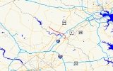
Maryland Route 216 is a Maryland
between Laurel
and Highland
, primarily within Howard County
. The name for Route 216 is Scaggsville Road.
) in downtown Laurel
. After crossing Talbot Ave (westbound MD 198) the route continues northward as an inner-city street, eventually crossing Montgomery St and Main St. At the Main St intersection, maintenance responsibility for MD 216 switches from the city of Laurel to MDOT SHA.
via a high-level bridge about a mile downstream from Rocky Gorge Reservoir
. Continuing to the northwest, the route intersects All Saints Rd. at a traditional traffic light and Stephens Rd. via ramp before upgrading to a limited-access expressway. In this format, the route interchanges with Interstate 95
at a full cloverleaf. Northwest of the interchange, MD 216 crosses Leishear Road near a major BG&E electrical substation
, continuing northwest before meeting US 29
at a folded-diamond interchange in Scaggsville
controlled by two traffic circles. After crossing US 29, MD 216 downgrades to a two-lane country road and continues to the north-northwest, passing through Fulton
before reaching its northern terminus at MD 108
in Highland
.
demands. Prior to this realignment, MD 216 was a broken route; the limited-access expressway ended at Leishear Rd., and traffic was forced to turn left and access MD 216's original alignment via the county-maintained street. With the completion of the limited-access parkway between Leishear Rd. and US 29, MD 216 is now a continuous route between MD 108 in Highland and MD 198 in Laurel; Old Scaggsville Rd. (MD 216E and MD 983) survives under state maintenance.
Funding for the construction of the missing segment of MD 216 was provided by the developer of property in the northeast and northwest quadrants of the I-95/MD216 interchange
.
with an eastern terminus at Fort Meade, near the current eastern terminus of MD 198. Instead of entering Laurel at 7th Street, MD 216 crossed the Patuxent River over a now-defunct bridge at 9th Street.
MD 216 turned east onto Main Street and followed it past the one-lane railroad bridge to Main Street's current eastern end. At that point, MD 216 turned northeast and crossed another now-defunct bridge over the Patuxent River onto the grounds of Laurel Park in Anne Arundel County.
For some time after this path changed in the 1950s, MD 216 continued south on 9th Street to a terminus at MD 198.
in the early 1950s, the "MD 216" designation was removed within Anne Arundel County. Three state-maintained segments of this road remain:
The rest of this former eastward section of MD 216 was subsumed by MD 198 (Laurel Fort Meade Rd), business and residential development, and nature.
The segment of Old Scaggsville Road bypassed by the new construction between US 29 and Leishear Road in Howard County was redesignated Maryland Route 216E.
Maryland
Maryland is a U.S. state located in the Mid Atlantic region of the United States, bordering Virginia, West Virginia, and the District of Columbia to its south and west; Pennsylvania to its north; and Delaware to its east...
between Laurel
Laurel, Maryland
Laurel is a city in northern Prince George's County, Anne Arundel County, and Howard County, Maryland, United States, located midway between Washington, D.C. and Baltimore. Incorporated in 1870, the city maintains a historic district including its Main Street...
and Highland
Highland, Maryland
Highland is an unincorporated community in western Howard County, Maryland which uses the 20777 zip code. The community is located at the junction of Highland Road, Maryland Route 216 and Maryland Route 108, and is still heavily influenced by its agrarian history; farms and horse fields are common...
, primarily within Howard County
Howard County, Maryland
-2010:Whereas according to the 2010 U.S. Census Bureau:*62.2% White*17.5% Black*0.3% Native American*14.4% Asian*0.0% Native Hawaiian or Pacific Islander*3.6% Two or more races*2.0% Other races*5.8% Hispanic or Latino -2000:...
. The name for Route 216 is Scaggsville Road.
7th Street, Laurel
MD 216 begins at the intersection between 7th St and Gorman Avenue (eastbound MD 198Maryland Route 198
Maryland Route 198 is an east–west state highway in the central part of the U.S. state of Maryland that connects Fort Meade at Maryland Route 32 to Maryland Route 28 and Maryland Route 650 near Spencerville.-Spencerville Road:...
) in downtown Laurel
Laurel, Maryland
Laurel is a city in northern Prince George's County, Anne Arundel County, and Howard County, Maryland, United States, located midway between Washington, D.C. and Baltimore. Incorporated in 1870, the city maintains a historic district including its Main Street...
. After crossing Talbot Ave (westbound MD 198) the route continues northward as an inner-city street, eventually crossing Montgomery St and Main St. At the Main St intersection, maintenance responsibility for MD 216 switches from the city of Laurel to MDOT SHA.
Scaggsville Road
Beyond Main St., MD 216 assumes the name of Scaggsville Rd. (though most signage in Prince George's County uses the "MD 216" notation) and continues north, crossing the Patuxent RiverPatuxent River
The Patuxent River is a tributary of the Chesapeake Bay in the state of Maryland. There are three main river drainages for central Maryland: the Potomac River to the west passing through Washington D.C., the Patapsco River to the northeast passing through Baltimore, and the Patuxent River between...
via a high-level bridge about a mile downstream from Rocky Gorge Reservoir
Rocky Gorge Reservoir
Rocky Gorge Reservoir is located on the Patuxent River in Howard County, Montgomery County and Prince George’s County, Maryland near the town of Burtonsville. The reservoir was created in 1952 by the construction of the T. Howard Duckett Dam on the Patuxent. The dam is visible from Interstate 95...
. Continuing to the northwest, the route intersects All Saints Rd. at a traditional traffic light and Stephens Rd. via ramp before upgrading to a limited-access expressway. In this format, the route interchanges with Interstate 95
Interstate 95 in Maryland
Interstate 95 in Maryland is a major highway that runs diagonally from northeast to southwest, from Maryland's border with Delaware, to the Woodrow Wilson Bridge, briefly entering the District of Columbia before reaching Virginia...
at a full cloverleaf. Northwest of the interchange, MD 216 crosses Leishear Road near a major BG&E electrical substation
Electrical substation
A substation is a part of an electrical generation, transmission, and distribution system. Substations transform voltage from high to low, or the reverse, or perform any of several other important functions...
, continuing northwest before meeting US 29
U.S. Route 29 in Maryland
U.S. Route 29 is a north–south United States highway that runs for from the western suburbs of Baltimore, Maryland, to Pensacola, Florida. In the U.S. state of Maryland, US 29 is a major highway that emerges from Washington D.C. and runs north into eastern Montgomery County, stretching...
at a folded-diamond interchange in Scaggsville
Scaggsville, Maryland
Scaggsville is an unincorporated community in Maryland. It is situated near the southeastern tip of Howard County, between Laurel and Fulton. The name Scaggsville appears on exits for Maryland Route 216 off Interstate 95 and U.S. Route 29. The town mainly consists of residences, with some...
controlled by two traffic circles. After crossing US 29, MD 216 downgrades to a two-lane country road and continues to the north-northwest, passing through Fulton
Fulton, Maryland
Fulton is an unincorporated community located at the southern tip of Howard County, Maryland.-History:Prior to 1805 Fulton was known as Queen Caroline Parish, then later as Hammond Directions. In 1878, it was referred to as "Water's Store," a name taken from postmaster Richard Waters.Henry Iager...
before reaching its northern terminus at MD 108
Maryland Route 108
Maryland Route 108 is a suburban state highway in the central part of the U.S. state of Maryland, starting in Damascus and ending near Columbia.-Route description:...
in Highland
Highland, Maryland
Highland is an unincorporated community in western Howard County, Maryland which uses the 20777 zip code. The community is located at the junction of Highland Road, Maryland Route 216 and Maryland Route 108, and is still heavily influenced by its agrarian history; farms and horse fields are common...
.
Howard County
The realignment of MD 216 between I-95 and US 29 was completed to address expected growth and increased trafficTraffic
Traffic on roads may consist of pedestrians, ridden or herded animals, vehicles, streetcars and other conveyances, either singly or together, while using the public way for purposes of travel...
demands. Prior to this realignment, MD 216 was a broken route; the limited-access expressway ended at Leishear Rd., and traffic was forced to turn left and access MD 216's original alignment via the county-maintained street. With the completion of the limited-access parkway between Leishear Rd. and US 29, MD 216 is now a continuous route between MD 108 in Highland and MD 198 in Laurel; Old Scaggsville Rd. (MD 216E and MD 983) survives under state maintenance.
Funding for the construction of the missing segment of MD 216 was provided by the developer of property in the northeast and northwest quadrants of the I-95/MD216 interchange
Interchange (road)
In the field of road transport, an interchange is a road junction that typically uses grade separation, and one or more ramps, to permit traffic on at least one highway to pass through the junction without directly crossing any other traffic stream. It differs from a standard intersection, at which...
.
Prince George's County
Prior to the 1950s, MD 216 extended eastward from Laurel into Anne Arundel CountyAnne Arundel County, Maryland
Anne Arundel County is a county located in the U.S. state of Maryland. It is named for Anne Arundell , a member of the ancient family of Arundells in Cornwall, England and the wife of Cæcilius Calvert, 2nd Baron Baltimore. Its county seat is Annapolis, which is also the capital of the state...
with an eastern terminus at Fort Meade, near the current eastern terminus of MD 198. Instead of entering Laurel at 7th Street, MD 216 crossed the Patuxent River over a now-defunct bridge at 9th Street.
MD 216 turned east onto Main Street and followed it past the one-lane railroad bridge to Main Street's current eastern end. At that point, MD 216 turned northeast and crossed another now-defunct bridge over the Patuxent River onto the grounds of Laurel Park in Anne Arundel County.
For some time after this path changed in the 1950s, MD 216 continued south on 9th Street to a terminus at MD 198.
Anne Arundel County
Prior to the 1950s, MD 216 extended across the Laurel Park grounds toward the current intersection of MD 198 and Brock Bridge Road. The portion of MD 216 between Laurel and Fort Meade was known as Old Camp Meade Road. When the route was disjointed by the construction of the Baltimore-Washington ParkwayBaltimore-Washington Parkway
The Baltimore–Washington Parkway is a highway in the U.S. state of Maryland, running southwest from Baltimore to Washington, D.C. The road begins at an interchange with U.S. Route 50 and Maryland Route 201 near Cheverly in Prince George's County at the D.C...
in the early 1950s, the "MD 216" designation was removed within Anne Arundel County. Three state-maintained segments of this road remain:
- A 0.2 mile (0.321868 km) section known as Old Camp Meade Road exists between the Maryland CityMaryland City, MarylandMaryland City is a census-designated place in Anne Arundel County, Maryland, United States, a suburb of Washington, DC. The population was 6,814 at the 2000 census. It is located east of Laurel, just over the border with Prince George's County, and it has a Laurel zip code...
fire station and Whiskey Bottom RoadWhiskey Bottom RoadWhiskey Bottom Road is a historic road north of Laurel, Maryland that traverses Anne Arundel and Howard Counties.-Route description:Whiskey Bottom Road runs through North Laurel, Maryland starting at Maryland Route 198 in Anne Arundel County, Maryland. The road continues westward across U.S...
(where it is blocked with barriers), and continuing across that road behind some businesses. State highway maintenance records list this section as MD 216A. Though very overgrown by nature, remnants of the road continue eastward between homes and business properties until reaching RussettRussett, MarylandRussett is an unincorporated planned community of near Laurel, Maryland in far-western Anne Arundel County, situated in a park-like setting complemented by of walking trails and a lake nature preserve....
Green East.
- A 0.5 mile (0.80467 km) section known as Old Portland Road exists from MD Route 198Maryland Route 198Maryland Route 198 is an east–west state highway in the central part of the U.S. state of Maryland that connects Fort Meade at Maryland Route 32 to Maryland Route 28 and Maryland Route 650 near Spencerville.-Spencerville Road:...
west toward Maya Angelou AcademyMaya Angelou AcademyThe Maya Angelou Academy at New Beginnings, renamed from Oak Hill Academy in May 2009, is an alternative school operated by the non-profit See Forever Foundation...
. State highway maintenance records list this section as MD 216B.
- A 0.04 mile (0.0643736 km) section now known as Welchs Court exists as a spur from MD 198 about 0.1 mile (0.160934 km) east of MD 216B. State highway maintenance records list this section as MD 216C. The former MD 216 passed through this area, parallel with the current Route 198.
The rest of this former eastward section of MD 216 was subsumed by MD 198 (Laurel Fort Meade Rd), business and residential development, and nature.
Junction list
| County | Location | Mile | Destinations | Notes |
|---|---|---|---|---|
| Prince George's Prince George's County, Maryland Prince George's County is a county located in the U.S. state of Maryland, immediately north, east, and south of Washington, DC. As of 2010, it has a population of 863,420 and is the wealthiest African-American majority county in the nation.... |
Laurel Laurel, Maryland Laurel is a city in northern Prince George's County, Anne Arundel County, and Howard County, Maryland, United States, located midway between Washington, D.C. and Baltimore. Incorporated in 1870, the city maintains a historic district including its Main Street... |
0.00 | Southern terminus One-way eastbound |
|
| 0.11 | One-way westbound | |||
| 0.35 | Montgomery Street | |||
| 0.52 | Main Street | eastbound Main Street leads to Laurel MARC MARC Train MARC , known prior to 1984 as Maryland Rail Commuter Service, is a regional rail system comprising three lines in the Baltimore-Washington Metropolitan Area. MARC is administered by the Maryland Transit Administration , a Maryland Department of Transportation agency, and is operated under contract... station; westbound leads to old MD 216 river crossing |
||
| MD 216 changes jurisdiction from Laurel Laurel, Maryland Laurel is a city in northern Prince George's County, Anne Arundel County, and Howard County, Maryland, United States, located midway between Washington, D.C. and Baltimore. Incorporated in 1870, the city maintains a historic district including its Main Street... municipal maintenance to MDOT SHA maintenance and crosses the Patuxent River Patuxent River The Patuxent River is a tributary of the Chesapeake Bay in the state of Maryland. There are three main river drainages for central Maryland: the Potomac River to the west passing through Washington D.C., the Patapsco River to the northeast passing through Baltimore, and the Patuxent River between... |
||||
| Howard Howard County, Maryland -2010:Whereas according to the 2010 U.S. Census Bureau:*62.2% White*17.5% Black*0.3% Native American*14.4% Asian*0.0% Native Hawaiian or Pacific Islander*3.6% Two or more races*2.0% Other races*5.8% Hispanic or Latino -2000:... |
Laurel Laurel, Maryland Laurel is a city in northern Prince George's County, Anne Arundel County, and Howard County, Maryland, United States, located midway between Washington, D.C. and Baltimore. Incorporated in 1870, the city maintains a historic district including its Main Street... |
0.71 | Baltimore Avenue / Pilgrim Avenue – to Old Scaggsville Road | Pilgrim Avenue westbound leads to other side of old old MD 216 river crossing |
| 1.26 | All Saints Road | |||
| 1.49 | Stephens Road east – to Whiskey Bottom Road Whiskey Bottom Road Whiskey Bottom Road is a historic road north of Laurel, Maryland that traverses Anne Arundel and Howard Counties.-Route description:Whiskey Bottom Road runs through North Laurel, Maryland starting at Maryland Route 198 in Anne Arundel County, Maryland. The road continues westward across U.S... |
Interchange No eastbound entrance from Stephens Road west |
||
| 2.18 | , Washington D.C. | Interchange | ||
| 3.3 | ||||
| 4.01 |   |
|||
| Scaggsville Scaggsville, Maryland Scaggsville is an unincorporated community in Maryland. It is situated near the southeastern tip of Howard County, between Laurel and Fulton. The name Scaggsville appears on exits for Maryland Route 216 off Interstate 95 and U.S. Route 29. The town mainly consists of residences, with some... |
4.55 | Ice Crystal Drive | Roundabout Roundabout A roundabout is the name for a road junction in which traffic moves in one direction around a central island. The word dates from the early 20th century. Roundabouts are common in many countries around the world... Unsigned MD 216G |
|
| 4.68 | Interchange | |||
| 4.9 | |
Roundabout Includes link to old segment of MD 216 |
||
| 5.07 | Maple Lawn Boulevard north – Maple Lawn | Roundabout | ||
| 5.21 | Old Columbia Road south (MD 216H) | Former US 29 | ||
| Fulton Fulton, Maryland Fulton is an unincorporated community located at the southern tip of Howard County, Maryland.-History:Prior to 1805 Fulton was known as Queen Caroline Parish, then later as Hammond Directions. In 1878, it was referred to as "Water's Store," a name taken from postmaster Richard Waters.Henry Iager... |
5.89 | Murphy Road | ||
| 5.92 | Lime Kiln Road | |||
| 6.46 | ||||
| 7.55 | Brown Bridge Road | |||
| 8.14 | ||||
| Highland Highland, Maryland Highland is an unincorporated community in western Howard County, Maryland which uses the 20777 zip code. The community is located at the junction of Highland Road, Maryland Route 216 and Maryland Route 108, and is still heavily influenced by its agrarian history; farms and horse fields are common... |
8.70 | Northern terminus Continues as Highland Road |
||
The segment of Old Scaggsville Road bypassed by the new construction between US 29 and Leishear Road in Howard County was redesignated Maryland Route 216E.
| Location | Mile | Destinations | Notes |
|---|---|---|---|
| 0.00 | Eastern terminus | ||
| 0.04 | Harding Road – Rocky Gorge Reservoir Rocky Gorge Reservoir Rocky Gorge Reservoir is located on the Patuxent River in Howard County, Montgomery County and Prince George’s County, Maryland near the town of Burtonsville. The reservoir was created in 1952 by the construction of the T. Howard Duckett Dam on the Patuxent. The dam is visible from Interstate 95... |
||
| Scaggsville Scaggsville, Maryland Scaggsville is an unincorporated community in Maryland. It is situated near the southeastern tip of Howard County, between Laurel and Fulton. The name Scaggsville appears on exits for Maryland Route 216 off Interstate 95 and U.S. Route 29. The town mainly consists of residences, with some... |
0.78 | ||
| 1.10 | Sweet Cherry Lane | ||
| 1.21 | Cul-de-sac Cul-de-sac A cul-de-sac is a word of French origin referring to a dead end, close, no through road or court meaning dead-end street with only one inlet/outlet... |
Western terminus | |