
Maryland, Virginia, and Washington, D.C. tornado outbreak of 2001
Encyclopedia
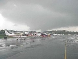
The Maryland, Virginia, and Washington, D.C., tornado outbreak of 2001 was the most dramatic recent tornado event to directly affect the Baltimore-Washington metropolitan area
in the United States
. The outbreak occurred on September 24, 2001, and was responsible for two deaths and 57 injuries.
The first tornado of the outbreak was also the strongest - an F4 (see Fujita scale
) tornado that left a 10-mile-long damage path through rural Culpeper
and Fauquier
Counties in Virginia
. Weak (F1) tornadoes east of Warrenton
, and just west of Dulles International Airport soon followed.
A second supercell
to the southeast spawned the family of tornadoes that moved through Washington. A first tornado (F0) was confirmed in the Quantico
, and nearby Prince William Forest Park
areas; this was soon followed by an F1 tornado that left a 15-mile-long path parallel to I-95
and I-395
through Franconia
, western Alexandria
, and southeastern Arlington. This tornado dissipated near the west end of the National Mall
in Washington, D.C., and was followed by many reports of funnel clouds.
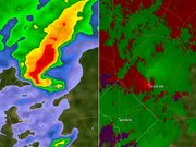 The same storm soon produced a violent, multiple-vortex F3 tornado in College Park, Maryland
. This storm moved at peak intensity through the University of Maryland, College Park
campus, and then moved parallel to I-95 through the Beltsville, Maryland
, area, where the tornado caused extensive damage to greenhouses and other facilities of the USDA Beltsville Agricultural Research Center. The storm continued on to Laurel, Maryland
, where F3 damage was also noted. The damage path from this storm was measured at 17.5 miles in length, and this tornado caused two deaths and 55 injuries, along with $101 million in property damage.
The two deaths at College Park were Colleen and Erin Marlatt, who died when their car was picked up by the tornado near the Easton Hall dormitory and thrown into a tree in a parking area.
Baltimore-Washington Metropolitan Area
The Baltimore-Washington Metropolitan Area is a combined statistical area consisting of the overlapping labor market region of the cities of Baltimore, Maryland and Washington, D.C.. The region includes Central Maryland, Northern Virginia, and Jefferson County in the Eastern Panhandle of West...
in the United States
United States
The United States of America is a federal constitutional republic comprising fifty states and a federal district...
. The outbreak occurred on September 24, 2001, and was responsible for two deaths and 57 injuries.
The first tornado of the outbreak was also the strongest - an F4 (see Fujita scale
Fujita scale
The Fujita scale , or Fujita-Pearson scale, is a scale for rating tornado intensity, based primarily on the damage tornadoes inflict on human-built structures and vegetation...
) tornado that left a 10-mile-long damage path through rural Culpeper
Culpeper County, Virginia
As of the census of 2000, there were 34,262 people, 12,141 households, and 9,045 families residing in the county. The population density was 90 people per square mile . There were 12,871 housing units at an average density of 34 per square mile...
and Fauquier
Fauquier County, Virginia
As of the census of 2000, there were 55,139 people, 19,842 households, and 15,139 families residing in the county. The population density was 85 people per square mile . There were 21,046 housing units at an average density of 32 per square mile...
Counties in Virginia
Virginia
The Commonwealth of Virginia , is a U.S. state on the Atlantic Coast of the Southern United States. Virginia is nicknamed the "Old Dominion" and sometimes the "Mother of Presidents" after the eight U.S. presidents born there...
. Weak (F1) tornadoes east of Warrenton
Warrenton, Virginia
Warrenton is a town in Fauquier County, Virginia, United States. The population was 6,670 at the 2000 census, and 14,634 at the 2010 estimate. It is the county seat of Fauquier County. Public schools in the town include Fauquier High School, Warrenton Middle School, Taylor Middle School and two...
, and just west of Dulles International Airport soon followed.
A second supercell
Supercell
A supercell is a thunderstorm that is characterized by the presence of a mesocyclone: a deep, continuously-rotating updraft. For this reason, these storms are sometimes referred to as rotating thunderstorms...
to the southeast spawned the family of tornadoes that moved through Washington. A first tornado (F0) was confirmed in the Quantico
Quantico, Virginia
- Demographics :As of the census of 2000, there are 561 people, 295 households, and 107 families living in the town. The population density is . There are 359 housing units at an average density of .-Racial composition:...
, and nearby Prince William Forest Park
Prince William Forest Park
Prince William Forest Park was established as Chopawamsic Recreational Demonstration Area in 1936 and is located in southeastern Prince William County, Virginia, adjacent to the Marine Corps Base Quantico. The park is the largest protected natural area in the Washington, D.C. metropolitan region at...
areas; this was soon followed by an F1 tornado that left a 15-mile-long path parallel to I-95
Interstate 95 in Virginia
In the Commonwealth of Virginia, Interstate 95 runs through the state. It runs concurrently for with Interstate 64 in Richmond, and meets the northern terminus of Interstate 85 in Petersburg. Though Interstate 95 was originally planned to go straight through Washington, D.C., it was instead...
and I-395
Interstate 395 (District of Columbia-Virginia)
Interstate 395 in Washington, D.C., and Virginia is a 13 mile long spur route that begins at a junction with Interstate 95 in Springfield, Virginia and ends in northwest Washington, D.C. It passes underneath the National Mall near the United States Capitol and ends at a junction with U.S...
through Franconia
Franconia, Virginia
Franconia is a census-designated place in Fairfax County, Virginia, United States. The population was 18,245 at the 2010 census, down from 31,907 in 2000 due to the splitting off of part of it to form Kingstowne CDP....
, western Alexandria
Alexandria, Virginia
Alexandria is an independent city in the Commonwealth of Virginia. As of 2009, the city had a total population of 139,966. Located along the Western bank of the Potomac River, Alexandria is approximately six miles south of downtown Washington, D.C.Like the rest of northern Virginia, as well as...
, and southeastern Arlington. This tornado dissipated near the west end of the National Mall
National Mall
The National Mall is an open-area national park in downtown Washington, D.C., the capital of the United States. The National Mall is a unit of the National Park Service , and is administered by the National Mall and Memorial Parks unit...
in Washington, D.C., and was followed by many reports of funnel clouds.
College Park, Maryland
College Park is a city in Prince George's County, Maryland, USA. The population was 30,413 at the 2010 census. It is best known as the home of the University of Maryland, College Park, and since 1994 the city has also been home to the "Archives II" facility of the U.S...
. This storm moved at peak intensity through the University of Maryland, College Park
University of Maryland, College Park
The University of Maryland, College Park is a top-ranked public research university located in the city of College Park in Prince George's County, Maryland, just outside Washington, D.C...
campus, and then moved parallel to I-95 through the Beltsville, Maryland
Beltsville, Maryland
Beltsville is a census-designated place in northern Prince George's County, Maryland, United States. The population was 15,691 at the 2000 census. Beltsville includes the unincorporated community of Vansville.-Geography:...
, area, where the tornado caused extensive damage to greenhouses and other facilities of the USDA Beltsville Agricultural Research Center. The storm continued on to Laurel, Maryland
Laurel, Maryland
Laurel is a city in northern Prince George's County, Anne Arundel County, and Howard County, Maryland, United States, located midway between Washington, D.C. and Baltimore. Incorporated in 1870, the city maintains a historic district including its Main Street...
, where F3 damage was also noted. The damage path from this storm was measured at 17.5 miles in length, and this tornado caused two deaths and 55 injuries, along with $101 million in property damage.
The two deaths at College Park were Colleen and Erin Marlatt, who died when their car was picked up by the tornado near the Easton Hall dormitory and thrown into a tree in a parking area.
Confirmed tornadoes
| List of reported tornadoes - September 24, 2001 | ||||||
|---|---|---|---|---|---|---|
Fujita scale The Fujita scale , or Fujita-Pearson scale, is a scale for rating tornado intensity, based primarily on the damage tornadoes inflict on human-built structures and vegetation... |
|
|
|
|
|
|
| Virginia Virginia The Commonwealth of Virginia , is a U.S. state on the Atlantic Coast of the Southern United States. Virginia is nicknamed the "Old Dominion" and sometimes the "Mother of Presidents" after the eight U.S. presidents born there... |
||||||
| F4 | Rixeyville area | Culpeper Culpeper County, Virginia As of the census of 2000, there were 34,262 people, 12,141 households, and 9,045 families residing in the county. The population density was 90 people per square mile . There were 12,871 housing units at an average density of 34 per square mile... , Fauquier Fauquier County, Virginia As of the census of 2000, there were 55,139 people, 19,842 households, and 15,139 families residing in the county. The population density was 85 people per square mile . There were 21,046 housing units at an average density of 32 per square mile... |
38°09′N 78°13′W | 1903 | 10 miles (16.1 km) | |
| F1 | W of Gordonsville Gordonsville, Virginia Gordonsville is a town in Louisa and Orange counties in the U.S. state of Virginia. The population was 1,496 at the 2010 census.-History:Nathaniel Gordon purchased in 1787 and in 1794, or possibly earlier, applied for and was granted a license to operate a tavern... |
Orange Orange County, Virginia As of the census of 2000, there were 25,881 people, 10,150 households, and 7,470 families residing in the county. The population density was 76 people per square mile . There were 11,354 housing units at an average density of 33 per square mile... |
38°34′N 77°59′W | 1935 | 0.2 mile (0.321868 km) | |
| F1 | The Plains The Plains, Virginia The Plains is a town in Fauquier County, Virginia, United States. The population was 266 at the 2000 census. It is centered around Virginia Route 55 and Virginia Route 245... area |
Fauquier Fauquier County, Virginia As of the census of 2000, there were 55,139 people, 19,842 households, and 15,139 families residing in the county. The population density was 85 people per square mile . There were 21,046 housing units at an average density of 32 per square mile... |
38°51′N 77°47′W | 1949 | 6 miles (9.7 km) | |
| F0 | Garrisonville Garrisonville, Virginia Garrisonville is an unincorporated community in Stafford County in the U.S. state of Virginia. Garrisonville is located south of the Marine Corps Base Quantico.- External links :*... area |
Stafford Stafford County, Virginia Stafford County is a county located in the Commonwealth of Virginia, a U.S. state, and just across the Rappahannock River from the City of Fredericksburg. As of the 2000 census, the population was 92,446, increasing to 128,961 in 2010.. Its county seat is Stafford. In 2006, and again in 2009,... , Prince William Prince William County, Virginia -National protected areas:* Featherstone National Wildlife Refuge* Manassas National Battlefield Park* Occoquan Bay National Wildlife Refuge* Prince William Forest Park-Government and politics:... |
38°29′N 77°25′W | 2010 | 12 miles (19.3 km) | |
| F1 | Newington Newington, Virginia Newington is a census-designated place in affluent, suburban Fairfax County, Virginia, United States. The population was 19,784 at the 2000 census.... area |
Fairfax Fairfax County, Virginia Fairfax County is a county in Virginia, in the United States. Per the 2010 Census, the population of the county is 1,081,726, making it the most populous jurisdiction in the Commonwealth of Virginia, with 13.5% of Virginia's population... , Alexandria, Arlington Arlington County, Virginia Arlington County is a county in the Commonwealth of Virginia. The land that became Arlington was originally donated by Virginia to the United States government to form part of the new federal capital district. On February 27, 1801, the United States Congress organized the area as a subdivision of... , District of Columbia |
38°44′N 77°11′W | 2044 | 11 miles (17.7 km) | |
| Maryland Maryland Maryland is a U.S. state located in the Mid Atlantic region of the United States, bordering Virginia, West Virginia, and the District of Columbia to its south and west; Pennsylvania to its north; and Delaware to its east... |
||||||
| F3 | Hyattsville Hyattsville, Maryland Hyattsville is a city in Prince George's County, Maryland, United States. The population was 17,557 at the 2000 census.- History :The city was named for its founder, Christopher Clark Hyatt. He purchased his first parcel of land in the area in March 1845... area |
Prince George's Prince George's County, Maryland Prince George's County is a county located in the U.S. state of Maryland, immediately north, east, and south of Washington, DC. As of 2010, it has a population of 863,420 and is the wealthiest African-American majority county in the nation.... , Howard Howard County, Maryland -2010:Whereas according to the 2010 U.S. Census Bureau:*62.2% White*17.5% Black*0.3% Native American*14.4% Asian*0.0% Native Hawaiian or Pacific Islander*3.6% Two or more races*2.0% Other races*5.8% Hispanic or Latino -2000:... |
38°56′N 76°59′W | 2119 | 17.5 miles (28.2 km) | 2 deaths |
| Pennsylvania Pennsylvania The Commonwealth of Pennsylvania is a U.S. state that is located in the Northeastern and Mid-Atlantic regions of the United States. The state borders Delaware and Maryland to the south, West Virginia to the southwest, Ohio to the west, New York and Ontario, Canada, to the north, and New Jersey to... |
||||||
| F2 | S of Hanover Hanover, Pennsylvania Hanover is a borough in York County, Pennsylvania, southwest of York and north-northwest of Baltimore, Maryland.The town is situated in a productive agricultural region. The population was 15,289 at the 2010 census. The borough is served by a 717 area code and the Zip Codes of 17331-34... |
York York County, Pennsylvania York County is a county in the U.S. state of Pennsylvania. As of 2010, the population was 434,972. It is in the Susquehanna Valley, a large fertile agricultural region in South Central Pennsylvania.... |
39°44′N 76°59′W | 2333 | 5 miles (8 km) | |
See also
- List of North American tornadoes and tornado outbreaks
- List of District of Columbia tornadoes
- Tornadoes of 2001Tornadoes of 2001This page documents the tornadoes and tornado outbreaks of 2001, primarily in the United States. Most tornadoes form in the U.S., although some events may take place internationally.-January:January 19...