
Marshall, California
Encyclopedia
Marshall is an unincorporated community
in Marin County
, California
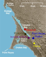
. It is located on the northeast shore of Tomales Bay
6 miles (9.7 km) south of Tomales
, at an elevation of 23 feet (7 m).
Marshall is located on the east shore of Tomales Bay
. It has a population of about 400, although it has long claimed a population of 50 and touted this as the sum of the elevation (15 feet or 4.5 m above sea level
) and the speed limit of 35 miles per hour (56 km/h). It is located approximately 15 miles (24 km) south east of Bodega Bay
, on State Route 1
. Its ZIP code
is 94940.
The town is named after four brothers called Marshall, who set up a dairying industry there in the 1850s. Starting in the 1870s, Marshall was a stop on the North Pacific Coast Railroad
connecting Cazadero
to the Sausalito
ferry.
There is still some dairying in the area, but nowadays the town's major commerce is in oyster
s and clam
s, for which it is a center. It also acts as a center for tourists
visiting Tomales Bay
and the neighbouring Point Reyes Peninsula.
Unincorporated area
In law, an unincorporated area is a region of land that is not a part of any municipality.To "incorporate" in this context means to form a municipal corporation, a city, town, or village with its own government. An unincorporated community is usually not subject to or taxed by a municipal government...
in Marin County
Marin County, California
Marin County is a county located in the North San Francisco Bay Area of the U.S. state of California, across the Golden Gate Bridge from San Francisco. As of 2010, the population was 252,409. The county seat is San Rafael and the largest employer is the county government. Marin County is well...
, California
California
California is a state located on the West Coast of the United States. It is by far the most populous U.S. state, and the third-largest by land area...
. It is located on the northeast shore of Tomales Bay
Tomales Bay
Tomales Bay is a long narrow inlet of the Pacific Ocean in Marin County in northern California in the United States. It is approximately 15 miles long and averages nearly 1.0 miles wide, effectively separating the Point Reyes Peninsula from the mainland of Marin County. It is located...
6 miles (9.7 km) south of Tomales
Tomales, California
Tomales is a census-designated place on State Route 1 in Marin County, California, United States. The population was 204 at the 2010 census. The largest employer in Tomales is Tomales High School, which has a student body of approximately 250.-Geography:Tomales is located above Keys Creek,...
, at an elevation of 23 feet (7 m).
Marshall is located on the east shore of Tomales Bay
Tomales Bay
Tomales Bay is a long narrow inlet of the Pacific Ocean in Marin County in northern California in the United States. It is approximately 15 miles long and averages nearly 1.0 miles wide, effectively separating the Point Reyes Peninsula from the mainland of Marin County. It is located...
. It has a population of about 400, although it has long claimed a population of 50 and touted this as the sum of the elevation (15 feet or 4.5 m above sea level
Sea level
Mean sea level is a measure of the average height of the ocean's surface ; used as a standard in reckoning land elevation...
) and the speed limit of 35 miles per hour (56 km/h). It is located approximately 15 miles (24 km) south east of Bodega Bay
Bodega Bay
Bodega Bay is a shallow, rocky inlet of the Pacific Ocean on the coast of northern California in the United States. It is approximately across and is located approximately northwest of San Francisco and west of Santa Rosa...
, on State Route 1
California State Route 1
State Route 1 , more often called Highway 1, is a state highway that runs along much of the Pacific coast of the U.S. state of California. It is famous for running along some of the most beautiful coastlines in the world, leading to its designation as an All-American Road.Highway 1 does not run...
. Its ZIP code
ZIP Code
ZIP codes are a system of postal codes used by the United States Postal Service since 1963. The term ZIP, an acronym for Zone Improvement Plan, is properly written in capital letters and was chosen to suggest that the mail travels more efficiently, and therefore more quickly, when senders use the...
is 94940.
The town is named after four brothers called Marshall, who set up a dairying industry there in the 1850s. Starting in the 1870s, Marshall was a stop on the North Pacific Coast Railroad
North Pacific Coast Railroad
The North Pacific Coast Railroad was a common carrier narrow gauge steam railroad begun in 1874 and sold in 1902 to new owners who renamed it the North Shore Railroad and which rebuilt the southern section into a standard gauge electric railroad.The NPC operated in the northern California...
connecting Cazadero
Cazadero, California
Cazadero is an unincorporated town and census-designated place in western Sonoma County, California, United States with a population of 354 as of the 2010 Census. Nearby towns include Jenner, Annapolis, Stewart's Point, Duncans Mills, Villa Grande, Rio Nido, Guerneville, Monte Rio, and The Sea Ranch...
to the Sausalito
Sausalito, California
Sausalito is a San Francisco Bay Area city, in Marin County, California, United States. Sausalito is south-southeast of San Rafael, at an elevation of 13 feet . The population was 7,061 as of the 2010 census. The community is situated near the northern end of the Golden Gate Bridge, and prior to...
ferry.
There is still some dairying in the area, but nowadays the town's major commerce is in oyster
Oyster
The word oyster is used as a common name for a number of distinct groups of bivalve molluscs which live in marine or brackish habitats. The valves are highly calcified....
s and clam
Clam
The word "clam" can be applied to freshwater mussels, and other freshwater bivalves, as well as marine bivalves.In the United States, "clam" can be used in several different ways: one, as a general term covering all bivalve molluscs...
s, for which it is a center. It also acts as a center for tourists
Tourism
Tourism is travel for recreational, leisure or business purposes. The World Tourism Organization defines tourists as people "traveling to and staying in places outside their usual environment for not more than one consecutive year for leisure, business and other purposes".Tourism has become a...
visiting Tomales Bay
Tomales Bay
Tomales Bay is a long narrow inlet of the Pacific Ocean in Marin County in northern California in the United States. It is approximately 15 miles long and averages nearly 1.0 miles wide, effectively separating the Point Reyes Peninsula from the mainland of Marin County. It is located...
and the neighbouring Point Reyes Peninsula.
External links
- Information and photographs about Marshall on the Beach California website
- Information about Marshall on the West Marin Chamber of Commerce website