
Mapo-gu
Encyclopedia
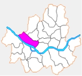
Mapo-gu is a gu, or district, within Seoul
, South Korea
. It lies northwest of the Han River
. Several universities and government buildings are located here. Mapo is especially well-known for the Hongdae club district around Hongik University
. Seoul Metropolitan Subway
Line 1
, Line 5
, and Line 6
pass through this district. The Seoul World Cup Stadium
, a famous landmark in Seoul, is located Sangam town in northwest Mapo. Neighboring districts include Yongsan-gu
, Jung-gu
, Seodaemun-gu
and Eunpyeong-gu
.
and Yongsan-gu
. The dong structure was revised in 1985 and 2008.
Roughly 53% of Mapo-gu's area is taken up by residences, many of which are high-rise apartment buildings. Much of the remaining area (43%) is greenspace, including the World Cup Park and additional parkland along the Han River.
Mapo-gu recently revamped its precincts (2008). The revision aimed to merge some precincts into one big precincts. This effectively reduces number of administrative office for precincts. As a result, the number of precinct offices decreased to 16 from 24. However, the administrative revamp did not change the address system. For example, let us suppose you live in Changjeon precinct. This precinct is now merged to Sogang precinct. The precinct name in your address is still retained as Changjeon precinct.
These are the regular address precincts:
These are the revamped administrative precincts:
and Hongik University
, are active in Mapo-gu. The area around Hongik University is also well-known as one of the cultural centers of Seoul. There are eight high schools, including Seoul Girls' High School
, along with 12 middle schools and 20 elementary schools serving the community. There are three special schools for handicapped or industrial educations. Due to the presence of university students in the district, Mapo-gu offers a large variety of shopping and dining options. The area around Ewha Women's University is known for its affordable yet trendy merchandise, while neighboring Shinchon has an enormous number of take out and sit down restaurants.
Seoul
Seoul , officially the Seoul Special City, is the capital and largest metropolis of South Korea. A megacity with a population of over 10 million, it is the largest city proper in the OECD developed world...
, South Korea
South Korea
The Republic of Korea , , is a sovereign state in East Asia, located on the southern portion of the Korean Peninsula. It is neighbored by the People's Republic of China to the west, Japan to the east, North Korea to the north, and the East China Sea and Republic of China to the south...
. It lies northwest of the Han River
Han River (Korea)
The Han River is a major river in South Korea and the fourth longest river on the Korean peninsula after the Amnok, Duman, and Nakdong rivers. It is formed by the confluence of the Namhan River , which originates in Mount Daedeok, and the Bukhan River , which originates on the slopes of Mount...
. Several universities and government buildings are located here. Mapo is especially well-known for the Hongdae club district around Hongik University
Hongik University
Hongik University, usually known as "Hongdae" for short, is a private university in the Mapo-gu district of central Seoul, South Korea with a second campus in Jochiwon, Chungcheongnam-do. Hongik University offers a comprehensive range of undergraduate and graduate programs...
. Seoul Metropolitan Subway
Seoul Metropolitan Subway
The Seoul Metropolitan Subway or Metropolitan Subway in Seoul, in Seoul, South Korea, is one of the most heavily used rapid transit systems in the world, with well over 8 million trips daily on the system's thirteen lines...
Line 1
Seoul Subway Line 1
Seoul Subway Line 1 of the Seoul Metropolitan Subway, formerly known as the Korea National Railroad of Seoul, is an operation channel which links central Seoul, South Korea to Soyosan Station in the northeast, Incheon in the southwest, and Asan via Suwon in the south. This line covers a large part...
, Line 5
Seoul Subway Line 5
Seoul Subway Line 5 of the Seoul Metropolitan Rapid Transit Corporation, dubbed the purple line, is a long line crossing from the west to the east across the Seoul National Capital Area, South Korea...
, and Line 6
Seoul Subway Line 6
Seoul Subway Line 6 is a line of the Seoul Subway. Its color is brown.-Overview:The route connects Eunpyeong-gu and Jungnang-gu in an U-shaped manner, running through Yongsan-gu and Seongbuk-gu. It does not cross over the Han River...
pass through this district. The Seoul World Cup Stadium
Seoul World Cup Stadium
The Seoul World Cup Stadium, also known as Sangam Stadium, is located in Seongsan, Mapo-gu, Seoul, South Korea. It was built for the 2002 FIFA World Cup and opened in 2001. It was designed to represent the image of a traditional Korean kite...
, a famous landmark in Seoul, is located Sangam town in northwest Mapo. Neighboring districts include Yongsan-gu
Yongsan-gu
Yongsan-gu is a district of Seoul, South Korea. Its name means "Dragon Hill", derived from the hanja characters for dragon and hill/mountain . It sits to the North of the Han River under the shadow of Seoul Tower. Geographically, it is located right in the center of Seoul. It is home to roughly...
, Jung-gu
Jung-gu, Seoul
Jung-gu is one of the 25 gu which make up the city of Seoul, South Korea. It is located on the north side of the Han River, and is the historical center of the city .-Overview:...
, Seodaemun-gu
Seodaemun-gu
Seodaemun-gu is a gu located in northwestern Seoul, South Korea. The name derives from Seodaemun, meaning literally "Great West Gate", which was once located in the district...
and Eunpyeong-gu
Eunpyeong-gu
Eunpyeong-gu is one of the 25 gu which make up the city of Seoul, South Korea.The mayor of this district is Jaedong NOH since July 2006.-Administrative divisions:*Bulgwang-dong *Daejo-dong *Eungam-dong...
.
Location
Mapo District Office is located in Seongsan-1 precinct, near World Cup Stadium (15 minutes on foot). Seoul Metropolitan Subway Line 6 passes near the office, and it has a station name "Mapo District Office" 200 m south of the office.Organization
The district office has 5 Divisions, 24 Departments, 3 Special Assistance Teams. Mapo District Office employs total 1,298 personnels. The entire office is headed by Administrator. Current Administrator is Youngsub Shin (2008).Administrative divisions
Mapo-gu was formed in 1944 from portions of Seodaemun-guSeodaemun-gu
Seodaemun-gu is a gu located in northwestern Seoul, South Korea. The name derives from Seodaemun, meaning literally "Great West Gate", which was once located in the district...
and Yongsan-gu
Yongsan-gu
Yongsan-gu is a district of Seoul, South Korea. Its name means "Dragon Hill", derived from the hanja characters for dragon and hill/mountain . It sits to the North of the Han River under the shadow of Seoul Tower. Geographically, it is located right in the center of Seoul. It is home to roughly...
. The dong structure was revised in 1985 and 2008.
Roughly 53% of Mapo-gu's area is taken up by residences, many of which are high-rise apartment buildings. Much of the remaining area (43%) is greenspace, including the World Cup Park and additional parkland along the Han River.
Mapo-gu recently revamped its precincts (2008). The revision aimed to merge some precincts into one big precincts. This effectively reduces number of administrative office for precincts. As a result, the number of precinct offices decreased to 16 from 24. However, the administrative revamp did not change the address system. For example, let us suppose you live in Changjeon precinct. This precinct is now merged to Sogang precinct. The precinct name in your address is still retained as Changjeon precinct.
These are the regular address precincts:
|
|
These are the revamped administrative precincts:
|
Sinsu-dong Sinsu-dong is a dong, neighbourhood of the Mapo-gu district in Seoul, South Korea.-External links:* * at the Mapo-gu official website at the Mapo-gu official website... (신수동; 新水洞) Yeomni-dong Yeomni-dong is a dong, neighbourhood of the Mapo-gu district in Seoul, South Korea.-External links:* * at the Mapo-gu official website at the Mapo-gu official website... (염리동; 鹽里洞) Yeonnam-dong Yeonnam-dong is a dong, neighbourhood of the Mapo-gu district in Seoul, South Korea.-External links:* * at the Mapo-gu official website at the Mapo-gu official website... (연남동; 延南洞) Mangwon-dong Mangwon-dong is a dong, or neighbourhood of the Mapo-gu district in Seoul, South Korea.-External links:* * at the Mapo-gu official website at the Mapo-gu official website... (망원1동; 望遠1洞) Mangwon-dong Mangwon-dong is a dong, or neighbourhood of the Mapo-gu district in Seoul, South Korea.-External links:* * at the Mapo-gu official website at the Mapo-gu official website... (망원2동; 望遠2洞) Seongsan-dong Seongsan-dong is a dong, neighbourhood of the Mapo-gu district in Seoul, South Korea.-External links:* * at the Mapo-gu official website at the Mapo-gu official website... (성산1동; 城山1洞) Seongsan-dong Seongsan-dong is a dong, neighbourhood of the Mapo-gu district in Seoul, South Korea.-External links:* * at the Mapo-gu official website at the Mapo-gu official website... (성산2동; 城山2洞) Sangam-dong Sangam-dong is a legal dong, neighbourhood of the Mapo-gu district in Seoul, South Korea.-Attractions:*Nanjido *Worldcup Park **Millennium Park **Sky Park **Pyeonghwa Park **Noeul Park... (상암동; 上岩洞) |
Origin of the name
The name "Mapo" comes from the name of an old ferry across the Han River, and can roughly be translated as "hemp ferry."Education
Four college or university institutions, such as Sogang UniversitySogang University
Sogang University is one of the leading research and liberal arts universities in Seoul, South Korea.The University was established in 1960 by the Society of Jesus to provide education based on the Catholic beliefs and inspired by the Jesuit educational philosophy, such as Georgetown University in...
and Hongik University
Hongik University
Hongik University, usually known as "Hongdae" for short, is a private university in the Mapo-gu district of central Seoul, South Korea with a second campus in Jochiwon, Chungcheongnam-do. Hongik University offers a comprehensive range of undergraduate and graduate programs...
, are active in Mapo-gu. The area around Hongik University is also well-known as one of the cultural centers of Seoul. There are eight high schools, including Seoul Girls' High School
Seoul Girls' High School
Seoul Girls' High School is a high school in Mapo district, Seoul, South Korea. It was established in 1958 as Mapo Girls' High School, and took its present name in 1960. The school was divided into separate junior high and high schools in 1968....
, along with 12 middle schools and 20 elementary schools serving the community. There are three special schools for handicapped or industrial educations. Due to the presence of university students in the district, Mapo-gu offers a large variety of shopping and dining options. The area around Ewha Women's University is known for its affordable yet trendy merchandise, while neighboring Shinchon has an enormous number of take out and sit down restaurants.