
,_new_york.gif)
Manlius (village), New York
Encyclopedia
Manlius is a village in Onondaga County, New York
, USA. The population was 4,819 at the 2000 census. The village takes its name from its town.
The Village of Manlius is near the south town line of the Town of Manlius
and is southeast of the City of Syracuse
of which it is a suburb
.
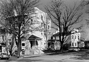
An area of about 3 blocks in size within the village, running along Seneca Street and parallel Pleasant Street, is listed on the National Register of Historic Places
as the Manlius Village Historic District
.
 Originally one of the communities in the Central New York Military Tract
(defined as Township Number Seven), the town of Manlius was settled in 1794. The village, however was settled two years before by John A. Shaeffer, a German. The first schoolhouse in Manlius was erected in 1798. Made out of logs, it was located near a local resident's mill, named only as Mr. Costello. By 1801, the village began to grow, with six buildings, and several amenities including a blacksmith, store, doctor, lawyer, and a tavern. By the turn of the 19th century, there was also a post office defined as "Liberty Square". However, the name of Liberty Square was eventually renamed to Manlius Square. After four years, Manlius had grown at a rapid rate, with the building of thirty houses. The growing village was defined as one of the most promienent business locations in Onondaga County. + The community became the first village in the county in 1813.
Before the construction of the Erie Canal
, Manlius was a large business point along the Cherry Valley Turnpike and Seneca Turnpikes. Since the travelling of goods passed through Manlius on these turnpikes, that every other structure along the highways were taverns. Between Manlius and nearby Chittenango, New York
, there were only about six or seven public buildings. Most of this stretch of the Seneca Turnpike is now New York State Route 173
.
For twenty years, Manlius was the biggest trade center in Onondaga County, with what is now Syracuse, New York
a swamp at the time. Into the early 20th century, its St. John Military Academy was a respected private school for young men.
According to the United States Census Bureau
, the village has a total area of 1.8 square miles (4.6 km²).None of the area is covered with water.
New York State Route 92
and New York State Route 173
intersect in Manlius.
of 2000, there were 4,819 people, 2,056 households, and 1,293 families residing in the village. The population density
was 2,705.8 people per square mile (1,045.3/km²). There were 2,143 housing units at an average density of 1,203.3 per square mile (464.8/km²). The racial makeup of the village was 93.07% White, 1.02% Black or African American
, 0.23% Native American, 4.17% Asian, 0.21% from other races
, and 1.31% from two or more races. Hispanic or Latino of any race were 1.31% of the population.
There were 2,056 households out of which 32.6% had children under the age of 18 living with them, 51.8% were married couples living together, 9.0% had a female householder with no husband present, and 37.1% were non-families. 33.2% of all households were made up of individuals and 15.6% had someone living alone who was 65 years of age or older. The average household size was 2.33 and the average family size was 3.00.
In the village the population was spread out with 26.7% under the age of 18, 4.8% from 18 to 24, 27.7% from 25 to 44, 24.5% from 45 to 64, and 16.3% who were 65 years of age or older. The median age was 39 years. For every 100 females there were 87.2 males. For every 100 females age 18 and over, there were 79.8 males.
The median income for a household in the village was $45,492, and the median income for a family was $65,080. Males had a median income of $49,600 versus $29,118 for females. The per capita income
for the village was $26,434. About 3.2% of families and 6.4% of the population were below the poverty line, including 10.5% of those under age 18 and 7.2% of those age 65 or over.
education is served by the Fayetteville-Manlius Central School District
.
Onondaga County, New York
Onondaga County is a county located in the U.S. state of New York. As of the 2010 census, the population was 467,026. The county seat is Syracuse.Onondaga County is part of the Syracuse, NY Metropolitan Statistical Area....
, USA. The population was 4,819 at the 2000 census. The village takes its name from its town.
The Village of Manlius is near the south town line of the Town of Manlius
Manlius (town), New York
Manlius is a town in Onondaga County, east of the city of Syracuse, New York, United States. The population was 32,370 at the 2010 census, making it the third largest suburb in metropolitan Syracuse...
and is southeast of the City of Syracuse
Syracuse, New York
Syracuse is a city in and the county seat of Onondaga County, New York, United States, the largest U.S. city with the name "Syracuse", and the fifth most populous city in the state. At the 2010 census, the city population was 145,170, and its metropolitan area had a population of 742,603...
of which it is a suburb
Suburb
The word suburb mostly refers to a residential area, either existing as part of a city or as a separate residential community within commuting distance of a city . Some suburbs have a degree of administrative autonomy, and most have lower population density than inner city neighborhoods...
.
An area of about 3 blocks in size within the village, running along Seneca Street and parallel Pleasant Street, is listed on the National Register of Historic Places
National Register of Historic Places
The National Register of Historic Places is the United States government's official list of districts, sites, buildings, structures, and objects deemed worthy of preservation...
as the Manlius Village Historic District
Manlius Village Historic District
The Manlius Village Historic District is a historic district on the east side of the village of Manlius, in the town of Manlius, New York, about 9.5 miles from the downtown of Syracuse....
.
History
Central New York Military Tract
The Military Tract of Central New York, also called the New Military Tract, consisted of nearly two million acres of bounty land set aside to compensate New York’s soldiers after their participation in the Revolutionary War....
(defined as Township Number Seven), the town of Manlius was settled in 1794. The village, however was settled two years before by John A. Shaeffer, a German. The first schoolhouse in Manlius was erected in 1798. Made out of logs, it was located near a local resident's mill, named only as Mr. Costello. By 1801, the village began to grow, with six buildings, and several amenities including a blacksmith, store, doctor, lawyer, and a tavern. By the turn of the 19th century, there was also a post office defined as "Liberty Square". However, the name of Liberty Square was eventually renamed to Manlius Square. After four years, Manlius had grown at a rapid rate, with the building of thirty houses. The growing village was defined as one of the most promienent business locations in Onondaga County. + The community became the first village in the county in 1813.
Before the construction of the Erie Canal
Erie Canal
The Erie Canal is a waterway in New York that runs about from Albany, New York, on the Hudson River to Buffalo, New York, at Lake Erie, completing a navigable water route from the Atlantic Ocean to the Great Lakes. The canal contains 36 locks and encompasses a total elevation differential of...
, Manlius was a large business point along the Cherry Valley Turnpike and Seneca Turnpikes. Since the travelling of goods passed through Manlius on these turnpikes, that every other structure along the highways were taverns. Between Manlius and nearby Chittenango, New York
Chittenango, New York
Chittenango is a village located in Madison County, New York, in the United States. The village is in the south part of the Town of Sullivan. The population was 5,081 at the 2010 census.- History :...
, there were only about six or seven public buildings. Most of this stretch of the Seneca Turnpike is now New York State Route 173
New York State Route 173
New York State Route 173 is a state highway located in the Syracuse area of central New York, United States. It takes a slightly bow-shaped route from NY 31 in the town of Van Buren to NY 5 in Chittenango, gently curving to the south of Downtown Syracuse in the center of its routing...
.
For twenty years, Manlius was the biggest trade center in Onondaga County, with what is now Syracuse, New York
Syracuse, New York
Syracuse is a city in and the county seat of Onondaga County, New York, United States, the largest U.S. city with the name "Syracuse", and the fifth most populous city in the state. At the 2010 census, the city population was 145,170, and its metropolitan area had a population of 742,603...
a swamp at the time. Into the early 20th century, its St. John Military Academy was a respected private school for young men.
Geography
Manlius is located at 43°0′8"N 75°58′44"W (43.002266, -75.979068).According to the United States Census Bureau
United States Census Bureau
The United States Census Bureau is the government agency that is responsible for the United States Census. It also gathers other national demographic and economic data...
, the village has a total area of 1.8 square miles (4.6 km²).None of the area is covered with water.
New York State Route 92
New York State Route 92
New York State Route 92 is a state highway located in central New York in the United States. The western terminus of the route is at an intersection with U.S. Route 11 in downtown Syracuse. Its eastern terminus is at a junction with US 20 west of the village of Cazenovia...
and New York State Route 173
New York State Route 173
New York State Route 173 is a state highway located in the Syracuse area of central New York, United States. It takes a slightly bow-shaped route from NY 31 in the town of Van Buren to NY 5 in Chittenango, gently curving to the south of Downtown Syracuse in the center of its routing...
intersect in Manlius.
Demographics
As of the censusCensus
A census is the procedure of systematically acquiring and recording information about the members of a given population. It is a regularly occurring and official count of a particular population. The term is used mostly in connection with national population and housing censuses; other common...
of 2000, there were 4,819 people, 2,056 households, and 1,293 families residing in the village. The population density
Population density
Population density is a measurement of population per unit area or unit volume. It is frequently applied to living organisms, and particularly to humans...
was 2,705.8 people per square mile (1,045.3/km²). There were 2,143 housing units at an average density of 1,203.3 per square mile (464.8/km²). The racial makeup of the village was 93.07% White, 1.02% Black or African American
Race (United States Census)
Race and ethnicity in the United States Census, as defined by the Federal Office of Management and Budget and the United States Census Bureau, are self-identification data items in which residents choose the race or races with which they most closely identify, and indicate whether or not they are...
, 0.23% Native American, 4.17% Asian, 0.21% from other races
Race (United States Census)
Race and ethnicity in the United States Census, as defined by the Federal Office of Management and Budget and the United States Census Bureau, are self-identification data items in which residents choose the race or races with which they most closely identify, and indicate whether or not they are...
, and 1.31% from two or more races. Hispanic or Latino of any race were 1.31% of the population.
There were 2,056 households out of which 32.6% had children under the age of 18 living with them, 51.8% were married couples living together, 9.0% had a female householder with no husband present, and 37.1% were non-families. 33.2% of all households were made up of individuals and 15.6% had someone living alone who was 65 years of age or older. The average household size was 2.33 and the average family size was 3.00.
In the village the population was spread out with 26.7% under the age of 18, 4.8% from 18 to 24, 27.7% from 25 to 44, 24.5% from 45 to 64, and 16.3% who were 65 years of age or older. The median age was 39 years. For every 100 females there were 87.2 males. For every 100 females age 18 and over, there were 79.8 males.
The median income for a household in the village was $45,492, and the median income for a family was $65,080. Males had a median income of $49,600 versus $29,118 for females. The per capita income
Per capita income
Per capita income or income per person is a measure of mean income within an economic aggregate, such as a country or city. It is calculated by taking a measure of all sources of income in the aggregate and dividing it by the total population...
for the village was $26,434. About 3.2% of families and 6.4% of the population were below the poverty line, including 10.5% of those under age 18 and 7.2% of those age 65 or over.
Education
Public K-12K-12
K–12 is a designation for the sum of primary and secondary education. It is used in the United States, Canada, Australia, and New Zealand where P–12 is also commonly used...
education is served by the Fayetteville-Manlius Central School District
Fayetteville-Manlius Central School District
The Fayetteville-Manlius Central School District is a K-12 public school district located in the Town of Manlius in Central New York, enrolling approximately 4,800 students. F-M serves a large portion of the Town of Manlius, including the villages of Manlius and Fayetteville, as well as portions...
.