
Manitoulin District, Ontario
Encyclopedia
Manitoulin District is a district in Northeastern Ontario
within the Canadian
province
of Ontario
. It was created in 1888 from part of Algoma District
. The district seat is Gore Bay
.
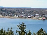
It comprises Manitoulin Island
and a number of small islands around it, making it the smallest district in Ontario. Previously it included the municipality of Killarney
on the mainland, until this was transferred to Sudbury District
in the late 1990s. However, the district still includes a small mainland portion which is part of the Wikwemikong Unceded Indian Reserve
.
of 2.8 people/km (1.7 people/mi). There are no visible minorities in the district; however, almost 40 per cent of the district's population is First Nations
.
or regional municipality
tier of municipal government. All services in the district are provided either by the individual municipalities or directly by the provincial government. However, the Manitoulin District does not have its own administrative area for provincial government services — instead, services are provided jointly with the Sudbury District
from its district seat in Espanola
.
. This highway enters the district at the ferry docks in South Baymouth, in the township of Tehkummah, where the Chi-Cheemaun
ferry travels to and from Tobermory in the municipality of Northern Bruce Peninsula
. It exits the district in the Whitefish River First Nation, just south of Whitefish Falls, when it crosses into the Sudbury District
.
A number of secondary provincial highways, the equivalent in a district to a county or municipal road in Southern Ontario, serve the communities of Manitoulin Island. These are:
Religious groups
Northeastern Ontario
Northeastern Ontario is the region within the Canadian province of Ontario which lies north and east of Lakes Superior and Huron.Northeastern Ontario consists of the districts of Algoma, Sudbury, Cochrane, Timiskaming, Nipissing and Manitoulin; and the single-tier municipality of Greater...
within the Canadian
Canada
Canada is a North American country consisting of ten provinces and three territories. Located in the northern part of the continent, it extends from the Atlantic Ocean in the east to the Pacific Ocean in the west, and northward into the Arctic Ocean...
province
Provinces and territories of Canada
The provinces and territories of Canada combine to make up the world's second-largest country by area. There are ten provinces and three territories...
of Ontario
Ontario
Ontario is a province of Canada, located in east-central Canada. It is Canada's most populous province and second largest in total area. It is home to the nation's most populous city, Toronto, and the nation's capital, Ottawa....
. It was created in 1888 from part of Algoma District
Algoma District, Ontario
Algoma District is a district and census division in Northeastern Ontario in the Canadian province of Ontario. It was created in 1858 comprising territory as far west as Minnesota...
. The district seat is Gore Bay
Gore Bay, Ontario
Gore Bay is a town on Manitoulin Island in Ontario, Canada. Located on Gore Bay, a bay of Lake Huron's North Channel, it is one of the two incorporated towns of Manitoulin District....
.
It comprises Manitoulin Island
Manitoulin Island
Manitoulin Island is a Canadian island in Lake Huron, in the province of Ontario. It is the largest island in a freshwater lake in the world. In addition to the historic Anishinaabe and European settlement of the island, archeological discoveries at Sheguiandah have demonstrated Paleo-Indian and...
and a number of small islands around it, making it the smallest district in Ontario. Previously it included the municipality of Killarney
Killarney, Ontario
Killarney is a municipality located on the northern shore of Georgian Bay in the Sudbury District of Ontario. It is also the name of the largest community within the municipality...
on the mainland, until this was transferred to Sudbury District
Sudbury District, Ontario
The Sudbury District is a district in Northeastern Ontario in the Canadian province of Ontario. It was created in 1894 from townships of eastern Algoma District and west Nipissing District....
in the late 1990s. However, the district still includes a small mainland portion which is part of the Wikwemikong Unceded Indian Reserve
Wikwemikong Unceded Indian Reserve
Wikwemikong Unceded Indian Reserve is an Indian reserve in the north-eastern section of Manitoulin Island in Manitoulin District, Ontario, Canada...
.
Demographics
In 2001, the population of Manitoulin District was 12,679; in 2006, it had risen to 13,090. The district's land area is 4,759.74 km (2,957 mi), for a population densityPopulation density
Population density is a measurement of population per unit area or unit volume. It is frequently applied to living organisms, and particularly to humans...
of 2.8 people/km (1.7 people/mi). There are no visible minorities in the district; however, almost 40 per cent of the district's population is First Nations
First Nations
First Nations is a term that collectively refers to various Aboriginal peoples in Canada who are neither Inuit nor Métis. There are currently over 630 recognised First Nations governments or bands spread across Canada, roughly half of which are in the provinces of Ontario and British Columbia. The...
.
Services
Like the other districts of Northern Ontario, the Manitoulin District does not have a countyCounty
A county is a jurisdiction of local government in certain modern nations. Historically in mainland Europe, the original French term, comté, and its equivalents in other languages denoted a jurisdiction under the sovereignty of a count A county is a jurisdiction of local government in certain...
or regional municipality
Regional municipality
A regional municipality is a type of Canadian municipal government similar to and at the same municipal government level as a county, although the specific structure and servicing responsibilities may vary from place to place...
tier of municipal government. All services in the district are provided either by the individual municipalities or directly by the provincial government. However, the Manitoulin District does not have its own administrative area for provincial government services — instead, services are provided jointly with the Sudbury District
Sudbury District, Ontario
The Sudbury District is a district in Northeastern Ontario in the Canadian province of Ontario. It was created in 1894 from townships of eastern Algoma District and west Nipissing District....
from its district seat in Espanola
Espanola, Ontario
Espanola is a town in Northern Ontario, Canada, and is the seat of Sudbury District. It is situated on the Spanish River, approximately 70 kilometres west of downtown Sudbury, and just south of the junction of Highway 6 and Highway 17.- History :The name "Espanola" has been attributed to a story...
.
Organizations
- Manitoulin Streams Improvement AssociationManitoulin Streams Improvement AssociationManitoulin Streams Improvement Association is a not for profit group that rehabilitates streams, rivers and creeks on the largest freshwater island in the world Manitoulin Island, Ontario, Canada. They partner with the entire community, including farmers, fisherman, and local lake and fish...
- A not for profit group that rehabilitates streams rivers and creeks on Manitoulin Island.
Towns
- Gore BayGore Bay, OntarioGore Bay is a town on Manitoulin Island in Ontario, Canada. Located on Gore Bay, a bay of Lake Huron's North Channel, it is one of the two incorporated towns of Manitoulin District....
- Northeastern Manitoulin and the IslandsNortheastern Manitoulin and the Islands, OntarioNortheastern Manitoulin and the Islands is a municipality with "town" status in Manitoulin District in Northeastern Ontario, Canada, approximately 30 kilometres south of Espanola. Its main town is Little Current, located on the northeast side of Manitoulin Island...
Townships
- AssiginackAssiginack, OntarioAssiginack is a township in the Canadian province of Ontario, located on Manitoulin Island. An Ontario Historical Plaque was erected on the grounds of the Assiginack Museum by the province to commemorate the Manitoulin Treaties' role in Ontario's heritage...
- BillingsBillings, OntarioBillings is a township in the Canadian province of Ontario, as well as the name of a community within that township.Located in the Manitoulin District, the township had a population of 539 in the Canada 2006 Census.-Communities:...
- Burpee and MillsBurpee and Mills, OntarioBurpee and Mills is a township in the Canadian province of Ontario. The township comprises the communities of Burpee, Elizabeth Bay, Evansville and Poplar....
- Central ManitoulinCentral Manitoulin, OntarioCentral Manitoulin is a township in the Canadian province of Ontario. It is located on Manitoulin Island and in Manitoulin District.The primary community and administrative centre of the township is Mindemoya...
- Cockburn Island
- Gordon/Barrie IslandGordon/Barrie IslandThe Municipality of Gordon/Barrie Island is a township in Manitoulin District in north central Ontario, Canada. It was formed on January 1, 2009 upon the amalgamation of the townships of Gordon and Barrie Island....
- TehkummahTehkummah, OntarioTehkummah is a township in the Canadian province of Ontario, located on Manitoulin Island. The township had a population of 382 in the Canada 2006 Census.-Communities:...
Unorganized areas
- Manitoulin, Unorganized, MainlandManitoulin, Unorganized, Mainland, OntarioUnorganized Mainland Manitoulin is an unorganized area in the Canadian province of Ontario, encompassing the small mainland portion of the Manitoulin District which is not part of the municipality of Killarney...
- Manitoulin, Unorganized, West PartManitoulin, Unorganized, West Part, OntarioManitoulin, Unorganized West Part is an unorganized area in Manitoulin District in northeastern Ontario, Canada, encompassing the portion of Manitoulin Island which is not part of an organized municipality...
Indian reserves
- M'Chigeeng (West Bay)
- Sheguiandah
- Sheshegwaning
- Sucker Creek
- Whitefish River
- Wikwemikong
- Zhiibaahaasing (Cockburn Island)
Provincial highways
Manitoulin District is served by only one primary provincial highway, Highway 6Highway 6 (Ontario)
King's Highway 6, also known as Highway 6, is a provincially maintained highway in the Canadian province of Ontario. It crosses a distance of between Port Dover on the north shore of Lake Erie and Espanola on the northern shore of Lake Huron, ending at the Trans-Canada Highway in McKerrow.- Port...
. This highway enters the district at the ferry docks in South Baymouth, in the township of Tehkummah, where the Chi-Cheemaun
Chi-Cheemaun
MS Chi-Cheemaun is a passenger and car ferry in Ontario, Canada, which traverses Lake Huron between Tobermory on Bruce Peninsula and South Baymouth on Manitoulin Island. The ferry connects the two geographically separate portions of Highway 6 and is the vessel that replaced MS Norgoma and SS...
ferry travels to and from Tobermory in the municipality of Northern Bruce Peninsula
Northern Bruce Peninsula, Ontario
The Municipality of Northern Bruce Peninsula is located on the Bruce Peninsula in Ontario, Canada. It is a popular vacation spot in the summer for its water sports and cottaging and in the winter for the snowmobiling....
. It exits the district in the Whitefish River First Nation, just south of Whitefish Falls, when it crosses into the Sudbury District
Sudbury District, Ontario
The Sudbury District is a district in Northeastern Ontario in the Canadian province of Ontario. It was created in 1894 from townships of eastern Algoma District and west Nipissing District....
.
A number of secondary provincial highways, the equivalent in a district to a county or municipal road in Southern Ontario, serve the communities of Manitoulin Island. These are:
| Highway | Extension |
|---|---|
| 540 | from the community of Little Current (Northeastern Manitoulin and the Islands Northeastern Manitoulin and the Islands, Ontario Northeastern Manitoulin and the Islands is a municipality with "town" status in Manitoulin District in Northeastern Ontario, Canada, approximately 30 kilometres south of Espanola. Its main town is Little Current, located on the northeast side of Manitoulin Island... ) to Meldrum Bay, the westernmost settlement on the island |
| 540A | connects Barrie Island to Highway 540 |
| 540B | connects Gore Bay Gore Bay, Ontario Gore Bay is a town on Manitoulin Island in Ontario, Canada. Located on Gore Bay, a bay of Lake Huron's North Channel, it is one of the two incorporated towns of Manitoulin District.... to Highway 540 |
| 542 | extends from Highway 540 south of Gore Bay to Highway 6 near Tehkummah |
| 542A | connects the community of Tehkummah to Highway 542 |
| 551 | from M'Chigeeng (West Bay) to Providence Bay (Central Manitoulin Central Manitoulin, Ontario Central Manitoulin is a township in the Canadian province of Ontario. It is located on Manitoulin Island and in Manitoulin District.The primary community and administrative centre of the township is Mindemoya... ) |
Demographics
Ethnic groups- 62.4% WhiteWhite peopleWhite people is a term which usually refers to human beings characterized, at least in part, by the light pigmentation of their skin...
- 38.0% AboriginalAboriginal peoples in CanadaAboriginal peoples in Canada comprise the First Nations, Inuit and Métis. The descriptors "Indian" and "Eskimo" have fallen into disuse in Canada and are commonly considered pejorative....
- According to Statcan there are no visible minorities in the district, rare for a community in Ontario.
Religious groups
- 42.3% Protestant
- 37.3% Roman Catholic
- 2.7% other Christian
- 17.7% other/none