

Malpasset
Encyclopedia
Dam
A dam is a barrier that impounds water or underground streams. Dams generally serve the primary purpose of retaining water, while other structures such as floodgates or levees are used to manage or prevent water flow into specific land regions. Hydropower and pumped-storage hydroelectricity are...
on the Reyran River, constructed approximately 7 km north of Fréjus
Fréjus
Fréjus is a commune in the Var department in the Provence-Alpes-Côte d'Azur region in southeastern France.It neighbours Saint-Raphaël, effectively forming one town...
on the Côte d'Azur, southern France
France
The French Republic , The French Republic , The French Republic , (commonly known as France , is a unitary semi-presidential republic in Western Europe with several overseas territories and islands located on other continents and in the Indian, Pacific, and Atlantic oceans. Metropolitan France...
, in the Var
Var (département)
The Var is a French department in the region Provence-Alpes-Côte d'Azur in Provence, in southeast France. It takes its name from the river Var, which used to flow along its eastern boundary, but the boundary was moved in 1860...
département. It collapsed on December 2, 1959, killing 421 people in the resulting flood. Various sources indicate death numbers of 361, 400, 423, 429 or 510. The damage amounted to a total of $68 million.
Construction
The dam, which was a doubly curved equal angle arch type with variable radius, began construction in April 1952 and finished in 1954 to supply water and irrigation for the region. Delays due to lack of funding and labor strikes halted construction a few times. Another source reports that construction began as early as 1941. Construction cost 580 million francs (by 1955 prices), and was led by well-known French engineer André CoyneAndre Coyne
André Coyne was a French dam engineer who designed 70 dams in 14 countries. Coyne's creations include the Daniel-Johnson Dam, on the Manicouagan River in Quebec, which is the world's largest multiple-arch dam at 214 meters height and a span of 162 meters.Coyne's first major achievement, which...
. The project was funded and owned by Var
Var (département)
The Var is a French department in the region Provence-Alpes-Côte d'Azur in Provence, in southeast France. It takes its name from the river Var, which used to flow along its eastern boundary, but the boundary was moved in 1860...
département. Concurrent with the dam construction, the A8 autoroute
A8 autoroute
The A8 autoroute, La Provençale, is a -long highway in France between Aix-en-Provence and the A7 to the Côte d'Azur.- Route :The A8 is an extension of the A7 starting to the west of Aix-en-Provence at La Fare-les-Oliviers. The road passes through the Departments of Bouches-du-Rhône, Var and...
was also being built 200 meters away from the dam location.
Disaster
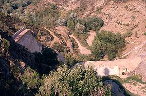
The dam was breached at 21:13 on December 2, 1959. The entire wall collapsed with only a few blocks remaining on the right bank. Pieces of the dam are still scattered throughout the area.The breach created a massive dam break wave, or wall of water, 40 metres (131.2 ft) high and moving at 70 kilometres (43.5 mi) per hour, destroying two small villages - Malpasset and Bozon, the highway construction site, and in 20 minutes reaching Fréjus
Fréjus
Fréjus is a commune in the Var department in the Provence-Alpes-Côte d'Azur region in southeastern France.It neighbours Saint-Raphaël, effectively forming one town...
, still standing 3 metres (10 ft) high. Various small roads and railroad tracks were destroyed as well, water flooding the western half of Fréjus and finally reaching the sea.
Cause
Geological and hydrologic studies were conducted in 1946 and the dam location was considered suitable. Due to lack of proper funding, however, the geological study of the region was not thorough. The lithologyLithology
The lithology of a rock unit is a description of its physical characteristics visible at outcrop, in hand or core samples or with low magnification microscopy, such as colour, texture, grain size, or composition. It may be either a detailed description of these characteristics or be a summary of...
underlying the dam is a metamorphic rock
Metamorphic rock
Metamorphic rock is the transformation of an existing rock type, the protolith, in a process called metamorphism, which means "change in form". The protolith is subjected to heat and pressure causing profound physical and/or chemical change...
called gneiss
Gneiss
Gneiss is a common and widely distributed type of rock formed by high-grade regional metamorphic processes from pre-existing formations that were originally either igneous or sedimentary rocks.-Etymology:...
. This rock type is known to be relatively impermeable
Permeability (fluid)
Permeability in fluid mechanics and the earth sciences is a measure of the ability of a porous material to allow fluids to pass through it.- Units :...
meaning that there is no significant groundwater flow within the rock unit, and it does not allow water to penetrate the ground. On the right side (looking down the river), was also rock, and a concrete wing wall was constructed to connect the wall to the ground.
Weeks before the breach, some cracking noises were observed, but they were not examined. It's hard to determine when the cracking noises started. The right side of the dam had some leaks in November 1959.
A tectonic fault was later found as the most likely cause of the disaster. The water collected under a wall, unable to escape through the rocks. The water pressure was aimed diagonally towards the dam wall, and was not found initially. According to a source, explosions during building of the highway might have caused shifting of the rock base of the dam.
Between November 19th and December 2nd, there was 50cm of rainfall, and 13cm in 24 hours before the breach. The water level in the dam was only 28cm away from the edge. Rain continued, and the dam guardian wanted to open the discharge valves, but the authorities refused, claiming the highway construction site was in danger by flooding water. 5 hours before the breach, at 18:00 hours, the water release valves were opened, but with a discharge rate of 40 m³/s, it was not enough to empty the dam in time.
Until the Malpasset incident, only 4 other incidents of arch-type dam breaches were recorded:
- Manitou dam, Manitou Springs, Colorado, 1924 at 38°52′35.47"N 104°59′38.30"W
- Moyie dam, Moyie Springs, Idaho, 1926 at 48°44′1.28"N 116°10′30.61"W, which is still in use, generating electricity.
- Lake Lanier, North Carolina, 1926
- Purisima dam, California, 1930
See also
- List of natural disasters by death toll - Floods and Landslides
- List of wars and disasters by death toll - Flood disasters
- Sarez Lake
External links
http://www.ecolo.org/documents/documents_in_french/malpasset/malpasset.htmThe Malpasset Catastrophe in 1959 French languageFrench language
French is a Romance language spoken as a first language in France, the Romandy region in Switzerland, Wallonia and Brussels in Belgium, Monaco, the regions of Quebec and Acadia in Canada, and by various communities elsewhere. Second-language speakers of French are distributed throughout many parts...
article with images]
- Cracking of dams
- Chanson, H.Hubert ChansonHubert Chanson is a professor in hydraulic engineering and applied fluid mechanics in the School of Civil Engineering at the University of Queensland since 1990...
(2009) Application of the Method of Characteristics to the Dam Break Wave Problem Journal of Hydraulic Research, IAHR, Vol. 47, No. 1, pp. 41-49 (DOI: 10.3826/jhr.2009.2865) (ISSN 0022-1686) - Website dedicated to the disaster of Malpasset