
Malakula
Encyclopedia
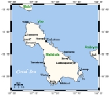
Malakula Island also spelled Malekula, is the second-largest island in the nation of Vanuatu
, in the Pacific Ocean
region of Melanesia
. Its name, coined by James Cook
, is apparently derived from the French
mal au cul (literally, 'pain in the arse') and was inspired by the presence of cannibals, volcanic activity and other unpleasant features of the island at the time of its discovery.
and Malo
by the Bougainville Strait
. Lakatoro
, capital of Malampa Province
, is situated on its eastern shore and is the largest settlement in the island.On the northeastern side of the island there is a group of islands called Small Islands, amongst them (from N to S) Vao, Atchin, Wala (island), Rano, Norsup, Uripiv and Uri (island).
It has a maximum elevation of 879 m. It is called as Mt. Liambele. In 1768, Bougainville
gave his name to the straits which separate Malakula from Santo.
lived on the island taking anthropological notes as well as phononographic and photographic records during his fieldwork. On his return to Britain he donated copies of the more than 400 photographs on plates to the Museum of Archaeology and Anthropology, University of Cambridge
.
There are nearly thirty different languages spoken on the island. The two tribes living are Big Namba
s in the North and the Small Nambas in the central part of the southern area, whose names stem from the size of the penis sheath they wear, made out of banana or pandanus
leaves.
flies to Malekula on every day of the week.
in Bislama language: John Layard long Malakula 1914 - 1915, Vanuatu Cultural Centre
Vanuatu
Vanuatu , officially the Republic of Vanuatu , is an island nation located in the South Pacific Ocean. The archipelago, which is of volcanic origin, is some east of northern Australia, northeast of New Caledonia, west of Fiji, and southeast of the Solomon Islands, near New Guinea.Vanuatu was...
, in the Pacific Ocean
Pacific Ocean
The Pacific Ocean is the largest of the Earth's oceanic divisions. It extends from the Arctic in the north to the Southern Ocean in the south, bounded by Asia and Australia in the west, and the Americas in the east.At 165.2 million square kilometres in area, this largest division of the World...
region of Melanesia
Melanesia
Melanesia is a subregion of Oceania extending from the western end of the Pacific Ocean to the Arafura Sea, and eastward to Fiji. The region comprises most of the islands immediately north and northeast of Australia...
. Its name, coined by James Cook
James Cook
Captain James Cook, FRS, RN was a British explorer, navigator and cartographer who ultimately rose to the rank of captain in the Royal Navy...
, is apparently derived from the French
French language
French is a Romance language spoken as a first language in France, the Romandy region in Switzerland, Wallonia and Brussels in Belgium, Monaco, the regions of Quebec and Acadia in Canada, and by various communities elsewhere. Second-language speakers of French are distributed throughout many parts...
mal au cul (literally, 'pain in the arse') and was inspired by the presence of cannibals, volcanic activity and other unpleasant features of the island at the time of its discovery.
Location
It is separated from the islands of Espiritu SantoEspiritu Santo
Espiritu Santo is the largest island in the nation of Vanuatu, with an area of . It belongs to the archipelago of the New Hebrides in the Pacific region of Melanesia. It is in the Sanma Province of Vanuatu....
and Malo
Malo Island
Malo is an island in Vanuatu, off the southern coast of the larger Espiritu Santo in Sanma Province. It has a circumference of and an area of . In 1979 the island had a population of 2,312. In 1999, the population numbered about 3000...
by the Bougainville Strait
Bougainville Strait
Bougainville Strait separates Choiseul Island from Bougainville Island, the next to the northward. It was first passed through in 1768 by Louis Antoine de Bougainville, who christened it. A Lieutenant John Shortland of the Royal Navy sailed through it in 1788, giving the name of Treasury Islands...
. Lakatoro
Lakatoro
Lakatoro is the capital of Malampa Province of the island country of Vanuatu. It is situated on the eastern shore of Malakula and is the largest settlement in that island....
, capital of Malampa Province
Malampa Province
Malampa is a province of Vanuatu, made up of three main islands, Malakula, Ambrym and Paama, from which the province's name is derived. It includes a number of other islands – the small islands of Uripiv, Norsup, Rano, Wala, Atchin and Vao off the coast of Malakula, and the volcanic island of...
, is situated on its eastern shore and is the largest settlement in the island.On the northeastern side of the island there is a group of islands called Small Islands, amongst them (from N to S) Vao, Atchin, Wala (island), Rano, Norsup, Uripiv and Uri (island).
It has a maximum elevation of 879 m. It is called as Mt. Liambele. In 1768, Bougainville
Bougainville
-People:*Louis Antoine de Bougainville , French navigator, explorer and military commander*Hyacinthe de Bougainville , French naval officer and son of Louis Antoine de Bougainville-Places:...
gave his name to the straits which separate Malakula from Santo.
History
During 1914 and 1915 the British anthropologist John LayardJohn Layard
John Willoughby Layard was an English anthropologist and psychologist.- Early life :Layard was born in London, son of the essayist and literary writer George Somes Layard. He grew up first at Malvern, and in c 1902 moved to Bull's Cliff, Felixstowe. He was educated at Bedales School...
lived on the island taking anthropological notes as well as phononographic and photographic records during his fieldwork. On his return to Britain he donated copies of the more than 400 photographs on plates to the Museum of Archaeology and Anthropology, University of Cambridge
Museum of Archaeology and Anthropology, University of Cambridge
The MAA : Museum of Archaeology and Anthropology at the University of Cambridge houses the University's collections of local antiquities, together with archaeological and ethnographic artefacts from around the world...
.
Demographics
According to the latest census information, from 2000, Malakula has a population of over 30,000 inhabitants.There are nearly thirty different languages spoken on the island. The two tribes living are Big Namba
Namba (clothing)
A nambas is a traditional penis sheath from Vanuatu. Namba are wrapped around the penis of the wearer, sometimes as their only clothing. Two tribes on Malakula, the Big Nambas and the Smol Nambas, are named for the size of their nambas....
s in the North and the Small Nambas in the central part of the southern area, whose names stem from the size of the penis sheath they wear, made out of banana or pandanus
Pandanus
Pandanus is a genus of monocots with about 600 known species. They are numerous palmlike dioecious trees and shrubs native of the Old World tropics and subtropics. They are classified in the order Pandanales, family Pandanaceae.-Overview:...
leaves.
Economy
Malakula's economy is largely based on agriculture with extensive copra plantations on the eastern coastal plains around Norsup and Lakatoro. In 1939, a copra cooperative was set up at Matanvat in northern Malakula. In no time, it took on some of the cargo cult traits, up until 1950, after which it returned to its original purpose, copra production. Today, the largest copra-producing plantation in Vanuatu is located at Norsup.Infrastructure
Lakatoro has more stores, a market house, a National Bank of Vanuatu branch, an Air Vanuatu office, the main wharf and it is the administrative centre for MALAMPA province (Malekula, Ambrym, Paama). Norsup has the provincial hospital. Both Norsup and Lakatoro have telephones and 24 hour electricity.Tourism
The interior of Malekula is mountainous, rugged and forest-covered with good walking and bird watching. There are old cannibal sites hidden in the bush on north Malekula, but at many the bones and skulls have been removed or buried. The Maskelynes and the small offshore islands along the east coast of Malekula have sand beaches and coral reefs with good snorkelling and diving.Air Transport
There are airports on Malekula at Norsup, Lamap and Southwest Bay. Norsup has a tarmac surface. Air VanuatuAir Vanuatu
Air Vanuatu is an airline with its head office in the Air Vanuatu House, Port Vila, Vanuatu. It is Vanuatu's national flag carrier, operating to Australia, New Zealand and points in the South Pacific...
flies to Malekula on every day of the week.
Road Transport
Lakatoro is Malekula's road transport hub. The best place to find trucks is at the Lakatoro Trading Centre. There are several trucks along the northeast coast as far as Vao.Literature
- Haidy Geismar and Anita Herle: Moving images. John Layard, fieldwork and photography on Malakula since 1914, Crawford House Publishing Australia, Aelaide, South Australia, 2009 ISBN 978-1-86333-3-191
in Bislama language: John Layard long Malakula 1914 - 1915, Vanuatu Cultural Centre